|
“The scenery we were
entering was at once strange and exciting. The common features of Alpine
landscapes were changed; as if by some sudden enchantment we found
ourselves amongst richer forests,
purer streams, more
fantastic crags.”
Douglas Freshfield
For
many years there had existed, among the outfitters, the desire to find a
direct route practicable for horses between the heads of Castleguard and
Sun-wapta Rivers. If this could be done, it would shorten the
transportation time between Thompson and Wilcox Passes. We had had a
good look at the glacier from the summit of Castleguard, and, while the
climbing party was occupied with Mount Saskatchewan, Jim had been
prospecting for a way down.
Two
days after our ascent of Columbia, on July 16th, we broke camp at
Castleguard. It was the loveliest day imaginable, and we hated to go;
the peaks stood out against a turquoise background, so beautifully sharp
and clear, with filmy wisps of multi-coloured, diaphanous mist clinging
to their lower slopes. The tents were down and the last horse packed; we
knew that some day we would come back.
The
ultimate sources of Castleguard River head in a low divide,1
with meadows which we crossed to a tiny marginal lake by the
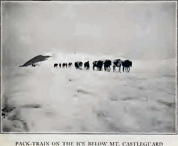
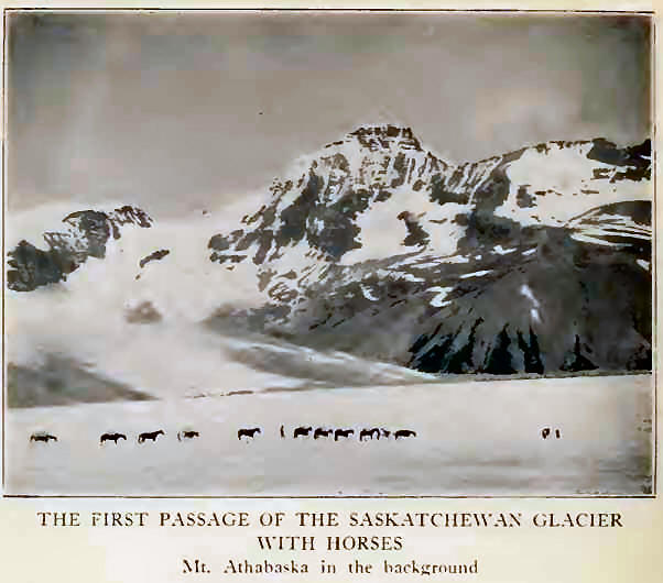
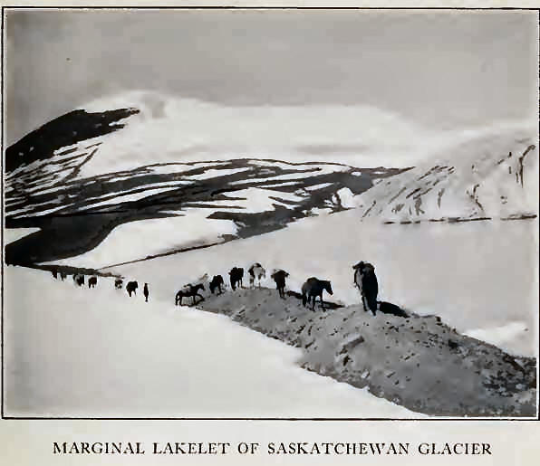
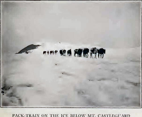
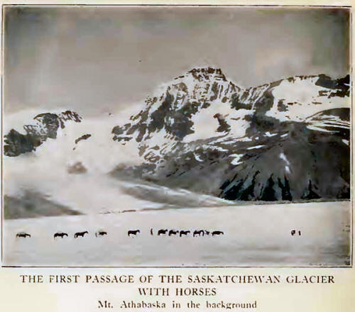
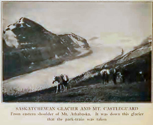
Saskatchewan Glacier, nearly opposite Mount Athabaska. A shore of flat
moraine permitted the pack-train to progress to level ice. Our horses on
the glacier made an unusual pronto identify
the route, and because of the dominating peak, the name “Castleguard
Pass” is suggested for the pass between the head of Castleguard Valley
and the Saskatchewan Glaciers.
cession; but, at first timid, they soon became accustomed to their
surroundings and, like true mountaineers, hopped over the little cracks
and crevasses. It was necessary, in avoiding a lateral glacier entering
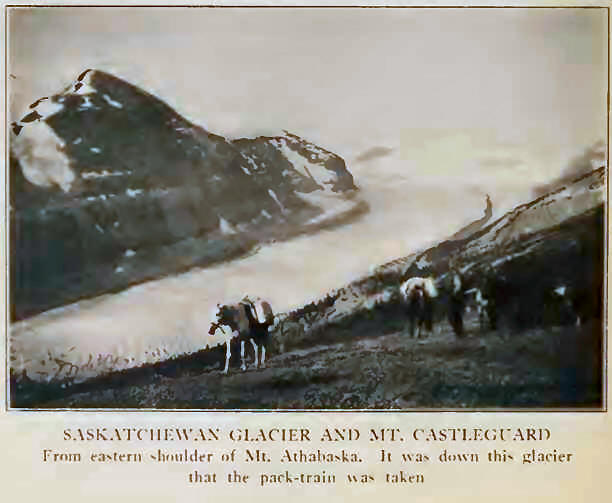
from the south, to take to the central ice for a short distance. The
horses were taken down the glacier for more than four miles, with
devious winding around the large transverse crevasses. The steep
terminal moraine, with treacherously balanced boulders and slippery
glacial mud, was most troublesome, requiring some trail-building and
considerable care to avoid damage to the pack-train. But before evening
the last horse was safely off and camp finally made below the tongue on
the flats toward the south side near a pleasant waterfall. Close by, the
stream enters a narrow canyon, spanned by a natural bridge; apparently
no one else, with horses, had ever stopped at our Glacier Camp.
At
daybreak, without difficulty, we took the horses northward over a
meadowed shoulder east of Mount Athabaska, about 7500 feet in elevation,
whence we looked back and over the tremendous expanse of green ice to
Castleguard. We could scarcely believe that the cayuses had come down
such a place. The descent to Sunwapta Pass was direct, through grassland
and open timber to the river, whence we followed trail across the true
Saskatchewan-Athabaska divide to camp not far from the tongue of
Athabaska Glacier.
It
was a place to remember. The valley-flat, bordered by ancient
timber—from whose dusky shadows rushing brooks emerge—is sparsely
covered by thickets of scrub-evergreen and willow. We spent delightful
minutes in watching the antics of gopher: furry little beasts, and
childishly curious. Franklin grouse, the “fool-hen” of the Northwest,
were abundant; the hens often paraded close to the tents, bringing
several chicks for our inspection and showing not a trace of fear.
Several lakelets on the Athabaska moraine are remarkably deep and blue
for their size; their shores are a salt-lick, crossed and recrossed by
game tracks; four sheep bounded away when we first walked there. Several
days later the cook served up a savory dish which tasted very much like
mutton. None of us could guess where it came from; but, from the grin on
Jim’s face, it is barely possible that he might have solved the riddle.
The
Athabaska Glacier is the chief source of Sun-wapta1
River, the Sunwapta Pass, some four miles southeast of Wilcox Pass,
dividing ultimate sources of North Saskatchewan from Athabaska drainage.
Wilcox Pass is really not a pass at all, but a detour on the Sunwapta,
by which the eastern meadows of Wilcox Mountain are rounded to avoid a
deep canyon below the Athabaska tongue. The glacier itself is
spectacular enough; it descends in three icefalls, from the Columbia
field, through the gap between Mount Athabaska and The Snow Dome. The
tongue flows for more than five miles and spreads in an enormous
uncrevassed fan close to the trail. The headwater of the Sunwapta is
augmented by the fall of Dome Glacier, plunging down between The Snow
Dome and Mount Kitchener. Nowhere else did we observe a greater quantity
of falling ice; scarcely an hour passed without resounding crashes
announcing a streaming avalanche.
By
the north glacier and the northwest arete we made, on July 19th, the
third ascent of Mount Athabaska (11,452 feet). It is such a radiant,
dazzling mountain when the sun shines on its unbroken northern snow; and
it was a pity that we had wretchedly bad weather. The route, above
timber-line, was entirely on snow until the final crest was reached and
an occasional rocky outcrop found. There are several steep slopes where
one must traverse laterally for short distances under a bit of hanging
glacier; some enormous blocks lie frozen high up in the slope, and here
only were we glad that the day was not too bright. Less than six hours
brought us to the summit, a rising snow-wedge, without cornices. It was
snowing hard, and through holes in the fog we had just occasional
glimpses of the Saskatchewan Glacier. There was little to indicate the
presence of the Columbia Icefield, and although it was discovered from
this very point it would have been unseen if the first-ascent had been
made under weather conditions such as we experienced.
The
northwest glacier, by which we descended, is a variant of former routes,
but interesting and repaying because of a tumbling icefall which one may
safely approach. On the moraine we picked up a large trilobite fossil,
quite different from the small shell-fossils which load the strata below
the summit of Nigel Peak across the valley. There is a fine view over
the Athabaska Glacier to the peaks of Diadem and Woolley beyond; but
lowering clouds prevented our seeing very much of it, although the sun
came out again as we reached the lower moraine and walked back to camp.
We
had now completed our northern program as far as weather had permitted.
North Twin, Saskatchewan, Columbia, Athabaska, and lesser peaks had
fallen. The distances covered had been great: we had made two journeys
across the Columbia Icefield— North Twin a round trip of more than
thirty miles; Columbia but slightly less. North Twin, Saskatchewan, and
Columbia had been captured within five days, perhaps constituting, if
there be honour in it, a long-distance and altitude record in Canadian
mountaineering.
Simpson told us an interesting tale, portions of which I was able to
amplify, regarding the fate of Professor Coleman’s folding boat. It
seems that this craft, which had been taken to Athabaska Pass in 1893
for the purpose of navigating the Committee Punch Bowl, was utilized on
the return journey to carry one of the party down the Saskatchewan from
the Kootenay Plains to Edmonton. A canvas boat, presumably the same one,
was again taken by Coleman’s party in 1907, when travelling from Laggan
to Mount Robson. That it never arrived beyond the sources of the
Athabaska is indicated by the statement,3 “As our loads were
heavy and some of the horses had sore backs we cached the folding boat
and fifty pounds of supplies, enough to take us home from this point, in
a thick spruce-tree, fastening everything up tight in bags to keep out
winged or four-footed marauders. We hoped thus to make better time. This
cache we were fated never to see again, and if some later traveller has
not lifted it from the crotch among the branches of the old spruce, it
may be there still in its waterproof wrappings.”
The
cache, near Athabaska Glacier, remained untouched for several years.
Then along came an outfit and camped beside it. An outfitter, waking
suddenly in the night at the scratching of a small animal at the tent
door, and with dreams of a grizzly still confusing him, fired his gun
point-blank. The porcupine seems to have escaped unscathed, but a gaping
hole was blown in the side of the folding boat.
Later in the season Simpson took the boat down to the Saskatchewan
Forks, repaired it and used it for several years at the ford. It was
finally burned up by a couple of Indians who, for reasons unknown, bore
Jim a grudge. Thus ends the strange maritime history of a craft whose
lengthiest voyages were made on the back of a pack-horse through high
mountain regions!
On
July 20th, camp was broken, and in seven hours we had negotiated the
“Big Hill,” past Panther Fall, and the miles to Graveyard Camp. We could
not help walking out on the river-flat that evening for a last look at
Mount Saskatchewan. It is such a magnificent peak, the landmark of the
entire valley, and it seemed no less glorious now that it was ours.
On
the following day we crossed the Saskatchewan ford, camping below Mount
Murchison, and in the afternoon enjoyed a much-needed bath in a warm
shallow lake behind the tents. The old route was followed up the Mistaya
to Wildfowl Lakes and Bow Pass. We had come back from the sources of the
North Saskatchewan—it was journey’s end. |