|
“The man who can
drag himself up a vertical rock face when he can just get the
finger-tips on to one little ledge, will be of far less use in an
exploring party than the man who can judge quickly the state of snow”
Clinton Dent
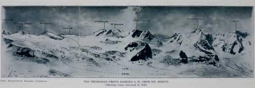
The Freshfield Group
was the goal of the Expedition undertaken, in 1922, by Howard Palmer,
Edward Feuz, and myself. We had come from Field with Jim Simpson, over
the Howse Pass trail; a route followed by David Thompson1
of the North-West Company as early as 1807—Joseph Howse, clerk of the
Hudson’s Bay Company, did not begin to use the pass until two years
later—and for four years ensuing, until hostile Indians of the western
slope forced the traders to turn to Athabaska Pass in crossing the
Continental Divide.
There seems to be no
mention of the Freshfield Group until 1860, when it was visited by Dr.
Hector, of the Palliser Expedition, while searching for the northern
approach to Howse Pass. He writes,2 “At
daylight I started with Beads to see where the valley leads to, and
after five miles through very thick woods, we suddenly emerged at the
foot of a great glacier [Freshfield Glacier] which completely fills the
valley, and showed us that there was no hope of getting through with
horses by this route. We ascended over
the moraines, and had a
slippery climb for a long way to reach the surface of the ice, and then
found that it was a more narrow but longer glacier than the one I
visited the previous summer [Lyell Glacier]. The upper part of the
valley which it occupies expands considerably, and is bounded to the
west by a row of high conical peaks that are completely snow-clad. We
walked over the surface of the ice for four miles, and did not meet with
many great fissures. Its surface was also remarkably pure and clear from
detritus, but a row of large angular blocks followed nearly down its
centre. Its length I estimated at seven miles, and its width at one and
a half to two miles. By three p. m. we had returned to our halting-place
of yesterday, and now proceeded to try Beads’ valley.
“For three miles we
followed up the stream to the south, until we found that it suddenly
rose from a glacier [Conway Glacier] in a high valley to our right.
However, as the valley before us continued to look wide and spacious,
with a flat level bottom covered with dense forest, we left the river
and continued a southerly course, sometimes seeing little swampy
streams, which showed us that the water was still flowing to the
Saskatchewan. After about three miles we observed a small creek issuing
from a number of springs, to flow in the direction in which we were
travelling; but we could hardly believe it to be a branch of the
Columbia, and that we were now on the west slope of the mountains,
seeing that we had made no appreciable ascent since leaving the main
Saskatchewan, and had encountered nothing like a height of land. We
camped here beside a small lake and beautiful open woods, where the
timber is of very fine quality.”

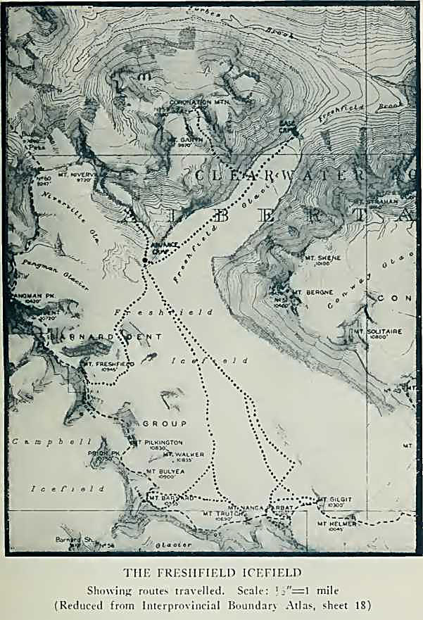
The Freshfield Group is
situated on the Continental Divide, in latitude 51° 39' 51", between
Howse (5010 feet) and Bush (7860 feet) Passes, an air-line of some ten
miles; although, due to the southwesterly bowing of the watershed
between the two passes, the actual crest of the group is much longer.
Howse Pass lies nearly a hundred and twenty miles south of Yellowhead
Pass; and in 1881, the year of chartering the Canadian Pacific Railroad,
it had been decided to abandon it in favour of the Yellowhead route,
since the latter afforded a lesser gradient. It was felt, however, that
a more direct route to Kamloops could be found; and, when in the
following year the practicability of Rogers Pass across the Selkirks’
summit was ascertained, the railroad was finally diverted to its present
location in Kicking Horse Pass. The Howse Pass is perhaps forty miles
from Kicking Horse, but the distance by trail from Field to the
Freshfield tongue is more nearly sixty-five miles. Between Howse and
Athabaska Passes—less frequented than in olden days—there is no
intervening gap in the Divide through which horses can be taken; the
western slope is steep and heavily forested, while the valleys, draining
to the Columbia, through Bush River, are unsuitable for travel
paralleling the main range.
On the western side of
the Freshfield Group, the Campbell Icefield forms a chief source of the
south fork of Bush River, draining to the Columbia. The Freshfield
Icefield itself, some twenty square miles in extent, fills the eastern
cirque, and discharges by a single tongue, three miles long and
three-quarters of a mile wide, its stream being an ultimate source of
Howse River.
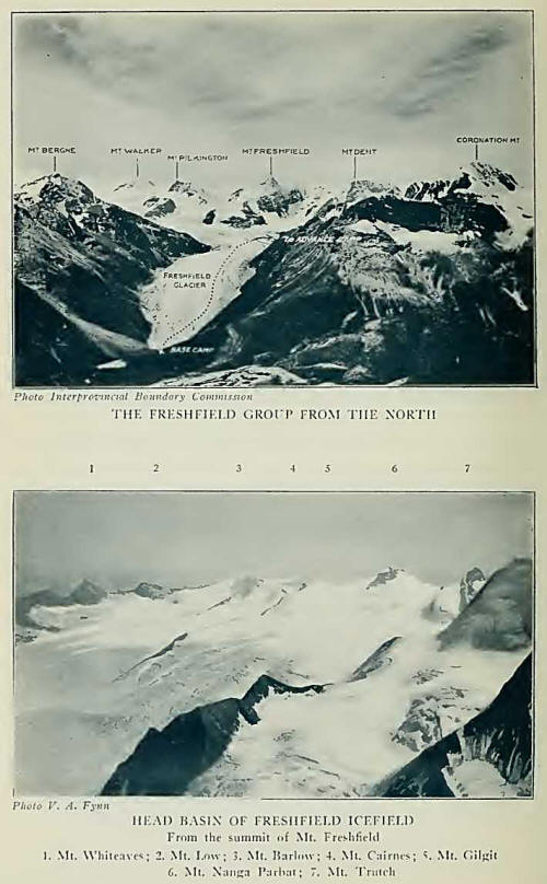
The chief peaks of the
group lie on the Divide, subsidiary ridges extending east and southeast
to enclose large glacier cirques, of which the Conway, Lambe, Cairnes,
and Mummery are the most extensive. In the group are approximately
thirty peaks of importance, of which at least twenty-four exceed 10,000
feet in altitude. The watershed summits are chiefly snowy peaks; those
on the subsidiary ridges of the eastern wall are scarcely of lesser
height, but generally more rocky in appearance.
Climbing parties in
this region have been infrequent, chiefly because of the distances
involved. In 1902,3 an Anglo-American party
consisting of Messrs. Collie, Outram, Stutfield, Weed, and Woolley, with
the guides Hans and Christian Kaufmann, made the first-ascent of Mount
Freshfield (10,945 feet). In 1906, with Gottfried Feuz and Christian
Kaufmann, Messrs. Burr, Cabot, Peabody, and Walcott ascended Mount
Mummery (10,918 feet), from a camp in the upper Blaeberry Valley. Eaton
and Marocco, with Heinrich Burgener, came out from England in 1910, and,
from camp at the Freshfield tongue, traversed Mounts Dent (10,720 feet)
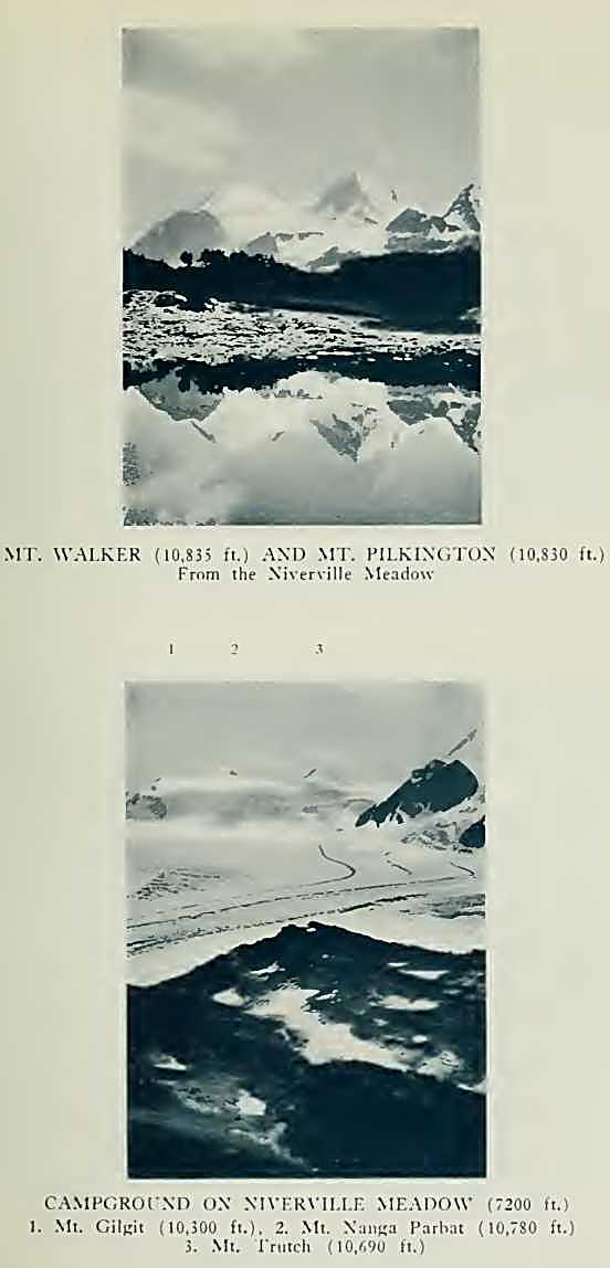
and Freshfield, over the intervening, unnamed snow-dome. They likewise
made first-ascents of Pilkington (10,830 feet), Walker (10,825 feet),
and a snow peak on the Divide, south of Pilkington, for which the name
“Burgener” was suggested, but which has since been named Mount Bulyea
(10,900 feet). During 1917, the Interprovincial Survey occupied a number
of high ridges and summits, including Bergne (10,420 feet), and Lambe
(10,438 feet). In 1920, Messrs. Eddy, Fynn, and Mumm, with Rudolf Aemmer
and Moritz Inderbinen, made the third ascent of Freshfield. Other
climbers who have reached the group accomplished little or nothing
because of bad weather.
In 1922, Howard Palmer
and I had the good fortune to visit the group, with Edward Feuz as
guide, and make a number of ascents. On the new map of the Survey, we
discovered that there was a peak on the Divide—Mount Barnard (10,955
feet)—higher than Freshfield and, therefore, the loftiest of the entire
group. Barnard lies south of and hidden by the Pilkington-Bulyea ridge
and is quite invisible from the glacier-tongue. The difference in height
between it and Freshfield is not great, and these facts explain in part
why the mountain had for so long remained unattacked. We determined to
make it our objective.
We had come from Howse
Pass on July 10th, a short ride down Conway canyon to the lower flats,
and thence up trail through forest, rising sharply and emerging on a
morainal terrace with the broad ice-tongue close at hand and Mount
Freshfield, southward, rising to a slender peak. A grassy slide nearby,
gay with columbine, paintbrush, and forget-me-nots, affords a welcome
feeding ground for the horses. Strangely enough, good grass is
exceedingly scarce between Field and the upper Blaeberry, and there had
been many long morning searches for wandering cayuses.
A glacier never fails
in its fascination. The snout where the milky stream begins, is the
balancing point in the battle between onward motion and dissipation.
Most glaciers are retreating, slowly but steadily, although such changes
are cyclic and advance may someday begin. About the tongue are blocks
and boulders, weighing tons, carried down from higher points, in
moraines, and left behind as the ice retreats. Were it not for their
slow motion, glaciers would be among the greatest of natural
transportation agents. The glacier surface is often flat and easy to
walk on; but ice is not perfectly plastic, and, where it moves over
declivities, crevasses and chasms are formed, with blue walls and
toppling pinnacles. Little surface streams from melting ice rush down,
banking and swirling in their frozen canals, eventually to disappear in
the depths of crevasse or moulin, which Dr. Hector noticed, are
scattered about, although they have moved some distance in the
intervening time; the snow-covered conical peaks—Walker, Pilkington,
Freshfield, and Dent—remain unchanged. The huge upper snow-basin, from
which, as from the neck of a bottle, the glacier-tongue extends, is not
seen in its entirety until one travels some distance up the ice. The
basin receives snow from the magnificent curve of watershed peaks: there
are broad, undulating slopes from the peaks eastward toward the
Blaeberry; a higher level of icefall and plateau from the south, from
Nanga Parbat to Dent; and, from the direction of Bush Pass, smaller
glacier-tongues, which, in retreat, have disconnected from the icefield.
From a few of the
peaks, rocky buttresses with peninsulas of meadow push out to the
glacier margin. It is quite easy, as we found, to back-pack up the ice
and make camp on such a spot. On July 11th we reached a heather-covered
alpland, below Mount Niv-erville,4 pitching our
tent' beside a tiny brook, with banks of spring snow still remaining.
There were trees, but dwarfed and twisted by storm. Flowers everywhere,
as never seen at a lesser elevation; and, at sunset, the snowfields and
mountain tops lighted by a procession of colours, ethereal and baffling.
The icefield may be
roughly divided into three sections: an icefall basin, descending
between Dent and Walker; an upper snow-basin, rising high up on Walker,
extending southward to Mount Barnard and eastward to the snowy dome of
Gilgit (10,300 feet), where it drops off in cornices and cliffs; and a
lower head-basin descending from the slopes of Mount Barlow (10,320
feet), and adjoining peaks, and connecting with the other divisions in a
series of icefalls and flat ice-areas that eventually form the
Freshfield tongue. From the minor peaks on the south side of Bush Pass,
the Niverville and Pangman Glaciers descend into the Freshfield basin,
but are at present only loosely connected with the icefield. The
Niverville stream runs under the Freshfield ice, while a subsidiary
pressure tongue of the Freshfield basin actually faces up-stream toward
the Niverville tongue. Much of the upper ice is stagnant, with surface
drainage incomplete, and in the late afternoon the ice is covered with
water, in some places to a depth of six or eight inches. Our high camp
was a fine place from which to see the long sinuous medial moraines,
trailing back for several miles to the promontories in which they
originate.
Climbs from the high
camp were made on the days that followed, with intervals during which we
occupied ourselves with a survey of the glacier-tongue and a rough study
of the ice movement. On July 11th, Edward and I put out a line of
stones, 1100 yards above the ice terminus, Palmer lining them up with
the transit and signalling to us from a station on the western lateral
moraine. The width of the glacier is here 1000 yards; our fourteen
stones, at one-hundred-and-fifty-foot intervals, were remeasured on the
morning of July 19th, after a time period of six full days. We
calculated the motion as being between four and five inches per day,
which is in agreement with the July movement of other glaciers on the
main chain.
On the first medial
moraine east of the central axis of the glacier, Jim and I found a small
area, near the base of Mount Skene (10,100 feet), where there are
curious clusters of iron pyrite, many of them larger than a golf-ball,
riding free on the ice surface. This deposit was observed in no other
location except for a small bit picked up in the Garth-Coronation gully
just below the hanging glaciers. The immense boulders in the medial
moraines are remarkable for their average large size. Some are as big as
a bungalow, and afford amusing climbs. The largest of all on the ice was
ascended by Edward, who built a little cairn on top. The occurrence of
such enormous boulders appears to be related to the so-called “Block
Moraine,” supposedly due to ancient seismic disturbance.
On the southern wall of
the icefield were situated our objective peaks. On July 14th, we were
successful in making the first-ascent of Mount Barnard,9 loftiest summit
of the group. With an early start, we descended slopes of grass and
shale between our little camp and the ice. We were in shadow, but rosy
light, striking through the mist-bands clinging to the cliffs of Mount
Solitaire, diffused across the upper snows and came down to meet us as
we walked along.
Dawn, on a glacier,
often comes silently. Streams have almost vanished, and resume their
turbulent rushing only when sunlight again falls on their sources. The
crags and buttresses, from which trail long winding moraines, seem close
at hand. But distance, on snow and ice, is deceptive. The moraines are
here flat and compact, yet not so royal a road as the level ice. We
advanced four miles without difficulty, jumping over smaller crevasses
and deviating for larger ones.
Not many hours passed
before we reached an elevation at which snow covered much of the ice,
concealing the crevasses and making the use of the rope a necessary
safeguard. We were soon in a labyrinth of crevasses, which we threaded,
cutting steps, or crossing by firm snow-bridges from which hung shining
icicles that dripped water into blue depths and darkness. No sounds save
the bell-like tinkle of water dripping against the ice, and the faint
whisper of an early morning breeze sweeping up the slopes—a near silence
broken by Edward, admonishing us to walk like cats and by no means to
jump on the snow-bridges. There were places where we balanced like
acrobats, on the crests—Edward dubbed them “garden-walls”— between two
crevasses. Huge things those crevasses were: some nearly a hundred feet
wide, quite equal to that in depth; and, curiously enough, snowed up
flatly and solidly at the bottom. One could have roped in and walked
around for some distance.
Then, from a higher
plateau, we gazed upon our long-hidden mountain. White and gleaming it
was, lifted up in the haze of distant forest-fires in British Columbia,
until it seemed to touch the sky. Crossing a mile of flat snow, we
reached its base at the eastern end. The northeast face is snowy and
broken by large schrunds, and here was the only visible point where they
were sufficiently bridged to allow of crossing. We tackled a wall of
steep, soft snow, above a tiny bergschrund, moving cautiously and
anchoring deeply, slowly but surely to the main arete. It was not done
in a moment.
A high wind tugged at
the rope as we walked along the ridge, and we were glad enough to pull
our caps down over our ears. Vast ice-basins lay below us, snow slopes
falling steeply on the north; while unbroken couloirs, partially
ice-filled, curved giddily to the southern and western glaciers. Far
ahead, rising above an ascending succession of lesser snow-blown crests
of the ridge, gleamed the slender, highest point. Two hours were spent
in following the ridge; the ice-axe came more frequently into play;
speed lessened. A last bit of cutting in the ice of a couloir-head
brought us to the base of the snow-spire, and in a few minutes we were
on a summit scarcely big enough for the three of us at once. It is good
to be alive at such a moment, and, for a time only too short, stand as
the little monuments of such a glorious pedestal.
The highest summit of
the Freshfield Group was ours. At a quarter to eleven we had attained
its respectable elevation of 10,955 feet, in a little less than seven
hours. While distant views were somewhat obscured by smoke, the sheer
drop on the south and west to the Campbell Icefield was always
spectacular. We built a little cairn and ate our lunch; then retraced
our steps back along the ridge until the sharp arete descending
northward toward Mount Bulyea could be reached. The snow was in good
condition and we made our way rapidly downward. A sudden gust of wind
snatched Palmer’s hat and sent it sailing through the air. For a
thousand feet it went before touching the snow, finally spinning down a
steep slope and coming to rest. We soon glissaded down to the basin
eastward, finding the hat almost in our path; not often is head-gear
blown down from a mountain-top into a glacier basin and found again!
The day was not far
advanced, lacking still a halfhour until noon. Finding ourselves close
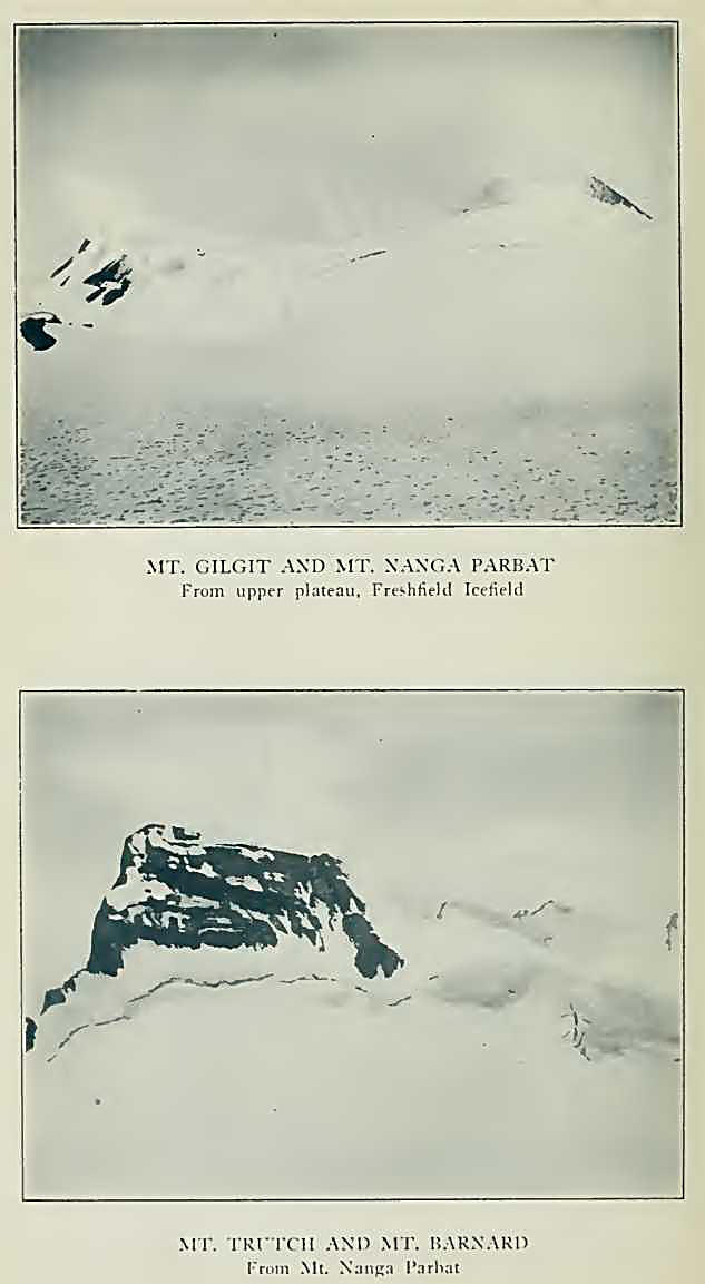
to the base of Mount Trutch (10,690 feet), we decided to ascend it as
well. Peculiarly wedge-shaped, this fin-like peak of the Divide had
attracted our attention from camp. Like Barnard, this mountain is named
for a past Lieutenant-Governor of British Columbia;9
and so there is a mixed nomenclature superimposed upon a group that
Collie, its first visitor, had attempted to preserve for prominent names
of the Alpine Club. On the northeast face of Trutch is a steep hanging
glacier, while on the southwest a cliff descends to the snow-basin. A
single northwest arete rises like a ridge-pole to the summit, followed
by a sheer drop to the ice. The arete itself is of shale and snow,
presenting no great difficulty; but the last four hundred feet,
invisible from below, turned out to be a knife-edge of rock, which had
to be straddled and took a good hour to negotiate. On the summit, at two
o’clock, we piled up a few stones to commemorate our visit. Ten hours
had elapsed since starting; not often does one make two first-ascents
above 10,000 feet, in a single day! There was no alternative route but
to retrace our steps; so we faced about, reached the snowfield, and
tramped back to camp feeling that our day had been a successful one. We
had travelled about fifteen miles on the ice.
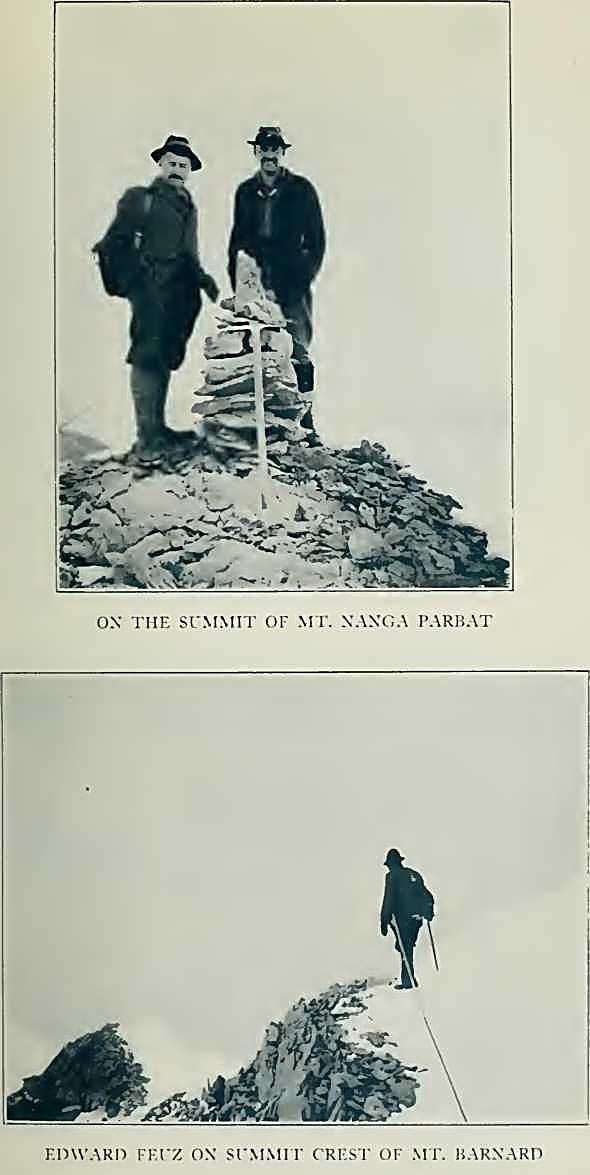
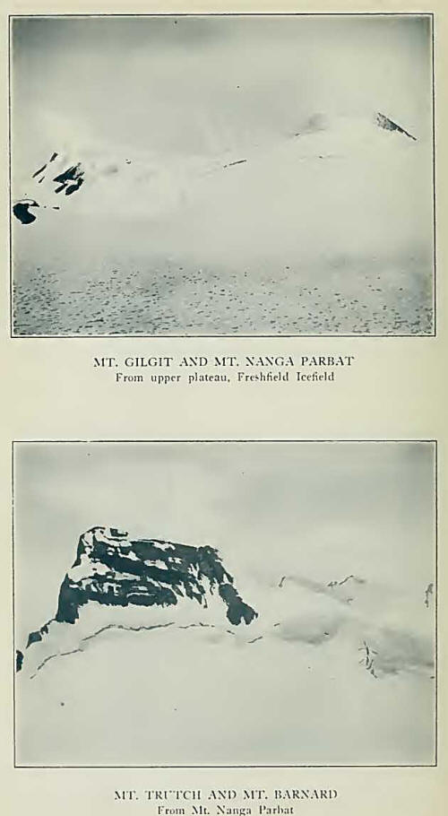
To the east of Trutch
rises the symmetrical, snowy peak of Nanga Parbat (10,780 feet), and
farther eastward, the dome of Gilgit (10,300 feet), heavily corniced on
the northeast where it falls off to the lower head-basin of the icefield.
On July 16th, we left the high camp at a quarter of four—at least we
think so, although our clock had been set by the average of three
guesses and did not agree with the rising sun! Crossing the lower ice,
our way lay through the crev-assed draw just west of the conspicuous
moraine and rock-ridge swinging down from Gilgit. Reaching the upper
basin, which is uncrevassed and sloping just enough to make a fine
ski-ground, we crossed to the base of Nanga Parbat, working across a
little schrund and up the shaly northwestern buttress, which from camp
looked like an enormous black gendarme. Here there was a bit of
climbing. I was the middle man on the rope and Palmer last—Edward having
jokingly remarked that he wanted a good anchor on the end, in case he
should unexpectedly plumb the depths of a crevasse—and for a short
stretch my view was entirely obstructed by our guide’s boot-soles,
scratching their way upward.
The morning mist was
rising; everything became hidden except the foreground, but we were soon
on the crest and followed a steepening snow-ridge to the summit. Clouds
continued to blow in, so after a short rest we descended to a warmer
corner, along the southeastern rocks, where slopes on the west allowed
us to cut down to the bergschrund. This we jumped—the slope was steep,
and our form most execrable—and skirted the base of the mountain to our
old track on its northern side. Keeping high on the slopes, we crossed
to Gilgit, and ascending from the west were on top a few minutes after
noon.
The weather, which had
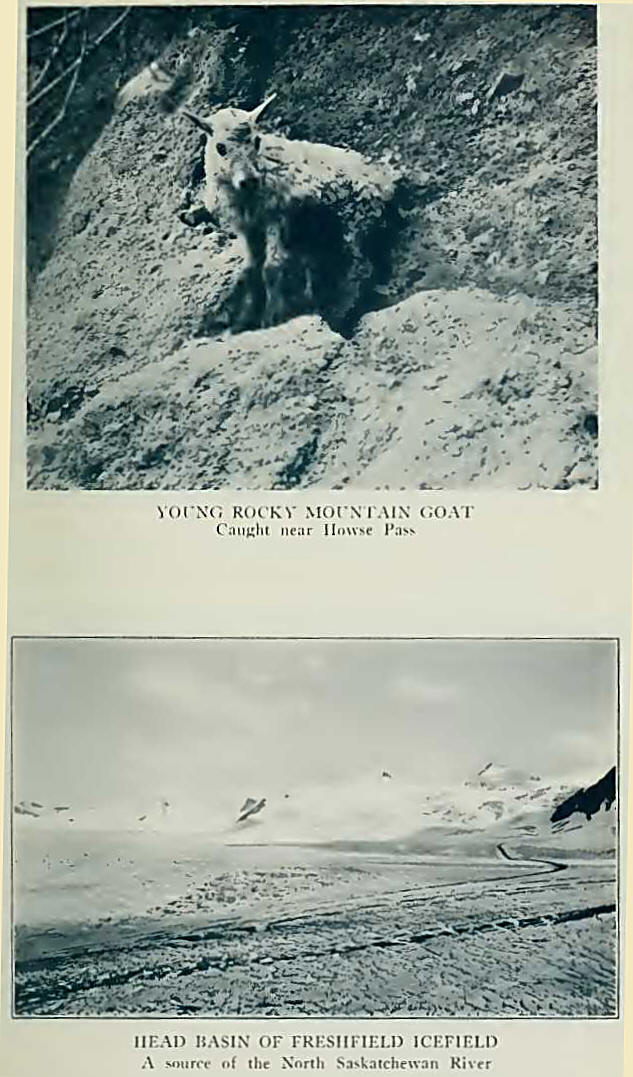
been smoky, cleared suddenly. The icefield below us in unbroken
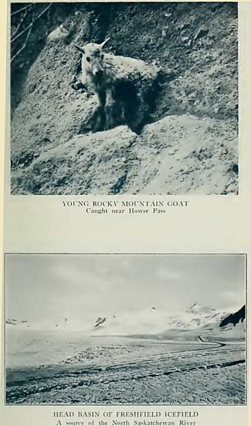
whiteness is the southerly terminal source of the North Saskatchewan.
That tiny green island at the ice margin is our meadow camp—absurdly far
below, as if on a different planet. Howse River is seen on its northern
course. Mount Forbes (11,902 feet), the fifth elevation of the Canadian
Rockies, towers across the valley; a grim, snow-powdered spire it is,
worthy of comparison to the Matterhorn or the Dent Blanche, although
from few points can these Swiss peaks equal their Canadian rival in
sheerness of line. Beyond, in the north, distant peaks are visible—Lyell
and Columbia—with bits of icefield that seem like great white birds
soaring afar. To the south and west, one gazes across glaciers and
towers from which descend streams to the Bush and Columbia Valleys; and
across the ranges to peaks of the Selkirks, rising dimly in the haze.
The southeast ridge of Nanga Parbat curves brokenly and rises in dizzy
heights to the spires and pinnacles of Mount Mummery, whose black
precipices wall the head of Waitabit14 Valley.
But it was always the
icefield itself that held our attention; we were never tired of admiring
the prospect, perhaps because its contrasts made it one of the most
picturesque landscapes we had ever seen. The vast field of ice, at its
terminus, is in close apposition to the dark green of fir-trees, beyond
which is a flat of gravel-islands through which runs the river, a
silvery line, into the north. Distant patches of yellow meadow cling to
the bases of dark, shattered towers; range after range is seen, in
relief intensified by sunshine and shadow; snowfields are glittering, in
light which might in a moment be cut off in the blue shadow of moving
cloud.
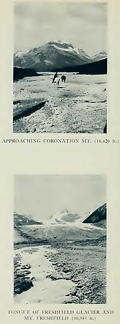
In just five hours from
the high camp, on July 18th, we were on top of Mount Freshfield (10,945
feet), the only summit of the group that has been climbed more than
once. The route up a broad snow-filled gully, just east of the
Freshfield-Dent icefall, leads in interesting fashion to the slopes
opposite Pilkington. Ascent was then made obliquely to the south and the
summit gained over an easy rock crest. The day was smoky and we had no
distant view; so a glissade was made homeward, camp being reached in
many minutes under three hours. Edward soon had a bowl of erbswurst soup
ready, and after lunch we struck the tent and packed our belongings down
to the Freshfield tongue.
All this time, Jim had
packed bread—and an occasional ptarmigan—up to the high camp for us.
Bill and Tommy down below had been getting restless, although they spent
part of every day on the glacier, prospecting in the moraines.
On the last day, July
20th, Edward and I made the ascent of Coronation Mountain (10,420 feet)
from the Freshfield Glacier.15 It is the imposing, massive peak named by
Collie, and is well seen from the mouth of Forbes Brook as a broad-based
rock mountain with a steep glacier on its northern face. Leaving camp at
four o’clock in the morning, we ascended the ice for more than a mile
and took to the bush on the north side of a gully sloping down between
Mount Garth and Coronation. At timber-line, steep grass slopes and loose
rocks led up to morainal debris below two small hanging glaciers; the
tongue to the north was reached without delay and the snow above
ascended, a sharp watch being necessary because of occasional stones
falling from a wall nearby. It was not altogether easy; the slopes
became steep and hard, requiring some cutting before the arete was
reached east of the pyramidal summit. Two rocky gendarmes were traversed
below the top, the sheer drop to Forbes Brook making it an exciting
performance. Mount Forbes was directly opposite, its superb ridges
looming grandly through the smoke, and we could trace out the difficult
route by which it is ascended. But we had no distant view, and a
chilling wind compelled us to beat a retreat as soon as a cairn was
built. Glissades on the steep slopes made descent rapid, and we reached
camp shortly after noon, quite ready for lunch.
Forest-fire smoke,
occasionally a drawback in Canadian mountaineering, continued, so on the
following day camp was broken. We had climbed six lovely peaks, each
exceeding 10,000 feet in elevation, and were inclined to be quite
content with our luck. But let no one think that the climbs have been
exhausted; more than half the peaks of the group remain virgin,
Freshfield being the only one of all that has been visited more than
once. Several of the unclimbed peaks —Garth (9970 feet), Pangman (10,420
feet), Helmer (10,045 feet), and Solitaire (10,800 feet), to mention
only a few—appear difficult enough to keep strenuous climbers out of
mischief for at least a week or two.
John McDonald of Garth,
fur-trader, was in charge of Fort George in 1793, and of Fort de l’lsle
on the Saskatchewan in 1805. Rocky Mountain House was built under his
direction in 1799. He crossed Howse Pass during the winter of 1811 to
bring supplies to David Thompson on the Columbia.
Peter Pangman, an
original partner of the North-West Company, ascended the Saskatchewan as
far as the location of Rocky Mountain House in 1789.
Nowhere in the Rockies
can one reach such a tremendous icefield with greater ease, and the
possibility of establishing a high camp will ever be an advantage when
the more distant peaks are to be gained. There are problems for the
student of glaciology; and, in this area, many are the unanswered
riddles. The scenic magnificence of the upper basin is beyond all words:
no description does justice to sunsets, such as we saw night after night
from the soft heather-carpet of the upper meadow, turning the icefield
into a bowl of colours that would have puzzled an artist.
You should go there
yourself to understand. Perhaps you will see the range as we did, one
day when a layer of mist and fog hid all the mountains and left only the
icefield and the lower cliffs visible in sombre hue. The sun broke
through; a little breeze came up; there was a lowering of the
mist-level; the snowy peaks appeared above in gleaming iridescence. The
illusion could not have been bettered—it was as if another Universe were
floating in space, close above our own. |