|
British Columbia—Mineral
products—Dr. Dawson’s report —Development—Gold—Vicissitudes of
mining—Copper and zinc—Percentages—The “Lucky Jim”—Marble quarries—
Portland cement—Petroleum—Demand for a government— — Constitution — The
Kootenay district—Lumbering — Yale district—Railway
extension—Lillooet—The climate—Through the Yellow Head Pass—The
Athabasca River—Brule Lake— Roche Miette and Roche Suette—Sulphur
springs—Pyramid Mountains — Geikie — Moose River — Sehvyn and Rainbow
Mountains—The premier of the Rockies—Lake Helena—A steamboat on the
rapids—The Naas Valley—The Skeena Valley—Vancouver Island—Comox
district—Minerals and timber—Saw mills—Homesteads—Land Clearing and
Irrigation Companies—Gold medal award—Fruit.
THE area of British
Columbia is estimated at 285,000 square miles. There are four chains of
mountains traversing the country in a northerly direction with extensive
valleys between. It is proved that each of these ranges is rich in
minerals, whilst the valleys immediately to the west of the Rocky
Mountains contain gold, which in some places is being worked with
prosperous results.
The Rockies seem to the
traveller to be the presiding deity of the place. Around, above,
beneath, they are ever to be seen frowning, smiling, raging and sighing
by turn. If wealth be power, who shall approximately reckon the force of
the treasure that lies slumbering in its breast? The creator of the
fabled Aladdin might well have had his imagination fired in the heart of
these wondrous ranges.
The late Dr. George M.
Dawson, Director of the Geological Survey of Canada, has reported that
gold is so generally distributed over the whole of British Columbia that
there are few streams of any importance in which “colours” may not be
found. Up to the present only 20 per cent, of the province is really
known, and not half that portion has been sufficiently examined to
ascertain its real value. What has been ascertained is that 300,000
square miles of country is extensively mineralized.
Development has been
slow, owing to want of railway and road communication. For six years
previous to 1893, the lode mines had only yielded about £12,000
annually, but in that year the output reached £60,000. This has been
bettered in 1909, by amounting to £984,818. The geographical position of
the province was in the past a hindrance to rapid development, and the
markets for mineral wealth had been practically confined to the Atlantic
shores. All this has been changed, and along the Pacific coast the
complete progress of manufacture from the rough ore to the finished
article is taking place, saving time and the expense of freightage.
The value of placer
gold in 1909 amounted to £95,400, a falling off from the previous year.
The decrease was attributed to unfavourable weather, which affects the
gold harvest as well as the wheat. The mining of placer gold is
controlled by the supply of water, depending at one time on the snowfall
of the previous winter, at another on the rainfall of the spring. There
is another factor, however ; the more easily available deposits have
been largely worked out, and others requiring larger capital and plant
must be exploited. Again, fresh plant has to be reconstructed to meet
new requirements, and an idle period intervenes. The bursting of a dam,
which causes flooding and suspends work, defers the expected returns for
periods more or less prolonged.
As might be expected,
the vicissitudes of this kind of mining have to be coped with, and
speculation has uncertain results. At times the excitement over a “find”
is by no means justified by experience, at others hopes are realized
beyond the dream of avarice.
The total amount of
silver produced in British Columbia in 1909 was 2,532,742 ozs., valued
at £247,854. The four divisions of the Slocan district produced about 50
per cent, of the total. The Fort Steele mining division contributed 23
per cent. Most of the silver is found associated with lead, the rest in
copper-silver ores.
The lead comes chiefly
from the Fort Steele division, the remainder from the three divisions of
Slocan district, the Nelson mining division and a few others. In 1910,
the production amounted to 44.396,346 lbs.
The principal copper
districts are the following: Yale, (Boundary division) Yale, (Kamloops)
Ross-land, Cassiar, Nelson, and the Coast. The amount produced in 1909
was 45,597,245 lbs., all fine copper, valued at £1,183,104. This,
however, showed a decrease on the previous year of 1,677,369 lbs., or in
money value £64,345.
The zinc industry has
not been neglected, although the output is small compared with other
minerals. The total amount produced in 1909 was 10,000 tons of ore,
yielding from 38 to 48 per cent, of zinc.
The chief zinc mining
district in British Columbia is at the “Lucky Jim” in Slocan mining
division.
Platinum is found in
many alluvial gold workings as a by-product. The process, however,
involves so much labour that it has not been considered profitable.
An abundance of
building stone of various sorts is to be found in almost every part of
British Columbia. It is so plentiful and widely distributed that
quarrying has not become much of an industry, except in the vicinity of
large cities. A marble quarry has been opened in the neighbourhood of
Lardo-Trout Lake Railway in the interior. In 1909 blocks which were
excavated and sawed into slabs, amounted to £6000 value. The Marble and
Granite Co. used to ship the rough blocks for dressing. Works have since
been established which supply the marble in the finished state.
Large lime-kilns are in
operation in the neighbourhood of Victoria. This industry has been
extended to Saanich Inlet and Texada Island, where the limestone used is
of exceptional quality.
Portland cement has
demanded the formation of a company at Vancouver. The works are about
twelve miles from Victoria, at Tod Inlet on the Saanich arm. In 1909 the
output was valued at £72,000.
Petroleum is still in
the speculative state. The oil has been found in East Kootenay and in
Vancouver Island, but it has not been sufficiently worked to form a
clear notion of its value.
Concrete is so much in
demand on the coast, that quarries have been opened and companies formed
with extensive plant for crushing rocks and supplying washed sand and
gravel.
This brief epitome of
the natural resources of British Columbia is sufficient to show its
importance as a province of the Dominion. Geographically it is the
largest, prospectively it is without doubt the wealthiest.
Fifty years ago it was
unexplored territory, unknown, except to its Indian inhabitants and a
few
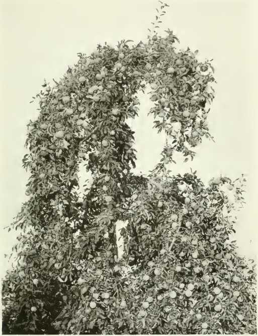
A NELSON APPLE-TREE
fur traders. When gold
was discovered on the Fraser River in 1857, people began to pour into
this hitherto isolated world. The demand for the establishment of some
form of government control naturally arose. Accordingly the mainland
west of the Rockies became a Crown colony and took the name of British
Columbia. In 1871 it was constituted a province of Canada, on condition
that it should be connected with the eastern territories by railway. The
Canadian Pacific was completed in 1885, which opened up direct
communication between the Atlantic and Pacific shores. A
lieutenant-governor is at the head of the Provincial administration,
appointed by the Dominion Parliament. There is an Executive Council of
five who are members of the Legislative Assembly, forty-two in number,
who are chosen by the Provincial constituencies.
The Kootenay district
lies in the south-eastern portion of the province, west of the Rockies,
and within the region of the Kootenay and Columbia rivers. In
consequence of its more advanced development, civic life is rapidly
spreading. The population has more than doubled within the last ten
years. Next to the mineral industries comes that of lumbering. The
timber is floated down the small unnavigable streams, which also supply
power for electric works, mills, etc. West of Kootenay, lies Yale
district, rich in arable land and at the same time mineral wealth and
timber. Within its limits are the fertile valleys of Okanagan, Nicola,
Similkameen, Kettle and Thomson rivers.
The Canadian Pacific
runs through the heart of the district. A branch railway and lake route
communicate with the south, whilst new lines are in progress, giving
access to further undeveloped agricultural and mining districts.
Lillooet requires the
advantages of railway transport; nothing else is needed to develop its
natural resources, which are potentially great.
Westminster has the
finest soil for cultivation in the province. It possesses all the
advantages of irrigation from the Lower Fraser, which courses through
its valley, stimulating its fruitfulness, as well as creating an
extensive lumbering industry. A considerable portion of the Fraser
Valley has been dyked, so supplying a still larger area for cultivation.
The climate is mild, and there is a plentiful rainfall during the winter
months.
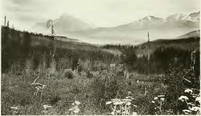
Going north, the
districts of Cariboo and Cassiar are traversed. Apart from the track of
the great rivers the whole region is practically unexplored. Cassiar
lies in the Peace River country between latitudes 64° and 6o°. North and
south of the river there is an extensive agricultural region. The
southern area is principally prairie and poplar copse, with good soil.
Early autumn frosts prevail. Cassiar has already yielded samples of good
wheat, and there is every
reason to expect that a
large population can be sustained by its natural products. The climate
is good and adapted to the needs of successful agriculture. The wheat
season is short, but certain in its harvest.
An agreement has been
made with the Dominion Government for the laying down of railways in
Cassiar. Three and a half million acres were ceded for this purpose. The
completion of the Grand Trunk Railway, now in progress, and the laying
down of good roads will hasten development, and the great hopes and
possibilities of this hitherto trackless wilderness will be practically
fulfilled. The route is via Edmonton, and extends to Prince Rupert on
the British Columbia coast. It exploits a new territory, and opens a
fresh volume in the sublimity and grandeur of the Rocky Mountains. It
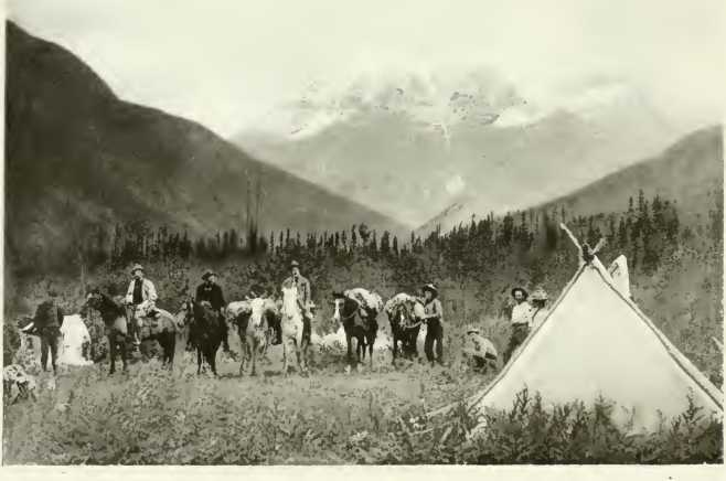
traverses the Yellow Head Pass.
Between Edmonton and
the mountains, a distance of 125 miles, the survey shows grassy plains
interspersed with wooded slopes. The line skirts the south side of the
Athabasca River, which broadens from twenty feet at McKay, to nearly
three hundred feet at Prairie Creek. Mountains 7000 feet high come into
view at that point, and Jasper Park is touched, where the Dominion
Government has formed a 5000 square mile reserve for the preservation of
the magnificent specimens of flora and fauna life in primitive wildness.
Two hundred miles from
Edmonton, Brule Lake is reached. It is an expansion of the Athabasca,
and acts like a dock to the river, broadening it two miles wide further
on. The mountains rise on each side of this waterway, culminating in the
peaks of Roche Miette and Roche Suette. Snow-capped eminences are
sighted further on, known as the Fiddle Range.
A peculiarity of
atmospheric conditions attests the presence of sulphur springs. The
odour can be detected half a mile from its source. Analysis has
ascertained that these springs are from hi0 to 1270 Fahrenheit, and are
said to possess important medicinal properties.
The Pyramid range of
mountains, 9700 feet high, Jasper Lake, Fish Lake and Rocky River are
within easy reach. The magnificent peaks rise in silent guardianship,
and cast dark shadows over the water. The scenery is further varied by
deep canons with precipitous walls.
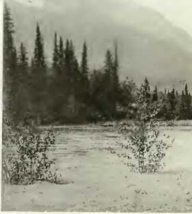
Two hundred and forty
miles from Edmonton, the ranges of the Rockies are reached. Geikie is
one of the principal, and marks the parting of the ways between the
provinces of Alberta and British Columbia. At Yellow Head Pass, the
great Fraser River is sighted with its numerous affluents. Born amongst
the glaciers, it extends through the province of British Columbia, a
distance of nearly 1000 miles. The Moose River debouches into it east of
Moose Lake, and the railway crosses it by means of a bridge.
Sixty miles further on,
the Selwyn range of mountains is skirted north of Moose Lake. Its base
is thickly wooded, its summit set in snow. Red and yellow colouring,
the. characteristic markings of the Rainbow Mountains, are easily
recognized in that locality. But all these ranges are surpassed by the
peaks of Mount Robson, which reach a height of 13,700 feet above
sea-level. It not only holds the premier place in the Rockies, but is
unequalled throughout the American continent. This mountain finds a
fitting auxiliary to its grandeur in Lake Helena, silent in its depths
as the towering peaks above. From Tete Jaune, Fort George can be reached
by canoe. A steamboat made the reverse passage in July 1910 for the
first time. It took six days to do the 80 miles’ journey, owing to the
force of the current. Below this point, the mountains give place to
hills and wide fertile plains suitable for fruit growing and dairy
farming.
From Fort George the
proposed line stretches through Bulkley Valley to Hazelton, and thence
to Prince Rupert.
The Naas River Valley
is abundant in timber such as spruce and hemlock. It is navigable for
forty miles, and at the point where this route ends, there is a ten-mile
wagon road. A forward movement awaits only better transportation and
more roads in the Skeena Valley. Its fruit-growing capacity has already
been established. The Grand Trunk system is projected to run along its
banks towards Prince Rupert and also intersects Bulkley Valley, which
has pasture land round Aldermere Lake of a light nature, good for
vegetables and fruit. Other parts of this extensive valley contain
resources for industry that in the near future will be developed.
Vancouver Island
possesses all the natural resources in more or less degree that are
distributed over the entire province. These include coal mining, copper
smelting, quartz mining, lumbering, fishing, and such like. The railway
of the Esquimalt and Nanaimo Co. runs from Victoria to Wellington
through scenery as rich in beauty as in intrinsic worth. The Canadian
Northern Railway, already on its way to British Columbia, has included
amongst its extension a track through the island.
The agricultural
regions are so thickly timbered that the railway company has arranged
for the clearing of large tracks. The island is eminently adapted for
the growing of grain, vegetables and the choicest fruits. The latter
flourish best in the south.
In Vancouver and some
of the smaller islands extensive deposits of iron have been discovered.
The largest quantities contained in the province are found there, and
the ore is said to be entirely free from sulphur and phosphorus.
The Comox district
occupies the northern territory of Vancouver, as well as a part of the
mainland. There is a stretch of thirty-five miles of fine
MOUNT ROBSON
productive soil between
Campbell River and Comox Bay. Minerals abound in this locality as well
as timber. The latter consists of Douglas fir, cedar and western
hemlock, probably unexcelled by anything in the world.
The Douglas fir takes
the first place, and grows as far as 510 north, where it gives place to
cedar, hemlock, cypress and spruce. The firs along the coast grow to the
height of 300 feet, with a circumference of 30 to 50 feet at the base.
This timber is of high commercial value and to it may be added white
pine, tamarack, balsam, maple and cottonwood.
There are about 160
sawmills in British Columbia, and close upon £4,000,000 of capital
invested in the trade. It has been increasing year by year. The demand
for cutting timber has become so great that the Government have
discontinued the granting of licences.
Pulpwood which is found
along the ocean border supplies material for paper manufacture, and
mills have sprung up for working it. Their position on the coast
facilitates export trade with Asia and Australia. It is predicted that
British Columbia will be in a position to furnish half the civilized
world with paper in its numerous forms. It must not be thought that the
vastness of British Columbia precludes the more concentrated human
element in its industries. There are charming details in the form of
pretty sheltered homesteads which might well recall the agricultural
conditions of Somersetshire and Hampshire in the days of the
Stuarts—golden fields and ripe fruit alternating with the springing
corn, and the blossoming orchards. The great difference, perhaps, that
would strike the old-time English farmer, were his eyes to open on such
scenes, would be the majestic mountains in the background over which the
sun climbs at daybreak, and at evening
“Casts a lingering look
of fond regret,
Back to the hills where it has played all day.”
But he would also
distinguish the common denominator of all farm life, the lowing cattle,
the browsing sheep, and nearer home the clucking of the conceited hen
over her maternal efforts, and the gurgling squeak of the well-nourished
porker.
Fertile valleys lie
between the mountains throughout the province, containing the necessary
elements for farm produce. A practical knowledge of irrigation enables
the farmer to cultivate on a diversified scale. He can study the needs
of the locality and adjust his products accordingly. There is neither
excess in rainfall nor drought to handicap him.
General farming
comprises grain growing, dairying, cattle and poultry raising, fruit and
vegetable cultivation. Clover grows like a weed in this province, west
of the coast range, and is a valuable fodder. The great ledges and
terraces of the mountain-sides provide good pasture for cattle, and
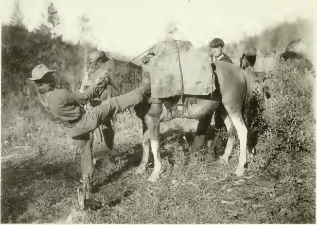
THIS “DIAMOND” HITCH KICK A STEEPER CLIMB
horses can sleep in the
natural shelters these localities afford.
Wheat is cultivated
chiefly in the vicinity of the Fraser valley: Okanagan, Spallumcheen and
in the Thompson River valley round Kamloops. So far oats is the grain
most cultivated.
Root crops are
prolific, especially at Chiliwack, and in the Okanagan district. These
districts, together with Agassiz, are adapted to hop growing. The crop
is disposed of for the most part in the British market. A new market is
rapidly opening up in New Zealand, in consequence of the fine specimens
sent to the international exhibitions in that colony.
Fodder crops chiefly
consist of red clover, timothy, alfalfa, alsike, sainfoin and brome
grass. All these thrive vigorously, and some of them yield three crops
in the season. Hay gives on an average about 1½ tons to the acre.
Tobacco grows freely in the south. It often realizes 7½d. a pound.
The success of
flowering bulbs in the vicinity of Victoria, which is peculiarly adapted
to this form of horticulture, has resulted in the establishment of a
large business there. The profits recorded amount to as much as £400 per
acre. Bee-keeping is naturally associated with horticulture. It is
becoming an important branch of farming, as honey finds a ready market.
It is evident that where flowers will grow in such luxuriant profusion,
bees will thrive.
Two problems which
heavily handicapped early settlers are now being practically solved. The
land-clearing difficulty, which entailed much labour, and postponed the
fruit of the soil, can now be effected by contract. Companies have been
formed for this purpose. The cost per acre is considerably reduced by
the disposal of the timber. The other question has been that of
irrigation and dyking. There are several low-lying districts in the
province which contain rich alluvial soil, but until an adequate dyking
system has been established these lands are unworkable. In the Fraser
Valley 100,000 acres have been reclaimed by the Government, and are now
ready for cultivation. In West Kootenay there is another tract of 40,000
acres, partly reclaimed, and already rewarding outlay.
In the higher grounds
of the southern interior, irrigation on the part of individuals is
well-nigh impossible. But a large portion of these lands has been taken
up by companies who are parcelling them out and constructing reservoirs
to ensure a constant water-supply. The result is satisfactory, and land
is being quickly disposed of and cultivated to advantage. There remain
yet many thousands of acres waiting to be reclaimed and turned into
orchards and farms.
In cattle-rearing there
are comparatively few of the very large ranches of earlier times. The
modern method has greatly improved the quality of the stock. A
Dairymen’s and Live Stock Association imports
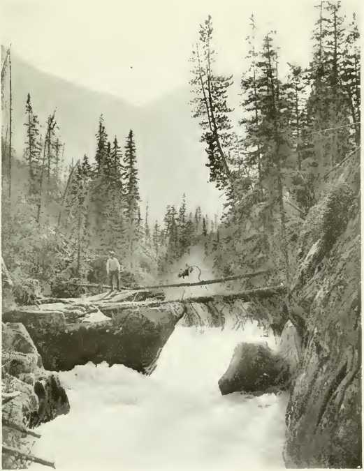
MOOSE RIVER FALLS
and sells well-bred
stock to its members, and cattle raising, even on a small scale, is
remunerative.
The southern half of
the province contains at least 1,000,000 acres of land suitable for
fruit growing. The Royal Horticultural Society’s gold medal was awarded
for a small exhibit in 1904. In 1905, British Columbian fruit took the
first prize in London, besides winning medals. Strawberries yielded
large crops, 4 acres producing as much as 28,126 lbs. Tokay grapes grow
in the open, averaging 4 lbs. to a bunch. Plums, cherries, peaches,
tomatoes, all do well. A cherry tree at Agassiz yielded 1000 lbs. of
fruit. I know of strawberries being sold in the city of Vancouver last
year at 6d. per pound. |


