|
ETOBICOKE Township,
situated at the south-west corner of the county, is irregular in shape,
and laid out in a fragmentary and unsystematic fashion. It fronts on
Lake Ontario, having the Humber river as its eastern boundary. Its
western limit is Etobicoke Creek and the Gore of Toronto in Peel County,
and to the north lies the Township of Vaughan. It comprises 29,540
acres, being, with the exception of North Gwillimbury, the smallest
township in the county. The northern portion, comprising about
two-thirds, is laid out in concessions running north and south, the
three western concessions being numbered, and the eastern ones known as
A, B, and C. The southern portion is broken up into smaller rows of
concessions, some numbered from west to east, and others running north
and south, in a very confusing manner.
The etymology of the
name Etobicoke is uncertain. It is usually supposed to be Indian, but on
the earliest documents it appears as Toby Cook." In the Crown Lands
Department there is preserved a map dated Newark, 1793, by Abraham
Iredell, Assistant Deputy Surveyor, upon which has been written the
following memorandum:—"The river Toby Cook is a rapid stream of water.
The land in the bottom good, but much cut to pieces with the high water.
On the rear boundary line from the river Toby Cook to the large stream
of water on lot 15, the land is very good. From, the stream to the north
angle is a burr and pine plain; from thence to the said stream, from the
stream to lot No. 9, burnt land, but tolerable good ; from thence to the
lake, good. The land west of the 100 acre lots on the line No. N, W. is
good to lot No. 7, but low land to No. 13, the other lots good." "Toby
Cook" appears to have been the customary spelling during the early days
of settlement, as it is seen on several other maps, but in 1811 the name
was given as it is now spelled, on an official plan, and since that time
"Etobicoke" has been the recognized etymology. As no such person as Toby
Cook is known either to history or tradition in connection with the
locality, it is altogether probable that the first surveyors or settlers
caught the Indian pronunciation imperfectly, and rendered it by this
homely appellation as a matter of convenience, the true derivation being
obscured by the spelling. The first settlement of the township took
place about the beginning of the century. In 1795 the "Militia lands"
were laid out by Surveyor Iredell. Part of the boundary was marked out
in 1797 by Mr. Augustus Jones. The following year a surveyor named
Hambly undertook the work of survey, which was continued at various
intervals by Messrs. Wilmot, Ridout, Hawkins and Castle, the latter
completing the laying out of the township in the year 1838.
The earliest settlers
of Etobicoke were the U. E. Loyalist refugees, who sought to build up
homes in the wilderness, whose strong arms and stout hearts subdued the
forest and dared the perils of an unknown and savage land. All honour to
their memory!' 'Those were indeed the times that tried men's souls."
Their descendants of to-day, in the midst off comfort and plenty,
surrounded by the blessings of civilization, can hardly even picture1 to
the imagination the rough and rude beginnings of our national greatness,
the unbroken forest north of the great lakes, the arrival of the few
travel-worn bands of emigrants whom the result of the revolutionary
struggle had left of home and possessions, often of their nearest and
dearest. Did men, whom cruel war had robbed of the sons whom they fondly
hoped would be the stay of their declining years^ widows and orphans,
youths barely grown to manhood, pushed out to battle with the perils and
vicissitudes of an unknown region, together with those in the prime and
vigour of maturer years, survivors of many a hard-fought field, who had
laid down the sword or musket to assume the implements of peaceful
industry and carve out homes and build up fortunes for themselves in the
Canadian wilds. Such were the original elements of our flourishing and
prosperous community.
I hear the tread of
pioneers
Of nations yet to be;
The first low wash of waves where soon
Shall roll a human sea.
They halt where the
land seems richest and the position most favorable and the forest echoes
are awakened with three ringing cheers for King George. Then follows the
bivouac around the camp fire, and the next day the woods ring to the
unaccustomed sound of the axe, and many a tall tree toppies to the
ground with a resounding crash, letting the sun stream down on the thick
underbrush through the ever-widening rifts m the canopy o green. Rude
log-huts are built with chimneys of unhewn stone without plaster, and a
single aperture to serve for door and window7. The first crop is sown on
the narrow clearing, thickly studded with stumps, and bounded on all
sides by the straight grey columns of the tree trunks, charred by the
burning of the brush heaps. Winter comes, and the pitiless storm drifts
the snow n between the chinks of the logs, and the howl of the wolves is
heard at nights. There is scant store of provisions, and the skill of
the hunter must supplement the shortness of the crop. There is sickness,
and accident, and death. Ofttimes the settler is crushed and mangled by
falling timber or prostrated by fever, and the medical appliances are of
the rudest. And so the stern contest with nature goes on until the
clearings widen and the forest retreats, until glimpses of the smoke
rising from adjoining cabins bring a sense of neighbourhood and closer
association. The old Indian trail through the bush is widened into a
wagon track. New waves of population follow. The original log cabins
give place to larger and more commodious structures. The itinerant
preacher comes along, and his visit is hailed with joy as a harbinger of
gospel privileges of which the settlers have so long been deprived. He
marries half a dozen waiting couples who have delayed their union for
perhaps years until such an opportunity should present itself, and
admits to the visible Church on earth as many young native Canadians,
the first-born of the settlement. It is a great day when a small church
of logs is erected, and a settled minister secured. And so here and
there population crystallizes around centres, the embryo towns and
villages, and the first struggles and perils and inconveniences of the
pioneers are over. These struggles, these hardships of which we, their
descendants or successors, reap the benefit in such ample measure,
should never be forgotten by Canadians.
One of the earliest
grantees in Etobicoke was Colonel Smith, of the Queen's Rangers, who
received a large tract of land which now forms the 4th and 5th
concessions of the southern portion of the township. Colonel Smith was
for some time President of the Province of Upper Canada. Gourlay, in his
"Statistical Account of Upper Canada," thus speaks of Colonel Smith's
homestead on the Lake shore, \n the neighbourhood of the River
Etobicoke:—"I shall describe the residence and neighbourhood of the
President of Upper Canada from remembrance, journeying past it on my way
to York from the westward by what is called the Pake Road, through
Etobicoke. For many miles not a house had appeared, when I came to that
of Col. Smith, lonely and desolate. It had once been genteel and
comfortable, but was now going to decay. A vista had been opened through
the woods towards Lake Ontario; but the riotous and dangling undergrowth
seemed threatening to retake possession from the Colonel of all that had
once been cleared, which was of narrow compass. How could a solitary
half-pay officer help himself settled down upon a block of land whose
very extent barred out the assistance and convenience of neighbours? Not
a living thing was to be seen around. How different it might be,
thought, were a hundred industrious families compactly settled here out
of the redundant population of England. The writer continues to narrate
how he lost his way in the woods, owing to the disappearance of the road
a short distance beyond the resident's house, in a bank of gravel thrown
up at the mouth of the Etobicoke. lie gave his horse the rein, and let
him take his own way. "Abundant time," he says, "was afforded for
reflection on the wretched state of property flung away on half-pay
officers. Here was the head man of the Province ' born to blush unseen,'
without even a tolerable bridle way b3tween him and the capital city,
after more than twenty years' possession of his domain. The very gravel
bed which caused me such turmoil might have made a turnpike, but what
can be done by a single hand? 'The President could do little with the
axe or wheelbarrow himself, and half-pay could employ but few labourers
at 3s. 6d. per day, with victuals and drink.
Colonel Smith, however,
showed a good deal of public spirit in some directions. He did something
towards improving the breed of horses, spending considerable amounts in
the importation of blood stock from the United States.
Among the original
patentees of Etobicoke were the following, their patents bearing date in
the respective years indicated :—
1798—Sergeant Patrick
Mealy.
1799—Thomas Tivy,
Joseph Hunt, James Hunt.
1800—James Crawford,
Thomas Moseley.
1801— Francis Bark,
Barnabas McGrevie, George Bender, Abraham Cameron, Christian Chisholrn.
Adam Baker, Jr., William Hooten, Francis Stevenson, John Doggert, Leah
T. Gamble, William Clarke, Ann Christie, Catherine Magdalen Gamble,
Eliza Christie, William Calder.
1802—Hon. Robert
Hamilton, John Gamble, Richard Wilson, S. Stevenson, A. Brigham, B.
William.
1803—Isaac Pokington,
Samuel Giles, Alexander Thomson, Michael Miller, Dan Paughlin.
1804—Robert Gray,
George McDonald, John Perry, Daniel Stewart, J. Doggert.
1805—Isaac Mitchell.
1806—Robert Richardson,
John Gould, John Claus, Samuel Smith, John Thorn.
1807—Andrew Morrow,
Gerhard Himck. Thomas 13. Gough, Moses Dewar, Dorothy Arnold.
1S09—Eleonora Moore,
Elizabeth Moore, L. Stevenson.
1810—Simcoe Stevenson,
Elizabeth Stevenson, Eleonora Stevenson, Harriet Hainer.
1811 William Halton,
Robert Gray.
1815—Sarah Powell, T.
II. Stevenson.
1817—Christopher Widmer.
Among others who also
received patents at an early date in the history of the township were
John Campbell, Caleb Humphrey, Edward Heazzel, John Vanzantee, Esther
Burden Davison, Joseph Shaw, George Gowland and Thomas Whitaker. The
Canada Company, King's College and Christ Church, also obtained
extensive grants.
No records of the
township meetings prior to 1850 have been preserved. At the first
meeting in that year, the township was divided into five wards. The
following were elected members of the Council by the meeting :—Moses
Appleby, Thomas Fisher, William Gamble, William B. Wadsworth and John
Geddes. At a subsequent meeting held on the 21st January, the Council
was organized by the election of William Gamble as Reeve, and William B.
Wadsworth as Deputy-Reeve. Edward Musson was afterwards chosen Township
Clerk. A report presented to the Council by Mr. Thomas J. Hodgkin,
Superintendent of Common Schools, shows that at this date there were
eight school sections in the township, in seven of which schools were
established. The report complains of defective school requisites. The
number of scholars on the roll between the ages of live and, sixteen
years was 333, besides ten above school age, two-thirds of the whole
number being boys. Only one of the schools was free. Of the scholars,
214 could write, 13 were studying French and 8 taking Latin lessons. The
expenditure of the year was as follows:—For bridges, £98. 11s. 4½d.;
printing and stationery, £21. 1s. 3½d.; school assessments, £179;
contingencies, £20. 13s. 7d.; salaries, £75. 6s. 11d.; school funds,
£89. 0s. 9d.; cash in hand, £179. 15s. 8½d.
In 1851, the Council
consisted of Moses Appleby, Alex. McFarlane, Andrew7 Ward, Joseph Smith
and John Geddes. Joseph Smith was elected Reeve, Andrew Ward,
Deputy-Reeve, and John R. Bagnell, Clerk and Treasurer. Mr. Smith
retained the Reeveship till 1855, m which year he was succeeded by
Alexander McFarlane, who in 1858 gave place to Edward Musson. The latter
occupied the position continuously for seven years until 1864. W. A.
Wallis and Matthew Canning are among those who have since held the
Reeveship. Andrew Ward first chosen Deputy-Reeve in 1851, retained that
office for five years, William M. Ross succeeding him in 1856, and
giving place to W. A. Wallis two years later. Since then the Deputy-Reeveship
has been filled by W. B. Wadsworth, Matthew Canning, W, Taylor, P.
Wardlaw, E. C. Fisher, Jonathan Orth, Robert Willcock, and others. In
1855, Joseph Dawson was chosen Township Clerk and Treasurer, being
succeeded by William R. Scott in 1861, who held the office for three
years. In 1864, Alexander McPherson was appointed and has filled the
position ever since. Tiie following are the principal municipal
officials for 1884: Matthew Canning, Islington, Reeve, J. D. Evans,
Islington. Deputy-Reeve ; Daniel F. Homer, Mimico, James Kellam,
High-field, and James A. Young, Weston. Councillors; Adam F. Mather,
Islington and John F. Hill, Weston, Assessors.
The soil of Etobicoke
consists of heavy clay, and clay loam, in the northern section, and
sandy loam and sand in the southern division, black loam being
distributed over the township. About 25 per cent, of the area is heavy
clay, eight inches deep, with an argillaceous subsoil. About equal
proportions consist respectively of clay loam, eleven inches in depth,
and sandy loam of the depth of one foot, with a clayey subsoil in both
cases. Perhaps 10 per cent, 's sand, and varying in depth, and 15 per
cent, black loam, two feet or so above a stratum of sand and clay. None
is too stony to interfere with remunerative cultivation, and only about
1 per cent, objectionably hilly in character. Ten per cent, is rolling
land, and the low flat land is not more than 2 per cent, of the total
area. An unusual proportion of the acreage of this township can be
classified as first-class land, four-fifths being of this quality; 10
per cent, is of second-class quality, and only 1 per cent., third-class.
Idle average price it will bring in the market for agricultural purposes
is $80 per acre for first-class, and $60 for second-class land. Hie
township is well watered, and where the springs and creeks do not
furnish a supply, water can be reached by digging at a depth varying
from 10 to 40 feet. Many of the farms are fenced in first-class style,
rail and board fences being the kinds most generally adopted.
Three-fourths of the dwellings and the outbuildings of the farms are
constructed of brick or stone, or rank as first-class frame buildings.
Drainage is not practised to any considerable extent, only 3 per cent,
of the farms being drained. Artificial fertilizers are in use upon about
one-tenth of the farms, plaster, salt and superphosphate being the kinds
generally employed.
The proportion of land
devoted to the staple crops is as follows: Fall wheat, 15 per cent.;
spring wheat, 5 per cent.; barley, 20 per cent.; oats, 10 per cent.;
peas, 5 per cent.; potatoes, 3 per cent.; turnips, 1 per cent.; other
root crops, 1 per cent., and hay 15 per cent. Twenty-two per cent, is
pasture land, which is a larger proportion than in any other township in
the county, and 3 per cent, devoted to fruit raising. The following is
the average yield per acre:—Fall wheat, 20 bushels; spring wheat, 15
bushels; barley, 30 bushels; oats, 40 bushels; peas, 20 bushels;
potatoes, 100 bushels; turnips, 300 bushels; other -root crops, -500
bushels; hay, a ton and a-half. A large proportion of the land is still
timbered; the woods consisting mainly of beech, maple, elm, basswood,
and pine. There are three flouring mills in the township. In 1881, the
number of cattle was, 1887; of horses, 1257; of sheep, 1277, and of
hogs, 826. A good deal of imported stock has been introduced. The breeds
of stock most extensively raised are draught horses, Durham grade, Devon
cattle, sheep of the Cotswold and Leicester breeds, and Suffolk and
Berkshire hogs.
In 1850, the population
of the township was 2,904—it contained five grist and seven saw mills,
and the crop returns for the previous year were: 82,000 bushels of
wheat, 16,000 bushels of barley, 41,000 bushels of oats, 20,000 bushels
of peas, 25,000 bushels of potatoes, 11,000 pounds of. wool, 4,000
pounds of cheese, and 24,000 pounds of butter. Since that time, the
population has been almost stationary. In 1871, the inhabitants numbered
2,985, and the census of 1881 gives the number at 2,976. Of this number,
2,137 were native Canadians. The number of occupiers of land was 425, of
whom 254 were the owners of the soil. The total area occupied amounted
to 28,527 acres, of which 24,801 was unproved land. The area in
cultivation for field crops included 19,435 acres—4,319 acres were
devoted to pasturage, and 1,047 to gardens and orchards.
The staple agricultural
products were returned as follows:—Wheat, 58,245 bushels; barley, 90,305
bushels; oats, 104,791 bushels; peas and beans, 15,766 bushels;
potatoes, 92,905 bushels; turnips, 50,000 bushels; other root crops,
41,705 bushels; hay, 5,394 tons.
A saw-mill was
constructed by the Government about the. year 1795 on the Etobicoke side
of the Humber, about two miles and a-half from the lake. The work was
done by a mill-wright named Nicholas Miller, who was brought from New
York State for the purpose. The mill, which was built partly of logs and
partly of boards, was run successfully by parties named Willson,
Cushman, and Stile Stephenson, who either rented it or were employed by
the Government, it is not certain which. About 1820 the mill and twelve
hundred acres of land were leased to Mr. Thomas Fisher at a low rent,
but he soon afterwards gave up the greater portion of the land. The mill
was purchased by Mr. William Gamble in 1835, and the year following he
erected on the site a stone flour-mill with six run of stones. The
supplies for the mill were carried up from the mouth of the river in
barges, and the flour shipped in the same way. Mr. Gamble afterwards
built a wharf and storehouse near the entrance of the Humber.
In 1835, a four-story
flour-mill was erected by Mr. Fisher on the Etobicoke side of the
present village of Lambton. It was partly stone and partly frame, and
was burned down in 1843. It was, however, rebuilt the following year,
and leased to the Howland brothers. The dam was washed away by a flood
in 1878. In 1880 the property was purchased by George Smith, who made
extensive additions, and fitted up the mill for the woollen manufacture.
Near this point a carding and fulling mill was constructed in 1820,
which underwent several changes in proprietorship as well as in the uses
to which it was put. Mr. James Williams was the owner about 1867, since
which time it has not been in operation. About a mile above Lambton a
saw-mill was erected by Samuel Scarlet, in 1854. It was destroyed by
fire six years later, but soon rebuilt. The property was purchased by
George Stonehouse in 1875. Haifa mile or so higher up stream John
Scarlet, father of Samuel Scarlet, put up a saw-mill, in 1831, and also
partly constructed two fiour-mills in the immediate neighbourhood. The
saw-mill and a quantity of adjacent land passed to his son Edward, and
in 1871 the mill became the property of Mr. Matthew Canning.
Market gardening is
carried on to a considerable extent in the southeastern portion of the
township, the markets of Toronto affording a ready sale for vegetables
and fruit. There are excellent railway facilities, especially in the
southern portion of the township. The Great Western branch of the Grand
Trunk runs within a short distance of the lake, east and west. It has a
station near the Village of Alimico, a pleasure resort about a mile and
a half west from the Humber, where many of the Torontonians have summer
residences. The spot is a favourite one for picnics and excursion
parties. At this point the Alimico River enters the lake, anil the
beauties of the scenery along its banks and in the neighbourhood of the
lake shore are greatly appreciated by pleasure-seekers.
The Credit Valley
Railway strikes the township at Lambton, about two miles north of the
Great Western branch, and traverses it in a southwesterly direction,
parallel for most of the distance with the Dundas Road. About a mile
from Lambton, on the Dundas Road, is the Village of Islington, where the
agricultural exhibitions of the township are held. Two miles further
west, partly in Etobicoke and partly in the adjoining Township of
Toronto, in Peel County, is the Village of Sumrnerville.
The main line of the
Grand Trunk runs west from Weston. The Toronto, Grey and Bruce Railway
runs northward from the latter point to within about a mile from the
northern boundary of the township, when it deflects to the north-west.
The principal villages in the northern portion of the township are
Clairville, in the extreme north-western angle; Smith-field, about two
miles to the south-east; and Thistletown, a mile and a-half further in
the same direction. These are all connected by a road running from
Weston northward for a mile or so, and then crossing the Humber and
running north-west to Clairville. Highfield is situated about a mile
from the western boundary, and a short distance north of the Grand Trunk
main line.
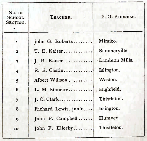
There are, in all, ten
public schools within the limits of the Township of Etobicoke. Their
respective situations are shown by the following table:—
 |


