|
In this chapter I
propose to treat of the resources of Her Majesty’s dominions in the
Pacific, comprising, as the reader already knows, the country between
the 49° and 54° 40' north latitude and the Rocky Mountains and Pacific
Ocean, Kith the islands of the coast comprised in those limits. In doing
so, I shall speak of the general condition of the country and its
probable future ; offering, at the same time, an account of the various
routes by which emigrants may reach it, with the approximate cost of
each. I shall also have occasion to speak of the routes that may
hereafter be opened up to the great gold-fields of the Pacific. In so
doing I shall not hesitate to avail myself of the information afforded
by Parliamentary papers, the labours of others, and the press; selecting
from these and more private sources such facts and suggestions as my own
experience of the country may lead me to approve.
The claims of the Hudson Bay Company to the possession of the territory
they have so long held by grants from the Crown, renewed from time to
time through a couple of centuries, have been so fully discussed in and
out of Parliament that it is needless for me now to enter upon this
subject. I think, however, that those who blame the Company’s rule do
not sufficiently consider the vast difficulties with which these traders
have had to contend. Living, as their assailants do, under the
protection of British law, they are little capable of appreciating the
absolute necessity of many apparently cruel acts, which however were
directly traceable to the instinct of self-preservation. I do not mean
for a moment to deny that there were acts of cruelty committed by the
Hudson Bay people, which even this consideration could not justify; hut
I do maintain that a handful of white men, hundreds of miles away from
the protection of their own flag, surrounded by a population, among whom
were many both fierce and treacherous, should not, in common justice, be
judged by the rules which apply to a more civilised state of existence.
One of the main charges against the officers of the Hudson Bay Company
in what was then Hew Caledonia is, that while their lease of the country
specified that offences above a certain degree should be tried by the
Courts of Canada, they, instead of sending criminals there, executed a
species of retaliatory justice themselves. But it was simply ridiculous
to expect any such slow and awkward machinery for the repression or
punishment of crime to be used. As it was, the Company, under that
instinct of self-preservation I have before put forward in their defence,
appointed the best men they had to the charge of them posts, and left
them to hold their own and maintain law and order among the Indians as
best they could. No one who has travelled much among the natives of
British Columbia can fail to be convinced that one result of the
Company’s rule has been that the white man is respected by them
everywhere. Even the missionaries —who complain of the little that has
been done during these many years for the spiritual welfare of the
Indian tribes— must admit that but for their familiarity with the
traders, and the opinion they have thereby gained of the honesty and
justice of the Englishman generally, their reception would be very
different to what it now is.
Again; the abuse which has been showered upon the long and undisturbed
monopoly of the trade of these regions enjoyed by the Hudson Bay Company
would have been more deserved had their possession of them been valued
or envied by others. As it was, the country was unheeded by emigrants,
neglected by the Government, and but for the Company’s tenure of it,
might have fallen into the hands of Russia, France, the United States,
or any other nation that cared to take it.
The time has undoubtedly come when their pretensions to its longer
possession should be rightly unheeded. But I think it should have been
resumed by the English Government with thanks for the Company’s care of
it, rather than with vague distrust and suspicion of their past
occupation. I for one feel convinced that I should have found it
impossible to travel about British Columbia with the ease and freedom
from danger which I felt, but for the influence of the Hudson Bay
Company exerted in my favour. The name of Mr. Douglas, as I have more
than once said, proved to be a talisman, wherever it was mentioned, that
secured me respect and help. The reports of Captain Palliser show also
that the success of his three years’ exploration in the Rocky Mountains
was owing, in no small degree, to the influence and assistance rendered
him by the Company. The following extract from one of his despatches
will, I think, serve to illustrate this sufficiently. One of a
deputation of Indians who waited upon him, an old chief, spoke thus:—
“I do not ask for presents, although I am poor and my people are hungry.
But I know that you have come straight from the great country, and we
know that no man from that country ever came to us and lied. I want you
to declare to us truthfully what the great Queen of your country intends
to do to us when she takes the country from the Fur Company’s people.
All around I see the smoke of the white men to arise. The Longknives
(Americans) are trading with our neighbours for their land, and they are
cheating and deceiving them.”
Who but the officers and men of this much-abused Company could have
inspired this spokesman of the Indian people with the trust in the word
of an Englishman which is here expressed?
Again; any one who knows the condition of the Indians in British
Columbia, and will take the trouble to compare it with that of the
tribes in American territory, must come to the conclusion that some
salutary influences—wanting there —have been at work among them.
Scarcely a paper reaches Victoria from Oregon or Washington states that
docs not contain an account of some brutal murder of whites by the
Indians, or some retaliatory deed of blood by the troops of the United
States. So confirmed, indeed, has their enmity become, that what is
little short of a policy of extermination is being pursued towards the
Aborigines.
But in British Columbia troops have not once been called upon to oppose
the Indians; and men of every class, from the Bishop on his visitation
to the friendless miner, travel among them in confidence and unmolested.
While, therefore, quite prepared to admit that in their government of
the country the Hudson Bay Company have been guilty of sins both of
commission and omission, I cannot, in common justice, forbear from
stating the good they have actually accomplished in British Columbia.
With respect to the routes to British Columbia, there are at present
five open :—
1st. By the Royal West India mail-steamers to Aspinwall, across the
Isthmus of Panama, and thence by American packets to San Francisco and
Victoria.
2nd. By the Cunard steamers to New York, and thence by American steamer
to Aspinwall; the rest of this route being by the same conveyance as the
last.
3rd. Round Cape Horn, or through Magellan Straits, and thence direct to
Victoria by the same ship all the way.
4th. Across the American continent, from Lake Superior or St. Paul’s to
Red River, and thence over the Rocky Mountains. Or, perhaps, it would be
better to say across the continent in British territory, as there are
several ways by which this may be done. And—
5th. Across the continent in American territory to California, and
thence by steamer to Victoria; or by land to Portland, in Oregon, and
from there by steamer to Victoria.
By the first of these routes the total expense of the journey may be
estimated at 90l. for first class, proportionately less of course for
second and third; the time occupied, if there are no delays on the way,
being under six weeks. Adopting this route, the traveller may embark at
Southampton on the 1st or 16th of any month, and Proceed direct to St.
Thomas, a passage of 12 or 14 days. At St. Thomas he takes an
intercolonial steamer, and in four to six days reaches Aspin-wall, the
port on this side of the Isthmus of Panama. Crossing the Isthmus by
rail, in oh hours Panama is reached. Here the great drawback to this
route is often experienced in the fact that there is no certainty of
finding a Pacific steamer ready to sail, and that very often the
traveller has to stop at Panama a week or ten days before one starts.
This delay, of course, adds considerably to the expense of the journey,
to say nothing of Panama being a most unhealthy place to stay in.
Arrangements, however, are said to be making to remedy this
inconvenience.
The passage to San Francisco occupies 14 or 15 days, and on the way the
steamer calls at Acapulco for coal. Arrived at San Francisco a further
delay takes place, and it is sometimes a week or ten days before the
steamer for Victoria leaves. Some arrangement has, I believe, lately
been entered into, however, which has made the line between San
Francisco and Victoria more regular.
By the second route the latter half of the journey is the same as the
first, the difference being that the traveller starts by the Cunard
steamer from Liverpool for New York.
At New York the traveller may have to stay a few days, but this is
better thau waiting at Panama, and then he goes to Aspinwall in a
regular line of American packets: the great advantage of this line being
that it is connected with the Pacific Mail Company’s steamers to San
Francisco, and therefore there is no chance of being—unless, indeed, the
Atlantic packet brings more passengers than the Pacific one can carry
away—kept eight or ten days 011 the Isthmus.
The third route is, by the old way, round Cape Horn, or through the
Straits of Magellan. The drawback to this is the length of the
sea-voyage, which may be said to average five months, although it has
been done in four. The Hudson Bay barque, ‘Princess Royal,’ has for
years made a yearly trip out and home, leaving England in the autumn,
reaching Victoria in January 01* February, and returning home again by
the end of June. She still bears the palm for quick passages. Captain
Trivett, who has commanded her for years, says his great object always
is to get out well to westward after passing Cape Horn, not caring if he
have to go somewhat to southward in doing so, by which he finds he gains
greatly on those who fear getting too far westward, and hug the coast
rather than stretch far out. His quickest passages have been 118 days
out and 110 days home; his average of five passages out 133 days. This
route is by far the cheapest yet open, and indeed may be said to be the
only one within the reach of the poorer class of emigrants. The cost
varies considerably, but will get cheaper as passengers become more
numerous. The Hudson Bay Company’s charge has always been 70l, for first
class and 30l. for second class. Their charges for freight also have
always been high also, but vessels are constantly advertised to sail by
first-rate firms; and a line of clipper ships of 1200 tons is announced
to carry passengers at more moderate rates.
The fourth way lies across our own part of the continent. This route
must be for some time virtually impassable. The. fate of those emigrants
who, deluded by the misrepresentations of the bubble British Columbian
Overland Transit Company, started to make a supposed easy journey from
St. Paul’s across the Rocky Mountains, must still be fresh in the
recollection of my readers. The inducements held out by the so-called
Company, calculated as they undoubtedly were to deceive the public
generally, could impose upon no one who had any practical experience of
the country. For instance, one of their statements was, that above 1000
carts travelled annually along the line they proposed to follow. The
impression conveyed by this is that these carts crossed the Rocky
Mountains into British Columbia by the route proposed to be taken by the
Company; whereas the truth is, that they simply trade to the Red River
and the Saskatchewan country, and no further. That a waggon-road will
some day be carried over the passes of the Rocky Mountains that lie
beyond the Red River settlement, and between that point and British
Columbia, I have no doubt. It may be, indeed, that before very long the
whistle of the locomotive will be heard among them. But that as yet they
are impassable for waggons, and that they present great, and at times
almost insurmountable, difficulty to all save the experienced
unincumbered traveller, the following quotations from the reports of
Captains Palliser and Blakiston and Dr. Hector will, I think, be found
to contain conclusive proof.
It will assist the reader in forming a judgment upon this matter if I
first give, from the report of Captain Blakiston, an account of the
passes of the Rocky Mountains by which British Columbia may be reached.
“In anticipation,” writes Captain Blakiston, “of the establishment of a
continuous route through British North America, it is proper here to
refer to the passes of the Rocky Mountains north of latitude 49, or, in
other words, in British territory. There are many points at which the
chain of these mountains can be traversed; but omitting for the present
that known as ‘ Peel’s River Pass,’ within the Arctic circle, and that
from Fraser Lake to Pelly
Banks, at the head-waters of the Youkon in latitude 62°, as well as one
from Cease’s House to Stickeen, and others only known to the hardy
fur-traders of the far north, we come to three: one of which crosses
from the Findlay branch of the Peace River to Babine River, the northern
boundary of the province of Columbia; while the other two, at the very
headwaters of Peace River, in latitude 55° north, connect with Fraser
River at its most northern bend, one of which was described, as long ago
as 1793, by that intrepid traveller, Sir Alexander Mackenzie. The
connection with these being, however, by water, and rather far north on
the east side, 1 shall pass on to enumerate the known passes more to the
southward, and which may be called the passes to British Columbia. In
commencing with the North, they stand thus:—
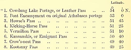
The first of these
connects the head-waters of Athabasca River with the great fork of the
Fraser, and has never been used except as a portage between these two
rivers.
“2. The second is that which, until the last few years, was used
regularly by the Hudson Bay Company for the conveyance of a few furs, as
well as despatches and servants, from the east side to the Pacific, by
the way of the Columbia River, and which, from the ‘ Boat Encampment,’
is navigable for small craft; but this, like the first, has not been
used in connection with any laud-route on the west side.
“3. The third was probably first used by either Thompson or Howse
(author of the Cree grammar), who, following up the north branch of the
Saskatchewan, crossed the watershed of the mountains to the north fork
of the Columbia, and thence to its source, the Columbia Lakes, where,
striking the Kootonay River, he followed it down to the south of 49°
north.
“4. The ‘Kicking-Horse Pass,’ so named by Dr. Hector, crosses the
watershed from near the head-waters of the Dow Diver to those of the
Kootonay, and may be reached by following up either the north or south
branches of the Saskatchewan by land.
“5. While another (see Parliamentary Papers, June 1859), the ‘Vermilion
Pass,’ likewise traversed and laid down by Dr. Hector during the summer
of 1858, occurs also on Bow River so near the last-named one, that it is
unfortunate that the western edge of the mountains was not reached, as
it would then have proved whether these passes can be of value in
connection with a continuous route across the country.
“6. The next pass which enters the mountains in common with the fifth on
Dow Diver, has been named the 'Kananaskis Pass’ (see Parliamentary
Papers, June 1859), and was laid down by latitude and longitude
observations during the summer of 1858 by Captain Palliser. This also
leads to the Kootonay River, passing near the Columbia Lakes. It is
generally supposed that this pass was only discovered last year, but a
description of it is to be found in £ An Overland Journey Round the
World,’ by Sir George Simpson, who, together with a party of emigrants,
50 in number, under the late 5Ir. James Sinclair, passed through, but
not with carts, as had been stated, to the lower part of the Columbia in
1841, besides which it has been used by other travellers. If we are to
consider its western extremity to the south of the Columbia Lakes, it is
a long and indirect route, but as yet it has only been used for
following the valley of the Kootonay, and thence into American
territory. In the event of the country west of the Columbia Lakes
proving suitable for a land-road, this, as well as the previous three,
would prove available for crossing from the Saskatchewan north of
latitude 51°.
“For 100 geographical miles of the mountains south of Bow River no pass
is at present known to exist until we come to the Mocowans, or Belly
River, a tributary of the Saskatchewan, on the branches of winch four
passes enter the mountains—the ‘Crow-nest,’ the ‘Kootonay,’ the
‘Boundary,’ and the ‘Flathead.’
“7. Of the first of these, we know only that its eastern entrance is on
the river of the same name, and that it emerges in the vicinity of the
Steeples, or Mount Deception, while neither of the two last are entirely
in British territory— hence the name of ‘Boundary Pass' for that which
has its culminating point north of 49°.
“8. The ‘Kootonay Pass,’ is the most southern, and, of those yet known,
by far the shortest in British territory.
“These passes, of which the altitudes are known, do not differ greatly;
and I refrain from commenting on their relative merits, because before
any particular one can he selected for the construction of a road, the
easiest land-route from Hope and the western bend of the Fraser River
should be ascertained, which, considering the distance, would be no very
great undertaking. In conclusion, I would only remark, that at present
no pass in British territory is practicable for wheeled-carriages.”
It should be remembered that Captain Blakiston wrote this before an
overland route was thought of. But he has since told me, that during his
explorations he came upon the remains of the waggons of Mr. Sinclair’s
party upon this side of the mountains, the idea of transporting them
farther having been abandoned at that spot.
Dr. Hector, t he geologist accompanying Captain Palliser’s expedition,
upon reaching the Rocky Mountain house, in the most northerly of the
passes enumerated above, writes of it thus: “The mountain-house is at a
distance of not less than 100 miles from the main chain of the Rocky
Mountains, which are nevertheless distinctly seen from it as a chain of
snow-clad peaks. The principal chain is, however, screened by a nearer
range, distant about 45 miles......I made an attempt to reach this near
range, but failed in forcing a road through the dense pine-wood with
which the whole country is covered.’"
Of the Kananaskis Pass, the sixth of the above list, Captain Palliser
writes thus: “On the 18th of August I started to seek for the new pass
across the Rocky Mountains, proceeding up the north side of the
Saskatchewan or Bow River, passing the mouth of the Kananaskis River;
five miles higher lip we crossed the Bow River, and entered a ravine. We
fell upon Kananaskis River, and travelled up in a southwesterly
direction, and the following day reached the Kananaskis Prairie, known
to the Indians as the place ‘where Kananaskis was skinned but not
killed.’ On the 21st we passed two lakes about two miles long and one
wide. We continued our course, winding through this gorge in the
mountains among cliffs of a tremendous height, yet our onward progress
was not impeded by obstacles of any consequence; the only difficulty we
experienced was occasioned by quantities of fallen timber caused by
fires......On the 22nd August we reached the height of land between the
waters of Kananaskis River and a new river, a tributary of the Kootonay
River. Our height above Bow Fort was now 1885 feet, or 5985 feet above
the sea. Next morning we commenced our descent, and for the first time
were obliged to get off and walk, leading our horses down a precipitous
slope of 960 feet over loose angular fragments of rock. This portion of
our route continued for several days through dense masses of fallen
timber, destroyed by fire, where our progress was very slow—NOT owing to
any difficulty of the mountains, but on account of the fallen timber,
which we had first to climb over and then to chop through to enable our
horses to step or jump over it. We continued at this work from daybreak
till night, and even by moonlight, and reached the Columbia Portage on
the 27tli of August.
“On September the 6th I started to recross these mountains by the
Kootonay Pass (the eighth upon the above list). This is frequently used,
but not the general pass of the Kootonay Indians, who have a preferable
one in American territory.
“On the 7th of September we passed the height of land—a formidable
ascent, where we had to walk and lead the horses for two hours. This is
the height of land which constitutes the watershed. We encamped for the
night in a small prairie after making a considerable descent.
“On the 8th of September our course continued through woods and swamps,
for about 15 miles, till we reached another ascent. This was also a
severe ascent, though not so formidable as that of the day previous; we
reached its summit about four o’clock through a severe snow-storm (this
in September), the snow falling so fast as to make me very apprehensive
of losing the track. We descended that evening, and camped on the
eastern side, and next day arrived at the eastern extremity of the pass.
I regret that I cannot give the altitudes of this pass, as our barometer
was broken by one of the horses. It is, however, far from being so
favourable as the more northern, by which I entered on Kananaskis River,
which has but one obstacle, in the height of land, to overcome, and
where the whole line is free from swamps and marshes.”
Dr. Hector, accompanying the same expedition, in speaking of the
Vermilion Pass (the fifth upon the list), says of it: “On the 20th I
crossed Bow River without swimming the horses or unloading the packs,
and, after six hours’ march through thick woods, reached the height of
land the same afternoon. The ascent to the watershed from the
Saskatchewan is hardly perceptible to the traveller who is prepared for
a tremendous climb, by which to reach the dividing ridge of the Rocky
Mountains; and no labour would be required, except that of hewing
timber, to construct an easy road for carts, by which it might be
attained.”
Of the Beaver or Kicking-Horse Pass (fourth upon our list), he says:
“The bottom of the valley (that of the Koutanay River) is occupied by so
much morass, that we were obliged to keep along the slope, although the
fallen timber rendered it very tedious work, and severe for our poor
horses, that now had their legs covered with cuts and bruises.
On the 31st of August we struck the valley of the Kicking-Horse River,
travelling as fast as we could get our jaded horses to go and as I could
bear the motion [he had been badly kicked by a horse]. On the 2nd Sept.
we reached the height of land. In doing so we ascended 2021 feet. Unlike
the Vermilion River, the Kicking-Horge River, although rapid, descends
more by a succession of falls than by a gradual slope. Just before we
attained the height of land, ive ascended more than 1000 feet in about a
mile, down which the stream leaps in a succession of cascades.”
I cannot do better than conclude the consideration of this question of
an overland passage to British Columbia with the following extract from
the Report of Captain Palliser to the Secretary of State for the
Colonies, in 1859
“In answer to the third query contained in your Lordship’s letter, viz.,
‘What means of access exist for British immigrants to reach this
settlement?’ I think there are no means to be recommended save those via
the United States. The direct route from England via York Factory
(Hudson’s Bay), and also that from Canada via Lake Superior, are too
tedious, difficult, and expensive for the generality of settlers. The
manner in which natural obstacles have isolated the country from all
other British possessions in the East is a matter of considerable
weight; indeed it is the obstacle of the country, and one, I fear,
almost beyond the remedies of art. The egress and ingress to the
settlement from the east is obviously by the Bed Biver valley and
through the States.”
Further on the same subject Captain Blakiston writes: “In answer to the
fourth query contained in your Lordship’s letter, viz., ‘Whether,
judging from the explorations you have already made, the country
presents such facilities for the construction of a railway as would at
some period, though possibly a remote one, encourage Her Majesty’s
Government in the belief that such an undertaking, between the Atlantic
and Pacific Oceans, could ever be accomplished?’ I have no hesitation in
saying that no obstacles exist to the construction of a railway from Red
River to the eastern base of the Rocky Mountains; and probably the best
route would be found in the neighbourhood of the south branch of the
Saskatchewan. An amount of capital very small in proportion to the
territory to be crossed would be sufficient to accomplish the
undertaking so far; but the continuation of a railway across the Rocky
Mountains would doubtless require a considerable outlay.
“In my letter to Her Majesty’s Government, dated 7th Oct., 1858, I have
referred to two passes examined by myself and Mr. Sullivan, my
secretary, both of which I found practicable for horses right across the
chain of the Rocky Mountains to the Columbia River, and that a small
outlay would render the more northern one practicable for carts, and
even waggons.
“On the return of Dr. Hector from his branch expedition, I found he had
also crossed the mountains as far as the valley of the Columbia River,
by the Vermilion Pass, which leaves the valley of the Bow River nearer
to its source than the pass I had myself traversed. In that pass he had
observed a peculiarity which distinguishes it from the others we had
examined, viz., the absence of any abrupt step at the commencement of
the descent to the west, both ascent and descent being gradual. This,
combined with the low altitude of the greatest elevation passed over,
led him to report very favourably upon the facilities of this pass for
the clearing of a waggon-road; and even that the project of a railroad
by this route across the Rocky Mountains might be reasonably
entertained.”
Before taking leave of this subject, I think it but right to correct
another impression which appears likely to mislead the public. This is,
that the quantity of buffalo on the route proposed to be taken by the
bubble Overland Transit Company is so great as to render it impossible
for a man with a gun in his hand to starve. Now, although enormous herds
of buffaloes may be met with indeed Captain Palliser writes of them,
“The whole region as far as the eye could reach was covered with
buffaloes in bands varying from hundreds to thousands”—yet it is quite
possible for the traveller to die of slow starvation and exhaustion
without seeing one. Dr. Rae, the eminent Arctic traveller, informed me
that he spent three weeks in these plains with a party of gentlemen, and
that during that time they saw nothing larger than a beaver, and only
shot two. martens!
Again we have seen that Dr. Hector was glad to travel 21 out of 24 hours
for want of food; and in a letter of Captain Falliser, written in the
midsummer of 1858, he says: “On my arrival at the Bow Fort, I found my
hunters waiting for me. They had been out in every direction, but could
not fall in with buffalo. They had also found elk and deer very scarce.”
In the same letter we also find him writing: “Owing to the absence of
buffalo during the winter, my hunters, as well as those belonging to the
Fort, have had to go to great distances in order to get meat, which they
obtained in such small quantities, that the Hudson Bay Company’s officer
in charge of this post was obliged to scatter the men, with their
families, all over the plains in search of food. Even Dr. Hector and Mr.
Sullivan were obliged to leave this post and go to Forts Pitt and
Edmonton in order to lessen the consumption of meat, of which the supply
there was quite inadequate. Fortunately, however, the winter has been an
unusually mild one, otherwise the consequences might have been very
serious indeed.”
Speaking of the mountains on the west side, Captain Palliser also
remarks: “The fact is, the knowledge the Indians possess of the
mountains is very small; and even among those said to 'know the
mountains,’ their knowledge is very limited indeed. This is easily
accounted for by the scarcity of the game, which offers no inducement
for the Indians to go there.”
Dr. Hector also writes: “While traversing this valley, since coming on
the Kootanie River, we have had no trail to follow, and it did not seem
to have been frequented by Indians for years. This makes the absence of
game all the more extraordinary. The only animal which seemed to occur
at all was the panther. The Indians saw one; and in the evening we heard
them calling, as they skirted round our camp, attracted by the smell.”
To this testimony of others, I may add my own experience. I have
travelled 600 miles in British Columbia without seeing anything larger
than grouse, or having the chance of more than half-a-dozen shots at
them. I have also had occasion to speak of death by starvation among the
Indians. This has been by no means uncommon of late, since they have
neglected the culture of their land for the more alluring search after
gold. If, then, the native of these plains finds it impossible to
support life upon the wild animals frequenting it, what chance, under
similar circumstances, could the artisan or the peasant, fresh from the
loom or plough, be expected to have?
The last of the routes which I have to consider is that across the
continent in American territory. A way between New York and San
Francisco has been for some time open, and so regular and speedy is the
transmission of mails by it, that the American postal subsidy has been
taken away from the Panama Steam Company, and given to the Overland. The
traveller by this route proceeds by rail to St. Louis on the border of
Illinois and Missouri. Thence by stage across Missouri to St. Joseph, by
the Missouri River to Omaha city, and from there across Nebraska and
Utah to the Great Salt Lake city. From Utah the route passes southward
of the Humboldt Mountains to Carson city and into California. A
telegraph now runs along the whole of this line, while a stage-coach
goes three times and the pony-express twice a week—the latter making the
journey in about seventeen days. The whole distance from New York to San
Francisco is about 8000 miles, of which 900 are travelled over by rail.
From San Francisco the traveller can reach his destination by land
through California and Oregon to Portland, and thence by steamer to
Victoria: or via the Columbia River to Walla-Walla and thence through
Okanagan across to the Thompson River, and so direct to the mines. This
route across the continent is considered pretty safe, and I know a lady
who crossed by it; but the mails are sometimes waylaid by Indians, and
the passengers murdered or ill-treated.
Before treating of the mineral resources of British Columbia, I wall
endeavour to describe its physical aspect. The coast of British Columbia
is fringed with dense forest, sometimes growing on low ground, but
generally covering mountain-ridges of all shapes, which terminate in
numbers of irregular peaks shooting up in every possible form and in
heights varying from 1000 to 10,000 feet. All these ridges and peaks
have the same general appearance, being composed of trappean or granitic
rocks and covered with pine-trees to the height of 3000 or 4000 feet,
and sometimes higher. Here and there the constant fires caused by the
carelessness of the Indians have stripped the branches from all the
trees on a hill-side, leaving nothing but scorched trunks standing on
the blackened rock; while in other places they appear stripped in the
same way from top to bottom of a mountain, the whiteness of the trunk,
however, forbidding the notion of fire. The reason of this phenomenon,
which was of frequent occurrence in the inlets, caused us much
speculation. The conclusion arrived at was, that it was caused by a
slide of frozen snow from the mountain’s summit. These mountain-ridges
are divided at intervals all along the coast by the long inlets of which
I have before spoken.
Behind all these minor ranges and inland of the heads of the inlets, the
Cascade Range rims nearly parallel with the coast, and at a distance of
60 to 100 miles from it, forming a barrier but too effectual to shut out
intruders into the Eldorado that lies beyond it. The highest peak of
this range is Mount Baker, situated hi latitude 48° 44' N. and
consequently upon American territory. Its height is 10,700 feet, and it
forms a prominent feature in the view from any part of the Strait of
Fuca or Gulf of Georgia. Though, as I have mentioned when describing the
inlets of the coast, there is usually a valley, sometimes of
considerable extent, at the head of these sea-arms, the Cascade
Mountains, as far as explorations have yet been carried, appear always
to bar approach to the country beyond. Sometimes they recede from the
coast so much that it is possible to steam 40 or 50 miles inland; but in
time the mountains are sure to be found closing in and barring farther
progress. The valley of the Fraser River forms the single exception to
this rule. Here the river has certainly mastered the rocks, and,
attacking them from the rear, cut itself a devious way to the sea. But
it has done no more, the rocks so closing in upon its course that, as in
the canons I have described, there is hardly footing left for a goat
along the high precipitous banks.
These coast-mountains have as yet been imperfectly examined, and little
therefore is known of their geological formation or mineral resources.
Hr. Wood, who, it will be remembered, accompanied me on my excursion
inland from Jervis Inlet, says of those we passed on that occasion, “On
the right side of the upper arm of Jervis Inlet the mountains, against
whose sides the sea washes, give indications of being composed of
porphyritic granite; the granite rocks generally are deeply imbued with
copper oxides; their veins of white quartz are frequently seen
intersecting the granite. The rocks forming the sides of the second
inlet, some six or eight miles distant, are more rugged and precipitous,
and consist generally of a strongly micaceous quartzose granite. A
mountain-stream which we crossed, presented in the granite and trap
boulders, which formed its bed, singularly rich specimens of iron
pyrites without any observable indications of other metals. Upon another
mountainous stream which we crossed, I saw the largest boulder of quartz
(transported) I ever witnessed; it must have been four or five tons’
weight, and was deeply stained on one side with oxides of iron.” During
this journey, I perceived indications of nothing but trap and granite,
with here and there thin veins of quartz. Indeed, I may say, that all
the inlets surveyed by the ‘Plumper’ presented the same geological
characteristics. Texhada Island, which lies off the entrance of Jervis
Inlet, is, however, an exception: nearly the whole of the northern end
being limestone, mostly blue, but some white and comparatively soft; the
blue being very hard. I found a few small outcrops of limestone in the
entrance of Jervis Inlet afterwards, but they were only thin veins,
round which the igneous rock had hardened. Clay-slate frequently occurs
in the inlets, but usually in very small outcrops. I have remarked its
occurrence also in the canons of the Fraser River, and Lieut. Palmer,
ILL. when in the same range (Cascade) on the Harrison-Lilloett route,
says, “From the cursory view I was enabled to take of the general
geological character of the country, trappean rocks appear to prevail,
consisting principally of greenstone, dense clay-slate (here and there
presenting a laminated structure), and compact hornblende. The exposed
surfaces of the rocks are generally covered with felspar, and are
occasionally stained red with iron, forming an agreeable contrast in the
landscape. Quartz-veins permeate the clay-slate in many places, of an
average thickness of one to twelve inches; the formation, in fact, would
suggest the high probability of metalliferous deposits. The mountains
rise bold, rugged, and abrupt, with occasional benches on their sides,
on which are found quantities of worn rounded boulders, principally of
coarse-grained granite, occasionally porphyritic. The granite contains
golden-coloured and black mica in large quantities. The crystals of
felspar in the porphyritic granite are very numerous, but small. The
soil appears in many places to have been formed by the decomposition of
granite, it being light and sandy and containing much mica.
“Below the soil is very generally found a white compact mass, very hard
and approaching to a conglomerate, containing pebbles of every
description in a matrix of decomposed clay-slate. Lime seems wanting
even in the conglomerate, and I saw no traces of limestone or sandstone
all along the route, though I understand there is plenty of the former
at Pavilion.”
Along the coast, between Jervis Inlet and Desolation Sound, the
appearance of the rocks changes somewhat, and quartz and slate
predominate.
Speaking of Desolation Sound, Mr. Downie says, “This is the first time I
have seen pure veins of sulphuret of iron, which looks very much like
silver. I came across a number of seams of the same kind; it lies in
quartz, the same as gold. I have no idea that the gold is confined to
the Fraser River alone; and if it can only be found from the seaboard,
or on the rivers at the head of some of these inlets, the country will
soon be prospected.” At the head of the same inlet, he says, “ I have
seen more black sand here in half a day than I did in California in nine
years; it looks clear and bright, as if it came from quartz.” f Seeing
it was out of the question to proceed farther, we put back, and came
down along shore, breaking and trying the rocks, finding much iron
pyrites and sulphuret of iron, but no gold.
In Knight’s Inlet I have mentioned plumbago as having been found; and on
Queen Charlotte’s Island (which may be regarded, in common with the rest
of these islands, as chips off the coast), gold-bearing quartz and coal.
Of the geological features of the interior little is yet known. Wherever
I have been, the same trappean rocks predominate as on the coast, except
at and around Pavilion, 220 miles up the Fraser, where limestone occurs
in large quantities. In the Cariboo district Mr. Hind, the Gold
Commissioner, says lie has observed “masses of quartz;” and when
travelling near the Antler Creek, in the valley of which some of the
richest diggings occur, he says, “The streams I passed were very
numerous; and where it was possible, from the falling in of the ice and
snow, to observe their beds, I noticed the same characteristics of large
quartz boulders and a kind of slate-rock, covered with red gravel, said
to bear a close resemblance to the rich auriferous beds of the streams
of the southern mines of California.
Of the Semilkameen district, in the southern part of the colony,
Lieutenant Palmer, R.E., in his Report quoted before, writes:—“The
geological character of the several districts (Fort Hope and Fort
Colville) is throughout very uniform, the rocks belonging principally to
the igneous and metamorphic series. The bulk of Hanson Mountain appears
to be granite, tipped with slate; here and there presenting particles of
white indurated clay, found, on examination, to contain fragments of
white quartz.
“This formation may be said to consist of granite, with its felspar
decomposed and reduced to a state of indurated clay; it extends to the
dividing ridge of the Cascades, and partly into the valley of the
Tulameen. In the latter valley may be seen vast masses of white quartz;
in all probability the exposed face of the rock, which, with granite,
constitutes a large portion of the district, extending into the
Semilkameen valley.
“On approaching the summit of the Tulameen range, the quartz partially
disappears, and is replaced by a species of variegated sandstone, in
which traces of iron occur. To what extent the sandstone prevailed I had
no opportunity of judging, the weather being snowy while I was there,
and the rocks, as a rule, imbedded in peaty turf.
“As we leave the Tulameen Mountains, and descend into the valley below,
indurated clay appears to predominate to a considerable extent. This
clay varies in character as we approach the Vermilion Forks; a portion I
noticed near that point being a white silicate of alumina mixed with
sand. On one specimen which I picked up were the fossil remains of the
leaves of the hemlock.
“Further down, in the Semilkameen valley, the clay acquires a slaty
texture, and becomes stained with iron, to a greater or less extent.
Blue clay also exists, only, however, in small quantities.
“The mountains bordering the Semilkameen consist chiefly of granite,
greenstone, and quartz, capped with blue and browui clay-slate. The beds
of both the Tulameen and Semilkameen are covered with boulders of
granite, of every description and colour; of greenstone and of trap, and
vary in form and size.
“Boulders of the same character prevail on the river-bottoms, to a
greater or less extent. Like that of most of the other explored parts of
British Columbia, the geological character of this region appears to
indicate the high probability of auriferous deposits. In the lower
portion of the Semilkameen, and near the ‘Big Bend,’ gold was discovered
shortly after I passed through, by some of the men attached to the
United States Boundary Commission. Beport pronounced the discovery a
valuable one, as much as 40 dollars to the hand being taken out in three
hours, without proper mining-tools; but I cannot speak positively as to
the truth of this statement, neither could I discover whether the place
spoken of was in British or American possessions. Probability would
suggest the former. Beyond Osoyoos Lake I did not deem it necessary to
pay much attention to the geological character of the country, the route
lying almost entirely in American possessions. Suffice it to say that
but few features of interest presented themselves, and that in no place
did I see any sign of stratified rocks.”
The only part of the country which can be said to have been geologically
surveyed, is the neighbourhood of the Harrison Lake and the portage
which lies between Port Douglas and Lilloett. In the summer of 1860, Dr.
Forbes, of H.M.S. ‘Topaze,’ undertook this service; and his Report
contains, among other things, much valuable information as to the
existence of silver there. Of the Harrison Lake, he says: “At the mouth
of the stream (on the east side of the lake) and extending on both sides
along the shore of the lake, were water-worn boulders of granitic and
quartzose rocks; gneiss, with garnets; mica-schist, with garnets; pieces
of good roofing-slate, together with masses of a pure white quartz,
containing excellent indications of metal. The mountain, the top of
which is somewhat rounded in its outline, having a flat surface to the
westward, and a remarkable pinnacle or finger-like rock at its immediate
base, is composed of trap; having resting upon it, and tilted at a high
angle, micaceous, talcose, and horn-blendic schists, all highly charged
with iron, the oxidation of which has produced disintegration of these
rocks. At a point 500 yards from the mouth of the stream, on its proper
right bank, a mass of trachytic rock has been erupted, shattering the
surrounding rocks, itself much shaken and shattered; great masses,
dislodged by weather and other causes, having slipped and rolled to the
bottom of the ravine.
“In this rock, of volcanic origin, was found a mass of quartz, of a
beautiful white colour, containing good indications of silver and
copper; which indications proved true, for, on assaying a specimen by
the reducing process, a globule of each of these metals showed itself.
The mass or vein of quartz dips northerly, beneath the overlying
trachytic rocks. It is wedge-shaped, the thickness increasing with the
depth. From it, in all directions, radiate veins of quartz; which,
guarded on each side by a fissile rock, of a French-grey colour,
permeate the mass of trachyte in all directions. Those only which run
north and south are metalliferous; the east and west veins, or cross
courses, are barren.
. . . . I proceeded to examine the veins, seriatim, as they radiated
from the great central mass. Rising in a northwesterly direction is a
quartz-vein, running through or along with the fissile rock above
alluded to, containing ores of silver; and to the right, having the same
north-west and south-east direction, about 200 yards above the ‘mother
vein,’ a quartz-vein shows itself in the broken precipitous face of the
continuing trachytic rock. It runs between two great bands of
French-grey coloured rock, separated from it by masses of partially
decomposed pyrites; which besides, in a band about three inches in
thickness, accompanies the quartz-vein throughout its course.
“Besides these masses and bands of iron pyrites, masses of a dark-green
chlorite rock occur; and nodules containing sulpkuret of silver are
clearly discernible, both in the veir itself and the rock through which
it passes.
“Following the ravine, and at the same time ascending, 1 found, at an
elevation of about 600 or 700 feet, another quartz-vein, of the same
character, dipping in the same direction, and belonging to the same
system; and, from the numerous angular fragments of quartz and quartzose
rocks everywhere scattered about, I believe there are numerous other
veins, which I had not time to look for or explore. I worked into the
quartz-matrix and its ramifying veins, and satisfied myself of the
existence of silver at this spot, which, however, will require somewhat
extensive mining-operations to procure in paying quantities. The
geological character of this locality affords a good type of the general
formation of the whole eastern side of the lake, and may here be briefly
described as a region of primary, metamorphic, and volcanic rocks,
crossed and recrossed by trappean dykes and veins, and seams of
metalliferous quartz and quartzose rocks. The primary and igneous rocks,
which form the central axis of the mountain-range, have on then* flanks
transverse ridges and spurs of trappean rock, bedded and jointed;
resting on which, at various angles, lie the metamorphic schistose
rocks, which, again broken through, disturbed, and shattered by
successive intrusions of volcanic rock, have in many instances undergone
a second metamorphosis, and show an amorphous, crystalline structure,
accompanied by segregation of metal into the permeating veins.”
Speaking of the country that lies farther up the lake, he says: “The
great mass of debris in all the slips was composed of plutonic, trappean,
and quartz rocks; all of them full of beautiful groups and strings of
crystals of iron pyrites, both massive and in cubes, and all possessing
good indications of the proximity of valuable mineral.”
Of the road between Douglas and Lilloett, he observes: “The
argentiferous rock is of a pale-blue colour, with masses and strings of
quartz running through it. Sulphuret of silver, argentiferous pyrites,
and some specks of gold, were to be seen along with iron pyrites in
cubes and masses. The vein runs through trap, which, when in contact
with the vein, is of a trachytic character. Great volcanic disturbances
have taken place, numerous faults existing in the trappean range, which
runs in parallel ridges north and south, slips and slides having taken
place in the planes of bedding; and the bluff in which this
metalliferous rock is found appears to be the result of a great slip
from the boundary range of the valley on its eastern side.” Of the whole
way to the Hot Springs on the Douglas road, 23 miles from Port Douglas,
lie says: “The geological formation is trap of various characters in
reference to its crystallization and bedding; in some cases both these
characteristics very perfect, in others less so. Metamorphic rock,
altered and disturbed by its intrusion, permeating quartzose veins, in
some cases metalliferous, in others not so, run through the whole
formation. Near the Hot Springs an erupted granite-rock, having a highly
crystalline trap on both flanks, occurs, which extending eastward has
relation to the granitic rock developed in the argentiferous formation
at Fort Hope, if indeed it be not the same.
“Trap rises in lofty precipices on the western side of the river (Lilloett
River), and continues on the east, resting on a rocky range of white-coloured
stone, which, on examination, proved to be a silicious rock, containing
a few indications of copper. The formation on the western side of the
river indicates that these veins (quartz) pass along a ravine which dips
to the river-bed, under which they pass to rise again. The most
promising vein is a quartzose mass, 6 feet in thickness, bedded in and
running along with a silicious rock, having masses and fragments of
talcose schist in the immediate vicinity. The quartz contained strings
of sulphuret of silver, and is, I believe, the outcrop of a valuable
mine.”
Summing up these indications, Dr. Forbes remarks : “ The elevation of
all these ranges is due to the action of volcanic forces, causing, in
the first place, in this north-west and south-east line, a slow and
gradual upheaval of the primary and igneous rocks composing the crust of
the earth. Then, as these forces increased in intensity, upheavals and
disturbances of the mountain masses occurred, both generally and
locally, until the geographical features of the country assumed their
present aspect, viz. great mountain-chains, running north-west and
south-east, having, at right-angles to their axis of elevation, trappean
rocks running east and west in transverse spurs and ridges. Resting on
these spurs, tilted by them at various angles, are detached and broken
masses of metamorphic rock of various kinds, such as clay-slate,
micaceous, hornblendic, talcose, and chlorite schists, all permeated by
dykes and veins of erupted rock, which, in many instances, have changed
the metamorphic rocks at the points of contact into 'amorphous
semi-crystalline masses.”
I have before mentioned the discovery of coal at other places than
Nanaimo, where it is now worked. All the north end of Vancouver Island,
indeed, contains coal-measures, and some quantity has been taken out a
little way to the northward of Fort Rupert. The specimens we had on
board when we were there were considered quite equal to Nanaimo coal,
and the Indians brought some from the mainland opposite, which was also
very good. In 1859, coal was found in Coal Harbour, Burrard Inlet, and
we took six bags from the outcrop there, upon the quality of which the
engineer reported very favourably. It is no exaggeration, indeed, to say
that coal exists all along the shores of both colonies; and, when any of
the inlets become of sufficient importance to make the work
remunerative, there is no doubt it will be found in working position and
sufficient quantities. At Nanaimo the seams have lately been tested by
bores with the most satisfactory result; and, quite lately, it has been
found close to the water’s edge on one of the islands 40 or 50 miles
north of that place. In the beginning of last year, Mr. Nicol, the
manager of the coal-mines at Nanaimo writes: “We have got the coal in a
bore nearly 5 feet thick. I have now fully proved 1,000,000 tons. A
shaft 50 or 52 fathoms deep will reach the coal; dip, 1 in 7; a very
good working seam. I have no doubt there is another seam underlying this
one, of an inexhaustible extent. I have got the outcrop inland, and,
from dip to strike, I am sure it is about 30 fathoms below; so that by
continuing the same shaft, if necessary, another larger seam containing
millions will be arrived at; but the first seam will last my life, even
with very large works. With about 5000/. or 8000/. I could get along
well, and start a business doing from 60,000 to 100,000 tons a year. The
price is 25s. to 28s. alongside the ship.”
It will give a better idea of the comparative cheapness of this coal if
I say that at San Francisco the Nanaimo coal sells from 12 to 15 dollars
(21. 8s. to 3/.), while the cheapest good English coal cost, when I was
there, 20 dollars, or 4/. a ton, and it had been worth more than that.
At Panama the U. S. frigate ‘ Saranac ’ had to lay in some coal, and
paid 35 dollars (7/.) a ton for it. I happened to be in San Francisco
later, when the same vessel came there to be docked. The coal was taken
out to lighten the ship, and it was so bad and dusty that it was not
considered worth taking on board again.
Mr. Bauermann, the geologist of the Boundary Expedition, says of the
Nanaimo coal: “Two seams of coal, averaging 6 or 8 feet each in
thickness, occur in these beds, and are extensively worked for the
supply of the steamers running between Victoria and Fraser River. The
coal is a soft black lignite, of a dull earthy fracture, interspersed
with small lenticular bands of bright crystalline coal, and resembles
some of the duller varieties of coal produced in the South Derbyshire
and other central coalfields in England.
“In some places it exhibits the peculiar jointed structure, causing it
to split into long prisms, observable in the brown coal of Bohemia. For
economic purposes these beds are very valuable. The coal burns freely,
and yields a light pulverescent ash, giving a very small amount of slag
and clinker.”
These beds were first brought to notice in 1850 by the Indians bringing
some coal to one of the Hudson Bay Company’s agents. This was found on
Newcastle Island, in the harbour, and they said they had seen the same
on the mainland. It proved to come from the outcrop of the Douglas seam,
which was afterwards found to cross the harbour to the island mentioned,
where some of the best coal is now taken out. Since its discovery it has
been worked by a Company known as the Nanaimo Coal Company, which,
however, was really under the management of the Hudson Bay Company’s
officials. Quite recently, however, a new Company has been formed, who
have purchased good-will, stock and fixtures. It is to be hoped that
better fortune will attend this enterprise. Strange enough, whatever
else than furs the Hudson Bay Company meddle with appears almost
invariably to prove a failure. They mismanaged affairs at Nanaimo,
certainly. Good and expensive machinery was sent and fixed, but
sufficient capital to work it was not forthcoming; so that the managers
were impeded at the outset and, not enabled to develop the resources of
the place.
The greatest objection to the Nanaimo coal is its dust and dirt. It
burns well, however, and HAIS. ‘Satellite’ was able to get better steam
with it than with any other coal. We used it constantly in the ‘Plumper’
for four years without having any other reason of complaint than the
dirt arising from it. One of the originators of the new Company which
has taken these mines assures me that one valuable quality of this coal
is its adaptability for making gas. At San Francisco and in Oregon it is
preferred for this purpose to any other coal, on account of its being so
highly bituminous. It may be remarked, that the deeper the workings at
Nanaimo are earned the better the quality of the coal becomes.
The natural resources of British Columbia, however, independently of its
mineral wealth, are such as to make it well worthy of the consideration
of agricultural settlers.
After the Cascade Range is passed, or from Lytton upwards, the country
assumes an entirely different aspect from that of the coast. The dense
pine-forests cease, and the land becomes open, clear, and in the spring
and summer, time covered with bunch-grass, which affords excellent
grazing for cattle. Although this country may rightly be called open,
that word should not be understood in the sense in which an Australian
settler, for instance, would accept it. There are no enormous prairies
here, as there, without a hill or wood to break the monotony of the
scene far as the eye can reach. It is rather what the Californians term
“rolling country,” broken up into pleasant valleys and sheltered by
mountain-ridges of various height. These hills are usually well clothed
with timber, but with little, if any, undergrowth. The valleys are
generally clear of wood, except along the banks of the streams which
traverse them, on which there is ordinarily a sufficiency of willow,
alder, &c., to form a shade for cattle. The timber upon the hills is
very light, compared with its growth upon the coast; indeed, there is
nothing more than the settler requires for building, fuel, and fencing.
Several farms are now established in different parts of the country. I
have mentioned one at Pavilion in the account of my journey there, and
since there have been greater facilities for obtaining land many others
have, I believe, been started. Mr. McLean, who was in charge of Fort
Kamloops, when I visited it, has since left the Company’s service, and
cultivates a farm near the Chapeau River. He has been many years in the
country, and at Kamloops carried on considerable farming operations on
behalf of the Company. Governor Douglas, speaking of this district, over
which I travelled in 1859, viz. that of the Thompson, Buonaparte, and
Chapeau rivers, says :—
“The district comprehended within those limits is exceedingly beautiful
and picturesque, being composed of a succession of hills and valleys,
lakes and rivers, exhibiting to the traveller accustomed to the endless
forests of the coast districts the unusual and grateful spectacle of
miles of green hills crowning slopes and level meadows, almost without a
bush or tree to obstruct the view, and even to the very hilltops
producing an abundant growth of grass. It is of great value as a grazing
district,—a circumstance which appears to be thoroughly understood and
appreciated by the country packers, who are in the habit of leaving
their mules and horses here when the regular work of packing goods to
the mines is suspended for the winter. The animals, even at that season
are said to improve in condition, though left to seek their own food and
to roam at large over the country: a fact which speaks volumes in favour
of the climate and of the natural pastures. It has certainly never been
my good fortune to visit a country more pleasing to the eye, or
possessing a more healthy and agreeable climate, or a greater extent of
fine pasture-land; and there is no doubt that, with a smaller amount of
labour and outlay than in almost any other colony, the energetic settler
may soon surround himself with all the elements of affluence and
comfort. Notwithstanding these advantages, such have hitherto been the
difficulties of access that the course of regular settlement has hardly
yet commenced.
“A good deal of mining-stock has been brought in for sale, but, with the
exception of eight or ten persons, there are no farmers in the district.
One of those, Mr. McLean, a native of Scotland, and lately of the Hudson
Bay Company’s service, has recently settled in a beautiful spot near the
debouche of the Hat River, and is rapidly bringing his land into
cultivation. He has a great number of horses and cattle of the finest
American breeds; and, from the appearance of the crops, there is every
prospect that his labour and outlay will be well rewarded. He is full of
courage, and as confident as deserving of success. He entertains no
doubt whatever of the capabilities of the soil, which he thinks will,
under proper management, produce any kind of grain or root crops. The
only evil be apprehends is the want of rain, and the consequent droughts
of summer, which has induced him to bring a supply of water from a
neighbouring stream, by which he can at pleasure irrigate the whole of
his fields.”
Again; Mr. Douglas, in speaking of the farm at Pavilion, which I
mentioned in my account of that place, says :—
“I received an equally favourable report from Mr. Reynolds, who
commenced a farm at Pavilion in 1859, and has consequently had the
benefit of two years’ experience. His last crop (1860), besides a
profusion of garden vegetables, consisted of oats, barley, turnips, and
potatoes, and the produce was most abundant. The land under potatoes
yielded 375 bushels to the acre. The turnip-crop was no less prolific;
one of the roots weighed 26 lbs., and swedes of 15 lbs. and 16 lbs. were
commonly met with.4 He could not give the yield of oats and barley, the
greater part having been sold in the sheaf for the mule-trains passing
to and from the mines ; but the crop, as was manifest from the weight
and length of the straw, which attained a height of fully four feet, was
remarkably good. He generally allows his cattle to run at large, and
they do not require to be housed or fed in winter. The cold is never
severe; the greatest depth of snow in 1859 was 12 inches, and the
following winter it did not exceed 6. Ploughing commences about the
middle of March. The summers are generally dry, and Mr. Reynolds is of
opinion that irrigation will be found an indispensable application in
the process of husbandry in this district. In the dry summer of 1859 he
kept water almost constantly running through his fields, but applied it
only twice during the summer of 1860, when the moisture of the
atmosphere proved otherwise sufficient for the crops.”
Although the irrigation spoken of as necessary may appear a great
drawback, it is not so really; for so numerous are the streams all over
the country, and in such a variety of directions do they run, that very
little care will enable a man so to lay out his fields that he may
always have plenty of water at his command. The Governor remarked this.
“The numerous streams,” he says, “which permeate the valleys of this
district afford admirable facilities for inexpensive irrigation. So
bountiful, indeed, has Nature been in this respect, that it is hardly an
exaggeration to say that there is a watercourse or rivulet for every
moderate-sized farm that will be opened in the district.”
I think it will be found, however, that, as civilization advances, as
the hill-tops are denuded of trees, and the soil of the valleys is
broken up, artificial irrigation will not be so necessary as it now is.
Experience elsewhere shows that the climate changes as a country becomes
settled; and already this is felt in other parts of this colony. Last
year the rain fell in the summer time much more abundantly than it had
been known to do before ; while the winter, in which hitherto all the
rain had fallen, was drier. I think that Victoria has seen the last of
the regular wet and dry seasons that used to set in, and that henceforth
there will be rain throughout the year as in England. The rain also
becomes much less partial as settlement progresses. A few years ago we
used to have rain at Victoria when not a drop fell at Esquimalt, three
miles off; and I have seen it rain hard on shore on one side of the
harbour, when there was none falling on the other. This, however, seldom
happens now.
The country lying south-east of the district we have been considering,
is perhaps even richer and more open. I have never visited it myself;
but every one whom I have heard speak of it called it the best
agricultural district in the colony. It is usually called the
Semilkameen country, from the river of that name which runs through it;
and it extends from the Nicola River and head-waters of the Thompson, at
the Shuswap Lake, down by the Okanagan Lake and River to the boundary
line. This region has lately been opened up by a trail cut from Fort
Hope through a gorge in the Cascade range of hills, which at that point
are called Manson Mountains; and thence descending upon the Semilkameen
and Okanagan Rivers. Beneficial as this trail will be to that district,
like most of the mountain-trails of the country, it will only be
available from four to six months of the year from the depth of snow in
the gorge through which it passes.
In September, 1859, Lieutenant Palmer, R.E., was sent to examine this
trail and, the country adjoining it; and although he reports very
favourably on the soil and general capabilities of it, he thinks the
difficulty of obtaining provisions, &c., will deter settlers for some
time. Of the soil he says: “The grass is generally of a good quality,
the prickly-pyar and ground-cactus, the sore enemy to the moccassined
traveller, being the surest indication of an approach to an inferior
quality. Timber is for the most part scarce, but coppices appear at the
sharp bends of the river tolerably well wooded, and abounding in an
underbush of willow and wild cherry, while near the base of the
mountains it exists in quantities easily procurable, and more than
sufficient for the requirements of any settlers who might at some time
populate the district. The soil is somewhat sandy and light, but free
from stones, and generally pronounced excellent for grazing and farming;
and though the drought in summer is great, and irrigation necessary,
many large portions are already well watered by streams from the
mountains, whose fall is so rapid as greatly to facilitate such further
irrigation as might be required. In corroboration of my expressed
opinion relative to the yielding properties of the soil, I may mention
that in spots through which, perchance, some small rivulet or spring
wound its way to the river, wild vegetation was most luxuriant, and
grass, some blades of which I measured out of curiosity, as much as nine
feet high, well rounded and firm, and a quarter of an inch in diameter
at its lower end. The river throughout its course is confined to a
natural bed, the banks being steep enough to prevent inundation during
the freshets (a favourable omen for agriculture), and its margin is
generally fringed with a considerable growth of wood of different
kinds.”
In concluding his report he says: “The present undeveloped state of
British Columbia, and the absence of any good roads of communication
with the interior, would probably render futile the attempt to settle
the Semilkameen and other valleys in the vicinity of the 49th parallel.
Extensive crops, it is true, might probably be raised, but the immigrant
would have to depend for other necessaries of life either on such few as
might from time to time find their way into the country from Washington
territory, or on such as might, during four months in the year, be
obtained from Fort Hope and other points on the Fraser River, and either
of which could not be obtained but at prices too exorbitant for the
pocket of the poor man. It would seem, therefore, that the Buonaparte
and Thompson River valleys are the natural starting-points for
civilization and settlement. Starting from these points, civilization
would gradually creep forward and extend finally to the valleys of the
frontier.”
While quite agreeing with Lieutenant Palmer that the Buonaparte and
Thompson valleys have at present the advantage of the Semilkameen, I
think he overestimates some of the difficulties of settling the latter.
The great advantage possessed by the former is in the fact of their
lying on the road to the richest diggings now worked in the country (Cariboo).
This, of course, enables the farmer to find a near and convenient,
market for his produce; as, for instance, in one of the reports from
which I have quoted, Mr. Reynolds, a farmer there, is said to have sold
all or nearly all his oats and barley in the sheaf to the mule-trains
trading to the mines. Just now the Semilkameen country, in which very
rich diggings were discovered, has been deserted for the superior
attractions of Cariboo; but a lucky find, which is likely to occur at
any time, will bring the miners hurrying back again, to the profit, of
course, of the settlers farming there. In proof of the probability of
this occurring, it may be mentioned that in May 1861, Mr. Cox (the Gold
Commissioner at Rock Creek) reports: “We prospected nine streams, all
tributaries of the lake (Okanagan), and found gold in each, averaging
from thirty to ninety cents a pan.” He then mentions other good
prospects which have not been nude public, “as it would only lead to bad
results just at present. The miners in this (Rock Creek) neighbourhood
would be easily coaxed off, and the mines now in preparatory condition
for being worked, abandoned; improvements going on in buildings or farms
would be checked; town lots would be almost unsaleable; in fact, the
expected revenue receipt would be seriously interfered with.”
As to the necessaries and even the luxuries of life, there is no doubt
that the settlers in the Semilkameen districts could command them
cheaper and more readily than those upon the Upper Fraser, obtaining
them as they might across the boundary from Walla-Walla and Colville
upon the Columbia River. I have before mentioned that this fact of the
Americans carrying on a trade across the frontier was a great cause of
complaint to the British merchants, who, having to take their goods up
the Fraser River, found themselves undersold by their more fortunate
rivals. To remedy this, in December I860, an order was issued
prohibiting the transmission of goods across the frontier except at a
high rate of duty, and then only “pending the completion of the
communications in British Columbia.” This prohibitory proclamation was
issued because when the Governor visited New Westminster in October
1860, “there was much depression in business circles, and a marked
decrease of trade; .... a casualty generally attributed by business men
to the growing overland trade with the possessions of the United States
in Oregon and Washington territory, which now supply, on the southern
frontier of the colony, a large proportion of the bulky articles, such
as provisions and bread-stuffs, consumed in the eastern districts of
British Columbia.” This clearly shows that the southern districts of the
colony can be more easily supplied than any others: while, for
agricultural purposes, the advantages of climate there will be a
consideration of great weight.
In the northern part of the colony, from Alexandria upwards, although
the soil, wherever it has been tried by the Hudson Bay Company’s people,
has been found good, the country is too cold and liable to frost, in the
early summer, to offer the attractions as a producing district possessed
by the country farther south.
Mr. McLean, however, who lived many years at Alexandria, told me that he
had known a bushel of wheat planted there yield forty bushels; but this
was considerably more than an average produce. Of the Upper posts, Mr.
Manson, who was seven years at Fort St. James, told me the soil is good,
but the crops, except barley, are almost always nipped by frost. During
the whole of his residence there, they only got two crops of potatoes.
At Fraser Fort, which is in nearly the same latitude as Fort James, but
considerably to the westward of it, vegetation thrives much better, and
barley, peas, turnips, and potatoes, almost always yield good crops. The
country southward of Fraser Fort and down to the Chilcotin River, I was
told by Mr. McLean, as well as by a settler whom I met at Pavilion,
contained very good farming-land, bnt on most of it there are two or
three feet of snow every winter: so that these regions will not yet vie
with those before spoken of; for at Pavilion, in the northern part of
the Thompson River district, Mr. Reynolds, as I have before mentioned,
said they had only twelve inches of snow in the winter of 1859-60, and
only six inches in 1860-61. Moreover, in the north the cattle must
always be stall-fed in winter.
Of the banks of the Lower Fraser, between the mouth of the river and
Fort Hope, the Governor writes: “The banks of this river are almost
everywhere covered with woods. Varieties of pine, and firs of prodigious
size, and large poplar-trees, predominate. The vine and soft maple, the
mid apple-tree, the white and black thorn, and deciduous bushes in great
variety, form the massive undergrowth. The vegetation is luxuriant,
almost beyond conception, and at this season of the year presents a
peculiarly beautiful appearance. The eye never tires of ranging over the
varied shades of the fresh green foliage, mingling with the clustering
white flowers of the wild apple-tree, now in full blossom and filling
the air with delicious fragrance. As our boat, gliding swiftly over the
surface of the smooth waters, occasionally swept beneath the overhanging
boughs that form a canopy of leaves impervious to the sun’s scorching
rays, the effect was enchanting.”
Although I have said that the country seaward of the Cascade Range is,
as a whole, unfit for agricultural purposes, there are some spots of
very fine land near the coast quite sufficient to produce all that will
for a long time be required by the population there. I have before
spoken of the Lilloett meadows at Port Pemberton, and of the valley of
the Squawmisht, at the head of Howe Sound, as containing much valuable
laud. At the mouth of the Fraser, also, there is an extensive plain,
which is covered in summer with most luxuriant hay, and which, although
now flooded when the water is high, might, I think, easily be reclaimed.
The hay from this plain has already become a source of considerable
profit to some settlers, who cut and send it to Victoria.
Five miles above New Westminster, on the banks of tke Pitt Paver, are
also found extensive clear plains called the Pitt meadows. These will no
doubt soon be cultivated for the supply of New Westminster, their only
drawback being that many parts are liable to overflow. In 1860 the
Governor visited Pitt Lake, from which the river of that name flows,
and, speaking of these meadows, he says: “The banks of the Pitt River
are exceedingly beautiful: extensive meadows sweep gracefully from the
very edge of the river towards the distant hue of forest and mountain.
The rich alluvial soil produces a thick growth of grass, interspersed
with the Michaelmas daisy, the wild rose, and scattered groups of
willows. This fine district contains an area of 20,000 acres of good
arable land, requiring no clearing from timber, and ready for the
immediate operations of the plough. Many parts of it are, however,
exposed to overflow through the periodical inundations of the Fraser,
which commence about the first week in June, and generally subside
before the middle of July. Owing to this circumstance, the Pitt meadows
are not adapted for raising wheat or other cereals which require the
entire season to mature; but it may be turned to good account in growing
hay and every kind of root crop, and may also be used extensively for
pasturing cattle, and for the purposes of dairy.”
In addition to these localities, there is a considerable quantity of
clear land around, and opposite to, the deserted city of Derby. Land may
now be obtained in British Columbia under the enactments of the new
pre-emption system readily, and at a very low rate, in those parts of
the country yet unsurveyed; which include indeed all but that
immediately surrounding the settlements. An intending settler has merely
to fix upon the site of his farm, and give such a description of its
locality, boundaries, &c., as he is able to the nearest magistrate,
paying at the same time a fee of 8s. for its registration. These
regulations extend, however, to 160 acres only. A settler desiring to
pre-empt a larger quantity than that, must pay down an instalment of 2s.
1d. per acre. This payment entitles him to possession of the land until
it is surveyed by the Government, when the full value at which it may be
assessed—which cannot, however, exceed 4s. 2d. an acre—becomes payable.
To prevent speculators holding large tracts of country, and thus keeping
out bond fide settlers, land held under the pre-emption system cannot be
legally sold, mortgaged, or leased, unless the pre-emptor can prove to
the magistrate that he has made permanent improvements on the land to
the value of 10s. an acre. As this land-system is of great importance to
the intending settler, the latest proclamations upon the subject are
given in full in the Appendix.
On Vancouver Island, although the quantity of agricultural land is very
small in comparison with that in British Columbia, there are many lovely
spots for farms; and the soil, wherever it has been tried, is very
fertile. To name all the clear spots on the island would take too much
space, and would be of no advantage to the settler unacquainted with the
country. I will, therefore, merely speak of the larger tracts which have
been examined, and of the system by which these, or any portions of
them, may be occupied.
The districts of Soke and Metchosin, at the south-east extreme of the
island, contain a large quantity of good land, much of which is still
unsettled. Of the capabilities of this tract, I cannot do better than
quote the evidence of the late Colonel Grant, who was one of the first
immigrants to Vancouver, and whose farm was in this district. He says
that he found the soil produce abundantly, when cultivated, any crops
that can be grown in Scotland or England. After describing Soke Harbour,
he continues:—“Along the eastern shore there is little or no available
land. Following the shore of the harbour, we come to no available land
until half-way to the Indian village, which is situated at the bend
above-mentioned; round it are a few hundred acres of available woodland.
At this point the Soke River discharges itself, which takes its course
in two lakes, one about 12 miles in a direct line to the north, and the
other about 25 miles up. There are a few patches of open meadow-land
near the mouth of the river, on which the Indians grow considerable
quantities of potatoes. Small canoes can go up the river to a distance
of three miles; there is a little level land along it at intervals for
that distance, consisting of a rich alluvial soil, covered with a
magnificent growth of timber. This land, however, where it exists at
all, merely extends for a few yards back from the river, and beyond the
whole country is utterly unavailable. From the mouth of the river all
along the west coast of the harbour, the land is rich and level; and,
though at present covered with woodland, may, doubtless, some day be
brought into cultivation. Near the entrance of the harbour, and running
from it across a peninsula to the Straits, is a small prairie of 315
acres. The soil in the prairie is a rich, black vegetable mould from
three to four feet deep, with a stiff clay subsoil, resting on
sandstone, and the surrounding woodland also consists of very rich
soil.”
Colonel Grant then proceeds to state that “five square miles, of which
330 acres in all are open land, and the remainder tolerably level
woodland, will certainly comprise the whole available land in the
district.” In this estimate, however, there is no doubt that he is a
good deal under the mark.
Immediately round Victoria, and in the Saanitch district, on the
peninsula spoken of before, is much good land; but this is now all or
nearly all settled and under cultivation. The Cowitchen Valley, which I
mentioned in my journal as comprising a very large quantity of available
land, was surveyed in 1860, and in the surveyor’s report will be found
the following remarks:—“I am firmly persuaded that under a common
judicious system of farming, as good returns can be obtained from these
lands as in any part of the continent of America. The climate, it may be
noted, is one especially adapted for the pursuits of agriculture, not
being subject to the heats and droughts of California, or to the colds
of the other British American provinces and the eastern United States.
The loamy soils everywhere possessing a depth of two or three feet, and
containing a large proportion of the calcareous principle, are
especially eligible for fruit-culture; and the oak-plains around the
Somenos and Quamichan lakes, with a sandy clay subsoil, are exceedingly,
well adapted for fruit or garden purposes. Among the native fruits the
blackberry, mulberry, raspberry, strawberry, gooseberry, currant, and
high bush-cranberry, would require little pains or culture to produce
luxuriantly. The varieties of plants are very numerous; a few only were
noted growing on the plains or meadow lands, among which are the
following:—Wild pea, wild beans, ground-nut, clover, field-strawberry,
wild oat, cut grass, wild timothy, reed meadow-grass, long spear-grass,
sweet grass, high ostrich-fern, cowslip, crowfoot, winter cress,
partridge-berry, wild sunflower, marigold, wild lettuce, nettles, wild
Angelica, wild lily, broad-leafed rush, and reed-bush. The ferns attain
a height of six or eight feet, and the grasses all have a vigorous
growth.
“The following are some of the trees or shrubs:—Oak, red or swamp maple,
alder, trailing arbutus, bois de fleche, crab-apple, hazel-nut, red
alder, willow, balsam-poplar, pitch-juice, and various other species;
balsam-fir, cedar, barberry, wild red cherry, wild blackberry, yellow
plum, choke-cherry, black and red raspberry, swamp-rose, bearberry, red
elder, mooscberry, snowberry, blueberry, bilberry, whortleberry,
cranberry, red and white mulberry.
“The whole area surveyed is 57,658 acres, of which 45,000 acres of plain
and prairie land may be set down as superior agricultural lands, the
remaining portion being woodland, either open or thick.”
Though I have not perfect confidence in all the details of the gentleman
who was charged with this survey, and who was not one of the regular
staff, the general outline may be trusted; and I have given the above
extracts to show generally how rich the country is wherever it is free
from the heavy timber. The luxuriance of the growth of wild fruits and
flowers exceeds that of any country I have ever been in. I do not, of
course, mean to compare it with the rank vegetation of the tropics, but
I assert that it is more naturally fertile than any region I have ever
visited.
Above the Cowitchen Valley come the Somenos Valley and the Nanaimo
district. In each of these there is much good land.
Mr. Pearce, the assistant-colonial surveyor, who examined and reported
on these districts, divides the land around Nanaimo into four
divisions—the Mountain, Cranberry, and Cedar districts, and the Delta
plains—estimating them to contain together 43,450 acres. He says of the
second of these:—“The soil is sandy, but covered with the most luxuriant
vegetation, fern, wild fruit-bushes, and trees, among which it may be
noted the crab-apple and cherry are everywhere found. The woods are, for
the most part, open, and free from bush and fallen timber, and present
quite a tropical appearance. The principal timber is cedar, pine, maple,
and poplar, all of which grow to gigantic size, the pines rising to 100
feet without a branch, and having many distinct and separate tops; the
branches of the cedar grow to the very ground. Some of these trees
measure 27 feet in circumference, and are perfectly sound. The maple and
poplar-trees are very tall and straight, and average 10 feet in
circumference.” Of the Cedar district, which contains 11,000 acres, he
says:—“Nearly the whole of this is available for cultivation. The soil
is very fertile, and of a good depth, with a clay subsoil, and abounds
in springs of beautiful water, especially along the coast, which are
probably caused by the drainage from the lakes in the interior. The
south-eastern part is also filled with large lakes, though the land
generally is poor and rocky around them, but the pine, cedar, and maple
timber, is all of the finest kind. The lakes are perfectly full of
trout, and the surrounding country abounds with all kind of game before
mentioned; i. e., elk, deer, bear, grouse, partridge, wildfowl, crane,
and pigeon.” Of the Delta plains, which contain about 1000 acres, he
says:— “The southern portion consists of rich vegetable soil, of a great
depth, with a subsoil of muddy clay or loam, the deposit of ages; the
north portion is apparently subject at long intervals to floods, but is,
nevertheless, admirably suited for a stock or grazing farm, or rather
farms, bearing a long rich grass, which the Indians annually cut and
sell to the settlers at Colville town (Nanaimo).”
Of the Komoux, Salmon River, and other clear places farther north on the
island, I have spoken in the description of my visits to them. According
to Hr. Pemberton, the colonial surveyor, there must be a good deal more
clear land at Komoux, Courtenay River, than we saw, as he estimates it
at 30 square miles.
At Fort Rupert, which is the most northern spot on the island where
cultivation has been attempted, the produce of vegetables and flowers in
the garden is yearly most luxuriant. Nor is this strange, when it is
remembered that the northernmost point of the island is only in the same
latitude as the Thompson River district.
I have given in a previous chapter some extracts from the Journal of Mr.
Moffat, the only white man who has visited the interior of the island at
the north end. In his summary he says:—
“The timber in the interior of the island is very fine; in fact the
banks of both sides of the Nimpkish River, from the first lake almost to
the Nootka Inlet, are lined with splendid red pines,6 large and long
enough for the spars of the largest men-of-war. The water-communication
is also a great consideration. Spars could be squared, rolled into the
water, and floated down without difficulty to any depot, such as the
anchorage at Illeece, or even Beaver Cove.
“The various berries of the country grow in great abundance, with the
exception of the small dark berry resembling a beaver-shot; I am
unacquainted with the name. It is plentiful down south and at Comoux.
Salmon of various kinds, of splendid quality, are found in abundance on
the coast, as well as halibut and other sea-fish.
“Rock-oysters of large size I procured to the north of Nootka, some 50
miles, but saw few other shell-fish, except the large sea-mussel and the
barnacle. Crabs and sea-egg were plentiful, also the sea-cucumber, and
the various species of star-fish and sea-anemones.
“The zoology is the same as other parts of Vancouver Island, except that
the purple marmot is occasionally found at Koskimo, but not the common
grey marmot. The white land-otters, which have at various times been
forwarded from here, were killed near Kioquettuck.
“The depth of the Nimpkish Lake I have since sounded, and got no bottom
at seventy-five fathoms from the stern of a canoe, her bow being aground
ashore.”
Mr. Moffat also mentions having discovered at the Nimpkish Lake “a tree
resembling a walnut, with a trunk about 4½ feet in circumference, and
emitting a fine perfume.”
So rapid has been the commercial progress of the colony since the
discovery of gold to the present time, and so necessarily fluctuating
are all the tariffs of a country whose population doubles or trebles in
a month or two, and then in a few months dwindles nearly to a cipher,
that it is impossible to give anything like a satisfactory account of
its commerce. The principal trade is with San Francisco, and from the
custom-house books we can learn the tonnage which has arrived at, and
cleared from, California during the past year. From these wre find a
decrease in the trade of 1861 from that of 1860, which is owing,
doubtless, to the increasing trade with England and the eastern states
of America, and to the large stock left on hand from the preceding year.
But of the export of gold we are unable to get any just estimate, on
account of so large a proportion of it having been exported by private
individuals, of which the Custom-house at Victoria takes no cognizance.
We find from the colonial returns in January, 1862, that the number of
vessels, including steamers, that arrived at San Francisco was 46 ; the
tonnage, 29,597 tons; the total exports, not including gold, 48,905
dollars. Fifteen vessels, all steamers, left the colony in ballast, and
consequently all the exports of the colony were carried in 31 vessels.
This shows that Nanaimo exceeds Victoria in exports fourfold, which is
reasonable enough, when it is remembered that all the eoal exported from
that port is known, while the gold sent from the other is not
ascertainable. The comparison above-mentioned of the years 1860 and 1861
shows a decrease of 11 vessels and 14,291 tons arriving at San
Francisco, and that the falling off in the number of vessels cleared for
Victoria is greater than in the number entered. In 1860, 116 vessels,
with a total tonnage of 62,998 tons, cleared for British Columbia and
Vancouver Island. In 1861 there were only 84 vessels carrying 43,675
tons; showing a decrease of 32 vessels and 19,323 tons. If we did not
know that more gold has been found in that than in any previous year,
this would appear alarming; but the fact being that the supply of gold
is increasing, it must be attributed to the overstocked markets of 1860.
This, indeed, I know was the case, for merchants at Victoria, well aware
that good news from the upper country might at anytime bring a rush of
immigration, laid in a large supply of such stores as would not perish,
so as to be ready in case of emergency.
The statistics of the treasure (coin) sent up from California show only
two shipments: in January, 24,000 dollars, in September, 3500 dollars.
This is doubtless true as regards the custom-house books, but that much
more must have come in some way is certain from the amount of oust which
was bought for cash in Victoria. Wells, Fargo, and Company, of whom I
have before spoken, are stated to have sent down 1,339,895 dollars
(279,145/.) in gold-dust during the year 1861, and another Company
(Macdonald and Co.) to have shipped between June and December 296,895
dollars (62,269/. 15s. 10c/.), making a total of 1,636,790 dollars
(342,414. 11s. 8d.) of which a large part is said to have been paid for
in Victoria.
In the interior of the country the prices are never steady; not only do
they rise and fall with summer and winter, but any delays on the route,
the non-arrival of a pack-train when it is expected, or the influx of
100 or 200 men, will always run the prices up for a few days at least.
The whole tendency, however, is doubtless towards cheapening the
supplies as the communications become more complete and less liable to
interruption from bad roads, &c. I have mentioned that the winter before
I went up the country, i. e., 1858-59, bacon was selling at “Bigbar,”
100 miles below Cariboo, at 1 dollars (65.) per lb., and flour at 75
cents (3s.).
I now give the prices current in the summer of 1860. In September, 1860,
the prices at Alexandria, 100 miles South of Cariboo, were—
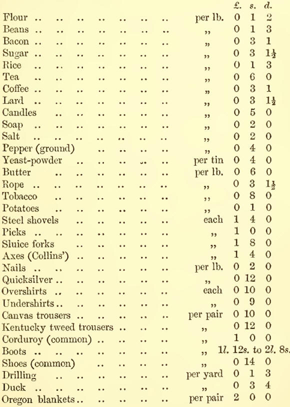
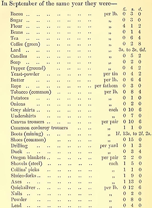
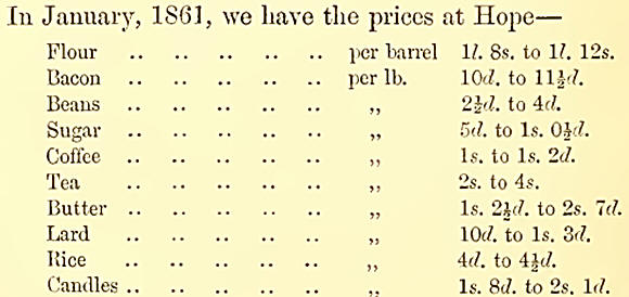
At that time the rates
of freight were very low, in consequence of excessive competition; only
37 per ton being charged from Victoria to Yale, while in the spring of
1860 10/. per ton was charged. Mr. Sanders, the Assistant Gold
Commissioner at Yale, says:—“The miner and labouring man can live
comfortably there on 3s. a day. Charge of restaurants is 21. a week.
Bate of wages 10/. per month and keep.”
He estimates the probable yield of the road-toll between Yale and Lytton
for the year at—
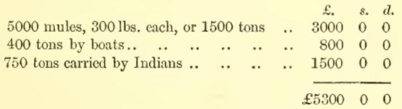
According to the list
kept by him during the past season (1860), 2723 mules were packed to the
interior from that town (Yale). The revenue of the district of Yale for
1860 was—
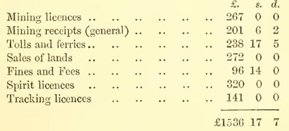
Since that time,
however, some new roads have been completed and several begun, and each
mile of these makes things cheaper. Writing at the same time, the
Governor says: “The works we propose to execute this year are as
follows:—
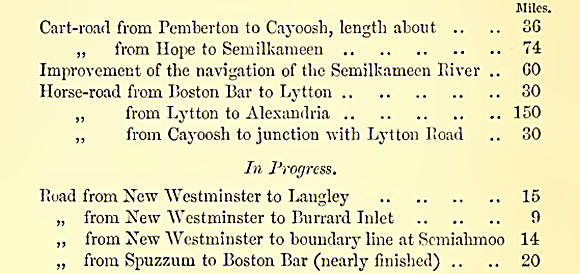
For these purposes he
says the colony can find 25,000/., and asks for a loan of 50,000/.
If the routes which are now being tried between Bute Inlet and Bentinck
Arm to Cariboo succeed, it will make a considerable change in the
commercial position of the towns on the Fraser, and very probably some
difference to Victoria. For Bute Inlet the traffic will still go in by
the strait of Fuca and past Victoria, but if Bentinck Arm becomes a
thoroughfare, vessels bound thither will do much better to keep outside
the Vancouver Island rather than go up the inner channels, for the
entrance to Bentinck Arm is 70 miles north of the north end of the
island. It will be a considerable advantage to these routes if they are
able to avail themselves of inland water-carriage, as it is always so
much cheaper than land-carriage. I have mentioned in proof of this that
on the Lilloett River in the winter of 1858-59, the Indians were taking
goods up the river in their canoes for 5 cents (2Id.) per lb., while the
packers on the trail wrere charging 15 cents (7Ad.).
Mr. Ninel, the magistrate of the Cariboo district, tells me that the
Fraser Fiver between Alexandria and Fort George is navigable for
steamers, and by the latest accounts a steamer is being placed on the
river there. If the Stuart or West Road Rivers are found to be navigable
also, it will shorten the coast routes both in time and expense
immensely, and still more if the Bellhoula Fiver is navigable for any
distance from the coast.
In speaking of the resources of these colonies, the immense supply of
fish of all kinds must not be omitted. The quantity of salmon is almost
beyond description; but it will give some idea of it to say that a
Hudson Bay Company’s officer, who lived many years on the Columbia, told
me that on a sudden falling of the water such numbers were left on the
banks as to cause the river to stink for miles. The usual way of
catching this fish is by spearing from the canoe; in salt-water the
Indians do this as they paddle about the harbours, or, if it be at the
mouth of a river, drive stakes in to keep the fish back, and then spear
them while they are trying to get through. In the rivers a net is fixed
into a frame; the fish run into this and are speared, or, when the water
is still, are taken out with a small scoop-net fastened on the end of a
pole. They use spindles of the Thuja plicata as corks for the upper part
of these nets, and weight the lower part with stones. “The rope of the
net is made of Salix or Thuja, and the cord of Apocymene piscatorium (A.
hyperici-folium ?), a gigantic species peculiar to this country, whose
fibre affords a great quantity of flax.” I have frequently watched this
proceeding. Mr. David Douglas, the botanist, gives such a capital
description of the way these nets are fitted, in his journal, that I
cannot do better than transcribe it literally:—
“The quantity of salmon (Salmo scoulieris—Fichardson) taken in the
Columbia, he says, is almost incredible ; and the Indians resort in
great numbers to the best fishing-spots, often travelling several
hundred miles for this purpose. The salmon are captured in the following
manner:—Before the water rises, small channels are made among the rocks
and stones, dividing the stream into branches, over which is erected a
platform or stage on which a person can stand; these are made to be
raised or let down as the water falls or rises. A scoop-net which is
fastened round a hoop, and held by a pole 12 or 15 feet long, is then
dropped into the channel, which it exactly fits ; and the current of the
water carrying it down, the poor fish swims into it without being aware,
when the individual who watches the net instantly draws it, and flings
the fish on shore. The handle of the net is secured by a rope to the
platform, lest the force of the current should drive it out of the
fisher’s hands. The hoop is made of Acer circuiatum, thg net of the bark
of an Apocymene, which is very durable and tough, and the pole of
pine-wood.” He gives also the size of some fish, and an average weight
rather higher than I should give; but he speaks of the Columbia River,
where, perhaps, the fish are larger. He says they generally weigh 15 to
25 lbs. He measured two: one was 3 ft. 5 in. long, and 10 inches broad
at the thickest part, weighing 35 lbs.; the other 3ft. 4 in., and 9
inches broad, weighing a little less. Both were purchased for 2 inches
of tobacco (about half an ounce) value two-pence.
The mention I have before made of salmon being used as manure at Fort
Rupert will also give an idea of their quantity. Since the influx of
whites into the country, the Indians ask a much higher price for their
fish than they used; but when I first wont there, in 1849, I remember
the largest salmon bought on board weighed 50 lbs., and the price it
fetched was two sticks of tobacco!
The sturgeon also is caught in very large numbers, and of great size in
some parts, the month of the Fraser particularly. Mr. Douglas, the
botanist, mentions one caught by one of my companions, which measured 12
feet 9 inches from the snout to the tip of the tail, and 7 feet round
the thickest part, while its weight exceeded 500 pounds.
Hallibut also reach an immense size, and are caught in great numbers
everywhere; but, as I have said, particularly off the entrance of the
Strait of Fuca.
The herring literally swarm over the harbours in myriads; nothing can
give a better idea of the number of these fish than the way they are
caught. A dozen or so of sharp nails or spikes are driven into a flat
piece of wood 1G or 18 feet long, and 2 or 3 inches broad, making an
instrument like a rake; an Indian sits in the bows of his canoe, and
dipping this down perpendicularly under water sweeps it along towards
the after end of the canoe, pinning some six or eight fish on the nails
each sweep he makes; every time he brings it up, he turns the nails
points downwards, and gives the rake a tap on the gunwale, which knocks
the fish off into the bottom of the canoe. In this way a man will often
half fill his canoe in an hour or so.
There is much more game on Vancouver Island than in British Columbia;
when travelling in the latter, the absence of animal life has always
appeared to me remarkable, while on the former it is generally abundant.
On Vancouver Island, when I went from Alberni to Nanaimo, I shot a
wapiti and two deer, without going out of my way, and might have shot
three or four more wapiti, if we had stopped to do so. This, it must be
remembered, however, was in a part of the island before untrodden by
man; and a settler must not expect to meet deer straying about his
fields, or he will be grievously disappointed. In Columbia, on the other
hand, there are large numbers of mountain-sheep, which are unknown on
the island. This animal is only found on the mountains whose summits are
covered with perpetual snow. I only saw one while I was in the country,
and that was when in the snow crossing from Jervis Inlet to Howe Sound;
instead of wool it has a short thick coarse hair, and from this
circumstance is called by the Company’s servants mouton gris. I have
never tasted it, but Mr. David Douglas says “the flesh is fine, quite
equal to that of the domestic sheep.” He adds, “the horns of the male,
weighing sometimes 18 to 24 lbs., are dingy white, and form a sort of
volute; those of the female bend back, curving outwards toward the
point.” I think Mr. Douglas is wrong as to the colour of the horns. I
have seen many of them among the Indians, by whom they are made into
spoons, and they are far more generally black than clingy white.
The great set-off that Vancouver Island has against the gold of British
Columbia, is her timber; for though timber abounds in British Columbia,
we came upon no place there where such fine spars were to be found, and
with such facilities for shipping as at Barclay Sound and the
neighbourhood of Fort Rupert.
The following is the list of trees found at Barclay Sound, as given by
the woodsmen employed there by the Mill Company already spoken of. I
give first the local names, the scientific being appended, so far as
they are known, by Dr. Bindley:—
Yellow Fir, or Douglas Pine, sometimes misnamed Oregon Pine— Abies
Douglasii.
White Fir—probably Abies alba.
Spruce Fir—probably Abies nigra.
Balsam Fir—Abies balsamea.
Willow Fir—Salix rostrata.
White Pine—Pinus monticola.
Yellow Pine.
Cedar—Possibly Juniperus oceidentalis.
Alder—Probably Alnus viridis.
Dogwood—Cornus alba.
Yew—Taxus baeeata.
Crab-apple—Pyrus rivularis.
Maple (two kinds)—Acer macrophyllnm and probably Acer rubrum.
Hemlock—Abies Canadiensis.
Cotton Wood—Popnlns balsamifera, or Populus monilifera.
Aspen —Populus tremuloides.
Arbutus—Arbutus procera.
Yellow Cypress—Thuja gigantea.
Foremost among them all stands the Douglas fir (Abies Douglasii), named
after its discoverer, David Douglas, the botanist. As timber for spars
or plank, this tree is unequalled. It grows to the height of 200 to 300
feet, and usually as straight as an arrow. This wood has been planted in
several places in England, and should become one of the common trees of
this country. The value of this wood for spars has been tested and
reported on by the engineer of the French dockyard at Cherbourg, whose
report was greatly in its favour. As plank, it is equally fine. Dr.
Lindley tells me he has had two planks, about 20 feet long each, which
have been in his house in a room where there is constantly a fire, since
1827, and that neither of them has warped or shrunk the least since they
were first placed there.
The following extract relating to the Douglas fir is from the
'Gardeners’ Chronicle’:—“We now know that this most beautiful tree, the
Douglas fir, is unsurpassable in the qualities which render timber most
valuable. It is clean-grained, strong, elastic, light, and acquires
large dimensions in ungenial climates. It thrives everywhere in the
United Kingdom, except the extreme north, and is therefore of all trees
that which most deserves the attention of planters for profit. To which
we may add that no evergreen surpasses it as an ornament of scenery.
“Little or nothing was known of the Douglas fir until it was brought
into notice by the Horticultural Society, which received its seeds from
the hardy collector whose name it bears, and distributed some thousands
of young plants among its Fellows. As this happened about
five-and-thirty years ago, there must already be an abundance of good
specimens in the country. The purpose of this notice is to increase them
to the utmost, by inducing landed proprietors to substitute the Douglas
fir for the very inferior spruce.
“The Douglas fir makes its first appearance on the mountains of Northern
Mexico, in the country near the Beal del Monte mines. Thence it follows
northwards the western slope of the Rocky Mountains, at least as high as
the now celebrated but savage Cariboeuf, or Cariboo gold-field, in
British Columbia. Douglas, the collector, who crossed the Rocky
Mountains a little to the south, through the 'Committee’s Punchbowl
Pass,’ reported that it formed vast forests there on the lower ranges,
and struggled upwards till it became mere scrub. We ourselves had, till
lately, bark of the tree from those desolate regions fully six inches
thick.
A spar of this fir, more than 200 feet high, has been erected in the
Eoyal Botanic Gardens at Kew; and sections, cut at intervals of 15 feet,
of a tree 309 feet long, were sent to this country for the International
Exhibition. A horizontal section of another tree having been sent for
the same purpose, a careful examination of it was made to ascertain its
age and rate of growth. The result of this examination, which has
appeared in the ‘Gardeners’ Chronicle,’ will be found interesting.
"The diameter is (5 feet, viz., 34 inches on one side, 38 on the other.
Its rate of growth on the 34-inch side has been
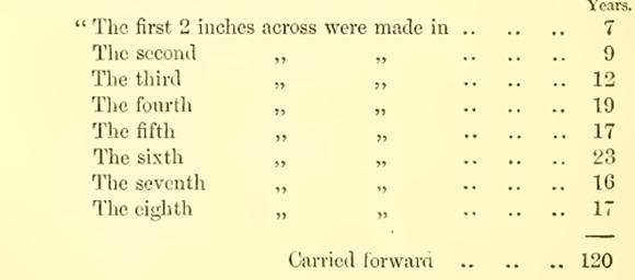
“It is as well to
remark that tin's British Columbian fir, although three centuries and
a-half old, and although for the last forty-two years it increased
little more than l-10th of an inch in diameter yearly, is perfectly
sound to the heart. Foresters will understand the importance of this
fact.”
Mr. Sproat, the Barclay Sound Mill Company’s agent at Victoria, says of
this wood:—“The bark of the tree is very like that of the Canadian
hemlock. At its base, and for some distance up, the bark is often a foot
thick; the sap is always thinner in proportion as the bark is thick, and
vice versa. The sappiest trees are those that grow in the sunshine. The
wood varies in colour; a yellowish colour predominates, though a good
many are reddish. The colour appears to depend much on the age and
situation of the tree, on its greater or less exposure to the sun.”
The cone of this tree can never be mistaken, as on the outside of each
scale is a sort of claw, with three fingers to it, distinguishing it
plainly from all other fir-cones.
The white fir (Abies alba) is poor, compared with the Douglas, though
the trees are often a considerable size.
The white pine (Pinus monticola) makes very good plank for building
purposes.
The yellow cypress (Thuja gigantea), which abounds more in the north
than the south of the colony, is a very useful wood, light, tough, and
elastic; it makes the best plank for boat-building that I have ever
seen. Its leaf differs from that of the other and common cypress (Thuja
occidentalis), in being convex on both sides.
For ornamental purposes the bird’s-eye maple (Acer macro-phyllum),
dogwood (Cornus alba), cedar (Juniperus occidentalis), and arbutus (Arb.
procera), are all valuable.
The maple and cedar are very plentiful, and the latter grows to a great
size.
The fertility of the soil wherever it has been tested is, as I have
before said, great; and the quantity of wild fruits and flowers which
abound everywhere is very remarkable. In all swampy places cranberries
of two or three sorts grow so plentifully that a flourishing trade is
driven with them at San Francisco. Wild strawberries and raspberries,
sallal, barberries, black and blue berries, salmon-berries, currants,
and gooseberries abound. In the summer, when we were away surveying, the
Indians brought such quantities of these alongside that the whole ship’s
company were usually surfeited before the season was over.
There are also several kinds of bulbous roots, the commonest is the
camass (Scilla esculenta), of which the Indians eat a great deal; it has
a slight onion flavour, but is sweet.
I need not attempt a detailed account of the plants and shrubs of the
colonies. Mr. David Douglas has described many; and a fuller account may
be expected from Dr. D. Lyall, who has been attached to the Boundary
party, and with them examined the country from the coast to the summit
of the Rocky Mountains.
I may mention, however, that hops grow remarkably well, and that a
species of tobacco and tea are to be found in Columbia. The former of
these was first collected by Mr. Douglas, who says, “Among the most
interesting of the plants which I gathered last year (1825) is a species
of tobacco, the Nicotiana pulverulenta of Reush, correctly surmised by
Nuttall to grow on this side of the Rocky Mountains; though whether this
country, or the Eocky Mountains themselves, or the banks of the
Missouri, be its original habitat, I am quite unable to say. I am
inclined to think, however, that it is indigenous to the mountains,
where the hunters say that it grows plentifully. The Nicotiana is never
sown by the Indians near the villages, lest it should be pulled and used
before it comes to perfect maturity. They select for its cultivation an
open place in the wood, where they burn a dead tree or stump, and,
strewing the ashes over the ground, plant the tobacco there. They say
the wood-ashes invariably make it grow large.” I have smoked this at
Fort Kamloops, and liked the flavour—which was similar to that of mild
tobacco—very much.
The wild tea-leaf resembles that of China tea. I have never tasted it,
but Mr. Pemberton says, “ its flavour is not bad and effect
exhilarating.” He adds, “Some years ago the Hudson Bay Company imported
a cargo, but it was stopped at the Custom-house and thrown overboard to
avoid the duty.”t
I have been favoured by my friend Hr. Wood, of H.M.S. ‘Hecate,’ with the
following remarks upon the natural history of the two colonies. I have
much gratification in being able, by Dr. Wood’s friendly compliance with
my request, to lay before the reader information so trustworthy and
valuable.
“In the following remarks I do not assume to give more than a cursory
sketch of those sections of the natural history of British Columbia and
Vancouver Island which are of most interest to the general reader.
Separated by a few miles of ocean, the Fauna and Flora of both colonies
are the same—insular position and a less extensive area, however,
causing one to bo sparse in many things which her larger neighbour
possesses in profusion, while again the ocean-washed shores of the
western side of Vancouver Island are rich in resources which British
Columbia possesses less abundantly. As I am personally better acquainted
with Vancouver Island, and as less is known of it than of British
Columbia, I will in a great measure confine my remarks to the former,
asking the reader to remember, however, that, unless the contrary is
indicated when speaking of either colony, I include both.
“I pass over the First and Second Orders of Mammals (the first embracing
the peculiar province of the Ethnologist; the second, or monkey-like
animals, not being represented in these colonies), and commence with the
Carnivora, the first and second families of which are also sparingly
represented. Among them are
“Bears.—The Black Bear, Ursus Americanus, is often seen, and falls
easily to the gun of the sportsman. Unless when wounded, it never
attacks man. This hear is chiefly a vegetable feeder. The flesh is
coarse, but good; and the skin, which is of little marketable value,
makes a good rug.
“The Grizzly, Ursus horribilis, is not found on the Island: it is
sometimes shot in British Columbia, but its chief home is the Rocky
Mountains. It is wisest to leave him unmolested.
“The Racoon, Ursus lotor, is a harmless animal, easily tamed. It feeds
mostly on wild fruits and, it is said, small birds. It is very numerous
in some parts of the coast.
“Martens.—The yellow-breasted or Pine Marten, Mustela martes, and one of
a whole colour, are very numerous. Their skins are in great request, and
are collected in large numbers by the fur-traders. A good one is worth
from 6s. to 8s. The Common Mink, Putorius vison, is also found in great
numbers. The Skunk is also frequently seen.
“Otters.—The Land Otter, Mustela lutra, is frequently shot by the
Indians. The skin is of little value. The Sea Otter, Enhydra marina, is
found throughout the north-west coast of Vancouver. The skin is much
sought after, being an extremely valuable fur. The skin, of a full-sized
one, undressed, and measuring 6 feet, commands the price of thirty
blankets—121. to 14Z. They are sent to England, and, when dressed,
forwarded to China, where the finest sometimes fetch 100 dols.
(American) apiece.
“Wolves.— Two species of wolf are known to the settlers, and are
commonly spoken of as the Bed and Black Wolf. They do not much frequent
the settled districts except in winter, when they are very destructive
to sheep unless watched. They are cowardly, and I have not heard of
their ever attacking men.
“Foxes.—There are two varieties of this animal, the ‘Red’ and ‘Silver
Fox.’ The latter is found in British Columbia, not upon the Island.
“The American Panther or Puma, Felis concolor, is often shot upon
Vancouver Island. They are destructive to sheep, and more particularly
to pigs and poultry. When followed, they often take refuge in a tree,
from whence they are easily shot by a common fowling-piece. Dogs will
also attack them. They are quite harmless to men.
“Seals.—One variety of Seal frequents the mouth of the Fraser River,
British Columbia, where it may constantly be seen by visitors in summer,
seated on a log of wood drifting downwards with the current. Another is
found on the sea-coasts of Vancouver Island, and is shot in some numbers
by the Indians, who sell their skins to the fur-traders.
“The Squirrel, Sciurus ( Cuv.), is very numerous throughout the pine
forests, feeding on the cones of the various fir or pine trees. They are
shot in great numbers for the table, and are excellent eating. There are
two or three varieties, smaller and otherwise characteristically
different from the English species. Ground squirrels are also found.
“The Marmot, Arctomys moncicc, is kept by the settlers sometimes as a
domestic pet. It is said that rats never stay in a house in which a
marmot is a resident.
“The European Rat is very common on the Island in settled districts, as
much a pest as it is at home. Both rats and mice indigenous to the
Island and British Columbia exist, but they do not require separate
mention.
“The Beaver, Castor Canacliensis, is found on the Island, and also in
British Columbia. Very few are now trapped for the sake of their skins.
They are sometimes shot by Europeans for the sake of their flesh, which
is palatable. The tail, which is extremely fat, is considered a
delicacy, and somewhat resembles the fat of the turtle. A few years ago
780 beaver-skins were traded in a twelvemonth at one establishment of
the Hudson Bay Company on Vancouver Island. The Beaver, as also other
fur-bearing animals, is said to be increasing in numbers since the
partial settlement of the western shores of North America, from the fact
of its being less molested, owing to the employment of the 'trapper’ in
other pursuits.
“I have not seen a specimen of either a Hare or Rabbit obtained from
Vancouver Island. Several varieties of both exist on the neighbouring
continent and throughout British Columbia. They differ much, however,
from the English varieties, both in habits and appearance.
“The Canadian Stag or Wapiti, and the Elk, Cervus Canadiensis, exist in
numbers; they sometimes equal the horse in stature, and I have known
them shot, weighing, when dressed, 600 lbs. The horns are very handsome.
The Black-tailed Deer—the Fallow Deer of the Pacific, Cervus Columbianus
— are found throughout both colonies, and are very numerous on the small
islets, to which they swim, I believe, to escape the wolves. They
become, in certain localities, very fat towards autumn, but, though
excellent, want the flavour of English venison; from 60 to 80 lbs. is an
ordinary weight. The district of Cariboo in British Columbia, now so
noticeable for its produce of gold, is so called from a large deer which
frequents its pasturage—probably the Rangifer caribou of Audubon. The
‘Mountain Goat’ and the ‘Mountain Sheep’ are found in the mountains of
British Columbia. I am not aware of their existence on Vancouver Island.
“The American Buffalo, Bos Americanus—has lately found its way, it is
said, through the Rocky Mountains to the upper plains of the Columbia.
“Cetacea.—With this order of mammals I am little acquainted. Whales,
‘Black-fish,’ and Porpoises are common off the coast of Vancouver and
the inland sea separating it from British Columbia. Considerable
ingenuity is shown by ’ the Indians in the capture of the whale. A
seal-skin, prepared so as to be air-tight, is attached to a harpoon, the
head of which, with a short rope made from cedar-bark, can be detached
from the staff. With this attached to him, the whale is not long before
he makes his appearance above water, when he is killed by spears, great
numbers taking part in his destruction. The flesh is much esteemed by
the natives as food.
“Birds of Prey, Raptores.—A frequent object met with on the coast-shores
of both colonies is the White-headed Erne or Great Fish Eagle, Falco
leucocephalus. Couples of these birds are frequently seen sailing
majestically in air, descending occasionally in graceful circles to
their abode in some tall pine-tree where their nest is placed. Another
common object is the American Osprey or Fish Hawk, Pandion Carolinensis.
The Harrier and the Sharp-shinned Hawk, with several others, are also
constantly met with. The 'Great Snow Owl,’ Nyctea nivea, and the Pigmy
Owl, Glaucydium gnoma—not so large as an English blackbird—are also
found, with several others.
“Scaxsores.—In this order occur the Cuckoos. I have not seen a specimen
on the island or in British Columbia, but their note has been heard by
myself and others. The Woodpeckers are numerous: thus, I may name Picus
Harrisii; Sphyrapicus ruber, or Bed-breasted Woodpecker; Colaptis
Mexicanus, or Bed-shafted.
“Ixsessorks.—I have collected three varieties of Humming birds on
Vancouver Island. These beautiful little creatures make their appearance
early in spring, even before the snow has left the plains, buzzing their
way from bush to bush in restless search of some half-opened blossom.
The Indian boys snare them in numbers, and, fastening a dozen or more to
a stick by one foot, bring them off alive to the ships for sale. A Night
Hawk—known among settlers as the Mosquito Hawk—breeds upon the island,
and makes its appearance on summer evenings. A common object along the
sea-coast and the mouths of rivers is the Belted Kingfisher, Ceryle
alcyon—a much larger, but not so handsome a bird as the English
Kingfisher. The Flycatchers have several representatives. The Singing
Birds are few. Amongst the Swallows may be named the Violet-green
Swallow, lliraudo thalassina. Wrens, Creepers, Nut-hatches, Titmice,
Shore Larks, Finches, the Bed Crossbill, Curvirostra Americana, the Snow
Bunting, Sparrows, the Bed-winged Blackbird. Among the crows may be
named the American Raven, the Fish Crow, the Common Crow. Jays, Cyanura
stelleri.
“Basores.—Pigeons and Doves are represented in both colonies. A more
numerous family exist in the Grouse: the Dusky Grouse, Petras obscurus;
the Blue Grouse of settlers; the Ruffed Grouse, Bonasa umbus; and the
Willow Grouse, Lagopus albus, are found on Vancouver Island in immense
numbers, and also in British Columbia, which has several other
varieties,—the Sage Cock, the Sharp-tailed Grouse, the Prairie Hen, and
Ptarmigan : all of these are excellent eating, but are too easily shot
to afford much amusement to an English sportsman. The Blue and the
Buffed Grouse roost on trees during the day, when not sunning themselves
on some hillock or prostrate trunk of a tree, where their ‘drum’ is
loudly heard. The Blue Grouse reaches the weight of lbs.; it may often
be seen perched on the topmost branch of some tall pine-tree, from
whence he refuses to move for repeated charges from an ordinary
fowling-piece, and is only to he brought down by a rifle. As the country
becomes cleared, their habits will probably change, and Vancouver Island
will be as noticeable for good sport as Scotland.
“Grallatores.—The Great Blue Heron or Crane, Ardea herodias, is
frequently seen and shot. In the sub-order Grallcc may be enumerated
Golden Plover; Kill-deer; King Plover; the Surf Bird, Aphrizci vinjata;
Bachman’s Oyster-catcher,, Hcematojms nifjer, and Turnstone; "Wilson’s
Snipe, or English Snipe; Grey Snipe; Jack Snipe; Sandpipers; and
Sanderlings.
“Natatores.—Swans are often shot on the lakes of Vancouver Island and
British Columbia; and on the approach of winter myriads of Geese arrive:
among these may be named the Snow Goose, Anser hyperboreus; the
White-fronted Goose, Anser gambelii; the Canada Goose, Bernida
Canadiensis; the Brant Goose. The Canada Goose is often shot 17 lbs. in
weight. The Ducks are innumerable. Amongst them are found the Mallard,
Anas boschas; Black Duck, Anas obscura; Pintail, Dajila acuta;
Green-winged Teal, Nettion Carolinensis; the Shoveller, or Spoonbill,
Spatula dypeata; American "Widgeon, Mareca Americana; the Summer Duek,
Aix sponsa; the Scaup Duck, Fulix marila; Canvas-back, Ay thy a
vallisneria; the Golden Eye, Bucepliala Americana, and albeota or
Buffle-kead ; the Harlequin Duek, Histrioniaus torquatus Amongst the Sea
Dueks are the Velvet Duek, Melanetta velvetina; the Surf Duck,
Belionetta perspicillata; the Scoter, Oidemia Americana. Among the
Eishing Ducks is the Goosander, Mergus Americanus; the Red-breasted
Merganser, Mergus serrator; the Hooded Merganser, Lophoclytes cucullatus;
and I believe a fourth which is not named. In the sub-order Gavice, I
may mention the Sooty Albatross, Diomedia fuliginosa; and two or three
Petrels. Among the Gulls, the Glaueous-winged Gull, Larus glaucescens;
the Herring Gull, Larus argentatus; the VTestem Gull, Larus occidentalis.
Among the Cormorants, the Violet-green Cormorant, Graculus violaceus, is
extremely common. In the family of Divers are the great Northern Diver,
Colymbus glacialis; the Black-throated, Colymbus arcticus; the Pacific,
Colymbus Pacificus; and the Red-throated, Colymbus septentrionalis. The
tufted Puffin, Mormon cirrhata ; the Horn-billed Guillemot, Cerorhina
monocerata, are numerous on the sea-eoasts of Vancouver and its adjacent
islands, and the sea around them is often literally alive with the Sea
Dove or Dovekie.
“The Reftilia do not require an extended notice. Several varieties of
Snakes are met with, but they are not, I believe, venomous. Lizards and
Frogs are numerous. The Bull-frog in summer is rather a nuisance by his
loud croakings. The Indians are partial to snakes as an article of diet;
immediately they are caught they are skinned and eaten by them, as a
stick of celery is eaten by a schoolboy, and with as little cooking.
“Fishes.—The fish of Vancouver Island and British Columbia require a
more extended experience than mine to do justice to them. I cannot,
however, but think that, among the domestic resources of both colonies,
few can equal their value. The seas and large inlets, the bays and
rivers, are literally alive with fish. Salmon, Cod, Halibut, Sturgeon,
Herring, Trout, Smelt, Sea Perch, Hake, Sardines, Anchovy, Flat Fish,
Hog Fish (highly useful for oil), and the Houlakan, so called by the
Indians ; the latter, the size of a herring, makes its appearance with
unerring regularity in various parts of the coast for a few days only,
and is taken in shoals; it is so fat on its arrival as to defy ordinary
cooking, melting by the heat; it is pressed for oil by the natives, who
trade with it in British Columbia with the inland tribes, and is also
dried, in which state, lighted at one end, it makes a capital torch, and
is constantly used as such by the Indians. The oil has been used
medicinally in place of cod-liver oil, and I have seen the happiest
effects from its administration. So numerous are the Salmon, that rivers
become offensive from the putrid bodies of those who have failed to make
their way up the ‘falls’ of the various rivers. Tons’ weight of Halibut
may be caught in a day. The shores are thickly covered with
Acorn-shells, Limpets, Muscles, Clams, &c. Crabs of many varieties are
found everywhere, some edible, and of large size. The Shrimp is a
constant visitor in the dredge, and Prawns are extensively caught in the
neighbourhood of Victoria, Vancouver Island. Every pool is lined with
brilliant Sea Anemones; and nearly throughout the year is the sea
lightened with Medusae.
“Flora.—In the magnificent work of Sir W. J. Hooker, ‘Flora Boreali
Americana,’ may be found an epitome of the botany of these colonies. I
will confine my observations, therefore, to an enumeration of the
Natural Orders, which contain most of the Flora of interest to the
settler.
“Order 1. Nymphceacece, Water-lilies.
“ ,, 2. Ranunculacece, Crowfoots.
“ ,, 5. Cruci/erce, Cressworts.
“ Order 7. Berberidacecc, Berberry worts. Tlie ‘ Oregon Grape ’ of tbe
settlers is a small shrub very common in the woods ; it bears a yellow
flower, and produces a cluster of berries of a deep blue colour, of a
pleasant acid, astringent taste. The root 3Tields one of the best known
yellow dyes.
“ Order 8. Violacece, Violetworts.
“ ,, 16. Ceracece, Maples. The Maple grows to a large size, and is
extensively found ; it produces by the changing hues of its foliage a
handsome object in the somewhat monotonous landscape of the colonies :
its wood is very inferior.
“ Order 17. Geraniacece, Cranesbills.
“ ,, 21. Rhamnacece, Rliamnads.
“ ,, 22. Fcibacece, Leguminous Plants. Representatives of their order
are extensively found. The Blue Lupine, Purple Clover, and several
varieties of Yetch are everywhere growing wild as large and strong as
any I have seen cultivated in other places.
“Order 23. Rosacea, Roseworts. Species of this order are also very
numerous: in the spring every plain is covered with the Wild Rose and
Sweet Brier: in the sub-order are Wild Apples, the Mountain Ash
(scarce), the Service Tree, Bird Cherry or Cluster Cherry.
“Order 28. Grossulariacece, CurrantworR. Wherever the ground is clear
abound Currant and Gooseberry bushes of endless varieties ; the
Flowering Currant, Ribes sanguinea, is a beautiful object in the ‘bush.’
“Order 30. Apiacecc, Umbellifers, the Conium.
“,, 32. Cornaccce, Cornels. The Dogwood tree is very common, and makes a
handsome object for the shrubbery. In this order is the ‘La Broue’ plant
of the Canadian voyageurs : it bears a small red berry which is dried
and stored for use. Mixed in small portions with a little water it is
after standing ivhished up with branches; it gradually expands and
becomes converted into a substance resembling ‘ trifle,’ which is eaten
with sugar sifted over it.
“ Order 33. Caprtfoliacecc, Caprifoils. Two varieties of Elder tree very
common.
“Order 38. Campanulacece, Bellworts. The Campanula.
“,, 39. Ericacece, Heath worts. In a Sub-order are the Cranberries.
These shrubs abound everywhere, and yield a most delicious berry ; there
are many varieties—from one, the Oxycoccus palustris, 1 have known of
100 barrels being collected, the produce of one season. Tlie berries do
not require putting down, keeping remarkably well simply immersed in
water. The Gualtheria shallon, the ‘Salal’ of the Indians, is a common
shrub : it bears a handsome blossom and a bunch of large deep purple
berries, much used by the natives, who make it into cakes which they dry
in the sun for winter use; it is also used in the households of settlers
for pies and puddings, but is not equal to the Cranberries.
“Order 41. Gentianacece, Gentianworts.
“,, 56. Urticacece, Nettle worts. A wild Nettle, the Urtiea cannabina,
is used by the Indians to make hemp; it is extremely strong, and is
manufactured by them into twine, rope, and nets.
“Order 57. Corylacece, Mast worts. The Oak is abundant in the southern
part of Vancouver Island; there is none in British Columbia, I am told
by Mr. Anderson, of the Hudson Bay Company, except a few small specimens
on the eastern borders of the Rapids above Fort Yale. The Hazel Nut is
common in British Columbia. .
“Order 58. Saliacece, Willowworts. Willows grow on all low and swampy
places; the ‘Cotton Wood’ Poplar and the Aspen tree. •>
“Order 59. Betulacece, Birchworts. The common Birch is of small size to
the southward; in the northern parts of British Columbia it is known as
the ‘Canoe Birch,’ is abundant and of large size, and is hard and
durable (Mr. Anderson). The common Alder grows to a large size, and is a
useful wood for turners.
“Order 61. Pinacece, Conifers. In this Order are found Yew trees,
Juniper bush, the Scotch Fir, Spruce Fir, the Douglas Pine; the White
Pine of commerce, Finns Weymouthii; Canada Pino, Balsam Pine, the ‘Red
Cedar,’ and the ‘Yellow Cedar.’ The most remarkable point in the
forest-trees of both colonies is the profusion of trees of this order,
and the immense height and size they attain. The Douglas Pine can be
obtained anywhere 200 ft. in length, and I have seen trees that would
square 45 in. for 90 ft. This pine makes the best spars for ships. The
‘White Pine,’ I am told by those preparing it, is equal to that of the
Eastern States of America. From the bark of the ‘Red’ and Yellow Cedar,
articles of wearing apparel, ropes, &c., are made: the plank of the
latter tree yields a close-grained beautiful wood; specimens of it made
into boxes have been sent to the International Exhibition.
“Order 68. Liliacece, Lilyworts. The Gamassia esculenta, the Camass of
the Indians, is very common: the bulbs, being placed in shallow pits,
are covered with a thick layer of dried grass damped with water, a thin
layer of earth is placed above it, and a fire made over the pit. A
gradual process of steaming goes on, perhaps for several days: the bulbs
when removed are found mellowed, their colour changed to a light brown,
and they contain a large portion of saccharine matter. They are then
dried and stored for winter food.
“Order 73. Graminacece, Grasses. Varieties of nearly every grass which
grows in England, and many which do not, are found in these Colonies:
the Wild Oat is as vigorous a plant here as the one cultivated at home.
I have seen ‘Timothy Grass’ grown on the Island 8 ft. in height.
“I pass over the Ferns, Mosses, Lichens, the Fungi, and Seaweeds, with
the brief remark that they abound everywhere, the first in quantities
somewhat troublesome to the agriculturist.
“Charles Bigland Wood.
“H.M.S. ‘Hecate,’ Victoria, Vancouver Island,
“July, 1862.”
It would be useless for general purposes to give a mass of statistics
with regard to the climate of British Columbia and Vancouver Island. In
a country embracing so many hundred miles of latitude there is of course
great difference of temperature. The climate of Vancouver Island may be
said generally to be about the same as that of the south of England.
During the last winter, 1861-2, it has been unusually severe. In the
four winters that I passed at Esquimalt Harbour we had a great deal of
rain, very little snow, while the ice on the ponds bore skaters for
about a fortnight each year, the thermometer being hardly ever below 25°
Fahr. The south part of British Columbia is, perhaps, a little colder.
This winter the Lower Eraser has been frozen over so as entirely to
impede navigation; but I believe this has never been known before, and
it certainly has only occurred once since 1856. Steamers were able to go
to Langley every winter I was in the country, and were only prevented
ascending to Fort Hope by the shallowness of the stream. It will also be
remembered that I ascended the river to Fort Yale in February, 1859,
without being seriously impeded by ice.
The fall of snow even during the late extraordinarily severe winter
appears to have been very partial. The thermometer at Westminster stood
at 8°, 10°, and 12° below zero, and 17° or 18° at Forts Hope and Yale.
The deep snow at these latter places, however, made them less cold than
at Lilloett, where there was only an inch or two of snow, and where the
cold is described as having been intensely severe.
Further north, at Cariboo, the winter of 1860-1 was even more severely
felt. On the night of the 1st of December the mercury of the thermometer
congealed, and on the 25th and 26th of January it is said to have
stiffened before sundown, with the sun shining full upon it. Two
thermometers at William Lake are reported in the Victoria papers to have
burst from the effects of the cold, and many instances of severe
frost-bites, &c., are given. In judging of the severity of the season
from the reports of the miners, however, it must be remembered that
their clothing and habitations would ill fit them to endure with
patience the hardships of an ordinary winter even in England.
In a recent book on British Columbia one of the many objections urged
against the country is said to arise from the danger of Indian
aggression upon the colonists. I cannot conclude these remarks without
giving this assertion an emphatic contradiction. My own experience—as
the reader will have gathered—has led me to form an exactly opposite
opinion of the temper and disposition of the Indians; and lest it should
be thought that my official position gave me when travelling alone among
them a protection which would be wanting to the ordinary colonist, I
give the following quotation upon the subject from the letter of a young
English clergyman whom I have lately had the pleasure of meeting. I
withhold his name only because his letter was not intended for that
public use which I venture to make of it. I should add that the writer
had never visited an English colony until he went to British Columbia
four years ago:—
“My experience leads me to say, what I find most persons confirm, that,
so far as safety is concerned, there is far less risk in travelling in
British Columbia than in many parts of England. Nothing can exceed the
order of the country, and the marked absence of serious crime either on
the part of the whites or Indians.”
This was written after a journey of more than 500 miles in the interior,
alone or with some fellow-clergymen. Those who desire further evidence
of the kindly disposition of the Indians will find it abundantly in the
extracts of the Bishop’s Journal, published by the Columbian Missionary
Society.
I have more than once spoken of Esquimalt as being admirably adapted for
a naval station and dockyard. I wish to add that, important as this is
for our squadron in the Pacific, I think it would be still more so for
the squadron in the Chinese waters. Our ships there, which are sometimes
almost disabled by sickness, could reach the healthy climate of
Vancouver in six weeks, and might, if required, be relieved by vessels
from the Pacific squadron. In 1859 the ‘Tribune’ and ‘Pylades’ were
ordered across from China; they arrived at Esquimalt with crews greatly
debilitated, and all hands a good deal below par. They remained about a
year there, and left, I believe, with the crews of both ships in perfect
health. I may also mention that the healthy appearance of our crew was
a'subject of general remark to all ships arriving on the station.
The climate is said to be unfavourable for people who have previously
been subject to rheumatism. The officers and men of the ‘Plumper,’
however, who lived constantly in camp, and were much exposed, never
suffered seriously from this complaint.
In concluding this rough summary of the resources of the colonies, let
me repeat, that in our North American possessions we have, independently
of its mineral wealth, a country of immense extent and natural beauty,
of—so far as it has been tested—invariable fertility, and with a climate
closely resembling our own. Against these advantages, however, it must
be remembered that all that is required to develop and utilise the many
natural advantages of the colonies has yet to be done, and that for many
years to come stout hearts and strong hands will find abundant
occupation in accomplishing this work. He who is not possessed of these
requisites of a bush-life is as unfit for British Columbia as for any
other colony. But the man whose-heart does not fail him at the prospect
of hard living and harder work, will find there welcome and plenty
awaiting him. |


