|
On the 5th of April we
left Esquimalt to commence the summer work, and proceeded to Nanaimo to
fill up with coal. On our way we stopped at the northern settlement on
Admiral Island, as it had been reported that some Indians had been
troublesome there. We foimd, however, that the Indians had done nothing
more than tell the settlers occasionally, as Inchans do everywhere, that
they (the whites) had no business there except as their guests, and that
all the land belonged to them. At the Ganges Harbour settlement some of
the black settlers had been robbed by them. The Indians always
stedfastly refused to regard black men as entitled to any of the respect
claimed by and shown to the whites. They also entertain the same feeling
with regard to the Chinese. I remember an Indian once asking me about
them, and saying, “Wake, wake!” (“No, no!”), most decidedly, when I told
him they were “carqua King George men” (“the same as Englishmen”).
It appeared to be most desirable here, as at other places, that the
Indians should be duly paid for their land. This is not so simple as it
may seem, however, even supposing the money necessary for such a purpose
to be forthcoming. In New Zealand the Government spent many thousand
pounds purchasing the land, appointing agents, commissioners, &c., and
something of the same is no doubt as necessary here. Vancouver Island,
however, has no revenue available or sufficient for such a purpose, and
of course the revenue of British Columbia cannot, while the two colonies
are distinct, be applied to it. Another difficulty would be found in the
con-dieting claims of the various tribes, arising from their habits of
polygamy and inheritance from the female side, together with the absence
of any documentary or satisfactory evidence of title.
If, therefore, any one chief or tribe were paid for a piece of land
without the acknowledgment on the part of adjacent tribes of the
vendor’s right to the land sold, five or six other claimants would in
all probability come forward asserting the land to be theirs, and
founding their title to it upon some intermarriage of its former
possessors. The difficulties arising from the Indian custom of descent
from the female side are most perplexing. Mr. Weynton, of the Hudson Bay
Company, who resided some years at Fort Rupert, told me he had known, on
the death of a chief, a man from quite another tribe step in and take
the chieftainship, without, so far as he could ascertain, any close
connection with the tribe he claimed to rule. Admiral Island, for
instance, of which I am now speaking, would, in all probability, be
claimed by no less than four tribes, viz., the Cowitchin, the
Penalikutson, a small tribe living among these islands, the Nanaimos,
and Saanitch Indians. On the occasion of our present visit, the
settlers, in reference to this subject, said the Indians had never been
there before, and that they had established a village there for the sole
purpose of asserting their claim to compensation for the land. Upon our
telling one of them this, he pointed to a small stump by which we were
standing, and said it marked his father’s grave, where he had buried him
three years ago—long before any white settler came to the place.
From Nanaimo we went to the Qualicome River, from which a trail leads
across the island to the head of the Alberni Canal, which runs up from
Barclay Sound on the west coast. Between Nanaimo and Qualicome, and
twenty miles from the former, is the magnificent harbour of Nanoose. The
Nanoose district, as the neighbourhood of this harbour is called,
contains a considerable quantity of very good land. In the course of a
journey I made in the following year from the Alberni settlement to
Nanaimo, I passed over this district, and found a large quantity of land
well adapted for settlement. Some parts of it are rather light and
stony, and there are a few swamps; but the greater portion is rich black
vegetable mould, lightly timbered, and well watered by the Nanoose
River, which runs into the harbour, and by several smaller streams. From
Qualicome to Alberni the distance in a straight line is only twelve
miles, this being the narrowest part of the island, except at the very
northern end, where Quatsinough Inlet runs in from the west side to
within seven miles of Reaver harbour on the east, in which Fort Rupert
is situated.
In the year 1859 Captain Richards crossed the island from Qualicome to
Alberni, before the settlement at the latter place was established, in
company with one of the Hudson Bay Company’s agents, who goes there
every year to purchase sea-otter skins, &c., from the natives of the
west side. He found that, after ascending the Qualicome River for some
fom- or five miles and crossing a ridge 600 or 800 feet high, they came
to a lake six miles long, called Horne Lake. This they crossed in a
canoe which the Indians kept there on purpose for Mr. Horne, the Hudson
Bay Company’s agent, to make his annual trip in, and then, ascending the
ridge at its western end, they looked down on the Alberni Canal five
miles off. The ridge to the summit of which they ascended has since been
named “Steep Ridge.” It lies across the head of the Alberni, and the
ascent from Horne Lake to its summit was so steep that Captain Richards
was convinced that, however well it might answer as a trail for foot-travellers,
it could never be used as a roadway. In the summer following that of
which I am now writing, and two years after Captain Richards had
examined this route, we happened to be engaged in surveying Barclay
Sound and the Alberni Canal. The Governor having expressed a great
desire to find a way of connecting the settlement then becoming
established at Alberni with Nanaimo, by crossing the mainland instead of
sailing round the island, I was instructed by Captain Richards to
ascertain whether a way existed across the island to Nanaimo by a valley
that seemed to be more favourable for the purpose than that which he had
previously traversed from Horne Lake. Although, as I have said, this
journey did not take place till a year after the period of which I am
now writing, it will perhaps be desirable to describe it here, since it
relates to the part of the island now under consideration.
On the 29th April, 1861, therefore, having made all necessary
arrangements, we left the settlement at Alberni to make our way to
Nanaimo, a distance as the crow flies of about 40 miles. Our party
consisted of six Somass Indians, Mr. Bamfield, the Indian agent at
Barclay Sound, and one Royal Marine from H.M.S. ‘Hecate.” I have before
spoken of the difficulty of effecting a start with Indians, and on this
occasion more than ordinary trouble was experienced. It was still early
spring, so that while the Indian’s winter stock of provisions was
exhausted, the berries upon which he relied for subsistence were not yet
in season; and they were living from hand to mouth on what they could
shoot and their daily haul of fish. The consequence of this was, that
before I could induce any of the Indians to accompany us, I had to make
arrangements for the provisioning of their wives during their absence,
and to give an undertaking that Captain Stamp, the gentleman in charge
of the saw-mills, would see to their being provided with food if our
journey to Nanaimo and back should chance to exceed the estimated time.
I refused on this occasion to recognise more than one wife to each of
the Indian guides, although I was aware that some had more; but even
this arrangement—which is, however, absolutely necessary— adds much to
the expense and trouble of such journeys.
After everything has been settled, farewells said, and the packs
distributed and arranged—always a matter of much consideration—the mere
process of getting under weigh will often occupy two or three hours.
First, one fellow will make the discovery that he is not provided with
“scaarlux” (breeches), and that he will be torn by the bushes. His want
met, another will plead the need of mocassins, and although it is pretty
certain he will make no use of them, a pair of shoes has to be found for
him somehow. Powder and shot will next be applied for, and matches must
be served out all round. When at last stirred by the strongest
expressions of which the Chinook vocabulary is capable, some sort of a
start is made, the leader will find that his mocassins are imperfectly
laced, or his pack not perfectly balanced, or, if he happens to have his
shoes on, he decides to take them off. Down he squats, the whole party
following his example, and when you overtake them, you find them a few
hundred yards from the starting-place, seated in a row, talking with the
utmost animation and unconcern of the journey before them. Time, of
course, they set no value on, and it is a great tiling to get two or
three miles of a journey over in the first day, or even to camp for the
night at a sufficient distance from their village. The starting over,
however, and once fairly in the bush, all goes well enough.
Upon this occasion, however, our difficulties did not end with the first
night’s camping, for our journey lay through a country over which none
of the Indians had ever travelled. After their fashion, therefore, they
declared it to be impenetrable, and but for one old hunter, who
supported and expressed a determination to follow me, I do not think I
should have induced them to remain with me. As it was we had not
proceeded far on the second day’s journey when one of the Indians
complained of being ill, and desired to return. He was evidently ill,
but it would never have done to have allowed one of them to turn back
just then, so I proceeded to abuse him to the full extent of my
knowledge of Chinook, upbraiding him with being “carqua klootcluman,”—“like
a woman,”— and finally dismissing him with a note of explanation to
Captain Stamp, in which I said that I was sorry he should have sent a
woman instead of a man with me. I took care to read this note out aloud,
and it had the desired effect of making him ashamed, and the others
laugh; whereupon the sick man shouldered his load and completed the
journey without another word of complaint.
By noon of this day (30th) we had crossed the steep ridge which lies
across the head of the canal, by a path much lower than that which
Captain Richards had taken coming from Horne Lake. The ascent, indeed,
was so gradual as to offer no obstacle to the construction of a road.
Haying descended by the other side, which was somewhat steeper, we came
upon a beautiful stream, 40 or 50 yards wide, running to the northward.
Following this stream, we fell across some herds of elk (wapiti), one of
which I fortunately brought down, after my head Indian had made two or
three unsuccessful shots. I say fortunately, for nothing raises a
stranger more in the estimation of the Indians than skill with the rifle
: and as I managed next day to shoot two deer through the head, it
raised their opinion of me immensely, and made them follow my
instructions much more readily than they might otherwise have done. It
would astonish one unacquainted with Indians on a campaign like this, to
note the expedition with which an elk, larger than a cow, is reduced to
a skeleton. As I have before mentioned, a quarter of an hour suffices to
accomplish this result, including the process even of turning its skin
into mocassins. The prime cuts—those along each side of the saddle, and
affording two strips of meat five or six feet long, and four inches
thick, belonging of right to me as the leader of the party—were sewn up
in a piece of the elk’s skin and slung on the chief Indian’s pack. The
rest of the deer’s flesh was then divided, and its skin laced on to
their feet, in the way I have before described, with extraordinary
despatch.
After another hour’s walk we halted under a large tree to smoke a pipe,
before crossing a piece of swamp which lay just ahead of us. I had leant
my gun against a tree—I carried it myself just then, in the hope of
getting another shot at an elk—and was striking a match, when I saw the
old hunter leap up with an abrupt ejaculation, and commence tearing the
cover off his gun in great haste- Seizing mine, and looking about to see
what was the matter, a large black bear jumped down from the tree under
which we had been sitting, and made off with all speed into the bush.
With my gun to my shoulder I swung round upon my heel after him, when
Mr. Bamfield, in his eagerness to get a shot at the bear, starting up,
placed his head within a few inches of the muzzle of my weapon, and
nothing but a sharp instinctive jerk which I gave it upward prevented
his receiving the contents of the barrel. It was a fortunate escape for
him, for me, and for the bear, who, in the confusion which followed,
made his escape, much to the disappointment of the Indians, who prefer
bear-meat to elk at this season, and would have thrown away their stock
of venison for it. Proceeding, we soon came to a small lake about three
miles long, of the existence of which no one of the Indians had any
idea. As we had been on low land, or through thick wood all the way, I
was rather puzzled to make out whereabouts Mount Arrowsmith, the
position of which was well determined in our charts, was, and somewhat
inadvisedly invited a discussion of the question before the Indians. I
had all along been steering by a pocket-compass, which the Indians
looked upon with great awe, and which I insisted, whenever I found them
wavering, showed me the way to Nanaimo. My doubts as to the whereabouts
of Mount Arrowsmith were therefore an admission of ignorance which it
was rash of me to make; for one curious, observant old fellow, whom we
had christened Wat Tyler, from a likeness he bore to Mr. Bamfield’s
ideal of that personage, immediately propounded the troublesome
problem—“If the compass showed me the way to Nanaimo, 'why did it not
show me where the mountain was?” I had to explain that the compass,
being bound for Nanaimo, declined to trouble itself with any other
consideration.
We walked along the beach for about half the length of the lake, when
the Indians proposed making a raft to continue our journey on. As it was
near camping-time, and I did not know how much farther the lake
extended, we halted and commenced making the raft to proceed upon next
morning. It proved fortunate that we did so, as it saved us a scramble
over steep rocks, and round one or two points which would have proved by
no means easy or pleasant travelling.
At the east end of the lake, which was not more than three miles and a
half long, and which we reached after a wet, cold journey on the raft we
had constructed during the night, we found another considerable river
running to the northward through the gorge, up which a road could be
carried with no great difficulty. We did not follow this stream, but
crossed the ridge on the right of it, and descended on its north side,
the Gulf of Georgia opening before us. This was the 1st of May, and from
that till the afternoon of the 3rd, having crossed to the east coast of
the island, we passed over land most of which would be admirably adapted
for settlement, quite equal, indeed, to the already settled Saanitch
district, although not so good, perhaps, as some other parts of the
island, particularly at Komoux, of which I shall have to speak
presently. Most of it was level, and lightly timbered; in some parts,
indeed, the soil was light and swampy, but, as a rule, it was a dark,
rich vegetable mould. It will be remembered that I am speaking now of
the east coast of the island between Qualicome and Nanoose. On the 3rd,
at 1 p.m., we made the sea, a few miles from Nanoose Harbour, and,
skirting it, held directly for Nanaimo, which we reached next day at 5
p.m.
The Nanaimo people were very much surprised at our appearance, and
delighted to hear so good a report of the way we had travelled by. We
remained there till the 7th, on which day we set out on our return
journey to Alberni. Three of the Indians who had accompanied me suffered
so much from swollen feet and legs that I was obliged to leave them
behind, finding, luckily, as many Nanaimos willing to take their place.
I intended to return by an entirely different route to that which we had
taken in coming, and accordingly pushed inland at once from Nanaimo,
keeping behind Nanoose Harbour altogether. We found a great deal of
excellent land in the valley of the Nanoose River, which flows from the
southward into the head of Nanoose Harbour; so that I am able to affirm
that the whole country between the Qualicome River and Nanaimo is fair,
and in parts excellent. At Nanoose we nearly struck our old route, and
having found that Mounts Arrowsmith and Moriarty, that lay before us,
and between which I had hoped to pass, were united by a high,
snow-covered ridge, held for the lake, recrossed it by means of the
raft, which we found where it had been left, and reached the settlement
at Alberni at ten in the morning of the 12th May.
Though the difficulties of making a road across the island were not
insuperable, or even great, yet the Governor was disappointed at those
which I reported to exist, he having been under the impression that
there was little to prevent a waggon-road being at once laid down. This,
however, will seldom be found practicable in this country. I think I am
safe in asserting that road-making is the hardest and most expensive
work in the colony; for when there are not hills to be scaled, there are
woods and swamps to cross; and where these are wanting, rapid rivers and
streams will be found that require bridging. As yet no road has been
constructed even between Victoria and Nanaimo, the main obstacle to
which is the lack of money in the colonial treasury. When this is done
we may hope for communication across the island to the Alberni, which I
think should be carried up from that place through the Nanoose Valley,
and then along the coast, a branch turning into Cameron Lake and
Alberni, and the main road continuing up the east side of the island to
Comas, Salmon River, Beaver Cove, and Fort Rupert— in all of which
districts there is much good land, of which I shall presently speak. Let
us now, however, return to the ‘Plumper,’ and accompany her from
Qualicome, where we left her at anchor. On the 13th April we weighed,
and steamed up Baynes Sound, between Denman Island and Vancouver,
anchoring in Henry Bay, at the north end of the former. From this place
our party pushed on to Cape Mudge, at the south end of Discovery
Passage, to prepare the way for the ship; while Dr. Wood and I went to
examine the land about the Courtenay River, which empties itself into
the head of Baynes Sound. This portion of the island, which is known as
the Komoux, or Comax district, had been partially examined before; but
although we had been informed that there was some fine land there, the
extent and beauty of what we saw quite surprised us, and we both agreed
this was the most promising spot for an agricultural settlement we had
yet seen on the island.
The Courtenay River runs into Augusta Bay, at the head of Baynes Sound,
and here we found what is of the utmost importance in prospecting for a
settlement, viz., good and safe anchorage for ships of almost any size.
At the rivers’ mouths are sands, which dry off to some considerable
distance, and in winter are covered with flocks of ducks, geese, and
other wild fowl. The stream for about a mile is perfectly navigable for
large boats at high-water, or even for small stern-wheel steamers;
although the land on the left bank being quite clear and level from
outside the liver’s month, it is unnecessary to have steamers, or even
bateaux there. At the point where it becomes unnavigable, the
Courtenay—which as far as we examined runs nearly parallel with the
coast—is joined by a river, called by the natives the “Puntluch,” which
flows from the south-west through a deep valley, and probably takes its
rise in the great central lake, from which the Somass River runs down on
the west side of the island into the Alberni Canal. We did not go up
this stream, the Indians reporting that there was no good land upon its
banks, and that the bush was very thick. Landing from the canoe just
above the Forks of the Puntluch and Courtenay (or Tzo-o-oom, as the
Indians call it) Rivers, and on the left bank of the latter, we found
ourselves in the middle of a large prairie, which we discovered
continued in a northwesterly direction, or parallel with the coast, for
eight or ten miles. The Courtenay flows nearly through the centre of
this, and there are one or two smaller streams, which water the whole
abundantly. The ground slopes upwards from the river on both sides, so
as to prevent the possibility of overflow to any extent. The whole of
this prairie is bounded by dense wood, forming a sheltering coast-fringe
on the east, and affording plenty of timber on all sides (except towards
the entrance from Baynes Sound) for building, burning, &c. It took us a
day and a half to walk over this land, through which a plough might be
driven from end to end. We tried to penetrate the forest at the northern
end, in hopes of finding some more clear land beyond, but the Indians
said they did not know of any in that direction; and as our time was
limited, we retraced our steps. I have no doubt, how ever, but more good
land will be found to lie between this point and the valley of the
Salmon River, which is 60 miles north of it. The Indians at Salmon River
told us that they could go by land from there to Ivomoux in a day and a
half; and this, if true, proves that the bush cannot be very thick. We
found the ground on the west bank of the Courtenay nearly as good as
that on the east. The soil, indeed, appeared quite equal to it, but it
is not so level. We estimated the clear land here altogether at 7000 or
8000 acres. The Indians told us that a great many blankets would be
wanted for the purchase of this tract, as all the neighbouring tribes
resorted there in the summer-time to collect berries, shoot deer, catch
fish, &c., all of which were found in large quantities. Indeed, they
showed some reluctance at taking us over it, feeling sure, no doubt,
that we should desire to possess it when its qualities became known.
Rejoining the ship after two days’ absence, on the 20th we started for a
small harbour inside Cape Mudge, whence to commence surveying operations
up the Strait. While in Henry Bay we witnessed the arrival of some Roman
Catholic priests, which caused the greatest excitement among the
natives. They were scattered in all directions, fishing, &c.—many on
board and around the ship—when a canoe, with two large banners flying,
appeared in sight. Immediately a shout was raised of “Le Prétre! Le
Pretre!” and they all paddled on shore as fast as they could to meet
them. There were two priests in the canoe, and in this way they
travelled, visiting in turn every village on the coast. A fortnight
afterwards, when I was in Johnstone Strait with a boat-party, I met them
again. It was a pouring wet day, cold, and blowing hard, and they were
apparently very lightly clothed, huddling in the bottom of their canoe,
the Indians paddling laboriously against wind and tide to reach a
village by night, and the sea washing-over them, drenching them to the
skin. I never saw men look in a more pitiable plight. They had a little
map with them, and asked me to show them where they were, of which they
appeared to have a very hazy idea. One of their men had shot a deer,
which they were delighted to exchange for some biscuit, of which they
had run very short. Certainly if misery on this earth will be
compensated for hereafter those two priests were laying in a plentiful
stock of happiness.
The Roman Catholic clergy located in these parts are mostly Frenchmen.
They are energetic, clever men—of no very high extraction or type,
perhaps—and work under the direction of M. Demers, the Roman Catholic
Bishop of Victoria. They are thorough masters of Chinook, have the art
of making themselves understood and feared by the Indians, and
undoubtedly possess considerable influence over them.
Coming out at the north end of Baynes Sound, and rounding Cape Lazo,
Cape Mudge—so named by Vancouver, after his lieutenant, .the late
Admiral Zachariah Mudge—appears like an island in the middle of the
Gulf, presenting a high, steep face to the southward; though as it is
approached, shoals will be found extending from it a long way. This part
of the Gulf of Georgia forms a sort of playground for the waters, in
which they frolic, utterly regardless of all tidal rules. This is caused
by the collision of the streams which takes place here; the flood-stream
from the south, through the Strait of Fuca, and up the Haro Archipelago,
being met by that from Queen Charlotte Sound and Johnstone and Discovery
Straits. The tide-rips caused by the conflict between these opponent
streams are excessively dangerous to boats, and great care has to be
exercised in crossing. These tide-rips exist to some extent in all parts
of these inner waters, but they are certainly more dangerous here than
anywhere else. A boat getting into them is almost certain to be swamped;
and even a ship is so twisted and twirled about as to run considerable
risk, if the passage is at all narrow, of being forced on the rocks or
beach.
Fifteen miles above Cape Mudge, Seymour Narrows, at the south end of
Discovery Strait, are reached. These narrows are only 900 yards wide,
and as the stream turns almost instantaneously in them, there is an
incessant turmoil and bubble going on. On the Monday after we moved from
Baynes Sound to Quatliiosky Cove, just inside Cape Mudge, Pender and I
started for these narrows. I had to stop at them while he was going
further on for a distance of 40 or 50 miles. We pulled up to them with
the young ebb: my boat keeping close inshore to prevent its being
carried through; Pender in the mid-stream. As we approached we watched
his boat quickening her pace every second. When close to the entrance we
shot into a little pool of still water, and jumping on a rock I was just
in time to see him shoot through at a tremendous speed, laying on his
oars, for they were quite useless, and flying up the Strait. In about an
hour from the time we parted he had reached Point Chatham, about 15
miles up. This is very well so long as a boat is going with, the stream,
but when working against it it is not so pleasant, particularly if, as
frequently happens, a strong wind is blowing with the current. For, as
the mountains are mostly very high on each side and the Strait nowhere
more than two miles wide, the wind blows up and down it with great
force.
It would be tedious both to myself and to my reader to give a detailed
description of the numerous islands and passages between Cape Mudge and
the north end of the island. I will therefore only speak of the few
places that are or seem likely to become of importance to the colony. I
may say generally that the passage of the Strait is 140 miles long, and
averages one mile and a half in width: its average depth is about 100
fathoms, and there are plenty of anchorages on both sides. For
sailing-vessels the rapid and uncertain currents must always make the
navigation somewhat dangerous, although Vancouver managed seventy years
ago to get the old 'Discovery’ and ‘Chatham’ through. For steamers
capable of going seven or eight knots it is safe enough, though a
stranger would probably feel a little nervous at finding his vessel
twisted round and round against her helm, and apparently running full
tilt at the steep trap cliffs which line it, until an opposite eddy
catches and preserves her, or forces her in the same fashion on to the
other shore.
Fifteen miles above Seymour Narrows is Point Chatham. Here the channel
divides: the western one, Johnstone Strait, leading up to Rupert; the
eastern, Nodales Channel, flowing between the islands towards Bute and
Loughborough Inlets. Five-and-twenty miles above this again is Salmon
Bay and River, in the vicinity of which I believe there is some good
land, and from which, as I have said, the" Indians assert that they can
go direct to Komoux. Ten miles above Salmon River is Port Neville, a
long harbour in which is capital anchorage, and beyond the head of which
we were told were some large lakes. We had a most fortunate escape of
running on a pinnacle in the entrance of this harbour. The harbour had
been examined carefully before we went there; but the existence of this
rock was not discovered. As we went in we must have gone within a few
yards of it without knowing anything about it, and on coming out we
passed it so closely as to be able to see it distinctly from the deck.
After a few years in a surveying ship, however, you get quite used to
this sort of escape.
Five or six miles above Port Neville, on the opposite side, is Adam’s
River, a stream of considerable size, flowing through a large valley,
which looks as though it had some good land in it. Twenty miles above
Adam’s River is Beaver Cove, called by the natives Quarkese. There is
some beautiful land a mile or so in from the harbour, and large numbers
of elk are to be found: Mr. Weynton told me that he had seen thirty or
forty in a day, and shot a large number. Close above this again is the
Nimpkish River, with the village ot the Nimpkish Indians on its north
bank. This village presents exactly the same appearance now as it did in
1792, when Vancouver made that sketch of it which is given in his
Voyages. The river flows from a large lake in the centre of the island.
There is an Indian trail from Nimpkisli to Nootka, by which Mr. Moffat,
one of the Hudson Bay Company’s officers, crossed in 1852. As Mr. Moffat
is the only white man who has ever travelled by this route, and as his
explorations nearly meet those of Captain Richards and myself in the
southern part of the island, I will here introduce some extracts from
his Journal:—
Leaving the mouth of the Nimpkisli River at daybreak of July 2,1852, in
a canoe with six Indians, he reached the fishing-village at the entrance
of the lake at nine o’clock, and entered it at ten. The Indian name of
the lake is ’Tsllettle; but he afterwards called it the Nimpkish Lake,
by which name it is now generally known. “The shores on either side at
this (north-east) end,” writes Mr. Moffat, “rise perpendicularly from
the water’s edge to the height of some 1500 or 1600 feet, and from 4000
to 5000 feet a. little inland, and are in many places capped with snow.
The width of the lake at its entrance is about half-a-mile, gradually
widening to a mile and a half. I endeavoured to ascertain the depth with
a forty-fathom line, but did not succeed. Our course through the lake
was about south-east, and the length I have since ascertained to be
fully 25 miles. In the evening we camped at the River Oaksey, distant
about a mile from the head.”
At ten next morning Mr. Moffat’s party commenced the ascent of the River
Oaksey, stopping a short time to examine the finest beaver-dam he had
ever seen. “The whole of this day was spent in working up the rapids, of
which the river is one continuation. We encamped in the evening at
Waakash, the half-way house to the second lake, a distance of 12 miles.
The banks of the river are rather low, and abounding in splendid red
pine and maple of all sizes; but not the slightest vestige of clear land
to be seen. The country a short distance inland from the river is very
high.”
On the following day, after eight hours’ paddling, they reached a second
village, where they got a few salmon and trout. “The river here branches
off in two different directions: the distance from Waakash to this place
is about seven or eight miles, and the river, as yesterday, nothing but
rapids. We remained only a short time here and then started for Lake
Haims, distant sis miles.” The Indians told Mr. Moffat that this part of
the river was very shallow and the country between them and the lake
clear; so he went with some of his crew on foot, and reached the lake
after a very pleasant walk. “The country through which I passed was
clear, with occasional belts of wood and brush, and abounding in
partridges, of which I shot a good many. I also noticed a pond of cold
spring-water, of great depth, without an outlet, similar to what are at
home called blow-wells. During my walk I was informed of a tribe of
Indians living inland, having no canoes and no connection with the coast
whatever. I have since learned that these people sometimes descend some
of the rivers for the purpose of trade with the Indians of Nootka, and
they offered to guide me to the place at any time I should wish. The
name of the tribe is Saa-kaalituck; they number about 50 or 60 men, and
were only discovered a few years back by one of the Nimpkish chiefs,
while on a trapping expedition. The following is the Indians’ story of
their discovery:—Our party, while sitting round the fire on the banks of
a small rivulet, observed a beaver playing in the water, and having
followed the course of the stream in hopes of falling in with a dam,
came suddenly upon a lake, and the first thing that struck our attention
was a small village, situated at the opposite side. Upon entering the
village we were well received by the Indians and opened a trade for
skins, of which they had an abundance, and which they used for clothing.
They informed us that Southern Indians (as we supposed, the Saanitch)
had been there on war parties, and killed a good many of them.
“This tribe are known to the Nootkas, who have a superstitious idea that
they are the spirits of their dead, on account of their speaking the
same language. From the time the Nimpkish say it takes to perform this
journey, and from the Saanitch (or more probably the Comax) Indians
having knowledge of these people, I have not the least doubt that a road
might with little difficulty be discovered from here to Victoria,
through the very centre of the island. After passing this lake, which is
probably ten miles long, we encamped at the base of a snow-capped
mountain, two very fine cascades falling several hundred feet from its
summit; and the streams which they form abounding in trout of excellent
quality and great size, numbers of which we caught.”
Next day Mr. Moffat endeavoured to ascend the mountain mentioned, and
which he called Ben Lomond, but which is probably the Conuma Peak of the
old navigators. He failed from its steepness, however. “Having,” he
writes, “been disappointed in my walk, I returned to the camp at 9 a.m.,
and set out for a walk across the portage (which was a succession of
mountain defiles) to the head-waters of the Nootka River. This river,
during its course of three or four miles from its source, disappears
three different times. Stopped at noon to dine, and, after half an
hour’s rest, recommenced our journey, and arrived at Nootka Sound at 7
p.m., after passing over 16 or 18 miles.”
The Indians would not encamp there, however, on account of a
superstitious fear of ghosts, and he had to go on farther. This was,
however, the real end of the journey, so far as this route is concerned;
the rest being merely down Nootka Sound in a canoe. From Nimpkish River
to the Thupana arm of Nootka, occupied four days. On his arrival at
Friendly Cove, lie was received with a discharge of guns from the
Chief’s house. “Until we were about to land,” he says, “scarcely an
Indian was to he seen, but at a given signal the whole tribe darted from
their houses and commenced a grand dance in honour of the arrival of a
white man to visit them, after which a sea-otter skin was presented to
me by the Chief, and we landed amid the welcome shouts of the Nootkas.
In the evening a grand fancy dress ball was given, and a large quantity
of blankets and other property distributed.”
Ten miles beyond Nimpkisli is Beaver Harbour, on the south side of which
stands Fort Rupert—the only fort beside Victoria on Vancouver Island.
Between the Nimpkisli River and Beaver Harbour, the Straits become,
comparatively speaking, very shallow; and a bank has to be crossed with
not more than three fathoms of water upon it.
Beaver harbour is fine, roomy, and well sheltered. There is no extent of
clear land in its vicinity, although it is pretty level. As I have
before said the Quatsinough Iulet runs up from the west side of the
island to within seven miles of this place, and there is a good trail
connecting them. The timber here is fine—the Douglas and White pines
growing very large. Three or four years ago a large number were felled,
with the intention of shipping them to China and elsewhere; but from
some mismanagement in the Company which had undertaken the work, they
were never despatched, and are now lying about the beach in all
directions. There is a considerable quantity of yellow cypress here
also. This wood is not found on the south-east part of the island Some
has been cut on the west side, but it becomes more plentiful as you
travel north; and in the Russian territory near Sitka it exists in large
quantities. It is very light and tough, and is by far the best wood on
the coast for boat-plank. When green it emits a peculiar though not
unpleasant smell, and can always be recognised in the woods by its leaf,
which differs from that of the Common pine—which tree it otherwise
closely resembles, being convex on both sides.
Fort Rupert is the newest and best built station of the Hudson pay
Company I have seen, and the gardens are very nicely laid out. Of
course, like all the rest, it is stockaded, and has its gallery and
bastions. It stands almost in the middle of the Indian village. Some
idea of the number of salmon in these parts, and of the prodigality of
the Hudson Bay Company under the old regime, may be gathered from the
fact told me by one of these officers, that before he took charge of the
post 3000 salmon were used annually as manure for the garden. I take it
that pickling salmon here would be a very lucrative speculation. The
fish can be bought for a leaf of tobacco each, and as forty of these
leaves compose a pound of that herb, a fair margin of profit is left.
Including the packing, they might be cured at a cost of from one and a
half dollars to two dollars a barrel. The price obtained at the Sandwich
Islands, where the Company at one time carried on some little trading of
this sort, averaged fourteen dollars a barrel. The Hudson Bay Company,
however, are shy at embarking in any but the fur trade, and perhaps they
are right. Companies are proverbially unlucky in trade, and the
opportunities neglected and thrown away by this one during the last few
years have astonished every merchant who lias visited these parts. I
should add that 2000 barrels might be obtained annually at Port Rupert,
and as much more at almost every inlet in the island.
It may interest the reader if I attempt some description of the profits
derivable from these trading-posts of the Hudson Bay Company on
Vancouver Island and elsewhere. Fort Rupert may he accepted as a very
fair specimen of its order. It is certainly not too favourable a one, as
a year since the directors had some thought of abolishing it, on the
ground that its profits were considered insufficient, though the figures
on the next page show they are not small.
The post is manned by one officer (a clerk) and eight men. The officer
is paid 100l. a year; the chief man, 40l.; and the other seven, 20?.3
The cost of provisions for the year cannot exceed 200l., and perhaps
firing and other small items may amount to 100l. more, making the total
cost of the post about 600l. a-year. I have omitted the expense of
building the fort, but this was done by the eight men whose wages I have
given; and the plank, and some small sum to the Indians employed in
fetching and carrying, were the only extra outlay incurred in its
construction. If this were the only post along the coast, in the
estimate of the cost of keeping it up would have to be included the
expense of the steamer which visits it twice a-year. As it is, however,
she calls there on her way to Fort Simpson and the stations on the
northern coasts, w hence great numbers of furs are obtained; so that but
a small proportion of her cost can be charged against Fort Rupert.
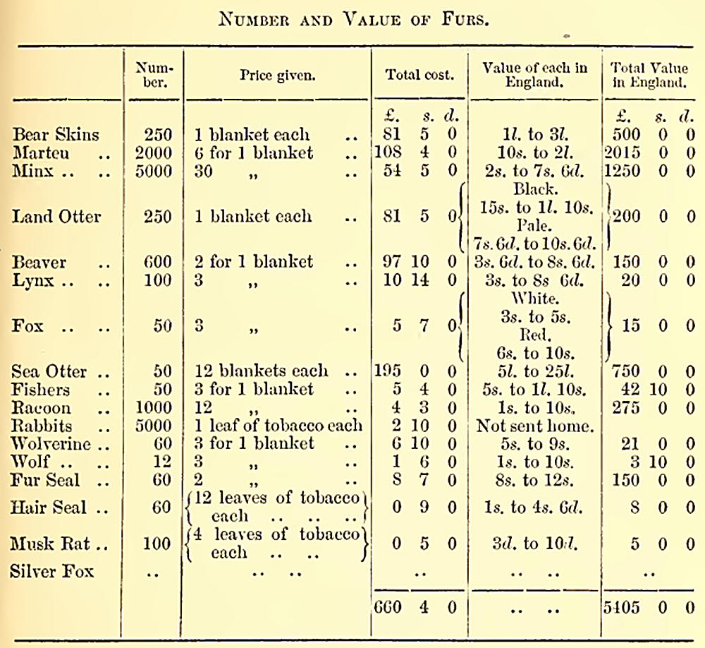
Having roughly estimated the cost of this station, I will give the
number and value of the furs and skins collected in the year 1859—by no
means an extraordinarily productive season. The following is a list:—
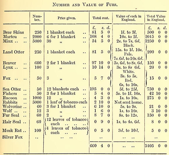
If, then, we add to the
cost of the furs 600?. for the expense of the post, we have 1260l.
against 5405l., showing a profit of more than 4100l. yearly on this
establishment, which is considered by the Company as one of their least
profitable stations.
From this balance of profit has to be deducted the cost of conveying the
above articles to England, which cannot well be estimated, as they are
conveyed in the Company’s own vessel, which carries passengers and other
freight. In addition to the above list of furs, above 400 gallons of
seal-oil are yearly exported from Fort Rupert.
Between Beaver Harbour and Cape Scott, at the extreme north of the
island, there are two or three anchorages—Shucartie Bay on the island,
and Bull Harbour in Hope Island, on the opposite shore. Just beyond Bull
Harbour a bank, called the Newittee Bar, has to be crossed, upon which,
however, there is always sufficient water for ships to pass over safely.
The Newittee Indians inhabit this part of the island, and coal has been
found by them in considerable quantity. I should have mentioned that
coal has been discovered at Beaver Harbour also, and, indeed, that
measures of this mineral extend all along the northern part of the
island.
Off Cape Scott, in Queen Charlotte’s Sound, is a small group of islands,
called the Triangles. These are high and rocky, and useless except
perhaps to erect a lighthouse on at some future day.
One hundred and twenty miles north of Cape Scott are the Queen Charlotte
Islands. These islands are as yet unsurveyed and unexplored. It is
generally thought that the group will be found to be divided into many
more islands than are at present given on the charts.
Very little is yet known of their character. The Haida Indians who
inhabit them are tierce, and rather disposed to resist the encroachments
of the whites. Some years ago, indeed, they fired on the boats of a
man-of-war approaching their shores. These Indians have at various times
brought specimens of gold in quartz to Victoria, and in 1852 the Hudson
Bay Company despatched a party of men in the brig ‘Una’ to examine the
place from whence they said it came. This party proceeded to Gold
Harbour, as it is now called, on the south-west side of Moresby Island;
and Mr. Mitchell, who commanded the ship, told me that they got about
1000 dollars of gold out, but that the Indians stole it from them as
fast as they collected it. The miners then growing weary of their task,
and quarrelling among themselves, the expedition broke up.
In July, 1859, Mr. Downie —whose name I have before mentioned as an old
Californian miner and explorer—started with a party of twenty-seven men,
provisioned for three months, and reached Gold Harbour on the 6th of
August. They examined the place where the gold was taken out by the
‘Una’s’ party, and discovered a few specks in a small quartz-seam
running through slate. They then explored Douglas Inlet, which runs into
the south of Gold Harbour, without any success; and afterwards proceeded
to Skidegate Channel, which separates the two large islands Graham and
Moresby. They found trap and hornblende rocks, with a few poor seams of
quartz, but no gold to the southward. To the northward they found
talcose slate, quartz, and red earth, but no gold ; and, coming upon
coal in the Skidegate Channel, decided further search was useless, and
returned to Gold Harbour. They had left some of the party there to
blast, and, on returning found that they too had given it up as
hopeless. The conclusion they came to as the result of their
investigation was, that the gold found by the first party existed in an
offshoot, or, as it is technically termed, a blow, instances of which
are very common in California. In his report of his journey to the
Governor, Mr. Downie says: “The offshoots in question are not uncommon,
as I have often seen them in California. On such a discovery being made,
hundreds of miners take claims in all directions near it, and test the
ground in every way; but nothing is found except in the one spot, about
seventy feet in length, running south-east and north-west. On being
worked about fifteen feet it gave out. . . . Before work commenced, I
have blown the sand off a vein of pure gold.” About the same time,
Captain Torrens also went with a party to prospect on Queen Charlotte
Island. They landed at the village in the Skidegate Channel, and’ were
very nearly being murdered there. One of the Indians commenced
haranguing the others, and incited them to murder the party by saying
they were come to rob them of their land. One of the chiefs, however,
stood by them, and enabled them to get to their canoes, and they escaped
unhurt, though several shots were fired after them. They crossed to Fort
Simpson, and, after remaining there a few days, were recalled to Queen
Charlotte Sound by a deputation of Indians from Gold Harbour. The part
however, soon became discontented, and having met with as little success
in their search for gold as Mr. Downie, refused to stay longer. Captain
Torrens, in his report of the expedition, writes: “The country north of
Skiddegate Channel is low and thickly wooded, receding, in one unbroken
level, towards a huge range of mountains about 30 miles off. Vegetation
is here luxuriant, and at intervals patches of open land occur, in which
the Indians have planted crops of turnips and potatoes.” His
party—originally twelve—had broken up at Simpson: six accompanying him,
three staying at Simpson, and two going with a chief named “Edensaw” to
Copper Island and the northern islands of the Queen Charlotte group. The
accounts from these latter were satisfactory, as they brought back
copper ore and quartz with sulphurets. In a letter which I have received
from Captain Torrens, narrating the details of his journey, he says that
these specimens gave, upon analysis—
1st. Copper, 96 lbs. to the ton; value about 7000 dollars (14007) per
ton.
2nd. Sulphuret of iron and gold, valued at 13,500 dollars (26007) per
ton.
As no blasting, however, was done to get these specimens, he very justly
thinks that they do not give any guide to the real value of the spot in
which they were found.
On the 17th of May the ‘Plumper’ reached Fort Rupert, where we found
everything quiet, on account of nearly all the Indians being away at
Shirwattie, on the mainland, catching “houlikin.” Haying been longer out
than usual this time, and our coal becoming exhausted, we left Rupert on
the 25th, and reached Nanaimo on the following day.
After a few days more work in the Gulf, we returned to Esquinialt on the
15th of June, where we heard that HALS. ‘Hecate’ had been ordered out to
relieve the ‘Plumper,’ and to continue the survey of the shores of
Vancouver Island and the mainland. |