|
July, 1859. — The
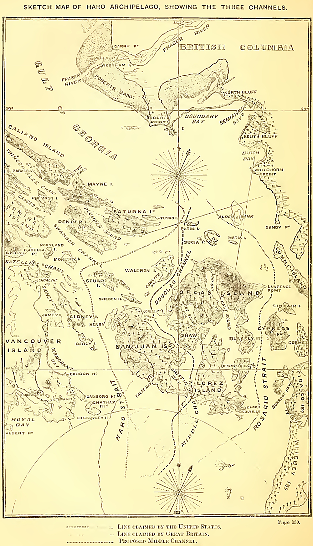
Boundary Commissioners had been all this while working to little effect.
The treaty concluded in 1844 between the English and American
Governments was, as I have before said, somewhat vague. It set forth
clearly enough that the boundary-line should follow the parallel of 49°
north latitude, to the centre of the Gulf of Georgia; but it was at this
point, as the reader may remember, that the difficulties attending its
interpretation began. Thence the treaty stipulated that the line should
pass southward through the channel which separates the continent from
Vancouver Island to the Strait of Juan de Fuca. The channel. But there
were three. Were the most eastward of these meant, such a construction
would give possession of all the islands of the Gulf to Great Britain.
On the other hand, should the line, as the American Commissioners
contended, be taken to pass down the Haro Strait, these islands would
pertain to them. Reasons, which I have previously given, exist which
prevent my making any remarks upon the merits of the matters in dispute
between the Commissioners of Great Britain and the United States, or the
results which followed them. I may only say, that it was at this time,
while the question had been referred by the Commissioners to their
respective Governments, that General Harney, who had lately been
appointed to the command of the United States troops in the territories
of Oregon and Washington, without any notice, landed soldiers upon the
island of San Juna, who still remain there.
The same reasons which keep me silent upon this proceeding of the
American General prevent my doing more than allude to the angry
excitement which it caused in the colonies and at home. The events of
that period will still he fresh in their memory of my readers. It will,
therefore, be remembered how nearly war between the two countries was
approached, and by what judicious and timely arrangements it
was-averted. I will merely remark, in conclusion, that, during the
present domestic troubles of the American people, this dispute is
temporarily shelved. San Juan is at present held by equal bodies of
troops of Great Britain and America, and the question remains open for
settlement at some future period.
August 5th.—The flagship arrived, with divers on board, who, upon
examining the ‘Plumper,’ found that she had received so much damage that
it was determined, so soon as the coming winter-work was finished, to
proceed to San Francisco, where the necessary repairs could be made.
August 19th.—A report reaching the Governor of some settlers in Burrard
Inlet having been seized and detained by the Indians, wo were despatched
thither to investigate this matter, but, upon our arrival, we found the
report untrue.
I will take the present opportunity of giving a short and general
description of the more important of those long arms of the sea, or
inlets, which, as a glance at the map will show the reader, stretch at
comparatively small intervals inland along the coast of British
Columbia. Some of these were not surveyed until a period considerably
later than the time of which I am now writing, while others are still
unexplored. It must be many years before these shores can be of any
value to the new colony; and it is mainly with the hope of discovering,
from the head of one of them, a more direct route or routes to the
gold-fields on the Upper Fraser than that afforded by the river, that
exploring parties have been, and still are, busy examining them.
All these inlets possess certain general characteristics. They run up
between steep mountains three or four thousand feet in height; the water
is deep, and anchorages far from plentiful; while they terminate, almost
without exception, in valleys,—occasionally large and wide, at other
times mere gorges,—through which one or more rivers struggle into the
sea. They may be said, indeed, to resemble large fissures in the coast
more than anything else. In the days of Vancouver these arms of the sea
were diligently searched in the hope of discovering through one of them
the long looked-for passage that should connect the Pacific and Atlantic
Oceans. It was not indeed until after many successive disappointments
that Vancouver seems to have relinquished this hope; and although of
course some inaccuracies have been found in his charts of these parts,
their general correctness, together with the amount of labour they must
have cost him, and the patience and perseverance with which he forced
his vessels through intricate passages difficult and dangerous even to
steamers, deserve more credit than he ever obtained.
The southernmost, and as yet the most important, of the inlets of
British Columbia was named, by Vancouver, “Burrard,” after a friend of
that name in the Royal Navy. This inlet differs from most of the others
in possessing several good anchorages. It is divided into three distinct
harbours, which are separated from each other by narrows, through which
the tide rushes, with such velocity as to render them impassable by any
but powerful steamers except, at slack-water or with the tide.
The entrance of Burrard Inlet lies 14 miles from the sand-heads of the
Fraser River. English Bay is the anchorage immediately inside the
entrance on the south side and is of considerable importance to vessels
entering at night, or when the tide is running out through the narrows,
affording them an anchorage where they can wait comfortably until
morning or turn of tide, instead of drifting about the place. Two miles
inside the first narrows is Coal Harbour, where coal has been found in
considerable quantities and of good quality, although the demand is not
yet sufficient to induce speculators to work it in opposition to the
already established mines at Nanaimo. Six miles above Coal Harbour, the
inlet divides again into two arms; one of which runs inland about ten
miles, the other opening into Port Moody, which forms the head of the
southern arm. Port Moody is a very snug harbour, three miles long, and
averaging half-a-mile wide, though only 400 yards across at the
entrance. It is the possession of this port, with its proximity by land
to New Westminster upon the Fraser River, from which place it is distant
but five miles, which gives to Burrard Inlet its present importance.
During the winter the Lower Fraser is sometimes frozen up, and the only
access to British Columbia then open is by the way of Burrard Inlet and
Port Moody. Hither the steamers have to take their passengers, mails,
and cargo; whence, by a short, good road, they are conveyed to New
Westminster. During last winter (1861-62), winch was unusually severe,
the Fraser was entirely blocked up; and this way, and an out-of-the-way,
inconvenient trail of seven miles from Mud Bay, inside Point Roberts,
were the only routes by which the interior of British Columbia could for
some considerable time be reached.
Immediately north of Burrard Inlet is Howe Sound, the north point of the
former forming the south shore of the latter. This sound runs inland for
about 20 miles, and is wider than the other inlets, having a breadth at
its entrance of six miles. At its head is a wide, extensive valley, the
soil of which is very good, and through which several rivers run into
the inlet: the largest of these, the Squawmisht, is navigable for 20
miles for canoes. From this point, which, however— so tortuous is the
river — is only distant ten miles from the head of the sound, a road
might, with no great difficulty, be cut to Port Pemberton, on the north
end of the Lilloett Lake, the distance being only 40 or 50 miles. I
examined this route in 1860, and found it perfectly practicable; but as
a road between Port Douglas, at the head of Harrison Lake, and the south
end of the Lilloett Lake had already been constructed, it was not
thought advisable to make another so near it. Had this route met the
Fraser above instead of below Cayoosh, it would have been worth cutting
at any expense; but coming out where it does, its construction would not
have been of sufficient benefit to the colony to have justified the
great outlay which must have been incurred in making it.
Next to Howe Sound is Jervis Inlet, a narrow arm running inland 45
miles. Vancouver appears to have thought this the most promising of all
the inlets he had explored for the great object of his search ; and
experienced great disappointment when, after sailing up it for several
days, he reached its head. It seems strange that such an experienced
explorer should have expected that so narrow a passage—its greatest
breadth after the first ten miles being but two— would be found to
divide the American continent from shore to shore.
It was for some time thought that a highway to British Columbia would be
found to exist up this inlet; and, with the view of ascertaining its
practicability, I was instructed to start from the head of Jervis Inlet,
and make my way to the Fraser Kiver. An account of this journey and its
unsuccessful issue will follow in its place. Whilst making it, I
constantly interrogated the Indians who accompanied me as to the
probability of a way existing from the head of Toba or Bute Inlets,
which run up from Desolation Sound, and arc the two next inlets
northward of Jervis. From their answers,
I was for some time under the impression that Bute Inlet was the place
whence a start might be made for the Fraser with every prospect of
success. But upon returning to Victoria, and submitting the accounts of
my informants to the scrutiny of an interpreter, and making them map out
in their own way the route that they suggested, I came to the conclusion
that the route they spoke of led, not to the Fraser Fiver, but to Lake
Anderson.
It may seem strange that Indians living at Jervis Inlet should know the
country about Desolation Sound so well, seeing that the two arms of the
sea are distant from each other 60 miles, and that the inhabitants of
each inlet are constantly at war. The tribe, however, to which my guides
belonged, although in the summer dwelling by the coast, were settled
really at Lake Anderson, from which neighbourhood they migrated to Howe
Sound, Jervis, Bute, and Toba Inlets, to fish, and were, therefore,
likely to be well acquainted with the country through which at such
times they must pass on their way to the coast. They were called
Loquilts, the proper Indians of Jervis Inlet being named Sechelts.
From these Indians I ascertained that the Bridge River, one—the
north—branch of the Lilloett, together with the Sqiiawmisht and the
Clahoose Kivers, which empty into Desolation Sound, all take their rise
in three or four small lakes lying in a mountain basin some 50 or 60
miles from the coast due north of Jervis Inlet. Mr. Downie, when
exploring Bute Inlet with a view to a way from the coast inland, went
four or five miles up the Clahoose River, which he described as large
and broad, running in a north-east direction. “The Indians,” he wrote,
“told me it would take five days to get to the head of it. Judging from
the way a canoe goes up such rivers, the distance would be about sixty
miles, and it must be a long way above the Quamish (Squawmisht), and not
far from the Lilloett. The Indians have gone this route to the head of
Bridge River, and it may prove to be the best route to try. It is very
evident there is a pass in the coast-range here that will make it
preferable to Jarvis Inlet or Howe Sound. If a route can be got through,
it will lead direct to Bridge River.”
It is now three years since Mr. Downie made the above statement; and I
think it is probable that he has long since changed the opinion he then
expressed as to the route to the Bridge River being the most practicable
and best of those proposed to the Upper Fraser. So little, however, is
known of this valley—and that little comes from Indian information —that
the route advocated by Mr. Downie may yet be found to equal his
expectations of it. Since my return from the colony it has been again
examined and adopted by a company, who propose at once to open it up. It
is asserted by them that this way is nearly twenty miles shorter than
the Bentinck Arm route to Alexandria, and that no serious obstacles
intervene to prevent striking the Fraser at a point where steamers can
be put on to ply on the Upper River. The right to construct this route,
and to collect tolls on the pack-trail for five years, at 1J cents per
lb., and 50 cents for animals—with, should a waggon-road be constructed,
5 cents per lb. toll—has been conceded to them. In their prospectus the
distance of the route proposed is set down as 241 miles, of which 83
miles are river and lake navigation, and 158 land-carriage, offering an
advantage over the rival route by Bentinck Arm, which has a longer
land-carriage. Before this summer is out, the question of superiority
will in all probability be settled. '
The next inlet, north of Bute, is Loughborough. Beyond are Knight Inlet
and Fife Sound, of which comparatively little is known. In 1861 Mr.
Downie went up Knight Inlet and discovered plumbago, which, when tested,
did not prove to be so rich as he at first sight thought it.
The entrance to Fife Sound is marked by a magnificent mountain on its
north side, which Vancouver named “Stephens,” after the then First Lord
of the Admiralty.
Above this point up to our coast boundary, in 54° 40' north latitude, is
a succession of inlets known only to the Indians who inhabit them, and
some of the Hudson Bay Company’s employes. One of these, through which
it is thought by many that the much-desired road to the interior of the
country will be found to lie, “ Deans Canal,” has recently attracted
considerable notice. The entrance to this inlet is about 80 miles from
the north end of Vancouver Island; it runs inland some 50 miles, under
the name of Burke Channel, and then divides into three arms: one, Deans
Canal, running nearly north for 25 miles; the others, called the North
and South Bentinck Arms, pursuing north-easterly and southeasterly
directions. By one or other of these channels it is pretty confidently
expected that a good available route to the interior will be found to
exist. No doubt attention was drawn to this spot not a little from the
fact, that years ago Sir Alexander McKenzie did actually penetrate from
the interior to the sea here. Subsequently it was known that a Mr.
McDonald had found his way from Fort Fraser to the coast, coming out at
Deans Canal, and, it was said, making the journey with ease and
expedition; while later, letters were conveyed more than once by some
such route, by Indian messengers, from the Hudson Bay Company’s steamer
'Beaver,’ lying in the Bentinck Arm, to the officer in charge of Fort
Alexandria, high up the Fraser River.
When Sir Alexander McKenzie explored this part of the country, he
appears to have ascended the West-road River from the Fraser, and then,
crossing the ridge forming the watershed, to have descended to the sea.
His route has never been exactly followed; but in 1860 Mr. Colin
McKenzie crossed from Alexandria to the same place on the coast, viz.,
Baseals’ Village, or Bell-houla Bay, in thirteen days by way of
Chilcotin Lake. His party travelled the greater portion of the way on
horseback: Mr. McKenzie told me that they might have taken their animals
all the way by changing the route a little. On their way back, indeed,
they did so. The ascent to the watershed was, he said, so gradual, that
they only knew they had passed the summit by finding that the streams
ran west, instead of east. Since that time another gentleman, Mr.
Barnston, has travelled by much the same route. His journey is described
in a letter which he wrote to Mr. P. Nind, Gold Commissioner at Cariboo,
in July, 1861, and which, as illustrating the character of the country
and the obstacles met with in the construction of trails, I am enabled,
by the kind permission of that gentleman, to give to the reader:—
“We left Alexandria on the 24th May last, and after the loss of several
days from accidental causes, such as missing trail, &c., arrived at Lake
Anawhim on the 8th June. We left this place on the 10th. On the 12th we
camped in the Coast Range. On the 13th we descended into the valley of
Atanaioh, or Bell-houla River, and camped a few miles down. Here we left
our horses with Pearson and Ritchie. On the evening of the 17th McDonald
and I, accompanied by Tomkins, started on foot for the coast. We arrived
at the Bell-houla village, Nout-chaoff, early on the morning of the
19th. Here we obtained a canoe and descended to Kougotis, the head of
the Bell-houla (North Bentinck Arm), in six hours. The cause of our
horses being left behind was the swollen state of the mountain-torrents
running into the Bell-houla River. These streams are, however, quite
small and narrow, and could be bridged at little expense. On the 24th we
left Kous-otis to return in the same canoe, and arrived at Nout-chaoff
on the 25th. The trail between the two villages is good. From
Nout-chaoff to camp it took us two days, a distance usually travelled by
Indians with packs in one. On the 30th we broke up camp on Bell-houla
River, and arrived in Alexandria on the 10th, travelling moderately with
packed animals. The Bell-houla River could be made navigable for
light-draught steamers as far up as Nout-chaoff, and perhaps above. From
thence pack-trains could make Alexandria, or the mouth of Canal River,
if a trail were made there, easily in 14 or 15 days. The trail to Canal
River would probably have to diverge from the Alexandria trail at
Chisikut Lake about 75 miles from Alexandria. The trail runs the whole
distance from Alexandria to Coast Range on a kind of table-land, which
is studded in every direction with lakes and meadows: feed is plentiful.
The streams are numerous, but small and shallow; in fact, mere creeks.
There are some swamps, which require corduroying. There is plenty of
fallen timber; but it is light and could easily be cleared. There is
also a kind of red earth, which is in places very miry; the cause of
this is I think, want of drainage. This miry ground and the swamps are
the greatest objections that can be urged against the road. The swamps,
however, have one advantage over such places generally,—that is, in
their foundation, which is rocky and strong. The trail might be
shortened in some places, but not a great deal. We made the distance
from our camp on Bell-houla River to Alexandria easily enough in 11 days
with packed horses. The trail is, with the exception of the descent of
the Coast Range, comparatively level, and could easily be made a good
practicable road. The descent on to the Bell-houla River is not by any
means steep, with the exception of a slide, down which we, however, took
our horses. This slide might be avoided, or could be easily overcome by
a zigzag trail. The trail would have to be considerably improved before
pack-trains could pass over it. When the Coast Range is passed there is
no perceptible ascent.
“From the place where you first strike the Bell-houla River in the Coast
Range, the trail runs along its bank through a deep gorge or pass in the
mountains the whole way to the coast. There is, however, another road
from Lake Anawhim, which strikes the river at Nout-chaoff, which the
Indians informed Us was the better road. They also told us that if we
had taken this road we could have reached Nout-chaoff with our horses,
as we should have thereby avoided the worst part of the other road and
the torrents. Kougotis, the head of the inlet, would be the head of
navigation for sea-going vessels.
“We think that if a road were made from the Bell-houla Inlet, to strike
the Fraser somewhere about the mouth of the Quesnelle River, and from
thence into the Cariboo, &c., a considerable saving in the cost of
transportation would be effected. We can hardly make an approximate
estimate even of what it would cost to make the trail passable; but it
would not cost much considering the distance and style of country, and
could easily be made available for next summer’s operations.”
If The reader will follow on the map the line between the Bentinck Arm
(Bell-houla) and Alexandria, he will see that it runs straight east and
west between the two places for 160 miles. This is the route to the
gold-fields, south of that taken by Sir A. McKenzie, which is proposed
to be adopted, and to open up which another company, in opposition to
the Bute Inlet scheme, has been organised. It is affirmed that the road
becomes open and practicable for animals in the beginning of April, and
that the snow at Bell-houla and the main plateau above it disappears
early in the year. At present and for some time to come no accommodation
for travellers can be expected along this route; but in reply to this
objection it is urged that the journey is comparatively short, and may
be walked without a pack in seven days; and that the Indians of the
various tribes through which it will be necessary to pass are not only
friendly but seem anxious for white settlers to come, inquiring
constantly when the Boston and King George men may be expected, and
looking forward to remunerative employment in packing to the mines.
The following account of this route has also been given by one of its
projectors, who assumes to speak from personal experience:—“My
suggestion would be, let a man take up sufficient provisions for the
road; or if he wishes to avoid the heavy outlay which a poor miner must
experience before he has struck a claim, let him take sufficient to last
him three or four weeks, and pack one, two, or three Indians, as the
case may be. I assure him he will find no difficulty in procuring
Indians. Nootlioch (an Indian lodge) is 30 miles up the river; for 15
miles above this goods can be taken in small canoes. Narcoontloon is 30
miles; a good road with the exception of one bad hill. Here there is
another Indian lodge, from which it is 50 miles to Chilcotin; good
trail, perfectly level. From there it is 60 miles to Alexandria, or
about 70 to the mouth of Quesnelle River. The trail from the top of the
Nootlioch hill is for foot-passengers as good the whole way as any part
of the Brigade Trail, with the exception of one or two places, where
there is a little fallen timber. The trail follows a chain of lakes, and
could consequently, if taken straight, be made much shorter, and also
avoid much soft ground. Game and fish are abundant on the road: I caught
several trout with a string and a small hook and a grasshopper on my way
down. The Aunghim and Chilcotin Indians have a good many horses, which
might be turned to use for packing.”
Alexandria, however, which is the proposed terminus in this route from
Bell-houla, is some 50 or 60 miles south of those diggings, which are
now the most profitable in the country, and which, under the general
name of the Cariboo gold-fields, extend from the lake of that name to
Bear River, and are likely to extend still farther north, should the
opinion of many of the miners that the richest diggings still remain to
be found on the Peace River, northward of that spur of the Rocky
Mountains, which turns the course of the Fraser southward, prove
correct. It seems, therefore, likely that the line of route proposed by
other adventurers, running from Dean’s Canal, in a north-easterly
direction, to the Nachuten Lakes, and along the river of the same name
to Fort Fraser, may bear off the palm, particularly if, as is very
probable, Stuart River be found navigable for steamers from that place
to Fort George, where it meets the Fraser.
In the summer of 1859 Mr. Downie explored a still more northward route
from Fort Essington, by a river called by him the Skena, but which must
be the same as that known inland as the Simpson or Babine, and which
flows from Lake Babine. This route is less direct than any of the
others, and is so far north as to be unavailable for the greater part of
the year. Mr. Downie’s interesting account of this journey will be found
in the Appendix. It will be seen that he reports the country through
which he travelled to be auriferous, that ho found evidence of most
extensive deposits of coal of a quality superior to any specimen of that
mineral which he had previously seen in British Columbia and Vancouver
Island, and that the land generally seemed excellent and well adapted
for agricultural purposes.
Forty miles north of Port Essington, and 240 from the north end of
Vancouver Island, Fort Simpson is reached, which is situated as nearly
as possible upon the line of boundary between Great Britain and Russia.
This post has been established for many years, and is surrounded
somewhat thickly by Indians, among whom Mr. Duncan; the missionary
teacher, of whose self-denying life and valuable labours I shall
hereafter have occasion to speak at greater length, works with such
singular success.
From the 25th August to the 30th September we were employed among the
inner channels between Nanaimo and Victoria, and in putting down a set
of buoys on the sands at the entrance of the Fraser River. On the
islands in these inner channels there are now several agricultural
settlements, the principal one being on Admiral Island, an island
fourteen miles long by four or five wide, having two or three excellent
harbours, and containing much good land. On this island there are
saltsprings.
Admiral Island is next to Vancouver, from which it is separated by a
narrow strait, called Sausum Narrows, which at its narrowest part is
little more than half-a-mile Avide.
Four miles west of the south part of Admiral Island, Cape Keppel, is
Cowitchin Harbour. As a harbour this is not worth much; but it will be
of importance when the Cowitchin Valley, which runs back from it,
becomes settled. This valley is the most extensive yet discovered on the
island, and is reported by the colonial officers who surveyed it to
contain 30,000 or 40,000 acres of good land. It is peopled by the
Cowitchin tribe of Indians, who, as I have mentioned, are considered a
badly-disposed set, and have shown no favour to those settlers who have
visited them valley. Although it has been surveyed it cannot yet be
settled, as the Indians are unwilling to sell, still less to be ousted
from their land. Through this valley runs the Cowitchin River, which
comes from a large lake of the same name, and 24 miles inland, and
empties itself into the head of Cowitchin Harbour. It is navigable for
several miles for canoes. Between Cowitchin and Nanaimo there is a
considerable quantity of good land, Avhicli has been surveyed and is
called the Chemanos district.
Immediately south of Cowitchin Harbour is the Saanich Inlet, a deep
indentation running 14 miles in a south-south-east direction, carrying
deep water to 'its head, and terminating in a narrow creek within four
miles of Esquimalt Harbour. This inlet forms a peninsula of the
south-east portion of Vancouver Island of about 20 miles in a
north-north-wesl and south-south-east direction, and varying in breadth
from eight miles at its southern part to three at its northern. On the
southern coast of this peninsula are the harbours of Esquimalt and
Victoria, in the neighbourhood of which for some five miles the country
is pretty thickly wooded—its prevailing features lake and mountain—with,
however, some considerable tracts of clear and fertile land. The
northern portion for about ten miles contains some of the best
agricultural land in Vancouver Island. The coast here, as everywhere
else, is fringed with pine; but in the centre it is clear prairie or
oak-land, most of it now under cultivation. Seams of coal have also been
found here. On the eastern or peninsular side of the inlet are some good
anchorages, the centre being for the most part deep. A mile and a half
from the head of the inlet is a large lake, called Langford Lake, which
is very likely to be called into requisition some day to supply the
ships in Esquimalt Harbour, from which it is two miles and a half
distant, with water. Outside the Saanich peninsula is Cordova Channel,
extending to Discovery Island, seven miles from Victoria. Like all these
inner passages, this one is quite safe for steamers, but, from the
varying currents, dangerous for sailing vessels. As several farms have
been established along the shore of the island here, looking out on the
Haro Strait, and the land is much more clear than usual, this is one of
the prettiest parts of the island.
On the 30th September the Admiral (Sir R. L. Baynes, K.C.B.), came on
board, and we took him to Nanaimo and Burrard Inlet, returning to
Esquimalt on the 4th October. From this time until the 28th we continued
working northward from Nanaimo, when, having been drenched to the skin
nearly every day for a month, the captain determined to close the
season’s operations, and we made for Nanaimo. Here we found—what was not
unfrequently the case—that the Indians were all more or less drunk,
owing to a grand feast which had been given by the chief of the tribe a
few days before, and that they would not get the coal out of the pit for
us: we had, therefore, to help ourselves.
On the 10th of February, 1860, having brought our winter duties to an
end, we started for San Francisco, and anchored that night in Neali Bay,
of which I have spoken in describing the Strait of Fuca. Next morning we
proceeded out of the Strait, passing several vessels on their way in.
The sight of these vessels could scarcely fail to remind us of the
colony which had sprung into existence since we had rounded Cape
Flattery and entered that Strait three years before, when we might have
steamed up and down it for a week without meeting more than a few
vessels, and those bound to American ports. In the passage between San
Francisco and Vancouver Island there is nothing worthy of particular
notice, except the change from the everlasting pine-trees which friDge
all our shore, to the almost treeless coast of California. One cannot
help feeling that Nature has been unfair in its distribution of timber
in these regions. California, comparatively speaking, may be said to
have none, all their plank being supplied from the saw-mills before
spoken of as being at work in Puget Sound and Admiralty Inlet. It was
with considerable difficulty and at great expense that they managed to
get sufficient wood to build a small steamer, ordered by the Federal
Government to be constructed at Mare Island, the dockyard of San
Francisco. The coast all the way down is well lighted, but there are no
good harbours; San Francisco, indeed, is the only good one between the
Strait of Fuca and Acapulco, which is 1500 miles below it, on the coast
of Mexico, although there are several open anchorages. The distance from
Cape Flattery to the Golden Gate, as the entrance of San Francisco
harbour is called, is 700 miles, and the mail-steamers make the passage
generally in three days and a half to five days. We, however, were under
sail much of our time, and did not make it until seven days after
leaving Esquimalt. On the morning of the 17th we sighted the noble head,
the name of which has been changed from “Punta de Los Reyes”—the grand
name the old Spaniards had given it—to “Point Reyes”—and crossing the
bar, entered the harbour at four in the afternoon. .
Nothing can be finer than the entrance to this magnificent harbour; and,
considering also the country of which it is the only port, its name of
“Golden Gate” is very appropriate, although the name was given to it
long before the discovery of gold in California. It had reference, no
doubt, to the beauty of the country generally, and to the golden
appearance it wears in spring, before the parching summer sun has
scorched its verdure.
Fifteen miles off the harbour is a group of rocky islands, called the
Farrallones, on the southern of which is a lighthouse. Off the entrance
of the harbour is the “Bar,” on which the surf is generally rough. This
bar, however, serves to let the mariner know he is off the entrance if
he is trying to make the harbour in a fog; which, as they prevail
constantly from May till October, he is very likely to do. The current
in the entrance varies from two to five knots. There are two lighthouses
at the mouth of the harbour, and on the hill above, on each side, is a
telegraph-station. The constant fogs make this of little use, as ships
are always slipping in and out without their arrival or departure being
known. When we went in H.M.S. ‘ Hecate/ in October, 1861, nobody knew
anything of our arrival till some of the officers appeared at the club.
Generally speaking, however, vessels arriving are seen as they pass
Alcatraz Island, which lies in the middle of the harbour, and is a
military station. Although some attempt has been made to fortify San
Francisco, it is still very imperfect in this respect. The only
defensive works as yet existing are, a brick fort on the south side of
the entrance, intended to carry 140 guns, in three tiers of casemates,
and one tier en barbette. A battery, intended to mount eleven heavy
guns, is being constructed on the hill above this fort. Alcatraz Island,
in the middle of the harbour, is partially fortified; and as the guns on
this island are 150 feet above the sea, it would be an awkward place to
attack with ships. This island is about three miles and a half from Fort
Point; it is a small place, about 550 yards long, by 150 yards wide.
Their guns are all en barbette, and number about 100. There is no water
on the island, and they have to supply it from Saucehto Bay, five or six
miles distant, and keep it in a large tank, said to hold 50,000 gallons.
I had last visited San Francisco in 1849, when the gold-fever was at its
height, and there were only a dozen houses in the place, the 5000 or
6000 inhabitants being scattered about in tents. At that time the site
of the present magnificent city was a bare sand-hill. In those days the
harbour was filled with merchant-ships, as now; but although they
entered in great numbers, few went out, both officers and men deserting
the ships for the diggings as soon as the anchors were let go, and
leaving their cargoes to be unloaded by others. Where these vessels used
then to be anchored fine streets have been erected, for all the lower
part of San Francisco is built out over the harbour. Many accidents are
constantly occurring from the insecure way in which these streets are
left. It is dangerous to go down to the wharves after dark, from the
large holes left exposed, through which many poor fellows have fallen
and been killed. Constant actions are being brought against the Town
Council on this account. Greenhow, the American historian, was killed by
falling through one of these places, and his widow brought an action
against the Town Council, recovering the sum of 10,000 dollars for her
loss.
San Francisco has been twice burnt down in the twelve years during which
it has been in existence. These fires have been most beneficial to the
town, as most of the wooden buildings which were destroyed have been
replaced by very fine brick ones. Montgomery Street, the principal
thoroughfare in the town, is now almost as fine a street as any European
capital can boast of; equal, indeed, in the size of the buildings and
magnificence of the shops, to the best thoroughfares of London. No city
in the world has, I imagine, a history so short and wonderful as San
Francisco. In February, 1849, the population was about 2000: in the
middle of the same year it had risen to 5000; while it is stated that
from April, 1849, to January, 1850, nearly 40,000 emigrants arrived, of
which only 1500 were women. By the year 1860, the population had risen
to 66,000. In addition to these, thousands went to the mines direct,
many crossing the continent and the Sierra Nevada, where hundreds left
their bones to bleach among the mountains.
Among the thousands who hurried to California from every part of the
world, it may be imagined there were many of the very dregs of society.
Convicted felons from our penal colonies—every one, indeed, whose own
country was too hot for him, hastened hither. Murders, incendiarisms,
and every kind of crime were being daily perpetrated; no decent man
dared to walk the streets after dark, and no property was safe. Law
there was not; and where two-thirds of the population were scoundrels,
it may be imagined what class of public officials would be elected under
the system of universal suffrage. What, therefore, between the weakness
or partiality of the judges, the technicalities of the law, the
dishonesty of the juries, and the dread of witnesses to tender their
evidence, San Francisco, in 1851, was suffering from anarchy
unparalleled in modern history. It was this social condition of the city
that caused the organisation of that most remarkable society, the
“Vigilance Committee,” to which I have had occasion to allude in a
former chapter.
This association was formed in June, 1851, “for the protection of the
lives and property of citizens resident in the city of San Francisco.” A
council was appointed and a place of meeting fixed, while the tolling of
the bell of the Monumental Fire Engine Company was the signal for
assembly. Although the “Vigilance Committee” has for several years now
allowed the law of the land to take its course, it still exists, and is
ready to assemble whenever the signal may be given. “What has become of
your Vigilance Committee,” I asked one of them when I was in San
Francisco in October last. “Toll the bell, Sir, and you will see,” was
the reply. “Oh, then you are still under orders?” “Always ready at the
signal, Sir. If it were now given, you would see thousands at the
meeting-place before the bell had ceased to sound.”
There is no doubt that this strange organisation exercised, and still
exercises, a most wholesome restraint over a society that, but a few
years since, elected a miner to be chief judge of the State, and whose
two principal judges now go by the significant sobriquets of “Mammon”
and “Gammon.” The first proceeding of the committee in the summer of
1851 was to arrest, try, and hang four men, three of whom confessed
their crimes, while the fourth was, I believe, undoubtedly guilty. The
moral effect of this proceeding was wonderful. All the other towns,
which were rising all over the State, formed Vigilance Committees of
their own. Many known ruffians, whose crimes could not be brought home
to them, were ordered to leave the State; while others were kept in
surveillance, and reported from Committee to Committee as they traversed
the country. For years after this California was almost free of crime.
Although by the greater number of the people the Vigilance Committee was
held in favour, the officials and some others denounced it, and to this
day stigmatise its existence as a disgrace to California. These termed
themselves the “Law and Order ” party; but upon many occasions their
weakness to restrain the mixed and dangerous population of San Francisco
was made apparent.
I have entered more fully into the history of San Francisco than I
otherwise should have done, since I think a valuable and fair comparison
may be drawn between these scenes and the peaceable course of British
Columbia since the discovery of gold there five years ago. The reader
unacquainted with the past history of California, would scarcely credit
the fearful scenes through which she has reached her present growth.
If San Francisco were
the only city in California, its dimensions would not, perhaps, be so
surprising; but it is only one of many, almost as large and equally
beautiful, in the State. Sacramento, the seat of government, Stockton,
and others, vie with it in size, while Marysville, Benicia, Los Angelos,
&c., are far more beautifully situated.
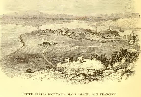
After a few days’ stay off San Francisco, we proceeded to Mare Island,
where the Government dockyard is established. Mare Island is 23 miles
from San Francisco, across San Pablo Bay, and at the mouth of the
Sacramento. Here we were received by the American naval officers, and
immediately put on the dock.
It may be interesting to some of my readers if I here say something of a
Sectional Dock, such as that we were now placed upon, and which, though
generally used in America, is very little known, and still less liked,
in this country. In a new country where there is plenty of timber, this
kind of dock has one great advantage, in its cheapness and facility of
construction, compared with the ordinary stone docks. But in California,
where, as I have before said, there is very little timber, a stone dock
might have been constructed almost as cheaply. The dock of which I am
speaking had to be built at Pensacola, and then taken to pieces, and
sent out to California at an expense, I was there told, of about 70,000
dollars (15,000l.)
The Sectional Dock is composed of a series of sections, or iron tanks,
each being fitted with a complete pumping-apparatus, elevated on a
framework 60 or 80 feet above the top of the tank. These tanks are
fitted with gates, like the caissons used in English docks, so that they
can be filled, sunk, or again puruped out at pleasure. A number of these
sections, varying according to the weight and length of the ship to be
lifted, are securely chained together, and the whole is moored in water
sufficiently deep to allow of their being sunk beneath the vessel’s
keel. They are generally kept level with the water’s edge; but when a
vessel is to be docked, they are sunk low enough to allow her to come
over the blocks which are placed along the centre. The vessel is then
hauled over the blocks, the pumps started, and, as she rises, shores
from the sides of the tanks, and from the frames of the pump-houses, are
placed under her and against her sides, and she is gradually raised till
her keel is out of the water. If proper care is taken, these docks are
quite safe, but the ship must be placed cautiously on the blocks, or an
accident is very likely to happen. In 1860 H.M.S. ‘Termagant’ was
allowed to fall over in this dock, and was for some time in great
danger. Her stern was allowed to rest on the edge of one of the
sections, which, as her weight came upon it, rose up and turned over.
This canted the ship, and she fell with her masts against the
pump-houses. Fortunately she had only been raised a little way; had she
been further out of the water, she would probably have broken down the
pump-houses, and very likely sunk. One advantage possessed by these
docks is, that the ship being, as it were, raised into the air, there is
better light for working at her bottom than in a stone dock.
While at San Francisco we had, of course, many opportunities of
remarking those peculiar habits of manner and phraseology indulged in by
the Americans. At Victoria, peopled as it is by Americans, we had been
made familiar with them; but here they were more commonly and glaringly
used. Certainly, they justify anything that Mr. Dickens or other English
satirists have written of them. Americans all say—not, however, with
perfect truth—that these eccentricities belong only to the lower orders
of society. I have the pleasure of knowing both American gentlemen and
ladies quite free from their use; but still I have met many others,
holding good positions in society, thoroughly “Yankee” in tone and
expression. These Americanisms must lose much of their ludicrous effect
by being written, as it is impossible to give the tone and peculiar
emphasis of the speaker. Words are often used by them to convey a sense
entirely different to that which we apply to them. Thus, “I’ll happen in
directly” is considered rather a good expression for a contemplated
visit. So, “clever” does not imply any talent in the individual of whom
it is spoken, but is said of a good-natured, gentlemanly man generally;
while “smart” answers for our “clever.” Speaking to an American naval
officer, just before leaving Victoria for San Francisco, he said, “Well,
sir, I guess you’ll have quite an elegant time down there. Elegant
place, sir, San Francisco.” A very pretty young lady, living in Puget
Sound, and happening to be on board the ‘Plumper,’ said to one of the
officers: “Well, sir, if you come over to Steilacoom, I guess you shall
have a tall horseback rideby which form of expression she meant to
imply, not that the horse should be longer in the legs than is usual,
but that care should be taken that the ride should be more than
ordinarily agreeable. In a book on Americanisms, published last year, a
Baltimore young lady is represented as jumping up from her seat on being
asked to dance, and saying, “Yes, sirree; for I have sot, and sot, and
sot, till I’ve nigh tuk root!” I cannot say I have heard anything quite
equal to this; but I very well remember that at a party given on board
one of the ships at Esquimalt, a young lady declined to dance a “fancy”
dance, upon the plea, “I’d rather not, sir; I guess I’m not fixed up for
waltzing—an expression the particular meaning of which must be left to
readers of her own sex to decide. An English young lady, who was staying
at one of the houses at Mare Island, when we were there, happened one
evening, when we were visiting her friends, to be confined to her room
with a headache. Upon our arrival, the young daughter of our host—a girl
of about twelve—went lip to her to try to persuade her to come down.
“Well,” she said, “I’m real sorry you’re so poorly. You’d better come,
for there are some almighty swells down there!” A lady, speaking of the
same person, said, “Her hair, sir, took my fancy right away.” Again,
several of us were one day talking to a tall, slight young lady about
the then new-fashioned crinoline which she was wearing. After a little
banter, she said, “I guess, Captain, if you were to take my hoops off,
you might draw me through the eye of a needle!”
Perhaps one of the most whimsical of these curiosities of expression,
combining freedom of manner with that of speech, was made use of to
Captain Richards by a master-caulker. He had been vainly endeavouring to
persuade the Captain that the ship required caulking, and at last he
said in disgust, “You may be liberal as a private citizen, Captain, but
you’re mean to an almighty pump-tack! ”—in his official capacity, of
course. Again, an American gentleman on board one of our mail packets
was trying to recall to the recollection of the mail agent a lady who
had been fellow-passenger with them on a former occasion. “ She sat
opposite you at table all the voyage,” he said. “Oh, I think I remember
her; she ate a great deal, did she not?” “Eat, sir!” was the reply, “she
was a perfect gastronomic filibuster!” One more example, and I have done
with a subject upon which I might enlarge for pages. The boys at the
school at Victoria were being-examined in Scripture, and the question
was asked, “In what way did Hiram assist Solomon in the building of the
Temple?” It passed two or three boys, when at last one sharp little
fellow triumphantly exclaimed, “Please, sir, he donated him the lumber.”
Hardly less remarkable than their peculiarities of language is their
habit of taking drinks with remarkable names from morning till night. No
bargain can be made, no friendship cemented—in fact, no meeting can take
place—without “liquoring up.” The morning is commenced with a brandy, or
champagne, cocktail, not infrequently taken in bed. This is continued,
at short intervals, until bedtime again, and no excuse will avail you
unless you can say you are a “dashaway,” which is their name for a total
abstainer. This habit, I must say, does not extend so high in the social
scale as the other; it is, however, the great social failing of the
Western States.
The repairs of the ship were finished, and on the 9th March we left San
Francisco to return to our work; little thinking that in scarcely more
than a year we should revisit it again with another ship in a worse
state than we had brought the ‘Plumper.’ |