|
March 31st, 1859.—From
this time until the 7tli of April, the £ Plumper ’ was busy surveying
the Harbour of Victoria. On the 10th we sailed for Nanaimo, and then
across the Straits to Fraser River, where we met the 'Satellite,’ and
embarked from her the Marines who had come over in the 'Tribune,’ and
twenty Engineers, whom we had orders to land at New Westminster, which
place had since our last visit become the head-quarters of what military
force was stationed in British Columbia.
Shortly before leaving Esquimalt upon this mission, the Governor had
requested Captain Richards to send one of the Officers of the 'Plumper’
up the Fraser River, to make a running survey of those parts of it then
occupied by miners, and to report upon it generally; and I was ordered
to undertake this task, Dr. Campbell, assistant-surgeon of the ship,
accompanying me. The programme which was sketched out for me by his
Excellency was, to ascend the Fraser as far as Cayoosh (now Lilloett),
returning thence by the Harrison and Lilloett trail. Discretion,
however, was given me to modify this route, if it should appear to be
desirable.
From Victoria to the entrance of the Fraser, the distance by water. is
ninety miles. At present I will only speak of the western passage by the
Canal de Haro, as it is generally if not always used. Starting from
Victoria, a ship rounds
Discovery Island, the smaller river-steamers passing inside, and then
turning up the Canal or Strait of Haro. This island was called by
Vancouver after his ship; indeed, almost all these places were named
before our arrival there. It is very easy to distinguish between the
parts named by Vancouver or by the Spanish explorers Galiano and Valdes.
Thus, although the eastern channel through the islands was called Canal
del nostra Senora de Rosario, the presence of the English at the same
time is obvious, from the fact that we find spots in it bearing such
names as Cypress Island, Strawberry Bay, &c. So the earliest passage of
the Spanish ships up the Strait of Haro is evident from the islands and
bays bearing names such as San Juan, Cordova, and Saturna. Again, we
need not ask the nationality of the voyager who named Admiralty Inlet;
and we know that Puget Sound, now in American territory, owes its
appellation to one of Vancouver’s officers of that name.
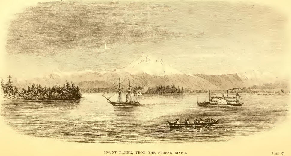
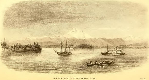
Should the day be clear, the traveller rounding Discovery Island obtains
a magnificent view of the mainland, with the snow-capped peaks of Mounts
Baker and Rainier towering in the distance. Under such favourable
circumstances, the view of Vancouver Island is exceedingly attractive,
the otherwise barren shore being pleasantly diversified with the houses
and buildings of the few farmers who have settled here, and brought the
land into cultivation. Upon the Island of San Juan also, which is passed
in crossing to the Fraser, may be seen the buildings of the Hudson Bay
farm rising in the midst of the green prairie that forms the southeast
end of that island. Leaving San Juan, the steamer’s course passes
through a pretty little group of islands which lie on the west of the
strait, up Plumper Sound, through Active Passage, a narrow passage
between Galiano and Mayne Islands, by taking which a considerable saving
of time and distance is effected, and so out into the Gulf of Georgia
opposite Point Roberts.
When the first rush to the diggings commenced, Point Roberts, upon or
near which there was no house nor any symptom of one being built, was at
once fixed upon as the site of an important “city;” and half-a-dozen
buildings sprang up on the flat in front of the bluff, where, while the
stream of boats and canoes was pouring up the river, they drove a brisk
and flourishing trade in whisky especially. But when the rush subsided,
and steamers took the place of the boats and canoes in which the
earliest miners had made their hazardous passage from Victoria, Roberts
found its occupation gone, and nothing but the remains of two or three
log-huts marks the site of the departed city.
In crossing the Gulf of Georgia, there may frequently be seen, as the
Fraser is neared, the line of the fresh and salt waters very clearly
defined. And this, indeed, is almost the only sign that a river is being
approached. From Point Roberts to Burrard Inlet, a distance of 28 miles,
the coast is low and swampy, the trees appearing to form so thick and
unbroken a line, when looked at from the Gulf of Georgia, that
Vancouver, carefully as he examined this coast for all inland waters,
penetrating every inlet under the impression that some day he should hit
upon the one that should conduct him into Hudson Bay, sailed past the
mouth of the Fraser without the least suspicion of having passed a river
at all.
The sand-bank at the entrance of the Fraser is called the Sturgeon Bank,
from the number of those fish caught by the Indians upon it. It extends
from Point Grey, the southern entrance to Burrard Inlet, to Point
Roberts, but does not join the hitter, leaving thus a small space
available for anchorage on its west side. This bank, and the entrance to
the Fraser river generally, have been most unfairly compared to the
Columbia. But there is really no point of resemblance between them. The
Columbia is one of the most dangerous bar-rivers in the world, and one.
upon which vessels are constantly lost. The captains of the mail-packets
consider the passage of this bar the only real danger in the voyage from
San Francisco; they always batten down everything on going in or out,
and are accustomed to wait three or four days, and sometimes even
longer, for fine weather before they will come out of the river. Nor is
this at all surprising when it is considered that it has the whole drift
of the Pacific upon it; while, upon the other hand, the Fraser is
perfectly sheltered from the sea by Vancouver Island. Indeed it is not
uncommon to hear a settler of British Columbia, between which and
Vancouver Island much rivalry exists, make the assertion that the sole
use evidently intended by Nature for that island was to form a
breakwater for the Fraser River and the other inlets of the mainland.
This is in fact so true, that although there is no little risk of a
vessel grounding in going in or out of the river, there is little, if
any, further risk; and if she touches at low, or at anything but high
water, as the ‘Plumper’ did several times, the greatest hardship is a
few hours’ delay until the rising tide floats her off. Vessels ground
constantly, sometimes from bad pilotage, and very often from the buoys
having shifted with the sands, but they rarely if ever receive any
damage; while, on the Columbia, if a sailing vessel grounds she is
almost certain to be lost; and even a steamer touching is liable to be
caught by the heavy sea and pooped, and very likely to be lost.
A petition has been presented to the Governor by those interested in the
navigation of the Fraser, to cause a buoy and light-vessel to be placed
at the sand-head. When this is done, there will be no difficulty in
entering the river; but at present the most careful and experienced
master of a ship is liable to be deceived by the buoys which get drifted
from their places, either by the sands shifting or by the large trees
which are constantly being borne down the river. The bad character
which, owing to these causes, has attached to the entrance of the Fraser
has been most detrimental to the interests of British Columbia. The
underwriters affix as high a rate of insurance upon ships clearing for
New Westminster as they do upon those bound up the Columbia. Having
assisted in making the surveys of this coast, I have no hesitation
whatever in saying that I would as soon take a vessel over the Fraser
Bar to New Westminster, as I would, into Victoria, as far as risk of
loss is concerned.
Before describing those parts of the Fraser which I visited in detail,
it will be well, perhaps, to give a general idea of this river and the
country adjacent.
The Fraser River rises in the Kocky Mountains, a little to the northward
of the Athabasca Pass, and in a straight line less than 800 miles from
its meeting with the waters of the Pacific in the Gulf of Georgia. From
its source it takes a north-westerly direction for about 160 miles, when
it is turned southward by a spur of the Bocky Mountains, which runs east
and west nearly to Stuart Lake, where it turns northward and assumes the
name of the Peak Mountains. On the other side of this spur rises the
Peace River, which from this point runs northward 130 or 140 miles till
it meets the Finlay Biver, and thence flows eastward through the Rocky
Mountains. I have called the reader’s attention particularly to the
Peace River, as it is towards it that the gold is now leading the
miners, and in it and its tributaries that many expect the richest
diggings will be found. This mountain-spur, as I have said, turns the
Fraser sharply round to the south, and it then forces its way in
torrents and rapids through the several great parallel valleys that
intersect this region in a direction a little east of south for 300
miles, till it reaches Hope, from whence it runs nearly east and west
for about 80 miles to its mouth.
About 45 miles below the upper turn of the river is Fort St. George. I
said about 45 miles, for in this country the positions are as yet very
roughly ascertained, and I take this opportunity of saying tliat all the
distances I mention on the river are only approximate.
Fort St. George, a Hudson Bay post, is situated on the west bank of the
Fraser River at its junction with the Stuart Biver, which latter flows
in a like direction from Stuart Lake, which is the southern post of a
chain of three or four lakes which stretch northward 100 miles to the
headwaters of the Bear River, at the foot of the Peak Mountains. At the
head of the upper of these lakes stands Fort Connolly.
Lying north-west from the head of Stuart Lake, and divided from it by a
narrow ridge, is Babine Lake, on which there is another Hudson Bay
Company’s post, and from which rises the Simpson or Babine River which
thence flows westerly, running into the sea just above Fort Simpson, and
as nearly as possible on our northern boundary on the coast. Forty miles
up the Stuart River it is met by a stream coming from Fraser Lake, which
is a small lake thirty miles south ward of Stuart Lake, and on which is
situated Fraser Fort, The stream between the Fraser Lake and Stuart
River, which I believe has no English name, receives on its course the
waters of the Natchuten Lakes and some others. I shall have again to
speak of all these lakes and posts, and will now, therefore, pass on
without further noticing them.
Five-and-forty miles below St. George is the West-road River, of no
particular note at this time; but better known to geographers than the
other streams, from the fact of Sir Alexander McKenzie having in the end
of the last century gone by it to the coast.
Another distance of 45 miles brings us to Fort Alexandria, the
head-quarters of the district for the Hudson Bay Company, and better
known than the other posts to the miners as being the nearest one to the
Quesnelle and Cariboo diggings. What is now called the Cariboo country,
so named from a species of deer found there in large numbers,1 lies
between the parallels of Alexandria and Fort St. George, and east of the
Fraser River.
Cariboo Lake is 30 miles north-east of Alexandria, and from that point
up to near Fort St. George, in the north, stretch the Cariboo diggings,
with their various local names of Williams Creek, Antler Creek, Canon
Creek, &c.
Nearly in the same latitude as Alexandria, and 30 miles east of it, are
the Quesnelle Lakes, where gold was found and worked in considerable
quantities in 1859. There are two of these lakes, one running southward,
the other east for some distance, and then north-east until it nearly
meets the headwaters of Canoe Biver. The first of these lakes is
estimated by those who have traversed them at 70 miles in length, the
latter at 100.
Thirty miles below Alexandria, on the east side of the Fraser, is a
stream running in a south-westerly direction from several lakes, of
which the principal are Williams Lake, Lac la Hache, Horse Lake, Lac
Tranquille, &c. Twenty miles below this again, and consequently 50 from
Alexandria, is the Chilcotin River, which runs in a north-east-by-east
direction to the lake of the same name, at the south end of which stand
the remains of an abandoned Hudson Bay Company’s fort.
Sixty miles below the mouth of the Chilcotin we come to the Pavilion,
situated on the opposite or east bank of the river.
From this point downwards I am enabled to describe the river from
personal experience. At Hope, it assumes the character of a navigable
stream, steamers of light draught reaching this point, and even Yale, 15
miles further up.
In June, July, and August, the melting of the snow causes the river to
rise so rapidly and makes the current so strong that it requires a very
powerful steamer to stem it. It is during these months that numbers of
large trees are brought down from its flooded banks, offering a serious
obstruction to navigation, many of them ultimately fixing themselves in
the stream and becoming “ snags.” Between Hope and Langley —the latter
30 miles from the river’s mouth—there is always a current ranging from
four to seven knots; but at Langley the river becomes a broad, deep, and
placid stream, and except during the three summer months (June, July,
and August) the influence of the flood-stream is felt there. The current
is not more than three knots and the depth of water ten fathoms, so that
vessels of any draught may conveniently anchor.
Vessels of from eighteen to twenty feet draught may enter the Fraser and
proceed as high as Langley, or even a few miles above it, provided they
have steam-power.
The river is at its lowest stage during the months of January, February,
and March. In April the snow commences to melt and the river to rise,
which it does perhaps two feet in this month at Langley, the
flood-stream at New Westminster being still strong enough to swing a
ship.
In May the waters rise rapidly, and continue to do so till the end of
June, when they have reached their highest point. They remain so until
the middle of August, with perhaps slight fluctuations. During these six
weeks, the banks being overflowed, the meadows at the entrance, and the
extensive plains on the banks of the Pitt Iiiver above Langley, are
covered for several miles, and the strength of the stream becomes four
to seven knots, and in some places even more.
The ordinary rise of the river at Langley is 14 feet; but when we were
there Mr. Yale, who had been in charge of the post for 30 years without
intermission, said he had known it rise 25 feet. Higher up the river, of
course, the rise is much greater. In 1S59, when I was at Pavilion, the
river rose 18 feet in one night.
After the middle of
August the water begins to subside, and in September the stream is not
inconveniently strongs September, October, and November are the most
favourable months for the navigation of the river, as the water is then
high enough to enable the steamers to reach Hope, and the current not
very strong. Sometimes the steamers get to Hope as late as December,
between which month and April the navigation of the river to Hope is
almost closed on account of the snow and ice and the shallowness of the
stream; but the lightest draught vessels occasionally get up, though
with considerable difficulty.
At Westminster the freshets raise the level of the river about six feet,
but, as the banks are high, no inconvenience is felt. The strength of
the stream there is rarely five knots, and in winter from two to three.
The rise and fall due to tidal causes is from eight to ten feet, at the
springs, between the Sandheads and Point Garry, the entrance of the
river proper. At New Westminster it is six feet, and at Langley scarcely
perceptible. The Sandheads are five miles south-south-west of Point
Garry; the south one uncovers, the north does not.
The banks of the Fraser, for some 70 miles from its mouth, are, as I
have before said, in places low, and liable to being flooded in the
spring and summer. They are, however, very fertile, and a great deal of
fine hay grows naturally here, and is sent to Victoria for forage. At
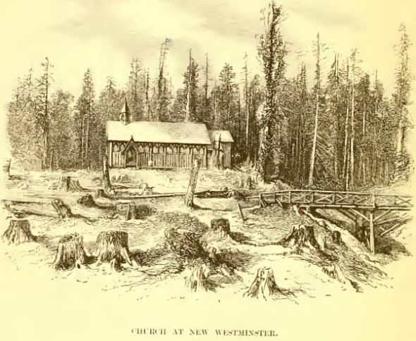
New Westminster, the present capital of British Columbia, the bank of
the river rises and forms an admirable position for the future town.
Mary Hill, upon which it is proposed some day to plant the citadel which
shall defend New Westminster, rises some three or four hundred feet; and
the camp, which lies at the distance of a mile east from the town
itself, stands upon rising land fifty to a hundred feet above the river.
As regards its position, therefore, there is no fault to be found with
New Westminster; but the forest is so dense, and the trees of which it
is composed so large, that its growth is likely for some years to be
very slow. Indeed, had it not been for Colonel Moody’s determination to
make a beginning, and for the labours of the Engineers in clearing the
site of their camp, New Westminster would have made little, if any
perceptible progress. As it is, if, as seems most probable, the tide of
colonization continues to flow northward, and a route to the mines
should be discovered up and from the head of one of the numerous inlets
north of the Fraser, New Westminster may never repay the labour that has
already been spent upon it. Of the severity of that labour, no one
unacquainted with the difficulty of clearing busli as it exists in
British Columbia can form any accurate conception. Felling the trees
forms but a small part of it. When they are down, they are, of course,
with the scanty resources at the settlers’ command, too large to be
removed, and they have to be sawn and cut up into blocks handy for
removal or burning. That done, the hardest work yet remains. In forests
such as these the roots of the giant trees have been spreading
underground for ages, forming a close and perfect network some eight or
ten feet beneath the surface. To dig this mass of interlaced roots up
would defy the strength and patience of ordinary men; and it is only the
wonderful dexterity of the Canadian —and, indeed, of the American
generally—in handling his axe, that enables him to enter upon, far less
accomplish, so difficult a task. Their dexterity is indeed remarkable. I
have seen three men—one of whom, by the way, had lost his right arm—fell
a tree four feet in diameter in three-quarters of an hour. This may at
first sight appear no very formidable feat; but, after a few days’trial,
the difficulties of such an undertaking will begin to loom upon the
amateur backwoodsman. I remember, upon one occasion, that an officer of
Marines quartered at Westminster, who thought himself, and who really
was, no contemptible axeman, underdertook for a wager to fell a certain
tree, some three feet in diameter, in a week. He made certain of
winning, and commenced work in the most sanguine spirits. But tlie end
of three days found his hands blistered painfully, and the tree upright
and almost uninjured as before. At the expiration of the stipulated time
another week was given him, and still the monarch of the wood held his
head erect. The story goes—this was, of course, after the bet was
lost—that he was found one night turning out some of his men to take a
sly chop at the tree after dark.
Despite all these drawbacks, however, New Westminster has an
unmistakeably thriving aspect. A church has been built, together with a
treasury and a court-house. Its streets boast also of two or three very
fair restaurants, some good wharves and stores, and several private
houses. In the camp, the Engineers, who for some time lived under
canvas, are all housed; and commanding a very beautiful view up the-
river stands a very comfortable house, the residence of their
commanding-officer, Colonel Moody. The view of the Fraser from the camp
is very pleasing. On the left, over Pitt Lake, rise the beautiful peaks
known as the Golden Ears ; to the right of these', the valley of the
Fraser can be traced almost as far as Fort Hope; while in the
foreground, looking over the buildings of the rising town, level land
stretches away into American territory beyond the boundary-line, as far
almost as Admiralty Inlet and Puget Sound.
Three miles below the town of Westminster, a fork of the Fraser,
unnavigable except for canoes and boats of light draught, diverges from
the main channel and meets the sea some 6 or 7 miles above the main
entrance of the river; and about the same distance above the town the
Pitt River flows into the Fraser. This river runs from a lake of the
same name. Its banks are low, and a considerable quantity of good land
well adapted for agricultural purposes lies on either side. Above, some
15 miles from Westminster,
Langley is reached. Here the steamers from Victoria are stopped by the
shallowness of the river, and their cargoes, human and material,
transferred to the stern-wheel steamers, boats, and canoes which from
this point do battle with the swift, uncertain stream.
Stern-wheel steamers are peculiarly American. They are propelled by a
large wheel protruding beyond the stern, the rudders—for there are
generally two or three—being placed between it and the vessel’s stern.
They are admirably adapted to pass between snags and close to bluffs,
where a side-wheel would be knocked away, and are affixed to
flat-bottomed vessels drawing no more than eighteen to twenty-four
inches of water.
American steamboat travelling has frequently been described, and its
peculiar characteristics and perils are doubtless' familiar to most of
my readers. There is something very exciting about it, certainly;
struggling up the river against the stream, the greatest risk comes from
the overcharged boilers giving way; but tearing down the current at some
twelve or fourteen knots an hour, bumping over shoals, striking against
snags, and shooting rapids, is 'far more animated work. Snags, which
form the most dangerous impediment to the navigation of rivers like the
Fraser, are, as may be known to most of my readers, large trees which,
having been carried down the steam to a shallow spot, become firmly
embedded there. As a rule, they float down the river heavy end first, so
that when they stick the upper part of the trunk opposes the stream and
is worn by it to a sharp point, in many cases sufficiently below the
surface to be hidden from the steersman’s eye.
Going up against the current, therefore, at a comparatively slow pace,
the steamer can afford to disregard the snags; for if she strikes on
one, it is easy to shut off the steam and drift back from it. But
spinning down the current, it is a very serious matter for one of these
large unwieldy boats to become transfixed upon a well-rooted, obstinate
snag. In some spots of the Fraser an awkward snag may equally impede the
navigation of a steamer up or down the stream. One, known as the
Umatilla Snag, from a steamer of that name having first struck upon it,
lies in a very narrow and rapid bend of the river, at which, from the
swiftness of the current, the steamer is very liable to be caught and
drifted back upon it, after, as she imagined, having safely passed it.
Upon one occasion, when I was going up the river in the ‘Enterprise,’ no
less than three times after we had struggled past the snag the strong
current caught and swung us broadside across the stream ; and it was
only by running the vessel’s bow into the muddy bank without a moment’s
hesitation, and holding her there by the nose, as it were, until she
recovered breath to make another effort, that we escaped impalement.
There was something very exciting in this struggle between the forces of
steam and water. Each time, as we hung by the bank, the engineer might
be heard below freshening his fires, and getting up as much steam as the
boilers could, or might not, bear for the next effort. The wheel-house
in these vessels is situated forward, so that there is almost direct
communication between it and the engine-room. By the helm stands the
captain. “Ho! Frank,” he hails down the tube, “how much steam have you?”
“So many pounds,” is Frank’s reply. “Guess you must give her ten pounds
more, or we shan’t get past that infernal snag.” And then more stoking
is heard below, and the unpleasant feeling comes over the listener that
the boilers lie just beneath his feet, and that, if anything should
happen to them, there can be no doubt about his fate. But, presently,
Frank’s voice sounds again. “All ready, Capten: can’t give her any
more!” The skipper loses no time; “Stand by, then!” is his response.
Then, to the men forward, who have made a rope fast to some stump on the
bank to keep the boat from dropping off, “Let go!” and she falls off for
a second or two; her bow cants out a little: “ting! ting! ting!” goes
the engine-room bell, the signal for full speed ahead; every timber of
the lightly-built vessel trembles. We watch the trees on the bank
eagerly to see if she moves ahead. Presently she drops a little, but her
head is still kept up; then the stream catches her on one bow. “Stand by
with the trip-pole!” is heard, and, as she swings round, “Trip!” is
shouted from the wheel-house. Into the swift shallow water the heavy
pole plunges, and perhaps she is brought up by it and run into the bank
again; or, as probably, if the bottom should be hard and rocky, or the
water deeper than was thought, away she flies down the river until she
is brought up against the bank or across the snag.
The perseverance of the
Yankee skipper in overcoming these difficulties is certainly remarkable.
Upon one occasion, after making four unsuccessful efforts to steam past
this “Umatilla Snag,” all the men had to be landed and track her past
the dangerous spot. So further up it was found necessary to resort to
the same tedious process, and the united strength of crew and passengers
with difficulty got her over a few hundred yards in the space of two
hours, “Frank” below in his engine-room cramming on all the steam he
could to help us. Nor is the composure with which the captain meets and
remedies an accident less remarkable. A supply of tarred blankets is
always kept handy for service, and if a hole is stove in the steamer’s
bottom, the captain coolly runs her ashore on the nearest convenient
shoal, jams as many blankets into the crevice as seem necessary, nails
down a few boards over them, and continues his journey composedly. He is
often reduced to very serious straits, no doubt, and is not at all
particular in the use of means to master a difficulty. I was assured by
a passenger in the ‘ Enterprise ’ to Hope in 1859, that he saw the
contents of a cask of bacon turned on to the fires when additional steam
to pass a troublesome rapid was necessary.
A little above Langley the Smess River discharges its contents into the
Fraser, and five or six miles onward it is fed by another stream of
similar dimensions, called the Chilway-hook, on the southern bank of
which are the remains of an old fishing-station of the Hudson Bay
Company, now unused. Both these rivers flow from lakes bearing their
names, and are in the summer-time, when swollen by the snow-freshets
from the mountains, deep enough for good-sized boats to navigate them,
but in the winter are almost impassable even for canoes. Three miles
above Chihvayhook River Fargo Bar is reached. This, the spot on the
Fraser where gold was first washed, has long since been deserted for the
richer diggings higher up the river. All along this part of the Fraser
the banks are low, and sandbanks occur constantly. In the winter the
channel is confined to one single swift stream, but in the summer-time,
when the waters are out, the navigator may well be bewildered by the
numerous channels which sweep over and between the banks and islands.
At a distance of 65 miles from the mouth of the Fraser the Harrison
River is reached, up which runs the Harrison-Lilloett route, which has
now become the principal road to the inland settlements. I have spoken
of the difficulties which lay in the way of making this route
practicable. A glance at the map will show that it consisted of a chain
of lakes, some a considerable distance apart, between which a way had to
be cut. The existence of this, route had been known to the officers of
the Hudson Bay Company for years; but no effort had been made to render
it available until 1858, when the rush of gold-seekers to the upper
country made the opening of some way such an absolute necessity that the
work was at once commenced. The scheme, which was by the time of my
visit nearly accomplished, was to go by steamer up the Harrison River
and Lake, a distance of about 45 miles, to Port Douglas, and from tliat
place to cut a road to Port Lilloett, a station at the south end of the
Lilloett Lake, and distant from Douglas some 32 miles. Along this part
of the route, or “portage,” as these trails are designated, over which
material has to be transported from one sheet of water to another, the
Lilloett River, which runs by or near it, is found of considerable use.
In the summer it is too rapid and dangerous even for canoe navigation ;
but in the winter-time, when the waters have subsided, the Indians make
their way up it, charging just one-third of the price required by the
land-packers. From Lilloett the lake carried them as far as Pemberton,
from which place another portage of some 22 miles brought them to the
south-west end of Lake Anderson, which is almost connected with Seton, a
lake of similar size, from the upper end of which the route to Lilloett,
upon the Fraser, is only three or four miles, and comparatively easy. By
this trail the dangers of the passage of the Fraser above Yale are
avoided, and a distance of some 120 miles of the most perilous
travelling saved. At the worst, when everything had to be carried from
one piece of water to the other by Indians, with immense labour and at
most extravagant rates of charge, it was far preferable to the river
route. And now that a broad waggon-road has been laid between Douglas
and Lilloett, which by the end of the year will be continued from
Pemberton and Anderson, the task of getting up to the mines from the
seacoast is rendered comparatively easy.
The main engineering difficulties in constructing the Harrison-Lilloett
route lay at its commencement. The Harrison River, which flows for about
five miles into the lake of the same name, is in one spot so shallow,
that the steamers, when the water is low, have to land their cargoes on
the bank, and boats inside the bar re-ship them for Port Douglas. Many
plans were suggested to obviate this difficulty. Among others it was
proposed to cut through the valley from the lake to the Fraser, thus
making no use of the Harrison River whatever. It was at last, however,
decided to make a canal through the flat, deepening it and walling it up
with large baulks of timber. This task gave Captain Grant and a party of
Engineers very moist occupation for two summers, and still I believe
baffles their labours.
Above the Harrison River the banks of the Fraser rise somewhat, and the
stream sweeps more swiftly between clay cliffs, from 10 to 30 feet high.
The navigation here becomes more and more difficult for steamers, and at
times, when the river is swollen by the snow-freshets from the hills,
they are altogether baffled. Between Hope and Yale they are at present
stopped by some rocks, which almost meet in the channel: were these
blasted away, steamers might reach the latter place; but at that point,
85 miles from its mouth, the river, tearing between high, in some cases
perpendicular banks, becomes impassable even for canoes. Steamers have
occasionally reached Yale, but it is seldom attempted, and still more
rarely accomplished.
Hope is perhaps the prettiest town on the Fraser. Indeed until Cayoosh,
or as it is now called Lilloett, is reached, there is no other
settlement that will bear comparison with it. Behind it Ogilvie Peak
rises abruptly to a height of 5000 feet: to the right stretches the
valley of the Que-que-alla, through which the trail to the new gold
districts in the Semilkameen country is cut; while in the front the
river glides, its channel divided by a beautiful little green island,
the hills upon its opposite bank rising gradually to a considerable
height, and forming a charming background to the prospect. High
expectations are entertained of Hope by its settlers; and indeed, since
the discovery of gold in Rock Creek and the Semilkameen Valley, for both
which districts Hope must serve as the emporium, there is a probability
that they may be, in some degree at least, realised, though at present,
all traffic being directed to Cariboo, it is not thriving.
Yale, 15 miles above Fort Hope, lies at the entrance of the Lower or
Little Canon, and is consequently the head of canoe or boat, as Hope is
of steam, navigation. As I have before said, the only obstacle presented
to steam-navigation between these two stations lies in some rocks, which
almost meet in the channel of the river off Strawberry Island, some six
or eight miles below Yale. There would be no great difficulty in
removing these, and I believe that at one time the Governor did invite
tenders for the work; but the scheme was wisely, and I should hope for
some time to come, if not finally, given up. The only benefit which
would accrue to the colony would be shifting at a great expense the head
of steam-navigation some 15 miles higher up the river, and thereby
supplying provisions to the bars between Yale and Lilloett a few cents
cheaper than at present.
There is nothing calling for any notice in Yale. It was selected by the
Hudson Bay Company as a convenient resting-place before commencing the
arduous ascent of the Canons, and where, having come down, they might
dry the furs and skins that had got wet in the passage. It is chiefly
useful now as a port for shipping and unloading materials from and to
the mines, and is besides enriched by the diggers from Hill’s and other
bars in its vicinity, who come hither on Sundays and holidays and spend
a great deal of their money. The site of the town is itself auriferous,
and all the front part of it has been washed.
At Yale my work in reality commenced, and several days were passed
discussing with those who were most likely to be well informed upon the
subject the best route I should take, and making preparations for it.
These were at last completed, and on the afternoon of the 2nd of May
we—that is, Mr. Campbell and myself, with a party of nine Indians—were
ready to start to ascend the banks of the Fraser to Lytton. While
talking the matter over, several highly cheering accounts of the perils
of the way had been volunteered by some officials, who had been there
recently collecting the licence-fees. They agreed in describing the
dangers of the Canons and Jackass Pass, through which our route lay, as
really great, and one of them, who had not been up, said quite seriously
that he should hesitate to undertake the journey for a thousand pounds.
These canons, of which there are two between Yale and Lytton, are narrow
passes, through which the river forces its way between steep, in some
cases perpendicular, banks, from three or four hundred to a thousand
feet high.
The journey between Yale and Lytton occupied five days; but as I
think'it scarcely possessed sufficient interest to carry the reader over
it step by step, it will be better perhaps to give him a general idea of
our mode of travelling and the country through which we passed. It had
been intended at Yale that I should be supplied with a white man who
knew the country, as interpreter; but upon its being proposed to him, he
declined to accompany me, having mining plans of his own, and I was
therefore obliged to be content with, an Indian who spoke French, not,
of course, of the purest. It is by no means uncommon to find natives in
the interior of the country possessing a useful knowledge of French. It
was the language spoken by far the larger number of the Canadian
voyageurs who first came across the mountains in the service of the
Hudson Bay Company, and indeed their trade at their inland posts is
mostly carried on in French.
An Indian has a great objection to travelling without a companion of his
own tribe, and consequently after Mr. Ogilvy. the Hudson Bay Company’s
officer at Fort Hope, had succeeded in obtaining for me the services of
Tom (by which name my interpreter was known), I found myself compelled
to engage a friend to accompany him. The inconvenience of this
arrangement was subsequently felt to be very great; for Tom falling ill
at Fort Kamloops, his friend, who by that time had become valuable to
us, persistently declined to leave him, although of course I in my turn
refused to pay him if he remained. A few words here as to our personal
equipment may be permitted. For trips such as these I always wore a
shooting-jacket with as many pockets as possible; strong corduroy
browsers, tied under the knee after the fashion of English navvies, to
take the drag off it when they are wet; and an old uniform cap, which I
always found had a capital effect upon Indians, inspiring them with an
idea of the wearer’s exalted position as a “Hyas Tyee,” or great chief.
Slung over my shoulder I carried an aneroid, which, with a spy-glass,
completed my equipment. Dr. Campbell carried the gun on this occasion,
as I had a chronometer in my pocket, which it was of the greatest
importance not to disturb, and I therefore did not shoot. My spare
things, packed in a small valise, consisted of a clean flannel shirt,
six or eight pairs of socks, a Hudson’s Bay capot (a sort of blue
frock-coat, made with a hood to it)—upon the cuffs of which a
lieutenant’s gold lace was put to add to the effect, and which was worn
before the natives upon all particularly important occasions—and a coat
and trousers made of blue blanket, which I put on as soon as we camped
at night, and in which I always slept. As to provisions, all we ever
carried was a side or two of bacon, four or five bags of flour—the
quantity depending upon the time that was likely to elapse before fresh
stores could be reached—plenty of tea and coffee, and a bottle of brandy
in case of accidents. Our fare upon occasions like this consisted almost
exclusively of bacon and dampers, with tea and coffee. Now and then we
might be lucky enough to shoot a grouse; but this happened rarely, as
when you are travelling with an object, time cannot be given to going
out of the way to hunt up game. Dampers, although well known to
colonists in new countries, are, I may explain for the benefit of my
English readers, cakes of dough rolled out to the size of a plate, and
one or two inches thick. They are cooked either by being baked in the
wood-ashes of the fire, or fried in the pan with bacon fat.
Besides the things already enumerated, I had to carry a sextant and an
artificial horizon for getting observations for latitude and longitude.
Upon these things being packed, they were found to amount to so
considerable a weight and bulk, that nine Indians were required to carry
them. These were engaged at two dollars (or 8s. 4d.) a-day, which, with
their food, was the lowest price at which the Indians would work in
those parts. The things were then divided into bundles or packs, as they
are called, of as even weight as possible, giving some 50 or 60 lbs. to
each man. Arranging these packs is a matter of no little difficulty, for
the Indian has a great objection to altering his load after he has once
started, so that you have to give the men carrying the provisions, which
grow lighter daily, a heavier load at starting than those who have the
canteen or the tent to carry. The majority of these Indian porters have
now adopted the dress of Europeans, and turn out for the journey in
trowsers and sin usually carrying an old coat of some sort, which they
are careful to put on upon nearing a town. I have known them to be
absurdly particular about this ceremony. I once journeyed with
half-a-dozen Indians, each one of whom positively carried a suit of
clothes in a bundle on his back for more than three weeks, to have the
gratification of wearing them at Port Douglas. When we were within a
mile or so of the place the party halted, untied their bundles, donned
their clothes, and painting their faces bright red, filed into the town
with dignified gravity. Shoes are the one article of European attire
which they do not take kindly to wearing, although they always ask for a
pair at starting, which, too, they carry in the pack upon their backs.
They either travel barefoot or in mocassins, which are not the pretty
things embroidered with beads which one sees in pictures, but a plain
piece of deerskin, laced round the foot with a strip of the same
material. I have known occasions when an elk has been killed by me, and
within a quarter of an hour after its death all the meat has been slung
at their backs and its skin been laced upon their feet.
Previous to beginning a journey with Indians, they always look for a
present. Indeed it would be difficult, if not impossible, to get them to
start without this ceremony being gone through. It is not a very serious
tax, all that is expected being that you should give them a
“cultus-patalatch” (literally, a useless present). Tobacco is often
selected for this purpose, and it is generally advisable, if their
squaws are present, to remember them, as this will do more than anything
else towards starting them. The Indians, too, are always pleased at
having a clay pipe given to each on starting, even if it is never used.
Smoking, by the way, has a curious effect upon them. As a rule, although
they soon learn to smoke as we do, they begin by inhaling it, swallowing
enough in a few minutes thoroughly to intoxicate them. I have seen one
pipe passed from one to the other of the party suffice to bring them all
into this condition. The effect does not last long, and in a quarter of
an hour they wake up from their drunken dose, looking and no doubt
feeling very much the worse for it.
The daily routine of life upon the march varies little. About five in
the morning we rose and got under way as quickly as possible. I used to
indulge in a cup of coffee before starting, but experience soon taught
me that it was better to make only two good meals a-day; between ten
o’clock and noon, therefore, we halted for breakfast. For this meal we
only unloaded what was absolutely necessary, and did not pitch the tent.
A likely spot was selected near a stream and if possible under some
shady trees, a fire was lit, and the cooks were soon busy kneading the
dampers and boiling the tea. While this was going on—for after the first
day we were glad to leave the cooking with the Indians—I used to get out
my sextant to be ready for the meridian altitude of the sun at noon,
and, if our halt were sufficiently early, get a set of a.m. sights
first. By the time I had done this, breakfast was ready, and our
appetites being freshened with a six hours’ walk, dampers of the
consistency of saddle-leather disappeared as if they had been
puff-paste. After breakfast we would start again, holding on steadily
until evening, when the most convenient camping-place was selected for
the night’s rest. The Indians in walking are accustomed to stop for some
five minutes’ rest every half-hour, and this they do with surprising
regularity. They generally squat down near a ledge of rock, on which
they can rest their burdens without removing them. They carry everything
in the same way, viz., with a band over the forehead, the pack resting
on their shoulder-blades, or a little below.
When a halt was called for the night, the Indians divided the labours of
camping. The cook, who was sometimes the same throughout the journey,
collected small wood, and made the fire; upon his way he had very likely
picked up pieces of charred wood, to assist him in this operation;
another cut larger logs, for use during the night; the head man pitched
our tent, while another gathered a quantity of fir-boughs, on which we
should sleep ; others fetched water; and if any deer-tracks had been
seen, or it was thought game might be found in the neighbourhood, one
took a musket, and went in search of it, generally, I must say, with
little success. As a rule, Indians make very bad shots. They never think
of shooting a bird on the wing, and only bring down deer by hiding near
a river, to which they know the animals will come at nightfall to water.
When these preparations have been effected, and while the dampers are
cooking, the Indians are, perhaps, making themselves drunk upon tobacco,
which does not, however, at all affect their appetite, or are busy
making spoons for their repast. It is not at all uncommon for them, if
they have leisure, to spend it in making a set of bark spoons for
supper. This they do in a very ingenious manner, cutting a strip of bark
some three or four inches, and splitting it half-way down; then bending
back the slit portion at right angles to the other, and tying them with
fibres of the same material. It is an operation that must be seen to be
thoroughly understood, but they do it with considerable dexterity, and
the task of allotting the spoons when made among the party, according to
the size of each mouth, leads to very great merriment. Stolid as Indians
appear in their villages, upon a cruise of this sort I have always found
them in high spirits, and they would discuss the adventures and mishaps
of the day’s journey with great animation, frequently referring to me to
settle any vexed question that might arise. They are very quick, too, at
noticing any breach of their own code of manners, and are unsparing in
their raillery of the offender. Gluttony particularly excites their
ridicule. I remember on one occasion an individual of my party happened
to be a great eater, and the others scarcely gave him any rest whatever,
explaining to me that he deserved it, being “carqua cushon” (like a
pig). Another of their comrades happened to be a very good-looking
fellow, and, although I believe he was secretly respected for it, he had
to endure a great deal of raillery upon his reported successes with the
fair sex. Indians appreciate nothing more highly than physical prowess ;
and a good warrior or hunter needs no other recommendation to be admired
and envied — the words are synonymous there as elsewhere—by both the men
and women of his tribe; and these qualities my friend the lady-killer
possessed in such a marked degree, as to make his companions’ raillery
so subdued in its tone as to be almost flattering. In travelling with
Indians, should the Englishman be anything of a sportsman, he will find
it easy to secure the respect of his guides and packers. Shooting a bird
or two on the wing, or bringing down a deer running, will raise him high
in their estimation; and he may secure it beyond a doubt by walking them
well off' their legs on the first day’s journey. They will not bear him
the least ill-will, and they respect him ever after.
Now that I am on the subject of Indian manners, I may mention a strange
vanity of their young men who aim at gaining reputation as great hunters
or warriors. This is their fashion of scoring their legs, under the
impression that it gives them strength and endurance, and renders them
impervious to cold. The limb is deeply cut in circular fashion, from the
hip to the knee, making it look not unlike fish crimped for cooking.
These indentations are very deep, and can, of course, only be made
gradually, one wound having to heal before another is inflicted, so that
a man is generally twenty-five or twenty-six years old before the
process is completed. Some such fashion is not uncommon among other
savage tribes. The natives of Moreton Bay, in Queensland, for instance,
are in the habit of cutting their bodies deeply round from the shoulder
to the waist, filling up the gash with dirt, so that, when it heals, the
scar projects like a large rope or wheal tied round their bodies.
I have strayed, however, from our camp-fire, although not so far,
perhaps, as our thoughts wander sitting by it, with night closing in.
While the Indians laugh and talk, or busy themselves mending their
garments and patching their mocassins, turning and twisting them about
in every direction to find a sound part to serve as a sole to protect
the foot for the next day’s journey over the rocky trails, a pipe is
smoked, the notes of the day discussed and transferred to the
field-book, to-morrow’s work talked over, and then to bed— my companion
and myself in the tent, the Indians grouped about the fire. I have said
that I always slept in a blanket suit, and I recommend this precaution
to travellers emphatically. However hot the day may have been, the night
in British Columbia, even in the months of summer, is always fresh and
cold. Cold as it may be, however, the Indian invariably strips to sleep,
and lies with his blanket wrapped about him, feet in towards the fire.
Even when camped in snow, I have observed they always take off then*
clothes.
Fort Yale is situated on the left bank of the Eraser, at the entrance to
the Little Canon. The banks of the canon are so perpendicular that the
traveller is obliged to leave the river’s side to pass it, unless the
water is very low indeed, when there is a narrow trail at the bottom of
the cliff. The trail commonly used, and which is now made into what
would be a very fair mule-road, save for the snow, which blocks it up
for seven or eight months of every year, leads, up a considerable
height, and through a gorge between two mountains, coming down on the
river again between the two canons, about five or six miles above Yale.
As we did not start until after noon, it took us till camping-time to
pass the canon, and we pitched our first camp w7hen we came again upon
the river. Next day we passed the Upper, or High Canon, which is six or
eight miles long. Before entering we had a magnificent view up it, and
very striking and wonderful it was.
These canons, pronounced by all the miners canyons, are narrow passes,
where the steep, almost perpendicular mountains, close in upon the
stream. Overhead the rocks near each other, in some places almost
meeting; so that from below a mere irregular thread of light is seen.
The surface of the river is uneven, and the fall so great, that here and
there cascades are formed, over which the stream rolls with fearful
rapidity. In the summer time it sometimes tears along at the rate of 20
miles an hour, and when I was there it was flowing 15 or 16, as I
ascertained by experiment. In winter, when the stream is at its lowest,
they are navigable for canoes and boats, but this is always attended
with considerable danger, and many lives have been lost in them. Miners,
however, dare anything; and when Governor Douglas was at Fort Yale, in
1850, he saw a man who had actually come down through the canons lashed
on to a large log of timber!
As I have said, the view before entering the Upper Canon is grand.
Looking up between the precipitous cliffs, the 'water is seen rushing
through them at fearful speed. I hardly know which was more grand, the
view from this spot or that further on, as we got well into the canon,
in which in some places the trail led up crags so steep that we had to
clamber up them with our hands and feet, until we arrived breathless at
the top of a projecting ledge, on which we -vTere glad to halt a few
minutes, to draw breath and gaze with wonder on the scene. Before and
behind, peak after peak rose 1000 or more feet above us, although we
were probably 600 or 800 feet above the river, each more rugged, bold,
and grand than the other; while beneath, the river, white with foam,
whirled along, gurgling and eddying, its wild reverberations continued
in endless echoes. Grand as the scene was, watching it, my brain grew
dizzy, and I was glad to turn away and continue my journey, fearful
lest, if I looked longer, that strange desire which creeps over you to
spring into the boiling torrent should become too strong for further
resistance. At the present day the trail— which is the name given in the
country for any sort of path—is so improved that I believe mules travel
by it without difficulty when the snow is not on the ground. I should be
very sorry, therefore, to say anything disheartening to the intending
settler, although I may add that anyone who would be discouraged by
difficulties such as these had better not visit British Columbia. At the
time I speak of there were three trails, though they were not entirely
separate. The first of these, the Mule-trail, was completely blocked up
by snow; it is hardly ever open till June. The others were known as the
“Lower” and “Upper” Canon trails. The lower trail could only be passed
when the water was low, at which time there is a ledge of boulders along
the bottom of the cliff, over which a rough path was carried. The upper
trail passed along from ledge to ledge, at a height ranging from 50 to
800 feet above the river. We went partly along each of these trails.
When we could we kept the lower, but constantly, on coming to some bluff
of rock jutting out into the river, we had to scramble up into the upper
trail to pass it. The mode of rounding these cliffs, which literally
overhang the river, is peculiar, and makes one’s nerves twitch a little
at first. There are two or three of them, the trail coming up to them on
one side, and continuing again on the other. The difficulty, of course,
was to pass the intervening space. This was managed by the Indians thus:
they suspended three poles by native rope, made of deer-hide and fibre,
from the top of the cliff, the inner end of the first and third resting
on the trail, and the middle one crossing them on the front of the
bluff. Of course there was nothing to lay hold of, and the only way was
for the traveller to stretch out his arms and clasp the rock as much as
possible, keeping his face close against it; if he got dizzy, or made a
false step, the pole would, of course, swing away, and he would topple
over into the torrent, which rolled hundreds of feet beneath. The
land-slips in the mountain crevices are also very dangerous. Several
times we had to make an ascent of about 200 feet up a land-slip, at an
angle of quite 35°, in loose sand, and with nothing to check our
downward progress if the sand should slip quicker than we could scramble
over. The most dangerous of these, which we did not pass till the third
day, but which I may as well mention while upon the subject, is called
the Jackass Mountain. Several people have lost their lives in crossing
this, and on one occasion a mule, which some miners tried to get across
it, was, I believe, with his driver, precipitated into the river; which
circumstance may, perhaps, account for the name of the mountain.
This mountain rises abruptly out of the river, and the old trail leads
across the face of it. To pass it several land-slips, of twenty or
thirty yards wide, and at an angle of about 50°, had to be crossed. To
do this the traveller had to make a bolt from the rocky ledge on one
side to that on the other; and if he chanced to get dizzy, or the land
slipped away with him, he must inevitably be lost. My companion had here
a most merciful escape. He got dizzy, and slipped, but had got so far
across that he was just able to grasp a root above his head, and thus
save his life. I had just crossed, and was watching him, when I saw him
turn pale and slip. It was all the work of a second, however, and before
I could move he was hanging on to the root.
The following extract from the Journal of the Bishop of Columbia, when
travelling over the same ground, will prove that my description is not
exaggerated:—“We continued the ascent for some distance. Impassable,
indeed, much of it was for horses and mules, and even for man not
without danger. We must have been at the height of 2500 or 3000 feet;
our pathway lay along the edge of a perpendicular fall of such a height,
sometimes along beds of loose rock, and most warily must the feet step
from stone to stone; a slip would either precipitate to the abyss below,
or cast you among the rocks, where a limb might easily be broken. At
other times in the descent the path was nil, the projections for the
foot not an inch ; it seemed like the crawling of a fly upon the
perpendicular wall. This sort of work lasted for hours. It was, however,
so absorbing, and required the utmost constant stretch of attention for
self-preservation, that the time passed more rapidly than one would have
thought. At the time the critical character of this operation was such
that, though near together, no one spoke; there was a solemnity, as if
we realised hanging between life and death. Frequently we had to crawl
upon hands and knees. It was quite wonderful to see the Indians, with
then- heavy loads, pass along; one of ours did fall, however, once. We
came occasionally to mountain torrents, bringing down the cool water
from the snowy height. At one time we slaked our thirst from the snow
itself. At length we had gone over the worst of the Lake Mountain; the
Fraser was again spread out before us; the smoke in the distance pointed
out the dwellings upon Boston Bar.”
Fifteen miles above Yale is Spuzzum, an Indian village, where there is a
ferry, and here the mule-trail leads across to the east bank of the
river, which from this point runs nearly north and south. The foot
trail, the best in winter, keeps along the west bank to Island Bar,
which is opposite to Boston Bar, and forty miles above Yale. Boston Bar
is at the mouth of the Anderson or Coquibme River, and it is to this Bar
that the people of Fort Hope wish to have a direct road made, which, I
believe, has since been begun, cutting off the small elbow which the
river makes, and avoiding Yale and the canons altogether. This will very
likely become a valuable route for the Lytton and Thompson River
country, but not for that which is attracting the greatest notice now—
viz. the Cariboo. The Anderson River is a considerable one, and, after
running in a short distance, it divides into two branches, one trending
northward till it nearly meets one of the tributaries of Nicola River,
and the other running southward and almost joining the north branch of
the Que-que-alla coming up from Hope. It is along the banks of these
streams that the Hope and Boston Bar trail passes.
At Boston Bar the Fraser Valley opens out a little, and between it and
Lytton several flats occur, which will some day, no doubt, be converted
into pretty little farms. The largest of these, which is five miles
above Boston Bar, was already fenced in when I was there, and had a hut
built on it. These flats, or benches as they are called in this country,
are found generally at the bends of the river, and are raised some fifty
or sixty feet above it. They occur much more frequently on the Thompson
and Nicola Rivers, and higher up the Fraser, than here. They are all
covered with the long sweet grass of which cattle and horses are so
fond, and which has so wonderful an effect in fattening them. I have
seen horses on Vancouver Island, where the same grass grows, which have
been turned out in the autumn, brought in in April in splendid
condition, and as fresh as if they had been most carefully treated all
the time. This is, indeed, the common custom with the island horses, and
I remember one of the oldest and best farmers there saying that the only
horses he had ever lost were killed by being-taken too much care of, and
kept in all the winter. Jackass Mountain is ten or twelve miles above
Boston Bar, and when it was crossed all dangers were past, and we
trudged on easily, reaching Lytton two days after we passed Boston Bar,
and five days from the time we left Yale.
The whole way from Yale to Lytton, which is 60 miles, the geological
formation of the country is the same, and we passed between steep
trappean and granitic mountains 2000 to 3000 feet high, the distance
across the river from peak to peak not averaging more than a mile. There
is very little land fit for cultivation, except, as I have said, on some
of those benches which are found on all the rivers of this country, and
which point out the higher level their streams once occupied, and the
subsequent upheaval of the whole country.
Lytton, at the time I saw it, consisted of an irregular row of some
dozen wooden huts, a drinking saloon, an express office, a large
court-house—as yet unfinished—and two little buildings near the river,
which had once belonged to the Hudson Bay Company, but which were now
inhabited by the district magistrate. This gentleman happened to be
absent from Lytton, but I found his constable, and at once took up my
quarters in the courthouse. Next day, thinking we should find it
preferable, we pitched our tent without; but the clouds of dust which
swept over Lytton continuously soon made us glad to seek its shelter
again.
Whilst here I determined, instead of making our way direct to Lilloett,
to diverge by the way of the Nicola River and Lake to Fort Kamloops or
Thompson, situate some 90 miles up the Thompson River. Seven of our
Indian escort, when they heard of my purpose, refused to accompany us to
Kamloops, unless I would promise them to return from that place direct
—a programme I had no intention of following. Tom and his friend,
however, stuck to us; and I found an Indian who owned two horses, and
who undertook the transport of our packages, by this time, of course,
considerably reduced in weight and bulk. As it proved, we were most
fortunate in this arrangement, for without horses we should have found
it impossible to ford the Nicola, and must inevitably have been turned
back on reaching that river. Pleased enough to leave the dust and wind
of Lytton, our little party started for Kamloops. |