|
Tourism in Peace River
Peace River District, Canada
Its Resources and Opportunities

By F. H. KITTO, D.L.S., A.M. CAN. SOC. C.E.
Prepared under the direction of the Superintendent
Natural Resources Intelligence Branch.
In the preparation of this report valuable assistance has
been received from officials of the Federal Departments. Mr. Charles
Camsel of the Geological Survey of Canada and Mr. C. H. Attwood of the
Dominion Water Power Branch have prepared the chapters dealing with
Mineral Deposits and Water Powers respectively. The Director of
Experimental Farms, The Director of Forestry and the Commissioner of
Dominion Parks have revised those portions of the report relating to
their work. The assistance rendered by these and other authorities is
gratefully acknowledged.
Department of the Interior Canada
THE PEACE RIVER DISTRICT
The Peace River District of Canada has been for many
years the subject of much interest and speculation. Alluring tales from
adventurous pioneers of its wonderful resources, its charming climate
and varying scenery, had long since lent to the district that charm of
romance which distance and uncertainty blend with glowing promises. Now
the land so long famed by legend and mystery is being proved a reality.
Modern transportation has brought the district to our doors, and our
keen searching trials and tests are proving it to be all and more than
it was represented to be. The tales were not myths; the truth was not
half told, and every day added treasures of the district are being
unfolded to our eyes.
This district, the drainage basin of the Peace river,
lies in the northern parts of the provinces of Alberta and British
Columbia. It extends approximately from latitude 54° to 59° north and
from longitude 112° to 125° east, and is a part of the great Mackenzie
River drainage basin. Falling away from the Rocky mountains, it embraces
a part of their eastern slope, and sweeps eastward and northward over a
huge plateau extending to Lake Athabaska and the Athabaska and Slave
rivers.
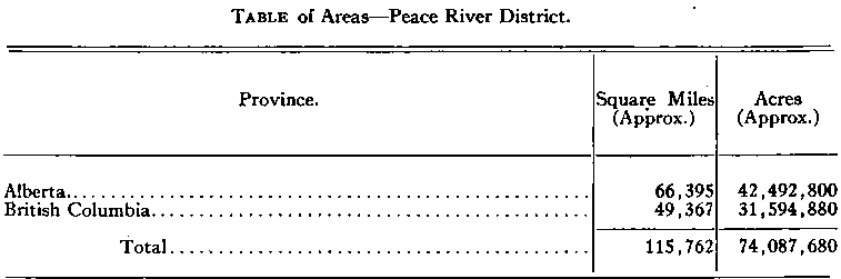
The area of the Peace River drainage basin is over one
hundred and fifteen thousand square miles, as shown in the following
table:—
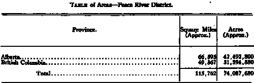
Of this vast area, the greater part falling within the
province of Alberta, especially the territory lying immediately to
either side of Peace river, is proving suitable agricultural land,
either for mixed farming or ranching. To this must be added a block of
three and a half million acres known as “ The Peace River Block,” lying
within the province of British Columbia and adjacent to Alberta. The
balance of the British Columbia area, while containing much valuable
agricultural land in various valleys, is principally a mountainous
region. With those portions of the Alberta area lying at the headwaters
of the various tributaries of the main river it forms a vast area of
mineral and timber resources, the extent of which is only beginning to
be realized.
The Peace River
The Peace river itself, beautiful and majestic, has its
origin in these eastern slopes of the Rockies of northern British
Columbia. It flows through mountain canyons and broad prairies for some
eight hundred miles till its waters are joined by those of the mighty
Athabaska, to sweep northward to Great Slave lake. This huge lake, a
veritable inland ocean, feeds the Great Mackenzie river, which flows
northward a thousand miles and drains an area of over half a million
square miles.
Two large mountain rivers, the Finlay and the Parsnip,
the one flowing southerly, the other northerly, unite their waters at
Finlay Forks at the foot of mount Selwyn, towering 3,000 feet above
them, and the larger river thus formed by their confluence is known as
the “Peace.” From this inspiring source, with an initial width of 300
feet, the Peace runs in an easterly direction through the mountains and
foothills to burst forth at Hudson Hope, on the upper limit of the Peace
River block, into the vast plateaus it drains.
Below Hudson Hope it widens out and flows with a uniform
current through a valley cut deep across the surrounding plains. Fort
St. John, British Columbia, is on its left limit in the Peace River
block. Dunvegan is also on its left bank, in Alberta, and here is
located a ferry where the old wagon road from Edmonton crossed to
continue to lake Saskatoon. Finlay Forks, Hudson Hope, Fort St. John,
and Dunvegan are still practically trading posts, but little changed
from early days. But sixty miles farther downstream, the old “Peace
River Landing,” or “Peace River Crossing,” has given way to the new
thriving town of Peace River, now linked with steel to Edmonton and the
“outside".
This point on the river was formerly reached from
Edmonton by a two or three weeks' trying stage journey over a trail that
spelt discomfort and hardship at every turn, whereas now one can travel
by rail with all the comforts of dining and sleeping cars in twenty-six
hours over practically the same route. From here modern steamboats ply
up and down the river, a ferry crosses it, and a giant steel bridge is
now being built to span it, to allow the rails to push farther west and
north.
From “The Crossing,” as this town is locally known, the
river's course is almost due north some two hundred and fifty miles to
the old historic trading post of Fort Vermilion, where another ferry has
recently been provided; thence easterly again to the rapids and falls of
Vermilion chutes. Navigation is here interrupted again. Below the chutes
the river winds northeasterly till it is joined near the northwest end
of lake Athabaska by the waters of this lake and the Athabaska river.
From the confluence of these great waters the large river formed takes a
new name, the “Slave,” and the Peace loses its identity in the union.
The Slave flows northerly to Slave lake, broken once by a series of
rapids from Fitzgerald to Fort Smith, on the northerly boundary of
Alberta.
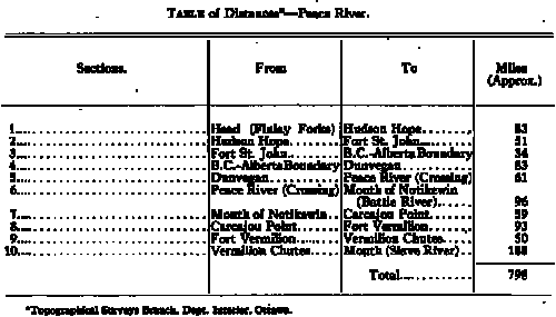
It will be seen that the Peace is divided into three
great sections. Above Hudson Hope it is navigable from the head of Rocky
Mountain Canyon to Finlay Forks. Navigation also extends ninety miles
additional up the Finlay and some distance up the Parsnip. From Hudson
Hope to Vermilion chutes large steamers ply regularly during the open
season. Below the chutes the river is navigable to its mouth, from where
navigation extends down the Slave as far as Fitzgerald, also on lake
Athabaska and up the Athabaska river as far as Fort McMurray.
As shown in the following table, the Peace itself is some
eight hundred miles in length. It varies in width from three hundred
feet at its head to a mile and a half at the chutes.
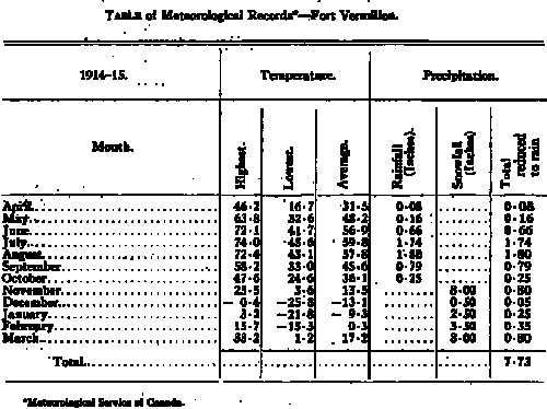
Climate
The climate of the Peace River District is excellent, and
remarkably moder ate considering the latitude. The air is pure and
bracing: in winter clear and crisp, and in summer dry and balmy.
Extremes of temperature, sudden changes, and severe storms are very
rare. The winters are by no means mild, but are very dry, with clear
skies, little snowfall, and few winds. Blizzards are unknown, but the
mild Chinook winds occasionally sweep through the mountain passes from
the warm Pacific, giving pleasing respites of balmy days to break the
monotony of a steady cold. Spring comes early and quickly; the snow soon
disappears, and the ground is dry in a few days. Ice on the lakes and
rivers breaks up during the latter part of April or early in May.
Seeding usually begins, early in April, sometimes in March, and at Fort
Vermilion about the first of May. Most of the rainfall occurs in June
and July. The average precipitation for the full year is about twelve or
thirteen inches.
The summers are remarkable for their long days and short
nights. For three months there is almost continual light, the nights
being merely a couple of hours semi-darkness, except when the sky is
overcast. The days are warm, but the heat is not sultry or murky. The
nights are cool and conducive to rest. Summer frosts, hail-storms, or
fierce winds are very rare. These are the growing days when vegetation
makes its remarkable progress to compensate for a short season. The
long, cool evenings are especially pleasing after the day’s heat.
Harvest commences about the middie of August. September
is an especially pleasant month. The days are still warm, but the nights
grow colder and the flies disappear. Life in the woods is at its best
during this month. October brings heavier frosts, and the ice forms late
in this month or early in November. Winter can usually be expected early
in November, though mild weather until Christmas is not uncommon.
The rigours of the climate need not be feared, but houses
should be substantially built to withstand the cold spells. Warmly clad,
a person enjoys the out-of-door life at any time during the winter.
Taken the year round, the climate is healthy and pleasant, and conducive
to active and vigorous outdoor life. .
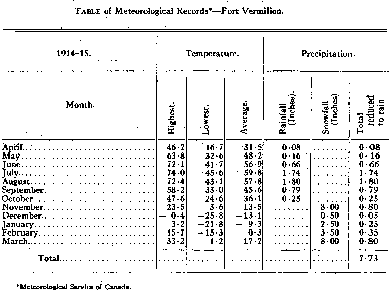
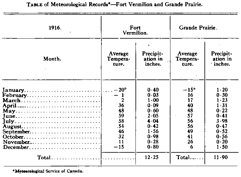
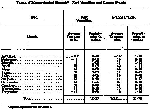
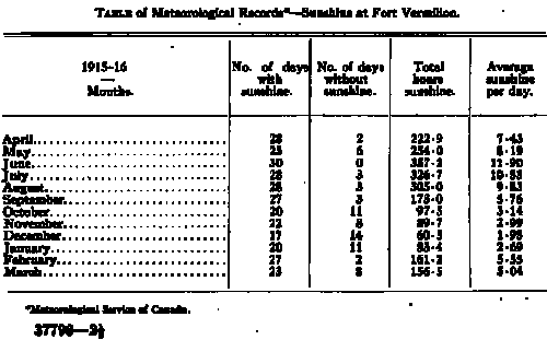
The following tables, taken from official meteorological
records, give some interesting information obtained at different points
throughout the district:—
Soil
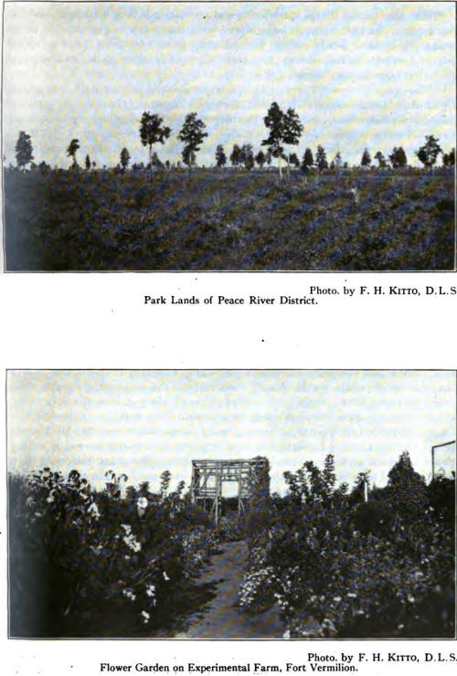
The soil of the greater part of the district is
especially suitable to the growing of grains, grasses, and vegetables.
The valleys of the upper sections are very rich in river silt and black
and sandy clay loams. Clay, sandy clay, and black loam, with a subsoil
of the same, are the prevailing soils of the entire district. Occasional
sand ridges, usually covered with jack pine, are found, but these
comprise a very small percentage of the area. Some good land is covered
with light muskeg or is marshy, but much of this can be easily drained.
The usual run of soil is free from alkali, and well adapted to growing
wheat. The district, generally speaking, is level or slightly rolling.
Very little gravelly land occurs, and field stones and
small boulders are found only in restricted areas, and even there in
small numbers. Generally speaking, the entire district is exceedingly
fertile, the percentage of barren land being practically nothing. The
district is well watered by numerous rivers and streams of pure water.
Where homesteads have no stream, good water is obtained by digging or
boring wells. The Fort Vermilion district is especially favoured in this
respect, water being found at depths from 18 to 40 feet. In other
districts it is sometimes necessary to go as deep as 60 feet, but
failure to get water at this depth is unknown. Good flows are usually
found at 20 to 30 feet.
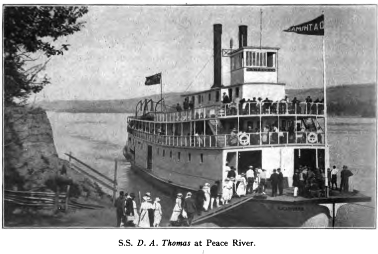
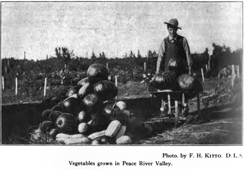
Richly productive and easy to till, the soil of this
district is inviting to the farmer and gardener. Bountiful yields, with
a minimum of labour, tend to encourage the increase of production and
maintain the quality of produce.
The lover of flowers or kitchen gardens is richly repaid
for a few minutes spent in planting and caring for the house garden.
Flowers and vegetables grow with a wonderful energy, and spread cheer
and profit alike.
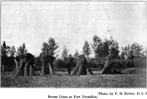
Timber
Much has been written about the vast prairies and lightly
wooded sections of the Peace River District. While these are extensive,
the greater portion of the district, taking into account the mountain
slopes and deep valleys of its outer bound, is thickly wooded with
valuable timber. The principal varieties include fir in the mountains,
spruce, pine, tamarack, birch, poplar, cottonwood,

and willow. The upper reaches of the district, including
the mountains and foothills, are especially well wooded, but timber of
good dimension is found in all the valleys throughout the entire
district. Many large islands occur at intervals along the Peace, and
these are all thickly wooded with fine straight spruce. Valuable timber
limits on the Wapiti are yet untouched. The North and South Pine rivers,
the Smoky, the Whitemud, and the Notikewin (Battle) are well wooded;
while farther east and north the Wabiskaw contains millions of feet of
untouched timber. At Fort Vermilion there are three saw-mills, with
planing and shingle machines, and all building material required there
is cut and manufactured locally. Peace River is well supplied with
mills, and others are being installed throughout the district as
required.
With the continued settlement and opening up of the
district, the lumbering industry will assume greater proportions. While
the hard woods and more valuable specimens of softer woods are not
generally found, the wealth of the forests is still very great. Spruce
is extensively used for lumber. Other woods yield logs for building,
fencing material, ties, mine timbers, and fuel. Much pulpwood is
available. Extensive forests of beautiful white poplar also exist.
Except on the open prairies, a sufficient supply of timber is found to
meet all the requirements of the settler for many years.
Mineral Deposits
By Charles Camsell, B. Sc.
Geological Survey of Canada.
Prospecting for mineral deposits in the basin of Peace
river has nowhere been of an intensive character, and by far the greater
portion of the basin has never been visited by the prospector. Both
metallic and non-metallic deposits are, however, known to occur in
considerable quantities, the former in the region west of the Rocky
mountains, namely, in the basins of Finlay and Omineca rivers, and the
latter in the eastern slope of the Rockies and the region to the east of
them.
The great rush of placer miners into the Caribou gold
fields in. 1860 led to the discovery of gold on the Parsnip river in
1861, and in the following year on the Finlay. Soon after this the
famous Omineca fields were discovered, which, in their history, have
yielded about one million dollars’ worth of gold. The easy rich diggings
of this field were, however, exhausted in a few years, and the miners
gradually pushed their way down stream, working bars on the Peace and
its tributaries wherever they found pay rich enough to stand the high
cost of mining. Bars were worked as far down as Hudson Hope and even to
the mouth of Battle river, but the gold was found to become finer as
distance from the mountains increased. Very fine gold has been carried
as far down stream as Fort Vermilion, but the difficulty of recovering
this is too great to make it worth while mining. Placer mining is still
being carried on in the upper waters of the Peace river, but the total
production is comparatively small, and until transportation is provided
that will alloitf the large-scale operations of dredging or
hydraulicking to be carried on, a larger yield is not to be expected.
Gold quartz veins occur at mount Selwyn and on Omineca
river, and large veins of silver-bearing galena have been known for many
years near Manson. No actual lode mining has, however, yet been
undertaken.
Seams of coal are exposed in Rocky Mountain Canyon above
Hudson Hope, and, though only two to three feet in thickness, are of
excellent quality and higher grade than most of the Western Canadian
coals. Coal measures also outcrop to the south on Pine river, and on the
headwaters of Smoky river, and contain coals which have been classed as
bituminous and, in one or two of the seams, as anthracite. The possible
area of these fields, therefore, is large,' and the quality of the coals
indicate that this is one of the most important coal fields of Western
Canada. Lower grade coal has been found lower down Peace river at the
town of Peace River and on Red Willow river.
Springs of natural gas and tar rising to the surface at
several points in the valley of Peace river suggest that reservoirs of
both these substances exist at depth in the rocks below. Drilling has
been undertaken at two or three points to tap these reservoirs, and in a
well near Peace river a heavy flow of gas was struck, at a little over
1,000 feet in depth. Some heavy oil was also obtained which, by pumping,
would amount to a few barrels daily.
Beds of gypsum, ten to fifty feet in thickness, are
exposed on both banks of Peace river near Peace point for a distance of
15 miles, and it has been estimated that there are over 217,000,000 tons
of this material adjacent to the river, much of it very favourably
situated for mining. Salt is associated with the gypsum in the country
north of Peace point, and some hopes have been entertained for the
finding of potash in association with the salt and gypsum, as it is in
certain parts of the world.
While all the mineral deposits of the Peace River
District are still in an undeveloped state, it has been fairly
satisfactorily proved that there is a large amount of coal, gas, and
gypsum, and the settlers of that district can be assured of an adequate
supply of coal and gas for fuel and power, and of gypsum for building
purposes, as soon as there is sufficient demand to warrant the
development of these deposits.
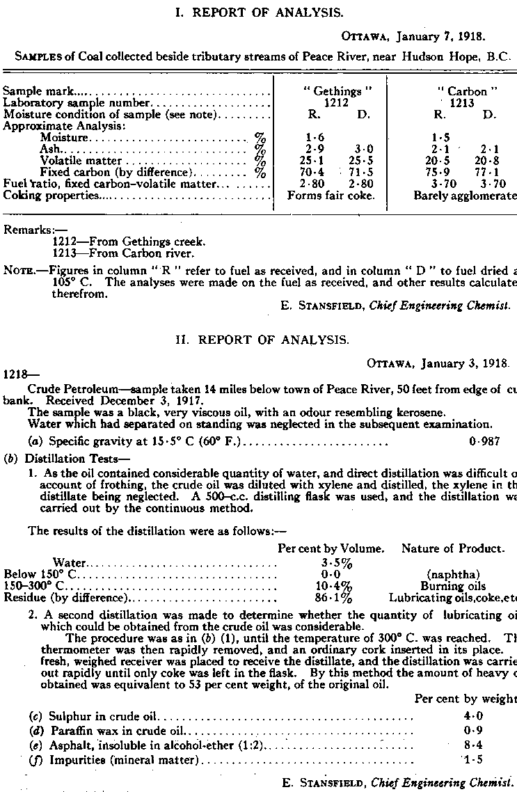
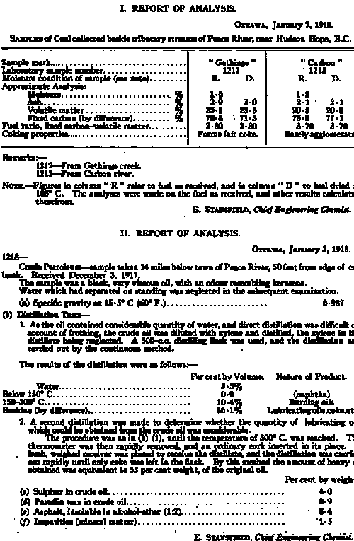
Two samples of coal from near Hudson Hope, and a sample
of crude oil from the McArthur well near Peace river, were submitted to
the Director of the Mines Branch, Department of Mines, for examination.
The reports of analyses made by the Chief Engineering Chemist of the
Division of Fuels and Fuel Testing of this branch are shown following:—
Fur
Since the feet of the white man first trod this district
it has been a continual source of wealth in fur and game. Over one
hundred years ago the Northwest Company and the Hudson’s Bay Company
were rivals for the trade, and to-day their old posts still remain in
active operation. These rival companies long since united and continued
as the Hudson’s Bay Company. The Revillon Company then invaded the
territory, and have posts scattered throughout the district; while, more
recently, other fur-buying concerns have been attracted to the field and
their posts have sprung up in various places. The buffalo of early days
provided both meat and robes, and there still roams the northern parts
of this district a small band of wood buffalo, survivors of the majestic
herds of yore. Moose, deer, and bear are now the larger animals hunted,
while smaller fur-bearing animals produce more profit from their skins
than did the buffalo in their time. The Beaver, Slavey and Chipewyan
Indian tribes live almost entirely from the chase, eating the meat and
trading the fur, while the Crees and half-breeds usually prefer to make
their living by trapping than by following farming or other pursuits. In
fact, so profitable has trapping become in late years, that many of
these people have given up promising farms to return to their old
haunts, which barely yielded a living a few years ago. These abandoned
farms may be seen in the Fort Vermilion district; the farms are good,
but the fur business is better, according to the Indian opinion. Many
white men also engage solely in trapping. Besides these regular
trappers, great numbers of settlers find in their spare time during the
winter that they can derive considerable revenue from this source, and
the homesteader’s boy attains ready pocket money and endless adventure
from his own enterprise in this line.
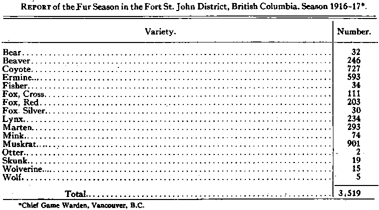
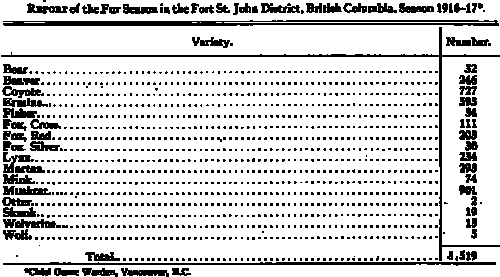
An indication of the variety and quantity of fur taken
will be obtained from the following table, which shows one season’s
catch in one small district:
While the district abounds in fur-bearing animals, it is
not so lavishly provided with fish. The mountain streams, however,
contain trout. Moberly lake, though small, is well stocked with
whitefish, as is also Sturgeon lake. Peace river produces a few fish,
chiefly ling and gold eyes. The Caribou lakes, north of Fort Vermilion,
teem with large trout and whitefish, and will yield enormous quantities.
As yet these lakes are difficult of access. The Wabiskaw and Peerless
lakes are also well stocked, but lie in a district remote from
settlement.
In feathered game, wild ducks, geese, swans, and wavies
are plentiful. These are especially abundant on the Hay lakes northwest
of Fort Vermilion, and on the lower Peace and Athabaska. In the fall of
the year they gather in flocks of thousands, and the Indians kill great
numbers and hang them up to freeze for winter use. Prairie chickens and
partridges are found throughout the district, but are not numerous and
are being protected by the provincial Governments.
Moose and woodland caribou are fairly plentiful, but
other deer are rarely seen. Wolves, bears, coyotes, and foxes afford
exciting chase for the sportsman and an opportunity at the same time to
rid the settlers farmyards of invaders.
Many misleading statements have been published relating
to the vast amount of power available on the Peace river. This river,
from the canyon in British Columbia to Vermilion chutes in Alberta, a
distance of approximately 500 miles, is a wide swift river flowing over
a sand or gravel bed, generally shallow, and through a deep valley, with
gently sloping sides. The river is a mountain stream, as are many of its
tributaries, and as a result the flow is very irregular, varying as much
as 50 to 1 between high and low water, with the floods occurring during
the summer months and the low flow during the winter.
On the Peace river there are two possible power sites:
one in the headwaters at the canyon, and the other at Vermilion chutes.
The canyon site has not yet been investigated by the
department’s power engineers, and while the total fall through the
canyon, which is about 18 miles in length, is reported to be between 225
and 275 feet, it is not known how much of the total head can be
developed. In any event, a power development at this site will be an
expensive undertaking, and can only be accomplished when a market for
the power is available close at hand.
The Vermilion chutes site has been surveyed and
investigated by the department’s power engineers. The river at this site
averages one mile in width, and takes a drop of 30 feet in a distance of
2 miles. The fall ia concentrated chiefly at two points; the first or
upper fall being in the form of a rapid, half a mile in length, with a
total drop of 11 feet. The second drop is situated one and a half miles
below the rapid, and is an abrupt drop of 13 feet over a limestone
ledge, and is commonly called the 11 chutes.
At the “chutes” both river banks are low, and an
effective head of 30 feet is about all that can be obtained. The
continuous 24-hour power available, based on one season’s discharge
records, amounts to 19,100 horse-power. For nine months of the year
possibly 27,300 horse-power can be developed.
The possibility of developing small blocks of power on
the tributaries of the Peace has not been definitely investigated by the
department’s engineers. Of these tributaries, the Pine, North Pine, and
Smoky rivers have their sources in the mountains and foothills and are
fed by the melting snows in the mountains during the summer months and
have only a small run-off during the winter. The Moberly, Pouce Coup6,
and Bear creek, together with the tributaries below Peace River
Crossing, depend upon the precipitation, are subject to floods during
the spring and summer months, and have a very small flow during the
winter. Further investigations may, however, reveal the possibility of
storing and conserving the flood waters on many of these streams. In
such an event, these streams will be capable of producing sufficient
power to operate small mills, and in some cases supply the power demands
of a small municipality.
The inherent disadvantages of the Peace river and its
tributaries as a source of power at the present time are:—
1. The irregularity of flow.
2. High cost of development.
3. Absence of market.
These disadvantages may, however, be overcome by:—
1. The creation of storage reservoirs to regulate the
flow.
2. By settlement in the district. As the district becomes
thickly populated and towns spring up transportation facilities will be
greatly improved and a market created for the power.
Transportation
The Peace River District may now be reached in comfort
and despatch by modern means of travel, being connected by rail with
Edmonton, the capital of Alberta. Peace River, Spirit River, and Grande
Prairie are served by the railway and further construction is in
progress. In addition, those districts adjacent to the river have the
benefit of a steamboat service during the months of navigation.
The Edmonton, Dunvegan and British Columbia railway runs
northerly from Edmonton to Smith, the first divisional point, where the
Athabaska river is crossed. Swinging westerly, it follows the Lesser
Slave river and skirts the southern shore of Lesser Slave lake, famous
for its yields of whitefish.
High Prairie is on the line of steel at the westerly end
of this lake, and marks the approximate divide between the Athabaska and
Peace watersheds.
The railway then runs more northerly to the next
divisional point, McLennan’ From McLennan the Central Canada railway
runs northerly to Peace river* reaching the edge of the valley at a
point overlooking the junction of the Peace and Smoky rivers and
affording the traveller an excellent bird’s-eye view of the town
nestling in the valley several hundred feet below. A long descent on a
side-hill grade brings one into the valley and to the edge of the waters
of the Peace itself.
From McLennan the main line of the Edmonton, Dunvegan and
British Columbia extends westerly, crossing the Smoky river and
continuing to Spirit River settlement. Location has been carried still
west as far as Pouce Coupe, and it is only a matter of time until the
steel will be laid across this prairie and thence through the mountain
passes to give an outlet to the Pacific coast.
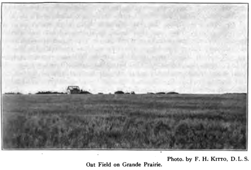
From Spirit River a branch runs southerly to Grande
Prairie, a new town which has sprung up in the heart of the great
prairie whose name it bears, and which has been settled so rapidly in
recent years.
At present a train service is maintained on all these
lines, from Edmonton and return, twice a week. Traffic is already
becoming so heavy that a daily train service is probably not far
distant. Stockyards and elevators are in evidence, and an efficient
freight service is maintained.
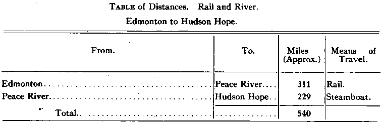
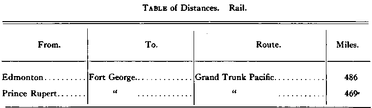
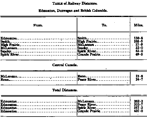
Distances are shown on the following table:—
Highways are being rapidly constructed and improved.
BridgesJiave been provided for smaller rivers, and ferries for the Peace
at Dunvegan, Peace River, and Fort Vermilion. Auto liveries ply
regularly between Peace River, Dunvegan and Spirit River, also between
Spirit River, Grande Prairie, and Saskatoon lake and Spirit River and
Pouce Coup6. These roads and trails, being chiefly on the prairies, are
easily made and kept in good condition.
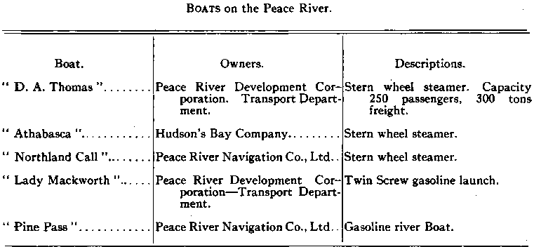
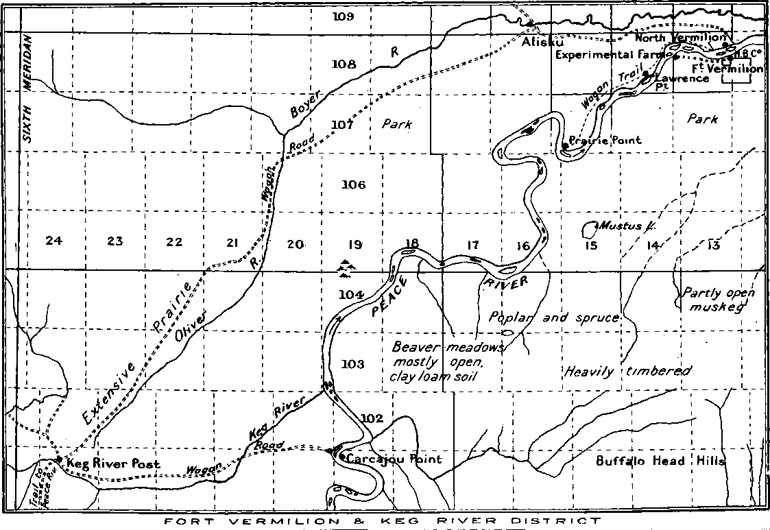
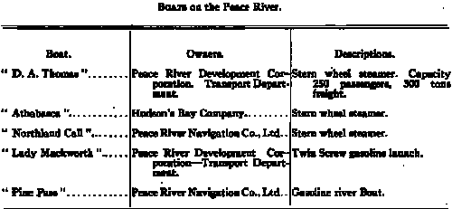
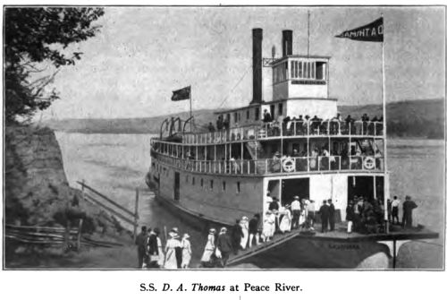
The principal boats plying on the
river are shown in the following table. These provide practically a
weekly service during the summer.
Communication
By the construction of a telegraph line from Edmonton to
Peace River the Dominion Government has overcome that dread of isolation
which kept many a prospective settler from entering this district at an
earlier date. The farmer of to-day is a business man, and demands means
of speedy communication regarding his business affairs.. Especially do
women, willing to brave other privations of a pioneer life, shrink from
being cut off from ready means of communication with their distant
friends, or from the current news of the day. Provision has been made to
meet these demands, the Dominion Government supplying an efficient
telegraph and mail service. In addition, the Government of Alberta owns
and operates a rural telephone system throughout the province, the
extension of which follows dosely upon the opening of new districts.
Mail is carried by the railway twice a week from Edmonton
to McLennan, Peace River, Spirit River, and Grande Prairie. From railway
points it is distributed by carrier to various post offices throughout
the district. Already about fifty offices have been opened, and the mail
service is constantly being extended and improved to keep pace with the
growth of the country.
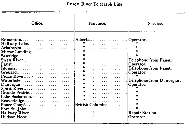
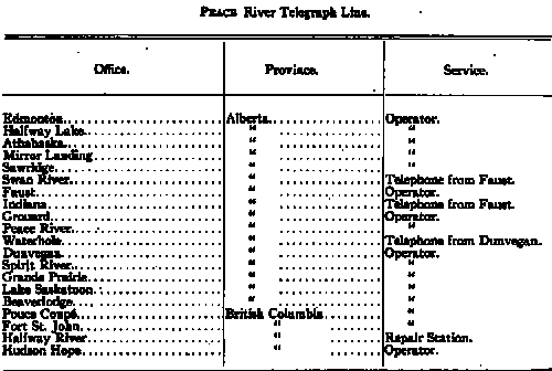
The Dominion Government telegraph line from Edmonton to
Peace River has been extended westerly to Dunvegan, Grande Prairie, Fort
St. John, Hudson Hope, and intermediate points, comprising in all 710
miles of line. The following table shows the stations thereon:—
Education and Social Life
The Public School system of Alberta applies to all
settled portions of the province, and provides free and competent
instruction to all children. The provincial Department of Education is
very much alive to the child’s intellectual and educational welfare. As
soon as eight children can be assembled in any district a suitable
building is provided and a competent teacher engaged to carry on the
work of instruction, as outlined by the department, under proper
inspection and supervision. In the towns and larger villages,
high-school studies are included in the curriculum. At Peace River and
Grande Prairie arrangements have been completed to carry the work up as
far as matriculation, so that the boy or girl may be prepared to enter
upon his or her college course without finding it necessary to leave
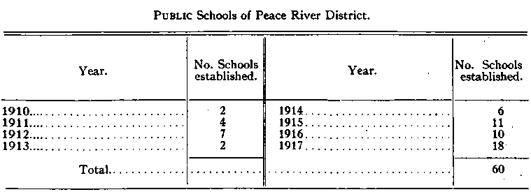
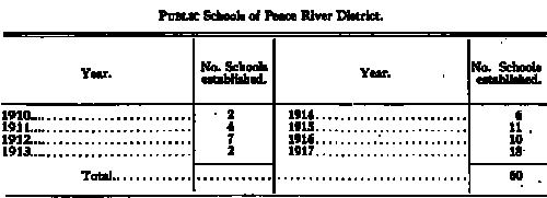
home for intermediate studies. Some sixty schools are now open
throughout the district. The average daily attendance for the year 1917
at Peace River town school was about sixty, while the attendance of
purely rural schools is somewhat higher than in many older-settled
districts. The following table shows the growth of the schools in this
district:—
Religious denominations are well represented. The Church
of England and the Roman Catholic church have been very active during
the past quarter century in mission work, and have established mission
schools among the Indians at Fort Vermilion, Shaftesbury, Dunvegan, Lake
Saskatoon, and Flying Shot lake. Methodist and Presbyterian churches
have been established at principal points, in many instances concrete
examples of Union being manifest. Other denominations and societies are
found throughout the district.
Fraternal and benefit societies are opening lodges in
principal towns. Peace River, Spirit River, and Grande Prairie have live
Boards of Trade eager to assist the welfare of the town and to welcome
the newcomer. Agricultural societies have been formed at various local
districts and annual fairs are held.
Two weekly newspapers are published at Peace River, one
at Grande Prairie, one at Spirit River, one at Clairmont, and one at
Lake Saskatoon. The ever-popular motion-picture theatre has made its
appearance in the principal towns. Boards of Trade, Farmers’
Associations, Women’s Institutes, Fraternal Societies, Athletic Clubs,
and other institutions tend to keep alive the spirit of an optimistic
people. Hospitals are established in Peace River and Grande Prairie.
Except in remote corners the settler need not feel at all
isolated. It has always been noticeable that in pioneer sections social
barriers are cast down, and a spirit of equality and brotherhood is more
evident than in older-settled parts. Peace river is no exception to this
rule, and the new-comer finds welcome and ready assistance from those
with whom he comes in contact, and rapidly makes new and staunch
friends.
The British Columbia Section
That part of the Peace River District falling within the
province of British Columbia, and exclusive of the 14 Peace River
Block,” comprises the portion controlled by the Government of that
province so far as ungranted public land is concerned. .It
is-practically embraced in the ‘'Peace River Land Recording District,”
the recording office of which is located at Fort George. This might be
called the mountain section of Peace river, and is divided from the
plains section by the Rocky Mountain canyon, which at Hudson Hope forms
an interruption to navigation. It includes the valley of the Peace, from
this point to its head; also the great valleys of the Finlay and Parsnip
rivers, together with the valleys of their many tributaries. Much of
this section is still unexplored, but many millions of acres of fertile
land are known to lie in its valleys, and untold mineral wealth remains
beneath its hills.
Small settlements are found about the various trading
posts and mining camps, of which the principal are Finlay Forks, at the
junction of the Finlay and Parsnip rivers; Fort Grahame, on Finlay
river; Fort McLeod, on McLeod lake; and some camps on the Omenica. As
yet the district is difficult of access and remote from civilization and
markets. The nature of the country is generally rugged and the climate
severe. The Omenica miners travelled over a pack route from Hazelton. An
easier canoe route is now available from Fort George, but much the
easier way is from Hudson Hope, which point can be reached by rail and
river steamboat from Edmonton in three days. The Rocky Mountain canyon
is passed by a 14-mile wagon road leading from Hudson Hope to the site
of old Rocky Mountain House, which once stood at the head of the canyon.
While this section is still practically in its primitive
state, it holds out very alluring promises for the future. Railway
surveys have been projected from the south and the east, and once the
steel penetrates the district it will open up very rapidly. Mixed
farming, dairying, and ranching will thrive as soon as markets are made
accessible. Mining will revive when means of transporting heavy
machinery is provided. Various rivers offer good inducements for
dredging, and quartz ledges have been discovered which could be milled
profitably, if machinery could be more easily taken in. The district is
known to be highly mineralized, and the field is an excellent one for
the prospector. The coal fields above Hudson Hope are believed to be
very extensive, and the quality is high grade.
Timber is also plentiful, and much water-power is
available. Fish and game are abundant. The scenery is magnificent, and
the summer seasons very delightful. The district is rich in fur, and
many prospectors scattered throughout its remote corners are combining
trapping with their quest for minerals. Their traps yield them a
livelihood until they have located paying claims.
With the coming of the steel, and the opening of coal and
other mines, this district will develop very rapidly. To those not
afraid to face a few years of pioneer work will come the opportunities
which await the man on the ground, when the great movement sets in.
The following are tables of distances of present routes:—

The Great Agricultural Sections
The Crown lands and natural resources of the Peace River
District included within the boundaries of the province of Alberta and
the Peace River Block of British Columbia are the property of the
Government of Canada. They are controlled by the various branches of the
Department of the Interior at Ottawa. To expedite transaction of
official business, this vast district has been divided into land
districts, and provided with local offices. Government agents are
stationed at these offices to give immediate attention to the disposal
of Dominion lands, the control of Crown timber, and the recording of
mineral claims.
The Peace River Land District extends from the Fifth
principal meridian westerly to the British Columbia boundary. Its
southern boundary follows the line between townships 84 and 85 across
ranges 1 to 3, between townships 68 and 69 across ranges 4 to 20, and
between townships 73 and 74 across ranges 21 to 26 west of the Fifth
meridian. West of the Sixth meridian its southern boundary is the Peace
River. Its northern boundary extends to the northerly limit of the
province of Alberta. This district also includes that part of the Peace
River Block lying north of the river. The agency is located in the town
of Peace River with sub-agencies at Fort St. John and North Vermilion.
Grande Prairie Land District includes townships 61 to 73,
inclusive, from ranges 21 west of the Fifth meridian to the Sixth
meridian. From the Sixth meridian it extends westerly to the British
Columbia boundary, and northerly from township 61 to the Peace river. It
also includes that part lying south of Peace river of the Peace River
Block. The agency is located in the town of Grande Prairie, with
sub-agencies at Spirit River and Pouce Coup6.
The tide of settlement to these districts has set in
practically within the last ten years. Prior to that only a few
scattered pioneers could be found about the various trading posts. The
attractions of the district, however, and the unbounded faith of its
pioneers gradually drew the attention of the outside world, and home
seekers began to make their way in over the long trying trail from
Edmonton. Undaunted by such hardships, they blazed the way for others to
follow and pressed forward to secure the choicest locations. Surveyors
were rushed into the district to lay out the lands, and before the
outbreak of the Great War, various localities of particular attraction
had become thriving centres of settlement.
Even since the outbreak of war the rush of settlement has
continued. Immigration from Europe having been suspended, the district
is receiving its new-comers almost entirely from older-settled parts of
Canada and various States of the adjoining Republic. Many returned
soldiers are now finding their way into the district to locate new homes
for themselves. The opening of a railroad and extension of navigation
has made the way easier during the last two or three years.
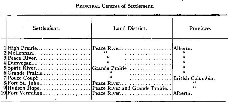
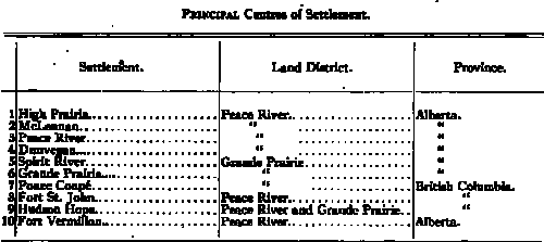
The principal centres of settlement, and the land
districts and provinces in which they lie, are shown on the following
table:—
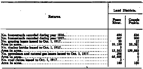
Some idea of the extent of settlement and development may
be obtained from the following table of miscellaneous figures taken from
official returns:—
A considerable area of excellent farming land, with
prairies at frequent intervals, is found about the west end of Lesser
Slave lake and on the divide between this lake and the Peace River
slope. Various settlements have grown up in this district, of which the
earlier were Lesser Slave Lake, Salt Prairie, Heart River, and Big
Prairie settlements. These were surveyed in settlement lots prior to the
extension of the regular system of township surveys. The old wagon road
from Edmonton to Peace River Crossing by way of Athabaska Landing
followed the south and west shores of Lesser Slave lake, and at the
northwest extremity, at the head of navigation, a trading post was
located. About this post has grown up the town of Grouard. From Grouard
the trail led northerly to Peace River. Lesser Slave lake has for many
years been famous for its yields of whitefish. These fish are caught in
the winter, and shipped in a frozen condition. Before the advent of the
railway they were freighted by team to Edmonton. Fishing, freighting,
and fur trading were occupations that brought large numbers of Indians
and hardy white men into this district. Great areas of hay lands along
the shores of the lake encouraged the settlers to raise cattle, and this
was followed by the cultivation of choice sections of prairie and
lightly wooded lands in the vicinity.
A land district embracing over 200 townships about the
lake was formed, and an agency established at Grouard for the
convenience of the settlers. When the railroad was built it followed
westerly about 20 miles beyond the lake before swinging north to Peace
River, and then paralleled these older settlements along the wagon road.
It crosses a few miles of beautiful prairie located on the height of
land between the lake and Peace River, which is now called High Prairie.
The old wagon road from Grouard to Sturgeon Lake crossed the same
prairie.

This prairie has been located and settled very rapidly
since the building of the railroad. About the depot established here has
grown up the town of High Prairie, where the Dominion Land Agency
originally located at Grouard was later established. This prairie gave
its name to the land district as well as to the town, the district
formerly called Grouard being known later as High Prairie Land District.
It has recently been absorbed in the Peace River Land District by the
enlargement of boundaries of the latter.
The soil throughout this section is good, being mostly
black loam with clay or sandy clay subsoil. Many patches of prairie
occur, but these are not extensive, except the hay meadows and marshes
found along Lesser Slave lake. The greater part of the section is
wooded. The woods range from light scattered poplar, with clumps of
willow, to thick spruce, jackpine, birch and poplar, up to 8 or 10
inches in diameter. The surface generally is level or rolling, but
numerous small rivers, with deep ravines, cut up many quarter sections
and render them unfit for cultivation. There is usually good pasture,
however, in these ravines.
All ordinary grains, grasses, and vegetables are grown in
this section. It is well adapted for mixed farming and contains much
good land open for settlement. This section is the first reached from
the south, High Prairie being but 234 miles by rail from Edmonton.
McLennan
McLennan is the second divisional point on the Edmonton,
Dunvegan and British Columbia Railway, being 262-2 miles northwest of
Edmonton. It is the southern terminus of the Central Canada Railway,
which runs 48-5 miles northerly to the town of Peace River. Both of
these railroads are being operated under the same system, thus affording
a through service to the north and west alike. From McLennan the main
line of the Edmonton, Dunvegan and British Columbia railway runs
westerly to Spirit River, crossing the Smoky river a few miles below the
mouth of Little Smoky river. The old wagon road from Grouard to Peace
River, over which the early settlers toiled from Edmonton, passes within
15 miles of McLennan to the east, so that this section was overlooked
entirely during the first rush.
Settlers found their way into the Spirit River and Grande
Prairie sections by way of Peace River and Dunvegan, a long, roundabout
route, though the only good trail. Later these same settlers, finding it
necessary to do considerable freighting to and from Lesser Slave lake,
and even Edmonton, located a shorter route from Spirit River to Grouard.
Their wagon road is now almost paralleled by the railroad. The Smoky
crossings are within 3 miles of each other, and the wagon road crosses
the same township in which McLennan is located.
With the opening of the wagon road from Grouard,
attention began to be directed to areas of splendid land lying between
Winagami and Kimiwan lakes, and the Smoky river, and settlement here has
been rapid since the laying of steel.
McLennan is located on the south shore of Kimiwan lake.
About this lake are large hay meadows. Northerly along the Central
Canada railway is found rich, level land with open patches, but
generally wooded. A number of locations have been made at Camelia and at
Reno, where the steel and the old Peace River wagon road converge to
within a mile or two of each other, with the North Heart river between.
Between McLennan and Smoky river there is excellent land, gently
undulating, with black loam on clay subsoil, and covered with light wood
and numerous patches of prairie. Township 78, range 21, west of the
Fifth meridian, is practically all located, and settlement is spreading
rapidly in all directions. The principal points are Donnelly, Faiber,
and Fowler. Heavier spruce woods are found along the Smoky.
Peace River
The town of Peace River, the hub of the great district
whose name it bears, has grown in a few short years from a rude
collection of divers small buildings, clustered about the old trading
posts, to a flourishing agricultural and business centre. The original
trading post was located a few miles upstream from the present town, and
about it the Shaftesbury Settlement blazed the way in grain growing in
the Peace Valley. The newer posts and the town are beautifully located
on sunny flats, nestling between high rolling banks immediately below
the junction of the Smoky and Peace rivers, and at the mouth of the
Heart.
Here the wagon road from Edmonton, winding its way down
the narrow gorge-like valley of the Heart, reached the Peace, and the
weary traveller caught his first glimpse of that great river whose name
had lured him on over the long trail.
A favourable spot for crossing the river was found at
this location, and for many years a cable ferry has been in operation.
The old Hudson’s Bay steamboat Peace River here exchanged great bales of
raw furs for supplies of all kinds which the freighters brought from
Edmonton. It plied up and down the river, supplying the lonely outlying
posts with provisions for a- new year and bringing out their fur catch
of the past year. The trail, interrupted by the river, resumed its way
westward, and after traversing the settlement of Shaftesbury, wound up
the hill to the high plateau above, which it followed as far as Dunvegan.
"Peace River Landing” and "Peace River Crossing” were
names variously applied in earlier days, but “Peace River” is now the
official name of the town. The trail from Edmonton has served its
purpose. The railroad now reaches the town, and the hardy freighter has
gone to new fields. The trail to Dunvegan is still a much-travelled
highway, as it serves a very fertile and thickly settled section of land
west of the town. It is in good condition, and automobiles are regularly
seen upon it. Grading has been commenced for the extension of the
railroad to follow this trail, as it has done from Edmonton, and the
erection of a mighty bridge to span the river is well under way at Peace
River town.
The Dominion Lands Agency for Peace River Land District
is located here, also the posts of the Royal Northwest Mounted and the
Provincial Police.
Railway, telegraph, telephone, and semi-weekly mail
service keep the town in touch with the outside world. Two weekly
newspapers are published. Schools, churches, a hospital, and an
immigration hall are among the public buildings.
Various places of business supply the needs of the town
and adjoining country. A Board of Trade and an Agricultural Society take
active interest in the building up of the district. Coal has been found
within 6 miles of the town, and gas and oil within 14. The extent of
these discoveries has not yet been determined, but development work is
being continued and, profiting by the experience of other localities, no
attempt is being made to “wildcat" them.
Excellent farming land extends from the west side of the
river right through to Dunvegan, the Sixth meridian being located
midway. The chief centres of settlement in this part are: West Peace
River, Shaftesbury, Bear Lake, Paul’s Corners, and Griffin Creek. North
of West Peace river and Bear lake there is good land open for settlement
as far as Whitemud river. A wagon road extends farther north to Battle
or Notikewin river. There is excellent prairie land here, surrounded by
fairly heavy timber. Practically no land has been taken up yet in this
part. During the season of navigation the Battle prairies can be easily
reached by steamer. A wagon road leads from the steamboat landing near
the mouth of the river into the heart of the prairie, a distance of 25
or 30 miles. Supplies are available at the trading post at the landing.
The land surrounding the town of Peace River, on the same
side of the river, is rough and broken by the junction of the Smoky and
the Heart rivers with the Peace. There is, however, much good grazing
land in numerous valleys and ravines. On the plateau above the valleys
the soil is good but mostly wooded, and has some muskeg and marsh. While
the choicest prairie locations have been pretty well taken up in this
section, there are thousands of acres still available of land just as
good, though requiring more work to bring under cultivation.
Since the completion of the railroad from Edmonton to
Peace River, the northern trade has increased very rapidly. Tourists are
now able to go by rail and steamboat into the great Mackenzie and Arctic
regions. Trappers, traders, and prospectors are continually coming and
going, and during the season of navigation Peace River has become a busy
shipping point. Railroad surveys have been projected northerly to Fort
Vermilion and Slave lake, and when the resources and beauties of the
north become better known it is expected that this town will play an
important part in its development.
Dunvegan
Over one hundred years ago barley, potatoes, and several
varieties of garden vegetables were grown by the employees of the
Northwest Company on the river flats adjoining their post at Dunvegan.
The results are said to have been very satisfactory. Grains, grasses,
and vegetables are now grown extensively in all sections around this
early starting point, and the district is fast developing into one of
the most promising portions of the country.
Dunvegan itself is still merely a Hudson’s Bay post. It
is located on the north shore of Peace river, 61 miles above the town of
that name, and 18 miles by trail from Spirit River. The valley here is
narrow and about 800 feet deep. A ferry has been installed, and is
operated during the open season at the point where the wagon road
crosses. The southern banks of the valley are thickly wooded. These
woods, however, extend only a short distance beyond the top of the bank,
when they give way to the Spirit River prairie. The northern banks are
rugged and broken, and almost bare of trees. The plateau above comprises
a very extensive area of excellent land.
Unfortunately Dunvegan has been “boomed” and “townsited”
in advance of any reasonable necessity. The farm lands, which represent
the real value of the district, lie on the high plateaus to the north
and south of the river valley. These lands are exceedingly fertile,
level or gently rolling, prairie or nearly open, rich in soil and well
watered. They represent some of the finest wheat-growing , sections of
the world. A half-section of this land, faithfully cultivated, will
prove a real source of revenue and wealth to the investor, as
distinguished from the wildly speculative “townlots,” whose corner posts
stand out in gaunt array on the wind-swept hillsides overlooking the
little cluster of whitewashed log buildings in the valley below, which
constitute the present “town.”
North of Dunvegan there is excellent land as far as the
Clear Hills, while easterly along the old trail from Peace River, some
of the best improved farms of the province are to be seen. The land has
all been thrown open for settlement; very little is held in any form of
reserve; consequently settlement has been uniform, and no “ gaps ” have
been left. Good roads, telegraphs, telephones, schools, and churches are
among the advantages of this district. The buildings and fences are in a
remarkable state of advancement for a new district. In fact, this can no
longer be called a “new district.” It has passed its pioneer stage and
settled down to a prosperous well established community.
Between Dunvegan and the Sixth meridian the principal
centres are Water-hole, Vanrena, Friedenstall, and Bluesky. Finer farms
cannot be found in any part of the West than in the vicinity of these
villages. East of the Sixth meridian this fine settlement extends to the
town of Peace River.
Spirit River
The Spirit River prairie is not extensive, but comprises
a few townships of excellent farm lands on a high plateau on the south
bank of the Peace river, opposite Dunvegan. It was formerly reached from
Edmonton by way of the Peace River Crossing and Dunvegan wagon road,
being on the route that extended from Dunvegan to Lake Saskatoon.
Trading posts have carried on business here for many years, the fur
trade with the Indians having been extensive. About these posts a
settlement grew up, which was surveyed as. such in 1907. Township
surveys were extended in 1909, and settlement rapidly followed.
The soil is a rich, deep, black loam, and vegetation is
very luxuriant. Wheat, barley, oats, and all common vegetables yield
abundantly. The surafce of the country is level or gently rolling, with
an altitude of 2,400 feet above sea-level. It comes within the influence
of the warm “Chinook" winds, and is well adapted to mixed farming and
stock raising.
The town of Spirit River is the present terminus of the
main line of the Edmonton, Dunvegan and British Columbia railway.
Location and grading have been produced about 60 miles farther west, and
a branch line runs south to Grande Prairie. Elevators and other shipping
facilities provide ready outlet for farm produce. By the old wagon route
it is 18 miles to Dunvegan and about 83 to Peace River town. This road
is in good repair, and much used by automobiles. Auto liveries ply
regularly between Peace River, Dunvegan, and Spirit River, between
Spirit River and Pouce Coupe, and between Spirit River and Grande
Prairie points. The section is well served by good roads and railroads,
and presents a very prosperous appearance. It is surrounded by lands,
partly broken and fairly heavily wooded, but with fertile soil
everywhere. Much good land is still available, but will require more or
less clearing.
The town is well provided with schools and churches,
telegraph and mail service, sawmills and business establishments, and
has a Board of Trade actively engaged in furthering the interests of the
district and assisting new comers to locate.
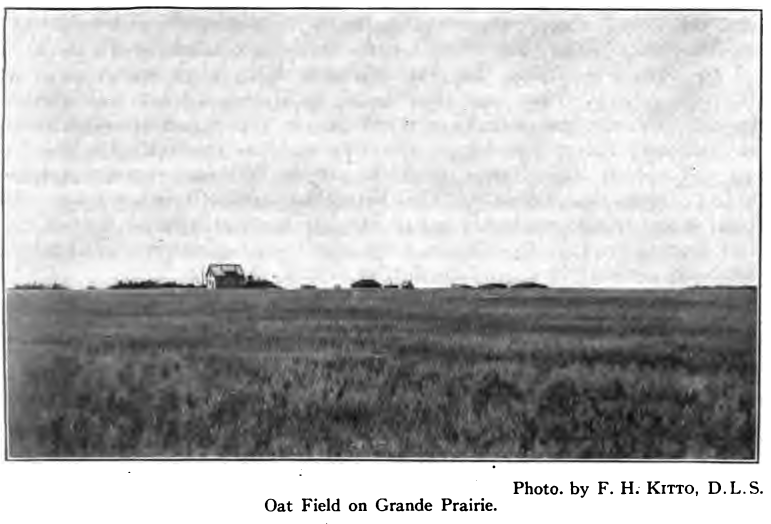
Grande Prairie
This famous district comprises a vast prairie lying on a
high plateau south of Peace river and between the Sixth meridian and
British Columbia. It is bounded on the south by the Wapiti river and on
the east by the Smoky river. Along its north runs a rough and wooded
ridge dividing it from the Spirit river and Pouce Coupe prairies.
Westerly it extends to the foothills of the Rockies. Its area exceeds
two thousand square miles of as fine wheat growing land as can be found
anywhere. The surface is level or gently rolling and the soil is a deep,
rich, black loam on a clay subsoil. The valleys of the rivers and the
outer edges of the district are wooded, but the main area is either open
prairie or very lightly covered with bluffs of poplar and brush.
Grande Prairie has been settled within the last five to
seven years. The main prairie and many choice adjoining spots have
already been taken up. Settlement, however, continues to pour into the
fringes of the district, where the presence of good soil outweighs the
disadvantages of bush and small timber which must be cleared off before
the land can be broken. Settlers are now taking up land along the
Beaverlodge and Red Willow rivers, going >as far as 55 miles west of
Grande Prairie station. Excellent land is found in these sections, and
several large farms are already in full operation, one farmer having 500
acres of crop this year. There is still good land open for homesteading
here, but it is fast being taken up.
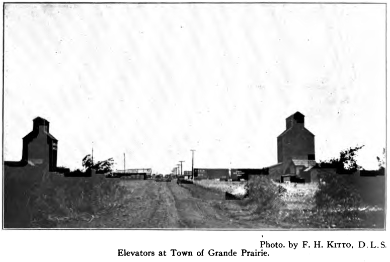
The Grande Prairie district is reached by a branch line
of the Edmonton, Dunvegan and British Columbia railway from Spirit River
running Southerly to within a few miles of Wapiti river and near Flying
Shot Lake settlement. About its terminus has grown up the town of Grande
Prairie, which has become the centre of business for the district whose
name it bears. It is a thriving western town, and contains three
elevators, a flour mill, several good stores and hotels, bank, large
two-story graded school, hospital, churches, immigration hall, creamery,
and other enterprises.
The Dominion Lands and Crown Timber office for Grande
Prairie Land District is located here. Telegraph and telephone
connections with Edmonton and local points are available. A weekly
newspaper is published. A Board of Trade and an Agricultural Society
take a live interest in furthering the welfare of town and country.
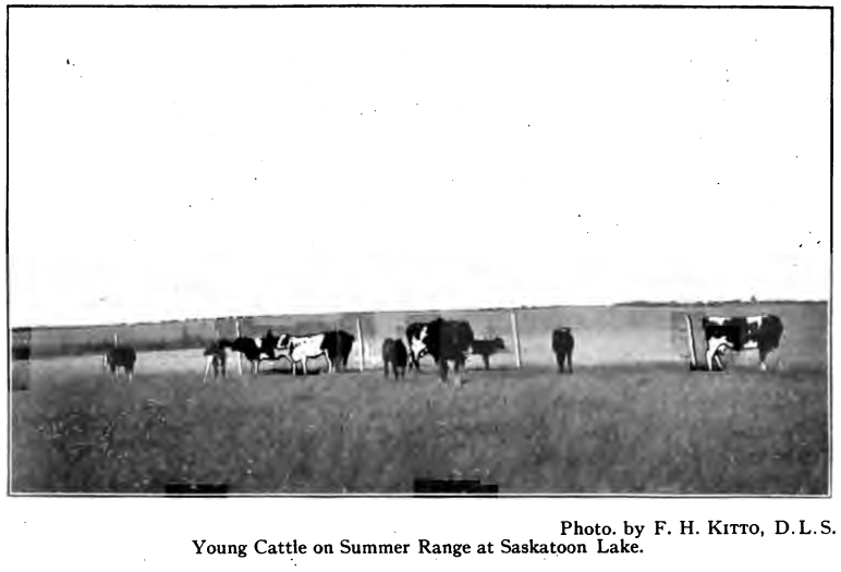
Lake Saskatoon, 14 miles west of Grande Prairie, is a
small village growing up around the old trading post located on the bank
of Saskatoon lake. Its location is both beautiful and historic. In the
heart of the prairie it commands a sweeping view, for miles in all
directions, of waving fields of grain where but a few years ago all was
wilderness. Before the building of the railroad it was the distributing
point for the district, being the last post on the old Edmonton-Peace
river-Dunvegan wagon road. Railroad surveys have been projected from the
south to this point, but no construction has yet taken place. In
addition to the Hudson's Bay, Revillon's and the Peace River Trading
Company's posts, there are various other places of business, also a
bank, a weekly newspaper, post office, telegraph office, schools and
churches.
Bear Lake lies about 9 miles northwest of the town of
Grande Prairie, and is surrounded by land in a very advanced state of
improvement and high cultivation. Here may be seen vegetable and flower
gardens which canrlbt be surpassed' for variety and yield anywhere in
the West. Even ornamental and fruit trees and shrubs, grown from seed,
are progressing quite satisfactorily.
Smoky and Wapiti rivers have deep valleys heavily wooded,
and for some miles on either side of these valleys the land is rough and
broken, though much of it is good for grazing. At the junction of these
rivers, 20 miles east of Grande Prairie station, is the village of
Bezanson, about which the land is very good. North and east from
Bezanson there is good land, mostly lightly wooded, extending to
Sturgeon Lake and High Prairie.
Clairmont and Sexsmith, on the railway line, are
springing up into flourishing little towns in the midst of a
well-improved section. Other centres are Kleskan Hill and Glen Leslie,
lying between Grande Prairie station and Bezanson, Spitfire Lake, Niobe
and Hermit Lake, centrally located, and Valhalla, Hythe, Beaver-lodge,
and Halcourt, situated towards the western limits of the district.
At Beaverlodge, the Experimental Farms Branch of the
Dominion Department of Agriculture has been carrying on experimental
work for several years, under the immediate supervision, and on the farm
of Mr. W. D. Albright, with good results. Arrangements have been made to
carry on this work on a much larger scale in the future, the experiments
to include work with forage plants, cereals, and horticulture.
Pouce Coupe
The Pouce Coupe prairie lies in the south-eastern part of
the Peace River Block in the province of British Columbia. It comprises
several townships of gently rolling prairie and a number with scattered
bluffs and light woods. The extent of this choice area is about 25 miles
wide by 40 miles long. It is separated from Spirit River and Grande
Prairie by high wooded plateaus on its east and south. To the north and
west it extends to the rough wooded banks of the Peace and South Pine
rivers. It is now reached by a good road from Spirit River.
The, location of the main line of the Edmonton, Dunvegan
and British Columbia railway passes through this district from east to
west. Grading has been completed from the end of steel at Spirit River
to Pouce Coupe village, a distance of about 55 miles, and steel will
shortly be laid. With railway facilities, this district promises to be
one of the finest yet opened. Upon development of the coal and other
resources of the upper sections of the Peace, and the completion of
railway connection to the coast, undertakings which are but a matter of
time, the value of this section will be further enhanced. The principal
centres at present are Pouce Coupe and Rolla.
The Pouce Coupe country is an ideal place for ranching.
It is an elevated plateau of about 2,400 feet above sea-level, lying
immediately to the east of the Rocky mountains and foothills. The soil
is very rich, and wild hay and peavine grow adundantly. The influence of
the warm “Chinook" winds is very marked. They sweep through the mountain
passes and flood the entire district, from time to time, during the
winter, removing the snow and giving pleasant respites from the cold.
Even aside from these warm waves, the winters are short. Stock pasture
out the year around, and the summers are particularly clear and fine.
Wheat and all ordinary grains, grasses, and vegetables yield abundantly.
The seasons are particularly free from summer frosts and hail, and the
climate generally is very pleasant.
Fort St. John
Fort St. John is on the north bank of Peace river, on a
small flat at the foot of steep rugged banks some 800 feet high. It is
178 miles by river above Dunvegan, and lies in the Peace River Block in
the province of British Columbia. A wagon road from Dunvegan to Hudson
Hope passes through it, and there is also a pack trail from Pouce Coupe.
It was established decades ago as a Hudson’s Bay post. Later another
trading post was opened which is now operated by Revillon Freres. The
provincial police of British Columbia have established a station here,
and the Dominion Government a telegraph office. There are usually a
number of Indians encamped about the post, as this is a rich fur
district, and extensive trading is done.
The Fort St. John district that is attracting farmers and
ranchers lies north of the river on a high plateau. The land is level,
and mostly open or very lightly wooded. The soil is good, and vegetation
very luxuriant. Wild grasses and peavine grow in great profusion. The
North Pine river lies to the north and east, and enters the Peace about
20 miles below the Fort. Its valleys are deep, and its many tributaries,
with their deep ravines, tend to break up much of the country and make
it too rough for grain growing. These valleys and hillsides afford good
grazing. Taken on the whole, this district is well adapted to mixed
farming and ranching. The snowfall is light, and the Chinook winds keep
the hillsides bare nearly all winter, making it possible for stock to
graze out.
The district is still remote from markets and
civilization, but several families have recently located there, being
attracted by the bracing climate and the fertility of the soil. With the
extension of railways and development of the many resources of the upper
Peace river regions, this section may be expected to be rapidly settled.
Hudson Hope
Hudson Hope is located on Peace river near the westerly
limit of the Peace River Block. It is the gateway from the great plains
to the mountain regions, being at the foot of Rocky Mountain canyon,
where the river bursts through from the foothills to pursue its placid
course beyond. In early days a trading post called “ Rocky Mountain
House ” was located at the upper end of the canyon. This was replaced by
a post at the foot of the canyon, about which two other trading posts
and a few scattered buildings have sprung up. These constitute the
present Hudson Hope. Steamboats ply up and down during the open season
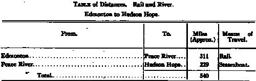
from the town of Peace River, some 229 miles, and there is considerable
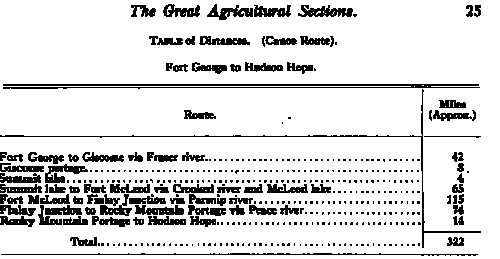
travel by canoe from Fort George. This route, by canoe and portage, is
about 322 miles. A wagon road, some 14 miles in length, leads past the
canyon to the upper waters of the Peace, which are navigable for
steamers. Various trails lead out to the haunts of the trapper and
prospector, for this district is rich in fur and has wonderful mineral
possibilities. Great deposits of coal are known to exist above the
canyon, and indications of various precious metals are in evidence.
On the plateaus on both sides of the river there is
considerable good agricultural land. The soil is sandy loam, and the
surface is gently rolling and lightly wooded. A trail leads south 18
miles to Moberly lake, where there is some excellent soil and luxuriant
pasture. This lake is filled with whitefish. There is an Indian reserve
at each end of it, but very few white settlers.
A number of homesteads have been located about the post,
and a few along the river flats between the post and Fort St. John. On
these flats the land is excellent and very heavy yields of grain and
vegetables are harvested every year.
Hudson Hope is now provided with telegraphic service, the
Edmonton-Peace River government telegraph line having recently been
extended through to it. It holds a very strategic position, and may
become an important point when this part of the territory is developed,
but at present is well in advance of settlement and does not warrant any
boom.
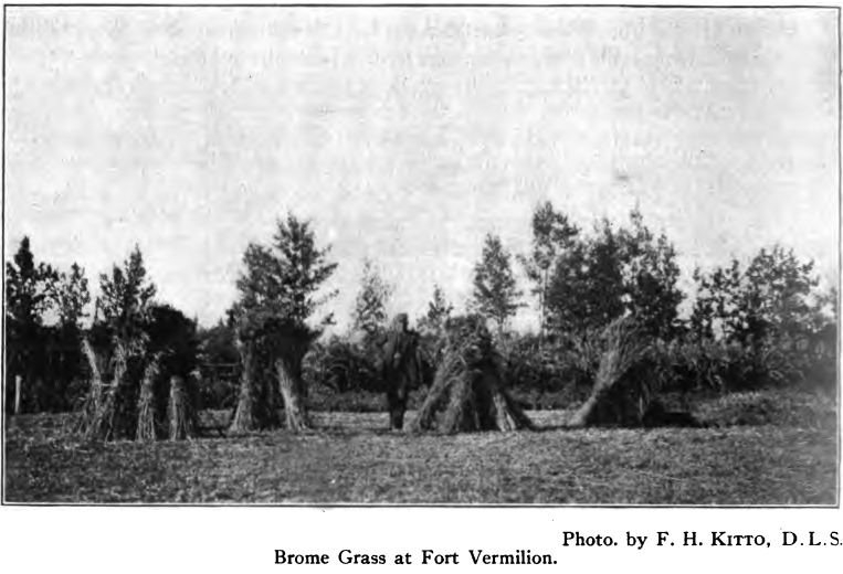
Fort Vermilion
The last great area of virgin plains still remaining
practically untouched by the tide of settlement which is sweeping over
other portions of the Peace river district lies away to the north around
the old trading post of Fort Vermilion. Last to receive its share of
this human tide, and yet first to let the world know of its riches and
possibilities, this primitive post still stands guard in the heart of a
vast solitude which will soon echo with the busy life of thousands of
homes. Beautifully situated on the low, broad valley of the Peace, where
the waters are wide and placid and the high steep bluffs have given way
to gently sloping banks scarcely higher than the valley itself, the
quaint cluster of buildings stands out in bold relief and presents an
inspiring front.
The simple daily routine of duties, the quiet methodical
trading-post customs, the little groups of Indians loitering about the
post, or the flutter of excitement when the steamboat whistle is heard,
give the traveller a pleasant glimpse of that life so closely associated
with the early settlement of the west, when the trader was monarch of
all he surveyed. Located about 250 miles north of the town of Peace
River, cut off from the outside world except for steamboat service
during a few summer months, and with its interest focused on the fur
trade of its own great district, the little post has lived its own life
and retained its simple customs far from the stress and worry of greater
centres. The dawn of a new era is just approaching, but the transition
will be rapid.
About the post are clustered the Hudson’s Bay buildings,
including a modem 50-barrel roller flour mill, steam driven and electric
lighted, and a saw and shingle-mill; the Roman Catholic mission; to the
east the English Church mission; to the western end of the flat the new
post of the Peace River Trading Company; and on the opposite side of the
river at North Vermilion, Revillon’s post. A few scattered farms are
being worked, the missions and Indians cultivating some choice land.
Aside from these only a few settlers, about half a dozen, are on the
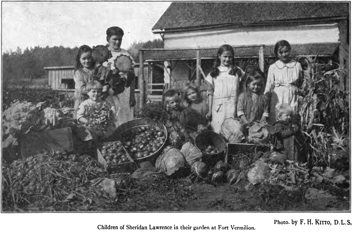
land. Two striking farms, a few miles up river, the Lawrence farm at
Lawrence Point and the Jones farm at Stoney Point, have for twenty years
been producing all varieties of grains and vegetables. For over a
quarter of a century, wheat has been raised about the post, and the
possibilities of the district have long since been established.
For 150 miles along the river, from Carcajou to Vermilion
chutes, and extending 25 or 30 miles on either side, lies one of the
most fertile plains of the American continent. The surface is level or
gently rolling, and the soil is a rich deep loam on a sandy clay
subsoil. Many hay meadows are found, and a small percentage of the
surface is light muskeg. A few sandy ridges occur, usually covered with
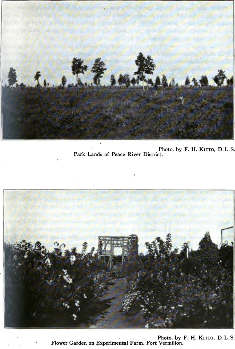
jack pine. Much, of this area is prairie, but the predominating feature
is its park-like nature. Bluffs and small clumps of poplar and birch,
with patches of open prairie intervening, or extensive prairies with
occasional small poplars scattered singly here and there, is the
prevailing nature of the surface.
Spruce and heavier poplar and cottonwood are found along
the waterways. Willow, alder, and other bushes are found on low land but
are not as plentiful as
in the Edmonton district. Building logs, fencing
material, and fuel can be found within easy distance of any location,
while the shelter for stock obtained from the light woods is an
advantage the bald prairie does not possess. Most of the land requires
but little clearing, and the soil is remarkably easy to break. The
choicest park lands comprise over a million acres, while another two
million acres of excellent land will require but little clearing to fit
it for cultivation. There still remain several million acres of good
lajid, fairly easy to clear or drain, and which, when brought under
cultivation, will give excellent returns.
The luxuriant growth of all vegetation, and the rapidity
with which it matures, seem remarkable considering the latitude of the
district, Fort Vermilion being in latitude 58° 25' north. The altitude,
however, is low, being about one thousand feet above sea-level, which
offsets, to a certain extent, the northern latitude. The length of day
during the summer season also hastens vegetation, the summers, though
short, having almost continual daylight. Summer frosts and hail are very
rare, and crop failures frpm any cause are unknown.
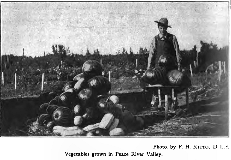
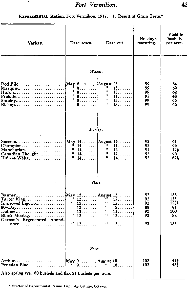
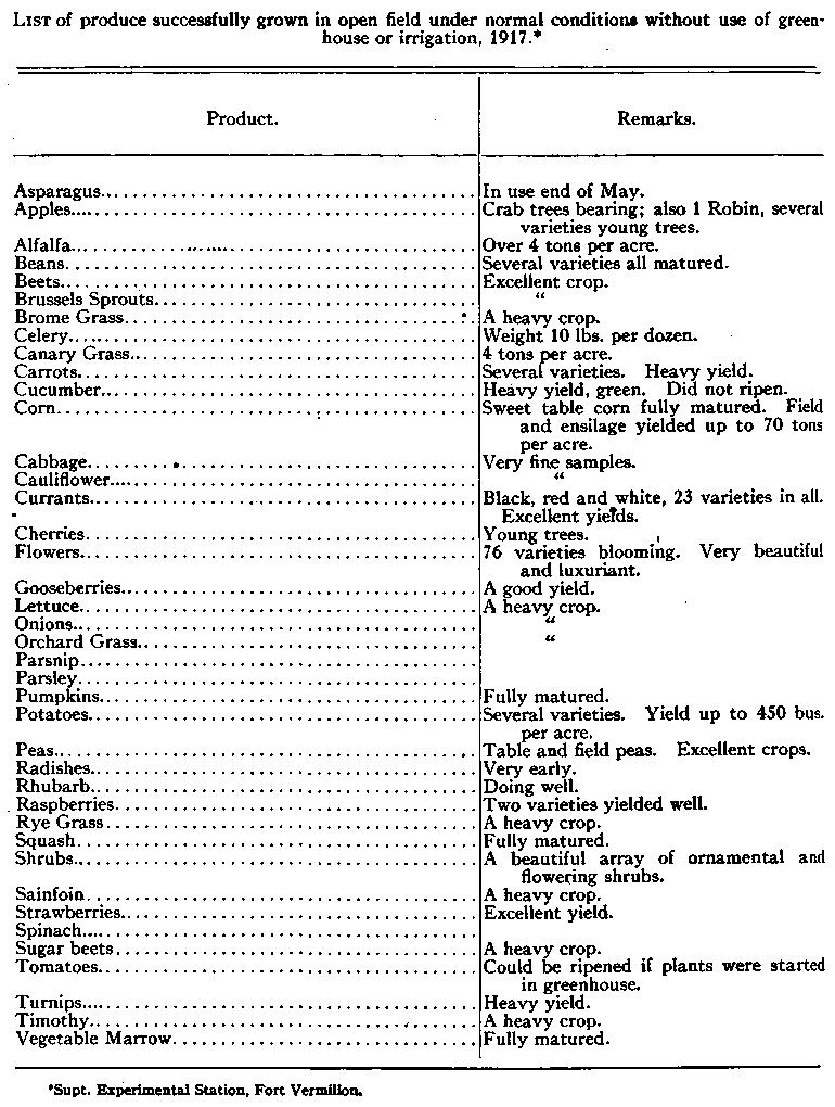
The Dominion Government has established an experimental
station under the immediate supervision and on the farm of Mr. Robt.
Jones at Stoney Point, and during the past eight years extensive tests
have been made to determine the degree of success which could be
obtained with various cereals, forage plants, fruits, and vegetables
under normal conditions. The results have been most gratifying. On the
Sheridan Lawrence farm a stone flour-mill has been in operation for over
twenty years, and a roller mill has been lately installed. Flour made
from wheat grown in this district has been supplied to the northern
trade continuously, and great quantities were disposed of to the
Klondike miners during the rush of ’98. A shipment of 9,000 bushels of
wheat was made from the Lawrence farm to Fort William in the spring of
1917, and created wide interest. The long haul and high freight rates
were overcome by the high price prevailing at that time. This is not a
normal condition, however, and until railway facilities are provided for
shipping the grain, this district must find its markets nearer home. The
northern trade, rapidly expanding, will provide markets for many years
to come.
While the district is exceptionally well adapted to wheat
growing, it is also well suited to stock raising and mixed farming.
Keeping in view the market possibilities, it should prove an excellent
field for mixed farming, dairying, and small cattle ranches. The Keg
river valley contains thousands of acres of the finest grazing lands to
be found anywhere. The Hay river valleys, Hay Lake prairies, and Buffalo
Head hills also contain much excellent grazing land.
The Hudson’s Bay Company have outposts at Red River, a
few miles below Vermilion chutes, at Hay river and Keg river, and also a
warehouse at Carcajou. Revillon Fr£res have outposts at Hay river and
Keg river, with a warehouse at Carcajou. The Peace River Trading Company
also has an outpost at Hay river, which is reached by a wagon road
running about 100 miles north-westerly from Fort Vermilion. The fur
trade at this outpost is very extensive, it being the chief trading
centre of the Slavey tribe of Indians, whose hunting grounds extend from
Hay lakes to Great Slave lake. Between this post and Great Slave lake
are found the wonderful Alexander Falls, whose height and beauty rival
the mighty Niagara.
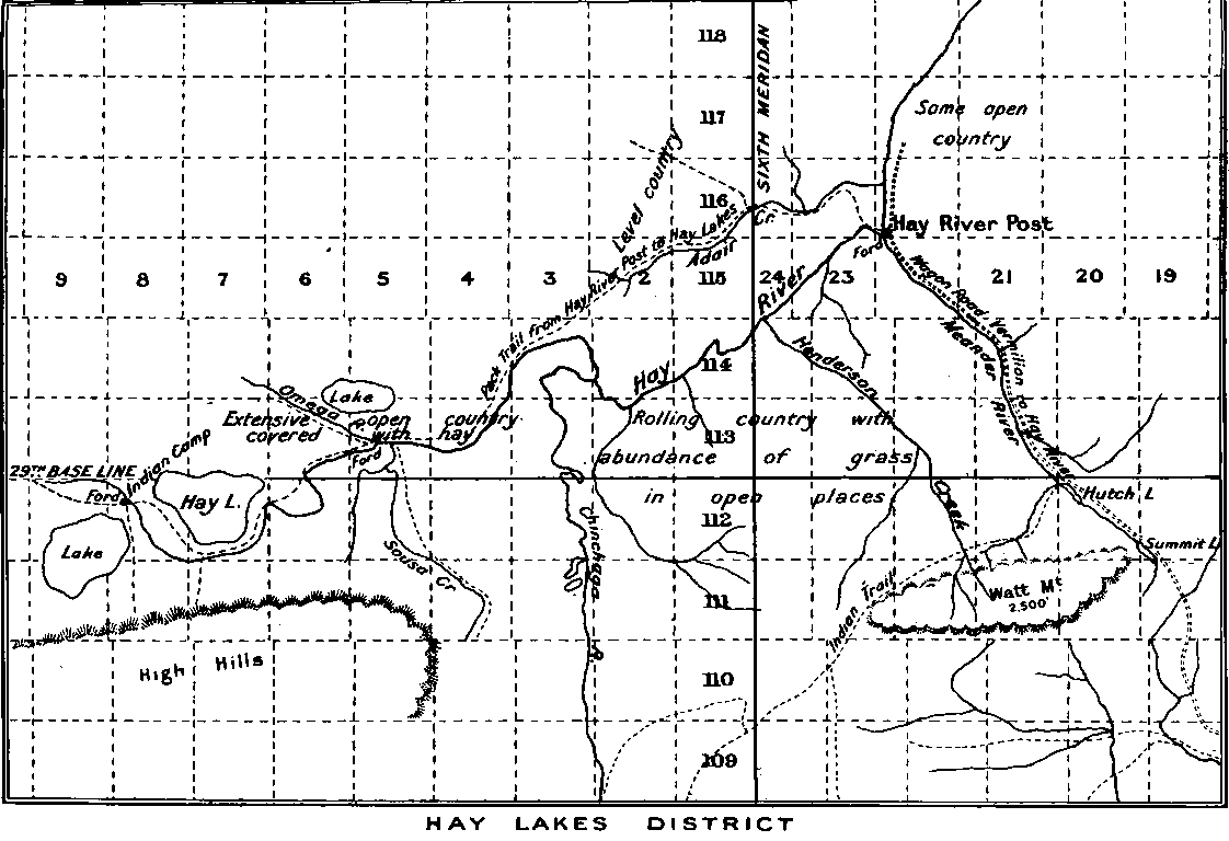
Westerly from the post, a pack trail leads about 75 miles
up stream to the Hay lakes. About these lakes lies an extensive plain,
level and fertile, and producing yearly hundreds of thousands of tons of
hay. Much of this area, however, is low and wet and subject to annual
flooding, which renders it unfit for grazing the year round. Along the
wagon road from Fort Vermilion to Hay River post for the first 50 miles,
is found the finest wheat land one could wish to see, Buffalo Prairie
being a particularly beautiful stretch of country. The divide between
the Peace and Hay watersheds is high and stony, and stony land is also
found for the remainder of the distance to Hay River post, but it is
covered with a luxuriant growth of wild hay and peavine. It is well
watered, and would make an excellent ranching district. The Watt
mountains lie immediately to the west, and are well wooded.
A good wagon road leads from Fort Vermilion to Keg River
post, and from the post to the bank of the Peace at Carcajou. Along this
road the land is exceptionally good. A little heavy bush is encountered,
and many large hay meadows are seen where the Beaver Indians make hay
for their horses. For 30 miles before reaching the post the road runs
through one of the finest ranching valleys to be found anywhere, covered
with peavine waist high, watered by a good strong stream, and sheltered
by woods on either side. Thousands of cattle could graze out here the
year round.
From Keg River post a pack trail runs to Battle or
Notikewin river from whence it is widened out again to make a wagon road
to the town of Peace River. Steps are being taken to cut out this last
section of pack trail so as to give a wagon road from Peace River to
Fort Vermilion.
South and east of Fort Vermilion, numerous trails lead
across the great stretches of beautiful rolling land extending to the
Buffalo Head hills and the Wabiskaw river, where rich grazing lands and
valuable timber areas are found.
This great district has wonderful possibilities and a
delightful climate. At present it is difficult of access, except in
summer time, and cut off from other sections of the Peace River District
and the outside world. It is reasonable to expect that within a short
time a good wagon road from Peace River will be provided. With a mail
and stage service operating on this road the year round, this objection
will be removed to a large extent. Railway explorers have been looking
over various routes into the district, and even beyond, as far as Great
Slave lake. No doubt in time steel will be laid through the district,
but this cannot be depended upon as an immediate move.
The following tables prepared from data supplied by the
Director of Experimental Farms speak more forcibly of the possibilities
of the Fort Vermilion district than mere words:—
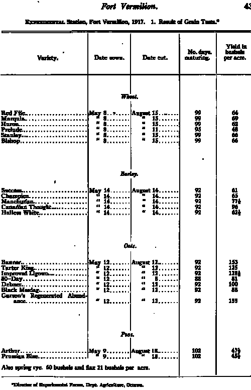
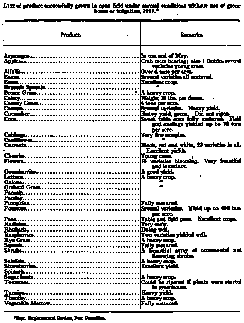
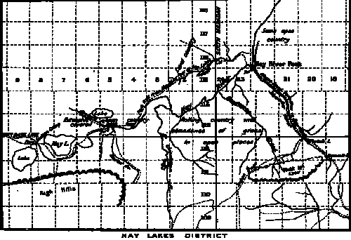
Publications and Information Available
The Government of Canada and the provincial Governments
of Alberta and British Columbia offer all reasonable inducements and
assistance to encourage the development of the Great Peace River
District. Progressive steps have been taken to open it up by
establishing lines of communication and transportation on land and
river, and by building roads and bridges. Telegraph, telephone, and mail
service keep it in touch with the older parts of the country. Law and
order are rigidly enforced and maintained, and life and property
efficiently protected. Educational and social advantages are provided.
Advice and assistance is given the homesteader in the choice of his
location, the methods of farming his land and the securing of his live
stock. Crown lands are given free to homesteaders on complying with easy
conditions; minerals may be staked and recorded on payment of small
fees; and, generally speaking, he who assists in the development of the
country may reap his own reward. The resources are there, and the
district offers them to bona fide settlers who will make their homes
there and become citizens of the Great Empire of which this corner is
but a small part. To those who are willing to faithfully undertake a few
years of pioneering, the opportunities for success are indeed promising.
Various useful maps and publications are available for
free distribution, in addition to copies of official regulations
relating to the disposal of resources.
When writing for maps the applicant should endeavour to
state specifically the scope which it is desired such maps should cover.
Requests for information concerning any particular locality should be
made to the local Agent of Dominion Lands. For information of a general
character, maps, and particulars of the regulations governing the
disposal of Dominion lands, timber berths, grazing leases, mineral
rights, water-powers and irrigation schemes, applicants should address
the Natural Resources Intelligence Branch, Department of the Interior,
Ottawa. This branch will, where necessary, refer without delay queries
requiring the special attention of any other office to the proper
authorities. Reports of the Experimental Stations at Fort Vermilion and
Beaverlodge, and general information pertaining to agriculture, are
available from the Director, Experimental Farms, Department of
Agriculture, Ottawa. The Deputy Minister, Mines Department, Ottawa,
should be addressed for reports relating to mineralogy and geology.
Particulars of provincial legislation affecting the
district, game regulations, schools and other matters controlled by the
local governments, are to be obtained on application to the Publicity
Commissioner, Edmonton, Alta., or in the case of British Columbia to the
Provincial Bureau of Information, Victoria, B.C. Additional sources of
information are shown on the following table:—
The Story of the Peace
By Ralph Harris (1919) (pdf) |