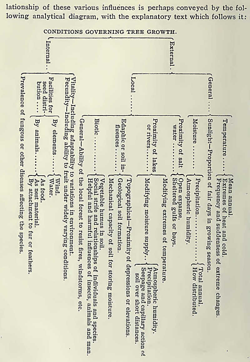
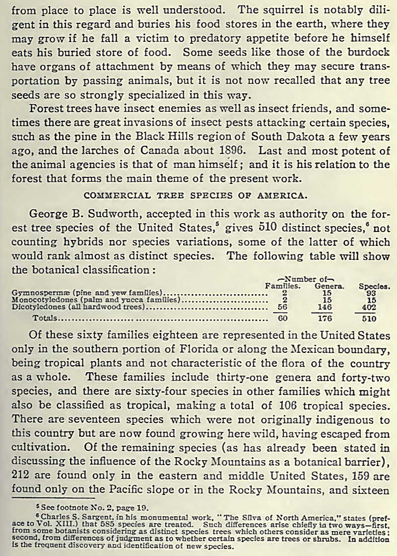
|
Before entering into a
minute discussion of the timber resources and the lumber history of
Canada, it is well to review briefly the North American continent in its
relation to tree distribution, especially with reference to the United
States and Canada, which countries are one in their forest
characteristics. While there is one prominent tree species which is
almost wholly confined to Canada, and a few others whose native habitat
is largely within its area, and while about half of the tree species of
the continent, belonging to the southern United States, do not appear
north of the international boundary, that arbitrary line of demarcation
between the two countries cuts across the mountains, the treeless
plains, the forested areas and the lines of tree growth; so that in a
discussion of tree distribution the two countries should be treated as
one, the differences being determined by soil and climatic conditions
which have no relation to political divisions.
It should be noted
first that the Atlantic Coast, including its islands, is practically all
timbered from the Strait of Belle Isle, or certainly from the northern
boundary of the main body of Newfoundland, to the Strait of Florida. The
treeline follows the Gulf Coast from near the southern point of Florida
to about west of Galveston, Texas, so that the Gulf and Atlantic coasts
of the United States, with small exceptions, are timbered.
As the northern arm of
Newfoundland is practically barren, so is the Labrador Coast. Starting
from the Strait of Belle Isle, the northern forest limit runs a little
inland from the coast, following the boundary between Labrador and
Ungava to Ungava Bay; thence bending westerly and southerly it strikes
Hudson Bay at about 57 degrees north latitude. The northern limit on the
western side of Hudson Bay begins farther north, at about Fort
Churchill, and follows an approximately straight line northwestward,
passing north of Great Slave Lake, to the mouth of the Mackenzie River,
north of the Arctic Circle; thence it turns to the southwest through
Alaska, striking the coast again in the southwestern part of that
American territory.
The Pacific Coast of
North America has characteristics quite different from those of the
Atlantic Coast, owing to the mountain uplift which closely follows the
coast. Instead of a solid and wide body of timber, as is the condition
on the Atlantic Coast, there are smaller areas heavily timbered,
intersected and separated by mountain areas which are nearly or quite
treeless. The presence of the "mountains further results in a semiarid
condition farther inland. Practically all the way from Cook Inlet, in
Alaska, to the Bay of San Francisco, the coast has a continuous fringe
of heavy forest growth, widening out as local topography will permit
into the great forests which are found in British Columbia, Washington
and Oregon.
The western mountain
and plateau country of the continent is more or less timbered
throughout, barren plains being crossed or bounded by forested mountain
slopes, or the barren mountains of the North being penetrated by
tree-lined valleys. This condition obtains, with variations due
principally to latitude, all the way from the Alaskan peninsula to the
Gulf of Tehuantepec.
Between the widespread
and comparatively solid and uniform forests of the East and the broken
and varied forests of the West lies the great, almost treeless, interior
plain of the continent. The boundaries of this treeless plain may be
thus roughly outlined: Starting from Galveston, Texas, the line runs in
an approximately northern direction through the eastern part of Texas
and the western part of Indian Territory. Thence it turns eastward,
crossing the southeastern corner of Kansas, thence across Missouri,
thence bending into Illinois and reaching just beyond the Indiana line.
Thence in a curve it turns to the north and northwest, striking the
Mississippi River in northern Illinois, leaving it in southern
Minnesota, and passes north between Red Lake and the Red River of the
North. Crossing the international boundary in a northerly direction, it
sweeps around Winnipeg to the northwest and strikes about the
northwestern corner of Manitoba. Thence northwesterly and westerly it
crosses Saskatchewan and northern Alberta, and then, turning again to
the southwest and south, follows the line of the Rocky Mountains back
along the western border of Alberta, across Montana, Wyoming, Colorado
and New Mexico, to and across the Mexican border. West of the latter
part of this line is the broken mountain flora previously described.
Within this great
interior plain are trees, but few forests, so that in a general way the
line described surrounds the great agricultural and grazing section of
the continent, the rich agricultural regions east of the prairies having
been won from the forest through more than a century of settlement and
development.
 |