|
“Even where all men
go, none may have stopped; what all men see, none may have observed
James D. Forbes
The fur-trade was now
at its height and, for more than forty years after David Douglas, groups
of travellers continued to cross the Continental Divide by way of
Athabaska Pass. Few indeed are the individuals who were able or took the
trouble to write down their experiences; yet those who did so form a
strangely interesting company—a priest, a soldier, an artist, a
physician, a surveyor. Remarkable it is that the diverse pursuits of
these men should eventually lead them through a common ground; fortunate
that their dissimilar viewpoints were for a little while united in the
interpretation of the wonders of nature. What matter if the
interpretation was often vague and faulty? The wonder of it is that
every man who left a written record of his journey—though his outlook in
other respects differed completely from that of his fellow-travellers—was
spellbound by the natural marvels confronting him.
In April, 1846, the
Jesuit Father, Pierre Jean De Smet—he who first described the geysers of
the Yellowstone—en route to Oregon Missions, crossed the pass westward.
Spending some time in the Athabaska Valley, and being well received by
its inhabitants, he informs us1 that “Lake Jasper, eight miles in
length, is situated at the base of the first great mountain chain. The
fort of the same name, and the second lake, are twenty miles higher, and
in the heart of the mountains. The rivers Violin and Medicine on the
southern side, and the Assiniboine on the northern, must be crossed to
arrive there, and to reach the height of land at the du Committee s
Punch Bowl, we cross the rivers Maligne, Gens de Colets, Miette and Trou,
which we ascended to its source.”
The missionary gives a
sympathetic description of his leave-taking: “As the time approached at
which time I was to leave my children in Christ, they earnestly begged
leave to honor me, before my departure, with a little ceremony to prove
their attachment, and that their children might always remember him who
had first put them in the way of life. Each one discharged his musket in
the direction of the highest mountain, a large rock jutting out in the
form of a sugar-loaf, and with three loud hurrahs gave it my name. This
mountain is more than 14,000 feet high and is covered with perpetual
snow. On the 25th of April, I bade farewell to my kind friend Mr.
Frazer, and his amiable children, who had treated me with every mark of
attention and kindness.”
Roche de Smet is still
a landmark of Jasper Park, but the visitor of today will not recognize
it from the description of the worthy father!
De Smet further
describes his route, and the objects which interested him: “We resumed
our journey the following day and arrived about nightfall on the banks
of the Athabaska, at the spot called the ‘Great Crossing.’ Here we
deviated from the course of that river, and entered the valley de la
Fourche du Trou. As we approached the highlands the snow became much
deeper. On the 1st of May, we reached the great Bature, which has all
the appearance of a lake just drained of its waters. Here we pitched our
tent to await the arrival of people from Columbia, who always pass by
this route on the way to Canada and York Factory. Not far from the place
of our encampment, we found a new object of surprise and admiration. An
immense mountain of pure ice, 1500 feet high, enclosed between two
enormous rocks. So great is the transparency of this beautiful ice, that
we can easily distinguish objects in it to the depth of more than six
feet. One would say, by its appearance, that in some sudden and
extraordinary swell of the river, immense icebergs had been forced
between these rocks, and had there piled themselves on one another, so
as to form this magnificent glacier. What gives some color of
probability to this conjecture is, that on the other side of the
glacier, there is a large lake of considerable elevation.1
From the base of this gigantic iceberg, the river Trou takes its rise.”
All this information De
Smet has been communicating in letters to his friends at home: “You have
learned that I had arrived at the base of the Great Glacier, the source
of the river du Trou, which is a tributary of the Athabaska, or Elk
River. I will now give your reverence the continuation of my arduous and
difficult journey across the main chain of the Rocky Mountains, and down
the Columbia, on my return to my dear brethren in Oregon.
“Towards the evening of
the 6th of May, we discovered, at the distance of about three miles, the
approach of two men on snow-shoes, who soon joined us. They proved to be
the fore-runners of the English Company, which, in the spring of each
year, go from Fort Vancouver to York Factory, situated at the mouth of
the river Nelson, near the fifty-eighth degree north latitude. In the
morning my little train was early ready; we proceeded, and after a march
of eight miles we fell in with the gentlemen of the Hudson’s Bay
Company. The time of our reunion was short, but interesting and joyful.
The great melting of the snow had already begun, and we were obliged to
be on the alert to cross in due time, the now swelling rapids and
rivers.
“The news between
travellers, who meet in the mountains is quickly conveyed to one
another. The leaders of the company were my old friends, Mr. Ermatinger,
of the Honorable Hudson’s Bay Company, and two distinguished officers of
the English army, Captains Ward [Warre] and Vavasseur [Vavasour], whom I
had the honour of entertaining last year at the Great Kalispel Lake.
Capt. Ward is the gentleman who had the kindness to take charge of my
letters for the States and for Europe.
“Fifteen Indians of the
Kettle-Fall tribe accompanied him. Many of them had scaled the mountains
with one hundred and fifty pounds weight upon their backs.”
The gentlemen
encountered by De Smet are worthy of some notice. In 1845, when there
was a possibility of trouble between England and the United States
regarding the Oregon boundary, Capt. Henry J Warre,. and Lieut. M.
Vavasour, R.E., were sent by the British Government on a secret mission
to seek out routes for troops through the Rocky Mountains. Returning,
they left Fort Vancouver on March 26, 1846, travelling via Fort Colville
to Boat Encampment at the Columbia Loop.
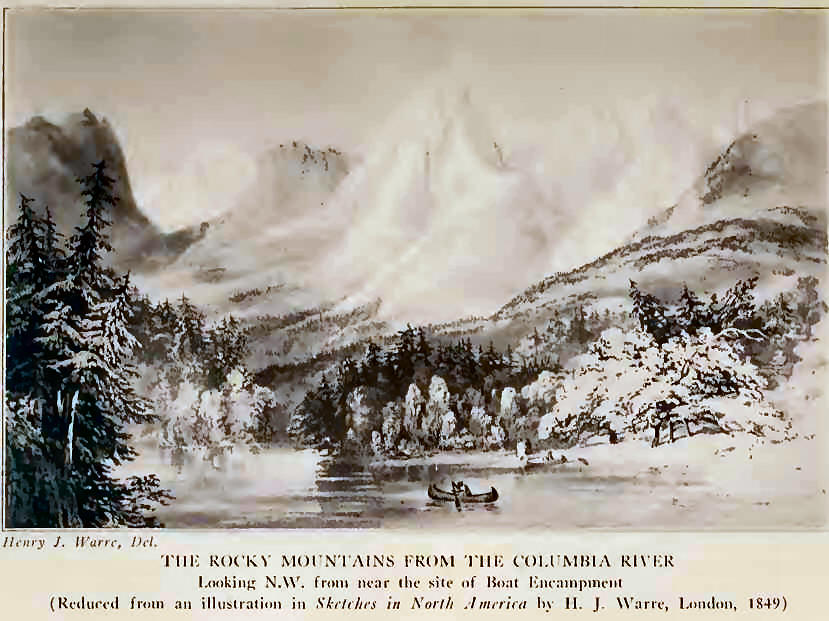
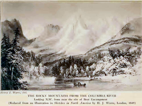
Captain Warre’s account
of the crossing of Athabaska Pass is brief; but he seems to have been
none the less impressed, for he says,2 “We had
for many days been surrounded by magnificent mountains, and had passed
through such a beautiful country, that the effect of this grand and
solitary scene was partially destroyed by the sublimity of that which
had preceded it. The mountains are about 10,000 feet in height,
unequalled in any part of Switzerland for the ruggedness of their peaks
and beauty of form, capped and dazzling in their white mantle of snow.
“On the fourth day we
ascended the ‘Grande Cote’ to the height of land on which are situated
two small lakes, from whence flow two rivers, the waters of which flow
into different oceans—the Columbia into the Pacific, and the Athabaska
into the Frozen Ocean.
“We had scarcely walked
ten miles, when the joyful sound of human voices assured us of more
immediate relief, and we soon encountered a party of men who had been
sent to meet us with provisions, accompanied by Le Pere de Smet, a
jesuit priest from Belgium, and chief of the Roman Catholic missionaries
in the Columbia district, who was on his return to that part of Oregon.”
Captain Warre was a
trained artist: he published his journal, now one of the rarest items in
the literature of the Northwest. The plates accompanying the few pages
of text are exquisitely done, and present the earliest attempt to
illustrate adequately the scenery of the Columbia Valley.
Following De Smet came
the wandering artist, Paul Kane, to whom Governor George Simpson had
granted permission to cross with the Hudson’s Bay Express. Kane’s
purpose was to make portraits and pictures among the various Indian
tribes—a work which he carried into effect.
Of his westward
crossing, in November, 1846, he writes: “We were now close upon the
mountains, and it is scarcely possible to conceive the intense force
with which the wind howled through the gap formed by the perpendicular
rock called ‘Miette’s Rock,’ 1500 feet high, on the one side, and a
lofty mountain on the other. The former derives its appelation from a
French voyageur, who climbed its summit and sat smoking his pipe, with
his legs hanging over the fearful abyss.

“Today we attained what
is called the Height of Land. there is a small lake at this eminence
called the Committee’s Punchbowl; this forms the headwaters of the
branch of the Columbia River on the west side of the mountains, and of
the Athabasca on the east side. It is about three-quarters of a mile in
circumference, and is remarkable as giving rise to two such mighty
rivers; the waters of the one emptying into the Pacific Ocean, and the
other into the Arctic Sea. We encamped on its margin, with difficulty
protecting ourselves from the intense cold.
“The lake being frozen
over to some depth, we walked across it, and shortly after commenced the
descent of the Grande Cote, having been seven days continually
ascending. The descent was so steep, that it took us only one day to get
down to nearly the same level as that of Jasper’s House. The descent was
a work of great difficulty on snow-shoes, particularly for those
carrying loads; their feet frequently slipped from under them, and the
loads rolled down the hill. Some of the men, indeed, adopted the mode of
rolling such loads as would not be injured down before them. On reaching
the bottom, we found eight men waiting, whom M’Gillverey and the guide
had sent on to assist us to Boat Encampment, and we all encamped
together.”
Kane and his party took
ten days between Jasper House and Boat Encampment—fast time for loaded
men under winter conditions of travel. Just a year later, we find the
artist returning homeward over the pass. He took the hardships of the
road without grumbling and not without a certain good-humour: “We
started one hour before daybreak to ascend the stupendous Grand Cote,
and soon found the snow becoming deeper at every step. One of our horses
fell down a declivity of twenty-five to thirty feet with a heavy load on
his back, and, strange to say, neither deranged his load nor hurt
himself. We soon had him on the track again as well as ever, except that
he certainly looked a little bothered. The snow now reached up to the
horses’ sides as we toiled along, and reached the summit just as the sun
sank below the horizon; but we could not stop here, as there was no food
for the horses. We were therefore obliged to push on past the
Committee’s Punch Bowl, a lake I have before described.
“It was intensely cold,
as might be supposed, in this elevated region. Although the sun shone
during the day with intense brilliancy, my long beard became a solid
mass of ice.”
What a picture it must
have made—that lonely procession, passing the frozen summit lake, in the
twilight; the bothered pack-horse (how well-packed he must have been!)
led by an artist-adventurer, burdened, in that pre-Gillette era, with
his frozen whiskers!
But a more modern day
was dawning. The British Government, interested in locating passes and
routes suitable for railroads, sent out an Expedition, under Captain
John Palliser, which remained in the field during the years 1857-60.
Their physician and chief explorer was Dr. Hector, afterward Sir James
Hector, a man renowned among the Indians for the cures he made among
their people; and well remembered for his long and speedy
winter-journeys with dog-teams.
In February, 1859, Dr.
Hector was at Jasper House contemplating a visit to Athabaska Pass. He
mentions4 that Jasper House “is a small post of
the Hudson’s Bay Company which had been abandoned for some years, but
was this winter again occupied and placed under the charge of Mr.
Moberly, who received us most kindly.
“Jasper House is
beautifully situated on an open plain, about six miles in extent, within
the first range of mountains. As the valley makes a bend above and
below, it appears to be completely encircled by mountains, which rise
from 4000 to 5000 feet, with bold craggy outlines; the little group of
buildings which form the ‘fort’ have been constructed, in keeping with
their picturesque situation, after the Swiss style, with overhanging
roofs and trellised porticos. The dwelling-house and two stores form
three sides of a square, and these, with a little detached hut, form the
whole of this remote establishment. The general direction of the valley
of the Athabasca through the mountains seems to be from south to north,
with a very little easting. Four miles below the fort the Athabasca
receives a large tributary from the W. N. W., which is known either as
the Assiniboine or the Snake Indian River. Opposite to the fort, from
the opposite direction, comes Rocky River, and these two streams, with
the Athabasca, define four great mountain masses. Thus, on the east side
of the river there is the Roche Miette, which although really some miles
distant, seems to overhang the fort. Higher up the valley is Roche
Jacques, and on the west side of the valley, and opposite to these two,
we have the Roche de Smet and Roche Ronde. These names were given long
ago to the mountains, at a time when a great number travelled by this
route across the mountains.”
Dr. Hector always
enjoyed a mountain-scramble, for a few days later he notes, “I started
with Moberly to ascend the Roche Miette, and as we had to follow down
the valley for some miles and cross the river, we took the horses with
us so far. I now saw where we had forded the river the other night in
the dark, and it certainly looked an ugly place, and if we had only seen
where we were going, we might have hesitated to attempt it. Having
ridden about six miles from the fort, we left our horses, and commenced
the ascent of the mountain, carrying with us a small pair of snow-shoes,
with which to cross any bad places we might come to; but as we found the
snow was everywhere hard, with a glassy surface that supported our
weight, we soon left them behind. Indeed it was only at intervals that
we required to cross patches of snow, for we followed a ridge or
‘crate,’ as they call it, from which it had been swept by the violent
wind of the last few days. After a long and steep climb, we reached a
sharp peak far above any vegetation, and which, as measured by the
aneroid, is 3500 feet above the valley. The great cubical block which
forms the top of this mountain, still towered above us for 2000 feet,
and is quite inaccessible from this side, and is said to have been only
once ascended from the south side by a hunter named Miette, after whom
it was named.”
On February 10th Dr.
Hector started up the Athabaska, in company with Moberly, the guide
Tekarra, and a Canadian named Arkand. On the following day they reached
a point opposite to Miette’s House where there was once a trading post,
at the point where the track branches up the Caledonian Valley to Fraser
River, from that which leads to Boat Encampment and the Columbia.
Dr. Hector was now on
the present site of Jasper, describing it as follows: “The valley of the
Athabasca, above Miette’s House, is very wide, and is bounded to the
east by a long mountain composed of the earth shales, with only a few
detached masses of the more massive strata capping them. We now
descended to the south, and passed the Campement du roches, where we
found many signs of former travellers, and among others our friend
Hardisty’s5 name, written on a tree last summer
as he returned from the Boat Encampment, where he had been sent to meet
Mr. Dallas. We then reached the Prairie des Vaches, where we encamped,
intending to take our horses no further, as beyond this point there is
little or no pasture at any season, but especially in winter.”
No further progress was
made, because “Tekarra’s foot is so much inflamed with his hunting
exertions, that he will not be able to guide us up the valley to the
Committee’s Punch Bowl, so I changed my plan and followed up the main
stream of the Athabasca instead. At noon we reached the mouth of
Whirlpool River, which is the stream that descends from the Committee’s
Punch Bowl, and I found the latitude 52° 46' 54". Leaving the rest to
follow up the Athabasca, I ascended a mountain opposite to the valley of
Whirlpool River, and had a fine view up it towards the Boat Encampment.
Having been directed by Tekarra, I easily recognized Mount Brown and
Mount Hooker, which are much like the mountains toward the source of the
North Saskatchewan. They seemed distant thirty miles to the south by
west. At night fall we encamped where high rocky banks begin to hem in
the river.
“After following up the
river for ten miles we found it became quite a mountain torrent, hemmed
in by lofty and rugged mountains, two of which, that were very
prominent, I named after my friends, Mr. Christie7 of Edmonton, and
Moberly.”
Then came the later,
final exploring for the railroads. During the summer of 1872, Walter
Moberly, having been ordered to discontinue his survey for the Canadian
Pacific Railroad through Howse Pass, came northward across Athabasca
Pass.
On the Columbia River
he writes,8 “We ran many rapids and portaged others, then came to a lake
which I named ‘Kinbaskit,’ much to the old chief’s delight.”
Moberly did not go all
the way to Boat Encampment, but says that on August 27th, “We resumed
our journey and crossed a high ridge, from which the view was
magnificent, part of the Selkirk Mountains, where we could see hundreds
of snow-capped peaks. We waded the [Wood] River many times, and camped
at the foot of Mount Brown, opposite the old camping ground of the H. B.
Company.
“We now began the steep
ascent by the old H. B. Company’s trail to reach the depression between
Mounts Brown and Hooker—the ‘Athabasca Pass’— gaining an elevated
valley, with grassy glades and groves of firs. Where the walking was
fair we made good headway, and camped a short distance north of the
celebrated ‘Committee’s Punch Bowl.’ Following along, and gradually
ascending Mount Brown, we saw a grizzly bear above us, and shot a
ptarmigan, and then coming on a well-beaten cariboo trail, reached the
top of a ridge, with a high conical peak immediately on our right, and a
mass of hard perpetual snow on the north side of the ridge, down which
we went with difficulty, seeing the fresh tracks of four cariboo. There
was a fine view from the top of this ridge, the mountains in the north
forming a magnificent amphitheatre, some five miles in width, and the
innumerable torrents, dashing down the rocks, with white foam like
silver spray, the thick groves of dark fir, the grassy flats and many
small lakes, or ponds, rendering it enchanting.
“From what I saw of it,
my impression is that there is a pass through from the Canoe to the
Whirlpool River, which at some future time may be utilised, but I cannot
be quite certain of the pass, as my examination was very limited, and,
therefore, imperfect. The stream I followed is the true source of the
Fraser, and I had thus been within a comparatively short time at the
sources of the two large rivers of the Pacific Coast, the Columbia and
the Fraser.”
Moberly later returned
to Kinbasket Lake and assisted in getting the remainder of his outfit to
the site of Henry House, where they wintered. His description6
indicates the difficulties under which the early survey parties labored:
“On the evening of the 1st of October the trail was passable though not
finished, as a great deal of corduroying was needed to the foot of Mount
Hooker, a distance of about twenty miles from the Columbia, and nearly
all the animals on the way between the Boat Encampment and the above
point. On the 2nd I started back for Party T, from the foot of the
mountains, taking Messrs. Green and Hall a part of the way up Mount
Hooker to show them where to open the trail and get the supplies to. My
endeavor now was to get the supplies all to the height of land, the
ascent to which in one place is at an angle of about seventy-five
degrees, so that should I not be able to pack them all the way to the
Athabasca depot, before being stopped by the snow, they would be over
the height of land, and there would be a descending grade along the
Whirlpool and Athabasca rivers over which to convey them on dog-sleds.”
Thus we have followed
the stories of the voyageurs over a period of sixty years, forming a
historic tradition excelled in by no other area of the Canadian Alps.
The narratives are many, scarcely two in exact agreement as to detail,
exaggerated as were the tales of the early European alpine wanderers:
yet all possessing a certain fascination in the evident appeal of
natural phenomena to men unaccustomed to mountain travel, but
nevertheless impressed by the strange wonders of a higher level.
Athabaska Pass was one
of the first trans-continental gateways of North America—the first
through which came any large number of white people. Through it passed
pioneers to whom, in a measure, we owe the foundation of civilization on
the North American Continent. Fortunate are we that something of their
story has been preserved. How utterly strange that their difficult
“Height of Land” should become an alpine playground of today! |