|

(Emerald Lake, the
Blaeberry and the Bow. Traverse of Mount Gordon)
“Snow-draped 'peaks
we passed by, and turquoise lakes set amidst the old pinewoods and
ringed round by gaunt precipices, and above} the snow. Wonderful
waterfalls that plunged sheer for hundreds of feet into rock-cut canyons
where the wild waters raged in fierce tumult. Sometimes the whole
undergrowth amidst the black stems of the burnt forest would be aglow
with the many coloured ‘painter’s brush/ or a mass of gold orange
daisies would have their colour set against the black satin stems of the
charred trunks and a sapphire blue sky. The lure of the wilds always
called us onward ”
J. Norman Collie
Emerald Lake is a Happy
Hunting-ground for the traveller who has not the time or the experience
for wandering far from the railroad. When the train comes down from Lake
Louise, across the Great Divide at the pass of Kicking Horse, and has
puffed through the spiral tunnels, below the peaks of Cathedral and
Stephen,1 with a glimpse of far-flung mountains in Yoho Valley; when you
have come to Field and been driven across the river and through that
glorious arcade of slender jack-pines to the Chalet beside the rippling,
green water, with a shining mountain-range beyond—then only have you
found the threshold of true contentment.
Perhaps as you came
over the Divide, at Kicking Horse summit, you noticed a small monument
at the water-parting. It is dedicated to the memory of Sir James Hector,
physician and explorer with the Palliser Expedition, sent out by the
British Government, in 1857, to explore the country for possible
railroad routes. The pass (5329 feet), was discovered by Dr. Hector in
1858, after he had set out from Bow Fort, crossed the Continental Divide
through Vermilion Pass, and reached the headwaters of the Kootenay.
Thence, he tells us, they traversed a height of land, and descended the
Beaverfoot to its mouth, “a large flat, where the wide valley
terminated, dividing into two branch valleys, one from the northwest and
the other to the southwest. Here we met a large stream, equal in size to
Bow River where we crossed it. The river descends the valley from the
northwest, and, on entering the wide valley of Beaverfoot River, turns
back on its course at a very sharp angle, receives that river as a
tributary, and flows off to the southwest through the other valley.”
Hereabouts occurred an
incident of near-tragedy. Hector goes on to state:1
“One of our pack-horses, to escape the fallen timber, plunged into the
stream, luckily where it formed an eddy, but the banks were so steep
that we had great difficulty in getting him out. In attempting to
recatch my own horse, which had strayed off while we were engaged with
the one in the river, he kicked me in the chest, but I had luckily got
close to him before he struck out, so that I did not get the full force
of the blow. However, it knocked me down and rendered me senseless for
some time. After travelling a mile along the left bank of the river from
the N. W., which because of the accident the men had named Kicking Horse
River, we crossed to the opposite side. We passed many small lakes, and
at last reached a small stream flowing to the east, and were again on
the Saskatchewan slope of the mountains.”
There is another
approach to Emerald Lake, quite as interesting and even more
spectacular. In a short hour one may motor from Field to the charming
bun-galow-camp at Takakkaw, stopping for a moment where the glacial Yoho
River makes a foaming junction with the Kicking Horse. You will know
when camp is near by the roar of water—Takakkaw Fall, coming from the
Daly glacier more than two thousand feet above. Winding and twisting in
an age-worn groove, it makes a little leap toward the brink of the
precipice and drops its plunging volume sheerly for a thousand feet,
arching outward again in a great curve of spray and falling five hundred
feet more to Yoho River. It is the highest waterfall in the Canadian
Rockies, and one may spend hours watching the play of colours on the
brilliant spray—the shimmering rainbows at the river’s edge, that cling
in the rising mist.
From Takakkaw, a
well-kept trail rises to Yoho Pass and leads down again to Emerald Lake
which is spread out below. If the day be still young, it is pleasant to
stroll about on higher levels—the height of Takakkaw becomes apparent,
and its glacial sources are in view. The Yoho Valley is revealed, with
peaks of the Continental Divide beyond—Balfour, Gordon, and all the
rest—mantled in the icefield of the Waputik. Across the basin containing
Emerald Lake, in the west, is the Presidential Range; its rising summits
and glacier-hung cliffs are constantly in view if one follows the trail
toward Burgess Pass. Mount Burgess is the rocky peak so conspicuous from
the lake shore, and flanks the low, wooded saddle which itself is right
above the Kicking Horse and Field village. To reach it, the trail leads
along the cliffs of Mount Wapta and affords splendid distant views into
the south, where rise the mountains of the Ottertail. It will perhaps be
late in the day and the sunset a thing to remember: the sun-flickering
gone from the lake and the green turned to a dull, filmy blue; the
cliffs of Burgess rosy with light; the Presidential Range a silhouette
against an orange sky. In the long shadows of gathering twilight, the
trail leads down to Field or toward the lighted windows of Emerald Lake
Chalet.
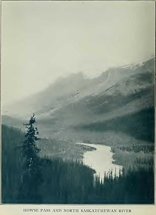
Immediately north of
Kicking Horse Pass, the Waputik Range continues the Continental Divide
to Howse Pass. Only a little of it is seen from Yoho Valley, but, in its
northern portion, the icefields mantling the range have a combined area
of more than forty square miles, draining chiefly to Bow River, a South
Saskatchewan headwater.
We ate our lunch in the
Yoho Valley, Howard Palmer and I, beside the river’s bank at Takakkaw.
It was July 4, 1922, and we walked the Burgess Pass trail back to Field
as a bit of training before leaving for prospective climbs in the
Freshfield Group. It was a calm, warm day, and we were not yet in the
best of condition; still we were down in the village in five hours and
thought well of ourselves.
While the entire body
of snow and ice is more or less continuous, it is arbitrarily divided
into two portions—the Waputik Icefield, extending along the crest of the
continental watershed from Bath Creek to Balfour Glacier; and the Wapta
Icefield, triangular in shape, continuing from Balfour and Yoho Glaciers
to Baker Glacier and other tongues at its northern apex.
At Field, we were
joined by our guide and friend, Edward Feuz, Jr., well known for his
many first-ascents in the Alps of Canada. Two days later found us on the
trail, our pack-train of seventeen horses being under the care of Jim
Simpson, who for more than twenty years has pioneered these mountains.
Bill Baptie was the horse-wrangler, and Tommy Frayne our cook.
Saddington—we never did learn his first name, as he answered always to
the nickname of “Mouse”—a youngster of fifteen, came along to wash
dishes and help keep the straying horses in line.
On the first day we
went only as far as Amiskwi2 River, tributary
to the Kicking Horse, through heavy timber, but on a good trail which
demanded no cutting. It is the beginning of the western approach to
Howse Pass, seldom travelled, but forming one of the few routes which
permit progress close in on the western slope of the main range. For the
most part, the steep British Columbia side with heavy undergrowth,
stimulated by the great precipitation on the western slope, serves as an
efficient barrier to travel with horses. We crossed Emerald and
Kiwetinok Creeks, with bits of steep work in their canyon beds; and from
our campground, in the evening, looked across the river to ridges and
rocky summits of the northern Van Horne Range.
It took us all the next
day to reach Amiskwi, or Baker, Pass. There are heavily timbered
stretches, where one rides for many minutes with no view save patches of
blue sky and slants of sunlight in the tree-tops; then a sharp descent
to a rushing stream: the horses splash through the milky glacial water,
and one catches a glimpse of snow-peaks far up the valley. Northland
trails are ever thrilling, with a prospect that changes constantly. We
gazed up at peaks bordering on Yoho Valley, and at the flying-buttresses
of Mount McArthur, so conspicuous for miles along. The forest is dense;
in places there are windfalls, the tree-trunks piled up and interlaced
like gigantic jackstraws. If they lie across the trail, packs may be
caught or snagged awry, and the axe comes into play. Jim would be off
his horse—he was in the lead—making the chips fly and the woods resound
with the echo of his chopping. The way is soon clear, the horses urged
into line—there is a trail vocabulary especially designed for wayward
cayuses—and the outfit swings along, with sunlight shafting down as
through clouds after a summer storm.
Amiskwi trail parallels
the western wall of the Waputiks; the pass (6535 feet) is not a useful
one for mountaineering as it is scarcely possible to penetrate the range
from this side. In the evening we ascended the high ridge east of the
pass—Ensign Station— whence we obtained a magnificent view of the entire
area. Across the deep valley of Trapper Creek, apparently impassable for
horses, we looked to the summit of Mount Baker (10,441 feet), and to
Mount Ayesha (10,026 feet), with its little blue lake high in a
rock-bowl. Mount Collie (10,315 feet) adjoins it closely and connects
its southern ridge by a glacier-saddle with the peak once named for the
German explorer Habel, but known since the war by the more cumbersome
title of Mount des Poilus. It is possible that climbers might cross to
the Collie-Habel col;5 but cliffs and timber would cause much delay if
horses were taken into Trapper Creek. To the west, we had vistas of
Mount Laussedat (10,035 feet) and the high peaks along Blaeberry River;
while, farther north, the southern walls of the Freshfield Group rose
grandly, tinged with the deep rose and purple shades that precede
twilight.
The descent from
Amiskwi Pass to the Blaeberry is over one of the steepest trails in the
mountains. For a short distance from the pass summit, one zigzags up a
side-hill of open woods whence an impressive view is had of Mount
Mummery, a white giant, rising across the valley into two splendid
peaks, above a curling green glacier cleft by dark morainal lines. Mount
Cairnes (10,120 feet), with its massive ice-crown, stands out
prominently in the southern Fresh-fields. Then comes the down-trail,
steep and muddy, slippery for beast and man, three thousand feet to the
river below. A black bear preceded us, and from his uneven, sprawling
track we concluded that he was in somewhat of a hurry; at least we never
caught up with him and our pace was by no means slow and dignified.
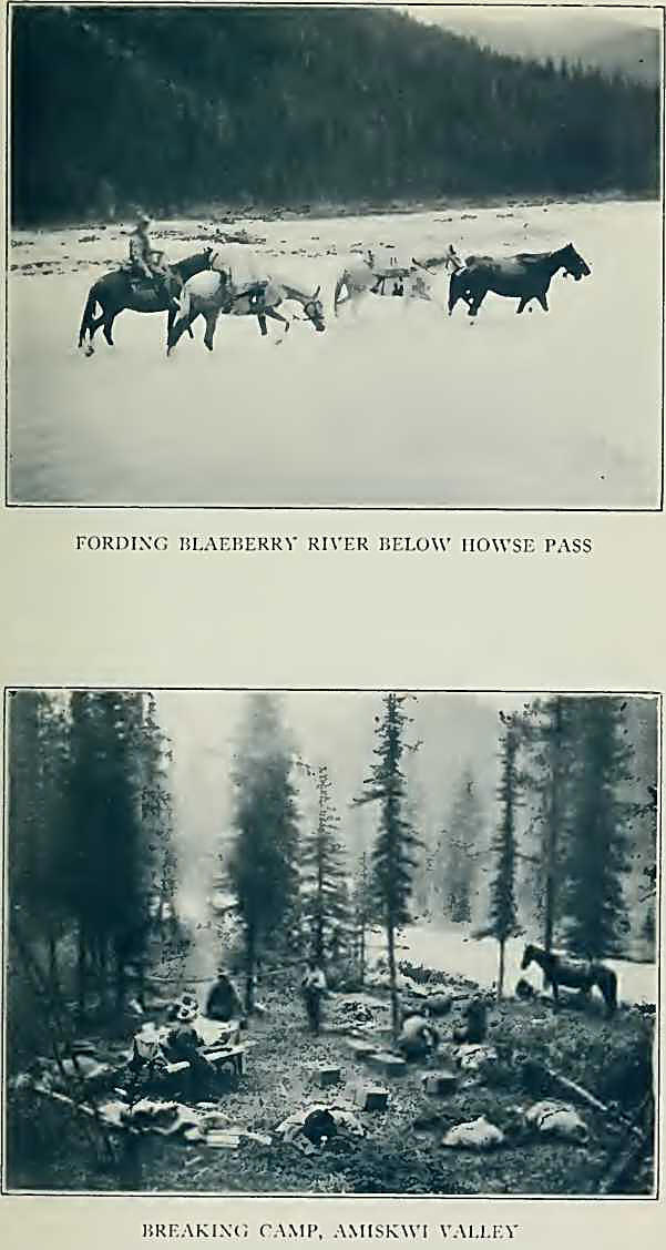
We forded the Blaeberry,
our long procession of horses trailing neck-deep through the water, and
camped in the meadows beyond. All afternoon, a second bear—perhaps a
neighbour of the Amiskwi traveller—wandered about our campground, and we
could see the tips of his ears above the scrub bush as he cautiously
raised up to investigate our presence. One of the boys chased him; he
clambered up to the top of a tall pine and sat disconsolately on a limb,
whimpering.
Our way to Howse Pass3
lay up the Blaeberry Valley, crossing and recrossing the diminishing
stream as we neared the summit. There are sharp little rocky peaks to be
seen at the head of Cairnes Creek, and a waterfall in a canyon farther
along. Much of the trail is washed out by the shifting river; what is
left becomes a tangle of undergrowth and obstructive timber, keeping Jim
out of his saddle and axes flashing. Camp was made below Mount Conway,
in a beautiful meadow not far from the pass summit, and we spent the
afternoon in making a visit to the cirque4
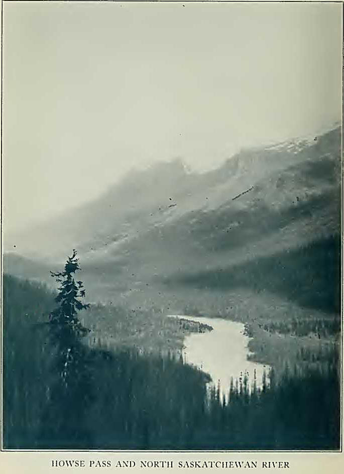
below Conway Glacier. On the very summit of Howse Pass a stop was made
to photograph a fat grey owl, that sat sleepily on the lowest limb of a
fire-killed tree and hissed at us when we reached toward him.
We were just at the
base of Howse Peak (10,800 feet), the highest of the Waputiks, a
serenely beautiful snow peak which had been in view as we came up the
Blaeberry and which flanks the pass on the eastern side. The range of
the Waputiks here diverges from the main watershed, and extends into
Alberta the peaks of Chephren—the western summit usually known as the
“White Pyramid”—Kaufmann, and Sarbach, which fill the Howse-Mistaya
river-angle. From the pass we ascended the timber cutting, marking the
Divide, through the forest for about a mile, and then spent a difficult
hour in the dense bush working out to the basin of Conway Creek above
the deep canyon into wrhich the stream descends. The basin is a large
one, extending into the heart of the Freshfield Group; a precipitous
hanging glacier cascades down from the north face of Conway, while the
main tongue curls over a terminal cliff several hundred feet in height
and sends down slender waterfalls to the cirque in which we stood.
Evening by the
campfire; crystal, with the last rays of sunshine back of the spire of
Mount Forbes. Summer evening is a long twilight, never growing dark, and
on this night a full moon rises, shedding its silvery glory over the
meadow. We can hear the distant jingle of bells as the horses move
slowly through the marsh-grass. The guides tell stories of old explorers
who passed this way in the long-ago; tales so fantastic that if the
shade of David Thompson or of Dr. Hector had walked in to listen, we
should have been unsurprised. If spirits return to haunt the best-loved
places may they not have joined us as invisible guests?
Next day was July 10th,
and we descended the canyon of Conway Creek to its junction with
Freshfield and Forbes Brooks; with many little fords, and fine glimpses
of the snowy Waputiks behind us. We emerged into a spacious amphitheatre
of joining streams, from which flows Howse River. A hotel would have
been here, had original plans matured and the railroad come this way;
but now there are only gravel-flats, with magenta fireweed, and game
tracks crossing and recrossing. South is the entrance to the Freshfield
Group, while westward, the massive outlines of Coronation Mountain, the
green saddle of Bush Pass, and the grim towering peak of Forbes,
complete a delightful and impressive panorama.
We were riding
leisurely along, admiring the beautiful prospect, when suddenly Jim,
ahead of me, began to urge his horse into full gallop. We followed
closely, and on a small gravel-cliff had the unusual experience of
catching a baby goat, that apparently had strayed from home. The little
animal was headed off by a horse on each side and a stream in front.
When several of us approached, the kid gave a frightened leap, fell in
the water and was rescued, kicking and struggling in the arms of Tommy.
It really was only coincidence that the cook should have made the catch,
but the wee beast no doubt expected immediate consignment to the pot. It
was interesting to see that the animal remained limp, as if dead, as
long as it was held tightly; but ready to stiffen like a steel spring
and bolt if the chance offered. We soon released it, and in our last
glimpse it was proceeding with all speed, but with a damp and injured
air, down the Saskatchewan gravel-bars.
As the Freshfield
Group, where we spent the days following, is described later,8 we shall
here continue on the Waputik trails. It was July 21st when we descended
Howse River to a point below the Glacier Lake stream. Alpine flora gives
the river-flats a gay appearance and game tracks are everywhere —moose,
bear, deer, and goat trails winding back and forth. Every evening we had
watched, through binoculars, the big billy-goats come out to feed on the
high alpland above the cliffs. And once, as we came late into camp, a
cow moose with her calf plunged back into the timber.
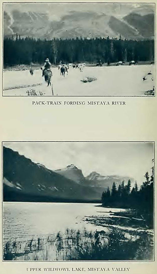
Since crossing the
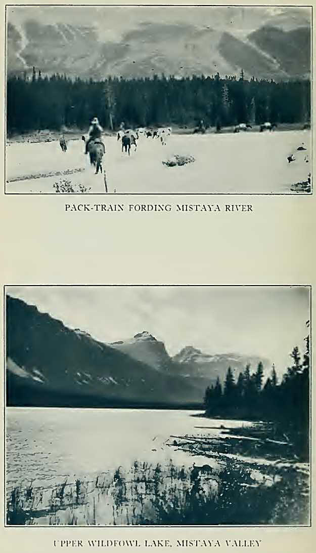
Divide, at Howse Pass, we were again in Alberta. Next morning, rounding
the base of Mount Sarbach, we reached Mistaya5
River not far from the main Forks of the North Saskatchewan. It was a
chilly day, with fog and showers, one of the few on which we travelled
in the rain. A trail on the west bank of the stream avoids the old
difficult fords, and, at evening, camp was made at the base of Chephren.
Clearing weather cheered us, and we fairly revelled in the gorgeous
spectacle presented by the Kaufmann Peaks and the towers of Murchison,
all agleam with new snow, sparkling above the violet-tinted cliffs of a
shadowed valley.
The headwaters of the
North Saskatchewan— North Fork and Mistaya Rivers—parallel the
Continental Divide, in a broad, heavily-forested trench which continues,
across Bow Pass, to the upper Bow Valley, a South Saskatchewan
tributary. Perhaps nowhere else in the world can be found such a number
of large and beautiful lakes as those which are found here, directly
below the escarpment of a great mountain chain. Close to camp, the
Wildfowl Lakes reflect the rocky pinnacles that rise on the eastern side
of the Mistaya, and which give way to slightly lower and more separated
summits which buttress Bow Pass. Howse Peak and the Waputiks form a
stupendous, unbroken wall on the west. Trail to Bow Lake was followed on
the next day; a trail of gradual rise, with undulant, pine-crested
hillocks, whence one obtains glimpses into sequestered nooks, corners of
sapphire lakes, and occasionally, northward, the expanse of one of the
most extensive valley views of the Rockies— from Bow sources to peaks
near Nigel Pass and Bra-zeau headwaters. There are a few gaps in the
Waputik wall, through which we could see distant snowy peaks, beyond the
precipices of Mount Patterson (10,490 feet) with their slender,
interlocking icefalls.6 From the summit of Bow
Pass it is but a short walk to a rocky bluff above the ultramarine
expanse of Peyto Lake, with a view of the glacier and its ice-arch; one
follows the course of Mistaya River to the Saskatchewan Forks—spread out
like a map—with the snows of Mount Wilson visible beyond.
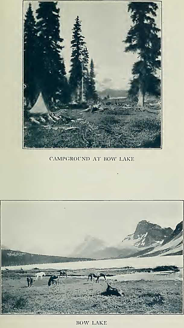
Bow Lake is the most
pleasant of camping places. Our tents were in a grove of old trees near
the water’s edge, where white-tailed deer came down to drink, heedless
of our presence. Just opposite, Bow icefall cascades downward through
the gap between Portal and St. Nicholas Peaks, the broken ice-snout
coming almost to the lake. Trout abound in the lake, big Dolly Varden,
but the larger ones always ruined our primitive tackle: a splash, a bit
of line flicking skyward on the end of a green pole, a man sitting down
with unexpected suddenness, and language usually reserved for private
conversation with the horses! Across the lake a wall of cliff, beginning
at Bow Peak, supports the Crowfoot Glacier; and, through a gap farther
east, the snow slopes of Mount Hector rise to a sharp peak.
The distance from Bow
Lake to the railroad, twenty-six miles, is broken by a camp on Hector
slide, north of which looms the jagged ridge of towers making up
Dolomite Peak. Down the valley one sees the peacock-blue water of Hector
Lake, and the delta made by the entering streams from the glaciers of
Balfour. And finally, through a rift in the clouds, the groups above
Lake Louise burst into view, Mount Temple and the Victoria ridge rising
above all the rest. The home-corral is near; the cayuses sense it, and
shy skittishly as the long-drawn whistle of a locomotive is heard far
down the valley.
From Bow Lake a year
later, in 1923, we reached rail by a decided variant of this route and
succeeded in annexing one more adventure of the Waputik trail. We had
come back from the Columbia Icefield, Dr. Ladd, Conrad Kain, and I, and
wished to avoid a repetition of the final day’s ride. So, deciding to
penetrate the mountain group and climb across to Takakkaw, we left the
horses, on July 24th, Simpson taking the pack-train by trail to Lake
Louise.
In an hour we had
rounded the lake to the gloomy canyon below the Bow icefall. So narrow
is the stream-cut gorge that not far from the glacier a single gigantic
stone forms a bridge, on which one may sit and look down into the
roaring cauldron of water below. Ascending the rocky ledges beside the
ice, we quickly gained height and eventually were able to cut our way
across the top of the fall to the Wapta neve.11 It presents a broad
expanse, somewhat crevassed, with long-ridged peaks rising from the
snow. Across the long slopes behind St. Nicholas and Olive we tramped,
to Vulture Col—its curious summit blocks suggesting an enormous bird
rising from a nest—and thence up the smooth, slanted slabs to the summit
of Mount Gordon.12 The weather was cloudless, but in the soft snow we
had taken nearly eight hours from our lake camp. From our elevation of
10,336 feet, we again paid our respects to old friends in the north,
from Freshfield to Columbia. Across the Balfour Glaciers we looked down
to Hector Lake, with cloud shadows moving lazily across; to the
Ottertail Group, and the peaks of Yoho.
We entertained the
audacious idea of going on to ascend Balfour, and actually started for
it; but a rumble of thunder, when we had glissaded to Balfour Pass,
warned us that we had accomplished enough for one day. Leaving Diableret
Glacier we ran down past
two lovely waterfalls
at the head of Waves Creek, the lower fall foaming and spraying through
a series of basins worn in the sandstone. We were not to go free. A
violent electric storm, with pelting hail, overtook us. The retreat of
Yoho Glacier makes it impossible to cross the ice-snout as in former
years. We made vain attempts to ford Yoho River; even when roped
together, the current was too swift for us. Conrad went clear under, and
came up looking like an alpine Neptune arising from the deep—still
holding his pipe between his teeth!
Finally we crossed the
canyon, lower down, making the passage roped, over a slanted log, with
serious damage to soaked clothing. Water rose and bridges went out. The
stream from Twin Falls, although one of the twins gave up the ghost some
years ago, was a raging torrent. We built a rickety structure from logs
and got over somehow; then wandered through the drenched brush to find
the trail, and finally arrived at Takakkaw as daylight was fading. A
last flash of lightning and a peal of thunder, resounding toward Little
Yoho, was as if Jupiter Pluvius and the witches of the Trolltinder were
having a final laugh at us. But we had defied these evil spirits and had
attained to knowledge of the fairy-like splendor of the Waputik. |