THE French profess the
right by Treaty, of catching and drying fish from Cape Ray on the west
through the Straits of Belle Isle as far as Cape St. John northward,
though they are not allowed to make any fortifications, or any permanent
erections, nor are they permitted to remain longer than the time
necessaiy to cure their fish. This line of coast is as follows :—
The whole line of shore
in exclusive use of Great Britain, is 535 geographical miles. The number
of inhabit tants on the west coast is about 2,300,principally Acadians,
descendants of the French, from Nova Scotia and the Island of Cape
Breton, interspersed with English, Irish, Scotch and Canadians. The
coast is fast settling. Hitherto the Government of Newfoundland has
exercised no control over the inhabitants of this part of the country,
and of course they have not been represented in the Legislature. In
1849, the Government appointed a gentleman in the two-fold capacity of
Stipendiary Magistrate and Collector of Customs to reside at St.
George’s Bay, but after a short residence there he removed.
The principal places on
the West-Coast are Cod-Bay, St. Caspars Bay, River Humber, Bonne Bay,
and Port-au-Port, St. George’s Bay and the Bay of Islands, are
geologically interesting. All who have ever visited this part of the
country, describe its scenery as exceedingly interesting and beautiful.
It has all the elements of future greatness. Here is a coal field thirty
miles long and ten broad, situated only eight miles from the sea, and
twenty miles from St. George’s Harbour, supposed to be a continuation of
the coal mines of Cape Breton. There is also marble of almost every
variety and colour, some masses of which are five hundred feet in
height. There are also soft sandstones, flagstones, gypsum, &c. Had this
part of the country been settled first, instead of the eastern portion,
it would now have a population of some hundreds of thousands. In this
portion of the country there are all the elements to set in motion
agriculture, manufactories, steam, vessels, railroads, and architecture.
The amount of salt
annually imported into Newfoundland is about 900,000 bushels, which is
mostly consumed by the fisheries. It was never manufactured in
Newfoundland until 1850, when Mr. John H. Warren commenced to
manufacture it on a small scale, at St. John’s, from sea water, but
discontinued it. There are several salt springs at St. George’s Bay, the
brine of which, if manufactured, would probably afford sufficient salt
for the convenience of the country. The geological formations where
these springs exist are identical with those of England, Spain, and the
United States.
The quantity of coals
imported into Newfoundland in 1875 was 27,034 tons, principally from
Cape Breton. The produce of the Pictou coal mines in 1855 was 820 tons,
valued at £47,699 or $190,796. And of the Sydney mines, 26,877 chaldrons,
valued at £20,274 or $82,000. From Nova Scotia, 50,785 chaldrons were
exported to the United States from Cape Breton, 10,125 were sent to Nova
Scotia, 6,617 to other British colonies, and 10,942 to the United
States. The importance of the coal fields of St. George’s Bay is very
apparent, when we consider its proximity to Canada East, where no coal
is found, and wood fuel is rapidly disappearing. Firewood is also
rapidly becoming very scarce along the sea board of the eastern shores
of Newfoundland, where there is a population of 160,000. The following
are the observations of 0. J. Brydges, Esq., Managing Director of the
Grand Trunk Railway of Canada, in li566 :—
“Whilst I was in Nova
Scotia I visited Pictou and the coal districts in its vicinity. The
present railway system of Nova Scotia consists of the railway system
from Halifax to Truro, with a branch to Windsor, at the head of Minas
Bay. The Nova Scotia Government are now constructing, as a Government
work, an extension of the railway from Truro to Pictou, which will be
completed in about a year from this time. This railway runs through the.
coal district. There are two principal coal mining companies now at
work—one, the General Mining Association, has been in operation for a
considerable, time, and has at present three mines in actual operation,
and one more which they are opening out. The shafts of these mines vary
from 200 to 600 feet in depth. The seam of coal which is being worked is
40 feet in thickness, of which about 36 feet is solid coal. In these
three mines there are at present employed between 800 and 1000 men and
boys. The average pay of the colliers during the last year having been
about 9s. 4½d. currency a day; ordinary labourers getting from 4s. to a
dollar. The mines are being worked very extensively with steam-engines
and all proper appliances. The General Mining Association have a rail
way about seven miles in length, which has been in operation for upwards
of twenty years. The gauge of this railway is four feet eight and a half
inches, and they have upon it six engines and five hundred and seventy
trucks. These trucks are loaded with the coal at the mouth of the pits,
and are taken to a point on the river where ships of the largest size
can come alongside the wharf. The quantity of coal which has been
shipped by the Mining Association for some years past has amounted to
about 200,000 tons annually. The price of the steam coal at the point of
shipment is about $2.50 per ton, and of small coal about $1.50 per ton.
“Freight from Pictou to
Boston would range from $2.50 to $3 a ton, the same rates, or
thereabouts, being charged to Montreal. This company owns four square
miles of coal land, and they have also, in the vicinity, land containing
very large quantities of iron ore, as well as lime.
“The other mining
company, which has lately be started, is called the Acadian Mining
Company. They have one seam six feet thick now opened, out of which they
are getting coal, and they have just opened another seam which they will
begin immediately to work, and which has a thickness of 20 feet. They
own a very large property in the neighbourhood of New Glasgow. They are
about to make three miles of railway, to connect their shafts with the
railway now being constructed from Truro to Pictou. The quantity of coal
appears to be inexhaustible, and there seems to be no reason why this
coal, which is of excellent quality for steam purposes, should not be
delivered in Montreal for five dollars a ton. I was so satisfied with
the excellent quality of this coal, from the reports I heard of it, that
I ordered several cargoes to be sent to Montreal for the use of the
Grand Trunk Company, so as to have it thoroughly tested for our
purposes. There can be no doubt that the coal which exists in Nova
Scotia, in the neighbourhood of Pictou, and also at Cape Breton, where
large mining operations are going on, will prove, when proper means of
communication are supplied, to be of great importance in the future
history of the Confederacy.”
Professor Sedgwick, of
the University of Cambridge, recommended J. B. Jukes, a graduate of that
university, a member of the Geological Society of England, and
afterwards a professor of Geology in Trinity College, Dublin, and author
of several works, as a competent person to make a geological survey of
Newfoundland. Mr. Jukes was accordingly employed by the Local Government
for two years, 1838 and 1839. He was but poorly provided however for
making the survey, he had no geological probe, and few instruments for
boring, &c. Mr. Jukes merely made a partial survey of the sea coast, aud
went nowhere into the interior, except a line from Bay of Exploits to
St. George’s Bay. His Geological Report, however, laid before the
Legislature, is exceedingly interesting, and gives more information
respecting the geological structure of the Island than was ever known
before. Respecting the coal formation of St. George’s Bay, Mr. Jukes
says:
“This interesting and
important group of rocks resembles in its higher portions the coal
formation of Europe, and consists of alternations of shale and clunch, w
ith various beds of gritstone and here and there a bed of coal.
Interstratified with those rocks, however, there occur in Newfoundland
beds of red marl; and as we descend to the lower parts of the formation,
there come in alternations of red and variegated marls with gypsum, dark
blue clays with selenite, dark brown conglomerate beds, and soft red and
white sandstones. This inferior portion of the Newfoundland coal
formation so greatly resembles the new red standstone of England (which
in that country lies over the coal formation), that it was not till I
got the clearest evidence of the contrary that I could divest myself of
the prepossession of its being superior to the coal in this country
also. That nothing might be wanting to complete the resemblance, a brine
spring is known to rise in one spot on the south side of St. George’s
Bay, through the beds of red marl and sandstone. It is certain- however,
that in Newfoundland the beds containing are above these red marls and
sandstones, with gypsum and salt springs, the whole composing but one
formation, which it is impossible to subdivide by any but the most
arbitrary line of separation. The total thickness of this formation must
be very considerable. I by no means have any reason to suppose that I
have as yet seen its highest beds, while the thickness of those which I
have seen must amount altogether to at least one or two thousand feet.
“The Humber
Limestone.—This group of rocks lies below the Port au Port shales and
gritstones, and in the Bay of Islands it is the one next inferior; as
however their junction was not exposed, I cannot say whether the one
graduates into the other, or whether other beds may not be interposed
between the two in other localities. The highest part of the Humber
Limestone which was visible, was a thin bedded mass, about 30 feet
thick, of a hard, slaty limestone of a dark grey colour, with brown
concretions that, on a surface which had been sometime exposed, stood
out in relief. Below this are some thin beds of hard subscrystalline
limestone, the colours of which are white or flesh-coloured with white
veins. These would take a good polish, and would make very ornamental
marbles, and from the thinness of the beds are especially adapted for
marble slabs. This series of beds has a thickness of about 200 feet.
Below these are a few feet of similar beds of black marble, which rest
on some grey compact limestone, with bands or thin beds and irregular
nodules of white chert; and these latter beds pass down in a large mass
of similar limestone, without chert, and in very thick beds. This mass
of rock forms hills four or five hundred feet high, in nearly horizontal
beds. Its upper part continues to be regularly bedded, but in its lower
portion all distinction into beds is lost, and the limestone becomes
perfectly white and saccharine. This great mass of white marble is
frequently crossed by grey veins, so that I cannot say that I saw any
block pure enough for the statuary. There is little doubt, however, that
in so large a quantity, some portions might be discovered fit for
statuary marble, and for all other purposes to which marble is applied,
the store is inexhaustible.
"The hills about the
head of St. George’s Bay, though rarely exceeding one thousand feet in
height, are of a mountainous character, rugged and precipitous; and this
continues to be the nature of rather a wide band of country, that runs
from the east of St. George’s Bay across the Humber River, at the head
of the Bay of Islands, and thence for a considerable distance still
farther north. About St. George’s Bay this ridge of hills forms the
water-shed of the country ; the brooks on one side running down into the
Bay—those on the other emptying themselves into the Grand Pond, a large
lake in the interior. This lake commences at about fifteen miles in a
straight line N.E. from the extreme point of St. George’s Bay. In the
first seven miles the lake spreads out to a width of about two miles,
and runs about E. S. E. ; at this point, however, it bends round,
divides into two branches, each from half a mile to a mile wide, which
enclose an island about twenty-one miles long and five across in the
broadest part. In this part of its course the direction of the lake is
E. N. E. The remainder of the lake, which is about twenty-live miles
long and four or five across, gradually tends round to the N. E. and N.
E. by N. The whole length of the lake is about fifty-four miles. At its
S. W. extremity it is enclosed by lofty hills with precipitous banks,
and is of great depth, no bottom having been found with three fishing
lines, or about ninety fathoms. Its depth is further proved by the fact,
of the truth of which my Indian guide assured me, that its S.W. half is
never frozen over in the hardest winters. Towards its N. E. end it
gradually becomes shallow, and the hills slope down into a flat country
which extends, as far as the eye can reach, towards the N. and N. E. The
lake receives on all sides many brooks, and at its N. E. extremity a
very considerable river, fifty yards wide and several feet deep, comes
in, which is called the Main Brook. Three miles W. of the mouth of this
river, an equally considerable one runs out of the pond; this latter is
full of rapids for five or six miles, when it is joined by another river
of about the same size, which flows from the North-West. These united
rivers run towards the S W. and in about six miles enter Deer Pond, a
lake about 15 miles long and 3 or 4 across, running in a direction about
N. E. and S. W. The S. W. end of this lake is again encircled by the
hills, through which the united waters force their way by a narrow and
precipitous valley, forming the River Humber, and running out into the
Bay of Islands. The part of the river between Deer Pond and the sea is
about twelve miles long, from about 50 to 100 yards across, and several
feet deep ; its navigation is, however, impeded by two rapids, one about
three miles from its mouth and three quarters of a mile long, and
another, shorter but steeper and more dangerous, about half a mile below
Deer Pond. The river which, above Deer Pond, comes in from the north and
joins that running out of the Grand Pond, is likewise encumbered with
rapids, our progress up each branch being stopped half a mile from their
junction by rapids utterly impracticable with our boat. I afterwards
interrogated the Indians respecting the course of the river in those
parts into which I was not able to penetrate myself, and they informed
that the north branch, which I shall call the Humber, rises in the
country near Cow Head, passes down to the east through several lakes,
two of which are 8 or 10 miles long, and gradually bends round to the S.
or S. W., to the spot I have before described. The main brook which runs
into the N. E. end of the Grand Pond, is navigable for a canoe for a
distance of some miles above the place where I turned back. It is there
found to run out of a lake 8 miles long; on the other side of the lake
the river is again met with, and passing up it three more lakes are
crossed, each above six miles long. The extremity of the last of these
is about 18 miles from Hall’s Bay, a branch of the Bay of Notre Dame ;
and crossing half a mile of land another brook is met with, down which a
canoe can proceed to the waters of that Bay. It thus appears that the
country drained by the Humber is upwards of one hundred miles from N. to
S., and fifty or sixty from E. to W., by far the most extensive system
of drainage in the Island ; it approaches the sea on three points,
namely, Cow Head, Hall’s Bay, and St. George’s Bay, and the united
waters force their way out at a point nearly equidistant from each,
having either formed for themselves or taken advantage of the narrow
pass between Deer Pond and the South branch of the Bay of Islands,
called Humber Sound. The Indians likewise informed me that if they
proceeded from the east side of the Grand Pond, opposite the east end of
the Island, a day’s journey to the east brought them to the South end of
Red Indian Pond, a lake between forty and fifty miles in length, and
from that point another day’s march to the South-east brought them to
the middle of another large pond of about the same size. Each of these
ponds empties itself by a brook into the Bay of Exploits. They each run
about in a parallel direction with the Grand Pone, or about N. E. and S.
W., and the S. W. end of the third large pond is within a long day’s
walk of White Bear Bay. It thus appears that there are two easy methods
of crossing the the country from north to south with a canoe. The first
by proceeding from St. George’s Bay, through the Grand Pond to Hall’s
Bay ; the second from White Bear Bay, through the third pond to the Bay
of Exploits.
“In the cliffs near
Codroy Island is much red and green marl, with bands of white flagstone.
The white flagstone and the greenish marl contain many veins of white
fibrous gypsum, and interstratified with these and the red marls are
some thick beds of white and grey gypsum, of a singular character. These
P gypsum beds are not hard, compact sulphate of lime, but are composed
of white flakes of that substance, regularly laminated, and interspersed
with small flakes and specks, or sometimes thin partings of a black
substance, apparently bituminous shale. The whole mass is soft and
powdery, thick bedded, and in considerable abundance, and it might be
carried away in boats with great facility.
“I was informed by some
Indians of Great Codroy River that they had seen a bed of coal two feet
thick, and of a considerable extent, some distance up the country. Their
account of the distance, however, varied from ten to thirty miles ; and
I could not induce any of them to guide me to the spot. I proceeded up
the river abont twelve miles from the sea, and some distance beyond the
part navigable for a boat, without seeing anything but beds of brown
sandstone and conglomerate, interstratified with red marls and
sandstones, gradually becoming more horizontal and dipping towards the
S.E. I believe, however, that a bed of coal had been seen by an Indian
on the bank of a brook running into Codroy River, about thirty miles
from its mouth, but that the person who saw it was not in the
neighbourhood at the time of my visit.
About the middle of the
south side of St. George’s Bay, in the vicinity of Orabb’s River, the
lower part of the coal formation, consisting of alternations of red marl
and sandstone, strikes along the coast, the beds dipping to the N\\V. at
an angle sometimes of 45 degrees. About three miles from tho coast,
however, ananticlinal line occurs, preserving the same strike as the
beds, or about N.E. and S.W., and causing those to the south of it to
dip to the S.E. Thus the rocks which form the country along the coast,
to the width of three miles, with a New. dip, again occur to the same or
a greater width, according to the angle of their inclination, with a dip
to the S.E. before we can expect to find any higher beds than those in
the sea cliffs ; so that at least six miles of country formed of the
lower beds must be crossed directly from the coast, before we arrive at
the higher beds in which the coal is situated.
“In ascending the brook
next above Crabb’s River I found on tho sea coast beds of soft red
sandstone and red marl, and, half a mile up the brook, red and whitish
sandstones, interstratified with beds of marl, chiefly red, but also
occasionally whitish, green, or blue; beyond that were beds of marl,
containing massive grey gypsum, similar to that at Codroy, and a bed of
blue clay, containing crystals of selenite. Similar rocks, with now and
then a bed of brown or yellow sandstone, occurred throughout the first
two or three miles, all dipping N.W. at various angles of inclination.
Beyond this point the dip was invariably S. or S.E., and for two or
three miles further the character of the rocks was precisely similar to
those I had already passed. As, however, the banks of the brook were
occasionally low, the section observed was of course not perfectly
continuous, and beds which were hidden on one side of the anticlinal
line, formed cliffs, and were thus exhibited on the other side. Thus, as
I continued to ascend the brook, I came on a cliff of red marl, fifty
feet thick, with some thin grey soft micaceous sandstone, beyond which
were some beds of grey hardish rock, with nodules of sub-crystalline
limestone, the banks of the river being likewise covered with a crust, a
foot thick, of tufa. Some distance above this the red sandstones become
more scarce, the colour being generally brown or yellowish; grey clunch,
too, with bituminous laminae, was frequent.
“In one bank of brown
sandstone, a nest of coal with a sandstone nucleus was seen. The shape
was irregular and was about two feet long. It most probably was a
vegetable remain squeezed out of all semblance of its former shape. Over
this mass of sandstone there was again a good thickness of grey clunch,
and brown or yellow sandstone and conglomerate interstratified with red
and brown marl, all dipping gently to the S.E. Over these were some thin
beds of red sandstone with red marl, and a little beyond some hard light
brown or greyish yellow sandstone with small quartz pebbles. This rock
formed ledges stretching across the river, producing a fall of two or
three feet.
“About one hundred and
fifty yards above this, on the west bank of the brook, was some grey
clunch and shale, on which rested a bed of hard grey sandstone, eight
feet thick, covered by two or three feet of clunch and ironstone balls,
and two feet of soft brown sandstone, with ferruginous stains, on which
reposed a bed of coal three feet thick. The dip of these rocks was very
slight towards the south, in which direction the bank became low, as it
was also on the opposite side of the river, which prevented my tracing
the coal further ; neither was the bank above the coal high enough to
bring in any of the beds over it and thus give its total thickness,
since it is evident the position here seen may be only the lower part of
a bed instead of the whole. The quality of the portion thus exposed was
good, being a bright caking coal. The distance from the sea shore is
about eight miles j the only harbour, however, is that of St. George,
which is about twenty miles from this spot. A few very rude and
imperfect vegetable impressions were all I could see in any of these
rooks. Many of the gritstones in this section might turn out good
freestones. In the next brook to the east of the one I ascended, was
formerly a salt spring, which, however, I was assured, had lately become
quite dry ; but several of the little rills which I tasted in the
neighbourhood were brackish. As regards the extent of country occupied
by this bed of coal, or others which may lie above it, the data on which
to found any calculation are but few. If, however, the upper rocks
follow the course of the lower, without the intervention of faults and
irregularities, the tract so occupied would probably be an oval, forming
the centre of the country, bounded by the sea coast on the north and the
ridge of primary hills on the south. From the top of the highland at
Crabb's River, this ridge bounded the horizon at the distance apparently
of about twenty miles. Allowing half of this width to be occupied by the
lower beds, the tract yielding coal would probably be twenty or thirty
miles long by ten miles wide. Gypsum again appears once or twice in the
cliff between Crabb’s River and St. George’s Harbour. The north side of
St. George’s Bay, between Cape St. George and Indian Head, is occupied
entirely by beds of the magnesian limestone mentioned before, all
dipping at a slight angle to the N.N.W-, and thus passing under the
great mass of shales and gritstones which forms the country about Port
au Port.
“As regards the
external character of the district now under consideration, I have
already spoken of its physical geography, and have only to add a few
words on its agricultural capabilities. The coal formation, on account
of its alternate beds of marl and sandstone, and its low and undulating
surface, is everywhere admirably adapted for cultivation. On the south
side of St. George’s Bay, along the sea cliffs, on the hanks of the
rivers, or wherever the surface is drained and cleared of trees, it is
covered with beautiful grass ; and the few straggling settlers scattered
along that shore exist almost entirely on the produce of their live
stock. The aspect of their houses put me in mind of the cottages of
small farmers in some parts of England. There is every reason to believe
that the same fertility would be characteristic of the country round the
N. E. of the Grand Pond. The whole of the district, even the primary
hills, is covered with wood of a far finer description than the
generality of that on the east side of the island. Groves of tine birch
and juniper are scattered among the fir, and pines are met with here and
there in the interior of the country. On the bank of a brook between St.
George’s Bay and the Grand Pond, my Indian guide pointed out several
fine ash trees. The Bay of Islands, has, I believe, long been celebrated
in Newfoundland tor its timber ; and I can safely assert, that the Banks
of the Humber, as far as I ascended it, did not deteriorate in that
respect—every portion of the country being densely covered with fine
wood.”
Alexander Murray, Esq.,
in his Report of the Geological Survey of Newfoundland, in 1866 and
1867, says :—
“The coal formation is
probably the most recent group of rocks exhibited in Newfoundland
(excepting always the superficial deposits of very modern date, which
are largely made up of the ruins), and there may have been a time in the
earth’s history when it spread over the greater part of the land which
now forms the Island ; but a vast denudation has swept away much of the
original accumulation, and left the remainder in detached patches,
filling up the hollows and valleys among the harder and more endurable
rocks of older date, on which it was unconformably deposited. One of the
most important of these detached troughs or basins of coal measures is
in Bay St. George, where the formation occupies nearly all the lower and
more level tract of country between the mountains and the shores of the
Bay ; and another lies in a somewhat elongated basin from between the
more northern ends of the Grand and Deer Ponds, and White Bay; the
eastern outcrop running through Sandy Pond, while the western side
probably comes out in the valley of the Humber River, near the eastern
flank of the long range of mountains. There is reason also to suspect
the presence of a smaller trough of the same rocks, between Port-a-Port
and Bear Heail towards the Bay of Islands, the greater part of which,
however, is probably in the sea ; and from local information I received
from the Indians, as well as some residents at the Bay St. George, I th'
ik it not improbable that another trough of the formation may occur in
the region of the Bay of Islands.”
Captain Loch in his
report to the Vice Admiral, the Right Honourable the Earl of Dundonald,
in 1849, speaking of St. George’s Bay, says :—
“There are two hundred
resident planters in this Bay, who receive assistance in hands during
the fishing season from Cape Breton and its adjacent shores. Their
fishing usually commences a month or six weeks earlier than that on the
coast of Labrador. This year they began the 27th April. They fish
herring, salmon, trout, and eel, besides the cod. Up to the present date
(17th August) the catch has been 10,000 barrels of herring, 200 barrels
of salmon, and but a small quantity of cod. They employ about 200 boats
and 800 hands, and send their fish to the Halifax and Quebec markets
during the summer and fall. The fishings end about the 1st of October,
with the exception of the eels, which are caught in great quantities and
afford subsistence during the winter. They have bait without
intermission during the entire fishing, and use caplin, herring, squid,
and clams. The climate is usually dry and mild, and if their society was
under proper control, St. George's Bay would offer many inducements to
the industrious settler. The harbour is occasionally blocked up by ice,
but for no length of time, and is always open by the middle of April.
The inhabitants consist of English, a few Irish, and a number of lawless
adventurers—the very outcasts of society from Cape Breton and Canada;
and it is very distressing to perceive a community, comprising nearly
1000 inhabitants, settled in an English colony under no law or
restraint, and having no one to control them, if we except what may be
exercised through the influence shown by the single clergymen of the
Established Church, who is the only person of authority in the
settlement. I am told the reason why magistrates are not appointed, is
'n obedience to direct orders from the home government—it being believed
against the spirit of the treaty with France. Under these circumstances
I would recommend, either that a vessel-of-war should be appointed to
remain stationary in the harbour, or that the society should be forcibly
broken up and removed, for violent and lawless characters are rapidly
increasing, and neither the lives nor property of any substantial or
well-disposed settler are safe. Four cases of violent assault were
brought to my notice as having recently been committed upon parties—some
of whom were injured for life, and others nearly murdered ; and I was
sorry to understand the culprits had succeeded in escaping into the
woods upon the appearance of her Majesty’s ship.
“The cultivation of
grain has been commenced with considerable success. Wheat, barley, and
oats ripen well; and turnips grow particularly fine. Potatoes and garden
stuffs are cultivated also to a considerable extent. A large quantity of
fur is collected, but the trappers suffer great losses by the frequent
robbery of both traps and their contents.”
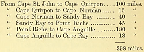
From Cape St. John
north to Cape Ray on the west, the distance is 398 geographical miles.
On this line of coast, the French possess the right by treaty, of
catching and drying fish, but are not allowed to make any permanent
erections, nor to remain longer than the time necessary to cure their
fish. Of course, all the residents are British subjects. According to
the returns in 1857, the population was as follows, on the west coast
principally :
1,647 Church of
England.
1,586 Church of Rome.
85 Wesleyans.
16 Free Church of Scotland.
3,334 Total.
There were 54
dwelling-houses, 1 Church of England, and 1 Roman Catholic. 1,508 acres
of land cultivated, yielding annually 1,204 tons hay; 40 bushels of
wheat and barley, 33 bushels of oats, 21,112 bushels of potatoes and
1,175 bushels of turnips. Of live stock, there were 87-‘5 neat cattle,
493 milch cows, 25 horses, 1,167 sheep, ami 310 swine and goats. Butter,
5242 lbs., cheese, 112 lbs., 453 yards of coarse cloth manufactured, 25
vessels engaged in the fisheries, 845 boats, carrying from 4 to 30
quintals ; nets and Seines, 2,354 ; codfish cured, 25,592 quintals ; 437
tierces of salmon, 17,908 barrels of herring, 13,609 seals, 1,391 seal
nets, 10,896 gallons of oil.
Regarding the moral
condition of the inhabitants of St. George’s Bay, the reader will be
able to gather some information from the following extract of a letter
from the Rev. Mr. Meek, Church of England Missionary, written in 1840
:—-
“I came to the place
five years since, as confessedly one of the most obscure, most
neglected, and most unpromising places in the island ; and, though I
have received in it many blessings, and though both myself and family
are, and have been, in the enjoyment of constant health, and though I
have seen at times cause for hope that I might be permitted with
acceptance and success, though less than the least of those who have
been entrusted with the commission, to ‘preach the Gospel to every
creature,’ to fulfil this blessed trust in this remote and uncultivated
spot, yet I find that I undertook no light or unanxious engagement; and
I confess that the last year and a half has been to me a season of
painful trial, as standing alone in the midst of surrounding evil,
which, not by power, nor by might, but by God’s spirit alone, can be met
or overcome; and I have been ready, like another Jonah, to flee from
proclaiming what is very unwelcome truth.
Owing to the peculiar
circumstances of the place, which, by treaty with the French, has
engaged to have no settlement in it, there neither is, nor can be, an}'
law or authority exercised ; consequently it is now become the
rendezvous of such as have no fear of God, and are glad to escape from
the control of man. You have, perhaps, heard of the wreck which occurred
here last fall, and some of the painful circumstances connected with it:
the parties concerned have, however, thus far escaped, and are here ;
and I should feel little trouble on their account, were it not that, in
connexion with others of like mind, they are leading the too-easily-led
people into such constant habits of drunkenness, revelling, fighting,
&c., that it must be manifest to you how painful is that duty which
constrains me to declare in such a place, that they who do such things
shall not inherit the kingdom of God ; yet this is my situation ; and
often with the sound of the midnight revel in our ears do we lie
sleepless, and mentally saying, ‘Woe is me that I sojourn in Mesech,
that I dwell in the tents of Kedar ! ’
“I am happy to say
that, after a good deal of trouble, the church is at length nearly
completed. It is one of the neatest outharbour churches in the island,
and is in general, especially in the winter, well attended; and, though
I have much to try and discourage, I have still much pleasure in
declaring, even to the worst, that Jesus Christ came into the world to
save sinners.
“The school continues
much as usual; it cannot be large till the settlement enlarges. About 40
children are usually present in the summer, and 50 in the winter. Of
course there is considerable improvement in the ability to read and
write, where no means were ever afforded for enabling any to do so; but
I regret that the constant bad examples around, and the want of parental
control, are far from being productive of good on the young."
In 1848, Mr. Meek
agfain writes:
“We passed, in many
respects, a trying winter: our neighbours were as poor as ourselves.
There were no stores or ships to go to; the poor Acadians were living
entirely upon eels, obtained through the ice, without bread or flour, or
anything else, and there were many things to depress and discourage; but
to school and to church we, without interruption, went, and, I trust,
have been thus far enabled to continue the unvarying testimony, that ‘
Neither is there salvation in any other, for there is none other name
under heaven given among men, save that of Jesus Christ alone, whereby
they must be saved.’ Yet here, alas, too, we have much to discourage—an
insensibility, an apathy, an almost opposition in many. Of one, indeed,
the chief fiddler hitherto at the dances, we have pleasing hope that
there is some good thing toward the Lord God of Israel. He has long
beten a regular and serious worshipper in our congregation, but now he
has, and that in spite of urgent solicitation and offers of some value,
renounced for ever his former employment, and, as far as he knows it,
determined to pursue the narrow way; but, in general, it is uphill work.
“You would be greatly
surprised at the peculiar circumstances of this strange place: they are
unlike every other even in Newfoundland. There is a great deal of abject
poverty, mixed up with a fondness for dress and appearance, that is very
painful. White veils and parasols adorn females who are seen at the
herring pickling ; indeed, there is scarcely an idea of any distinction
in society, and it is almost impossible to impress the folly and
absurdity of such contradiction to all that is becoming on them. Yet
these ladies are found at the balls, to which they are so much attached,
mixed up with Indians, Acadians, French, little children, and an
indiscriminate collection of all sorts and conditions. Oh, how we are
often pained and tried ! but never so much, T think, as on last New
Year’s Day, when, after I had preached the most solemn and pointed
sermon I could write (and I would send you the M.S. but for the expense
of postage), the congregation went out of church to a dance, which
continued till twelve at night, when, being Saturday, it was
discontinued. Surely I slept not that night, and went to church next day
with a heavy heart, and a cry, ‘Woe is me, that I am constrained to
dwell with Mesech!’
“We are greatly
indebted to Miss Hay don, of Guilford, for a box of clothing, partly for
the poor, and partly to relieve the wants of my own family, in
consequence of last summer’s catastrophe. It serves to reassure and help
us on in our solitary course, that friends so far off remember and
sympathise with us; and we hope that, upheld by their prayers, we shall
be enabled to hold on our way, and witness a good confession, and that
still we shall continue in church and school to teach and preach Jesus
Christ.
“It will be a long time
before we can hear from you again, or from anybody : remember how much
we need your prayers when we sit down alone in this solitude, surrounded
by so many who know not God, and obey not the Gospel of our Lord Jesus
Christ. The cold we can bear, the snow we can wade through, but the
dreadful apathy and insensibility around freezes up the soul. Alas, how
different is the missionary’s life to what the youthful listener in a
London public meeting imagines ! and nowhere, I think, is it more tried
than in Newfoundland. But I must commend myself, Mrs. M., our five
children and our charge, once more to your prayers and sympathies. I
have been more than nineteen years at work here and am forty-seven years
of age; I feel that the night cometh, that I have a trust to fulfil, and
an account to give, but He that has helped me hitherto will help me all
my journey through.”
The Rev. Mr. Meek
removed from St. George’s Bay to Prince Edward Island, and was succeeded
in the Mission by the Rev. Thomas Boland.
“In March, 1856, he
went to visit a parishioner a short distance from Sandy Point, the place
of his residence; and, not returning when expected, search was made for
him, and he was found dead within a mile of his own house. It is
presumed, that having incautiously gone alone, he had lost his way in a
drift; and, yielding to cold and fatigue, had sunk into that fatal sleep
in which the vital powers are soon extinct.
“The Rev. Thomas Boland
had, before his ordination, been for several years a Scripture Reader in
the Parish of Whitechapel, and was highly commended to the Society by
several clergymen to whom he had been favourably known in that part of
the town. The Rev. W. W. Champnevs, in particular, testified to ‘ his
genuine piety, decided ability, and the soundness of his views.’ He went
to Newfoundland in 1849. The obituary notice characterises him as a
person of much learning, ability, and zeal; and adds, tha this ministry
appeared to be much blessed in the remote settlements—first of Channel,
and afterwards of St. George’s Bay, to which he was sent as the
Society’s Missionary by the present Bishop of Newfoundland, by whom he
was ordained both deacon and priest.”
The Rev. H. Lind
succeeded Mr. Boland in the Mission of St. George’s Bay. The following
incident is related by Mr. Lind:
“An Indian mountaineer
had been hunting, and had killed a deer, the skin of which he had
wrapped about his person, when a bear met him, and, no doubt, tempted by
the smell of blood, knocked him down, and would have torn him to pieces,
when his daughter, seeing the danger of her father, crept quietly to
him, and, at the risk of her own life, took his hunting-knife from his
belt, and plunged it into the body of the infuriated beast, which fell
dead at her feet, and thus liberated her parent.”
In 1849, Bishop Field
made an episcopal visit to this part of the Coast. The following is an
extract from an account of the Bishop's visit:—
“Leaving
Port-aux-Basques the same evening, the Church Ship was anchored in
Codroy Boads earlv on Thursday morning, July 26th. Here two services
were held in the house of a respectable planter; and in the evening
service (at 6 o’clock) several children were admitted into the Church.
These people had seen no Clergymen among them since the Bishop’s visit
four years ago. Between the services the Bishop, with two of his Clergy,
went over to the great Codroy River, (six miles) and there baptized
three children. The Bishop then returned to hold the promised service at
Codroy, but the Clergy proceeded six miles further to the Little River.
Fifteen years ago Archdeacon Wix visited these settlements, and baptized
there ; but no Clergyman has been seen, no service of our Church
performed there since. The worldly circumstances of the inhabitants are
in direct contrast to their spiritual and religious condition, for they
enjoy the produce of the land as well as of the sea in abundance. They
have numerous flocks of fine cattle, and grow various kinds of corn with
a little labour, and a large return.
“The wind being fair it
was thought prudent to proceed the same night to Sandy Point (Mr. Meek’s
mission), at the head of St. George’s Bay. At the time of the Bishop’s
visit to this mission last year, Mr. Meek had unfortunately just sailed
for St. John’s. On this occasion he was prepared for and anxiously
expecting his Lordship.
“The Church Ship
remained in this Harbour three days, and on Sunday the Bishop celebrated
the Holy Communion in the morning, and gave Confirmation in the
afternoon service
Four long years had
elapsed since either of those Holy Services had been celebrated in this
settlement, and years of peculiar trial to the Missionary and his flock.
During the Bishop’s stay, the Wellesley, Flag Ship, with the Admiral,
Earl Dundonald, on board, arrived, and remained two days in the harbour.
“On Tuesday, July 31st,
the Church Ship sailed for the Bay of Islands, which was reached and
entered in safety early the following day. Here is the place, and here
the people whose condition, as reported by Archdeacon Wix fifteen years
ago, excited so much commiseration. It may readily be supposed that as
no Minister of Religion, and no teacher of any name or persuasion, had
visited them in the long interval, their moral state can only have
become more wretched and degraded. The people are settled in most
picturesque and fertile spots on either side of the Humber Sound, which
for beauty of scenery, size and variety of timber, and richness of soil,
is perhaps the most favoured locality in Newfoundland. The condition of
the inhabitants in moral and social circumstances stands in strong and
unhappy contrast; and they do not generally appear to know even how to
turn to account their natural advantages. Several families were found in
a state of deplorable destitution. Others, more prosperous or more
careful, were not less ignorant and unmindful of any concerns or
interests beyond the provision for this life. The Church Ship remained
the rest of the week, four days, in the Bay; and every day was fully
occupied in visiting the people from house to house, baptizing and
admitting into the Church the children under fifteen years of age, and
giving to young and old such exhortation and advice as seemed best
suited to their unhappy state.
“It was a melancholy
thing to leave them to their former darkness and destitution, but there
was too much reason to expect that others would be found in a similar
condition, along the shore.
“The Church Ship left
the Bay of Islands at midnight, on Saturday, August 4th, and at 9
o’clock the next morning called off a settlement at Trout River, were,
without coming to anchor, the Bishop and his Clergy celebrated Divine
Service on shore. Morniug Service was celebrated on board after the
Bishop’s return. By four o’clock the Church Ship was anchored in Rocky
Harbour, at the mouth of Bonne Bay, and, after holding Evening Service
on board, the Bishop and Clergy went on shore, and baptized and received
into the Church a large number of interesting children :—and thus four
full Ser vices were celebrated on that Sunday, two on board, and two on
shore. No Clergyman of our Church had ever before visited these
settlements: but in each of them the patriarch, or head of the
settlement, was an Englishman, and could read, and hail brought and used
both his Bible anil Prayer-book, and the difference, in their favour,
between them and their neighbours at the Bay of Islands, was very
perceptible.
“Monday, August C.— The
Church Ship reached Cow Cove, another settlement never before visited by
a clergyman, and too much resembling in moral misery and degradation the
Bay of Islands. On the Tuesday such religious services were performed as
were required, and could properly be allowed under the circumstances of
the people. The settlements of Cow Harbour, Bonne Bay, Trout Cove, and
Bay of Islands, would together afford abundant occupation for a diligent
and devoted Missionary. They number at least three hundred souls.
“Wednesday morning,
August 8.—The shores of Labradoi came in sight, and the same evening the
Bay of Forteau again saw and received the Church Ship, according to
promise given last year.
“Thursday, August
11th.—The Bishop with his whole party visited L’Anse Amour and L’Anse a
Loup, and on the following day consecrated a grave-vard in the first
named settlement. Here the Rev. Mr. Gifford was introduced to his
mission, and was most kindly welcomed by Mr. Davies, and provided
immediately with a comfortable lodging. It was the Bishop’s wish,
however, that he should visit some other chief settlements in his
mission in the Church Ship, to have the benefit of a proper
introduction.
“Saturday, August
11.—The Church Ship sailed to Blanc Sablon, where the Messrs. Do
Quetetville, of Jersey, have a large establishment. Here a small river
divides the dependencies of Newfoundland on this coast from Canada, and,
of course, limits the Bishop’s Diocese. It was said to be the first
limit or end of his Diocese his lordship ever saw. In a store kindly
furnished by the agent (who seemed desirous to promote in every way the
objects of the Bishop’s visit), divine service was celebrated twice on
Sunday, August 12. The Holy Communion was administered. The Bishop
preached in the morning, and Mr. Gifford in the afternoon. The
congregation was large on each occasion, and consisted almost entirely
of the men connected with the establishment, and employed on the room.”
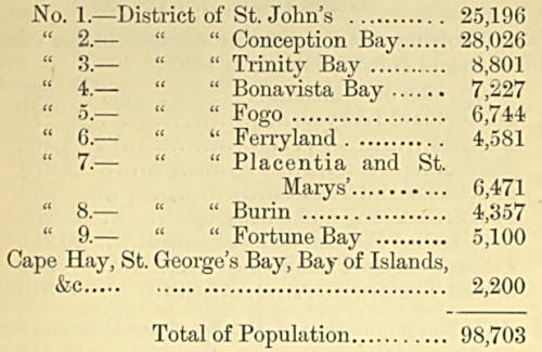
Recapitulation of the
Population of the Districts, 1849 :—
Population of the
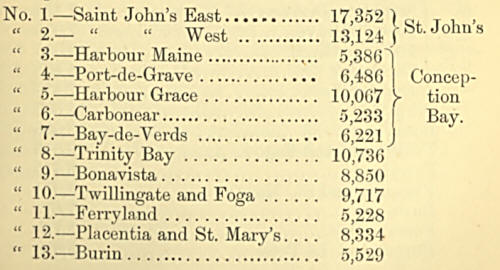
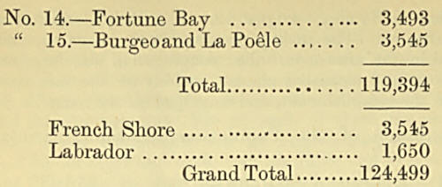
Districts in 1857 :—
The following was the
number engaged in the various professions, in Newfoundland, in 1857 :
Clergymen or
Ministers............... 77
Doctors and Lawyers...................... 71
Farmers............. ......................... 1,552
Mechanics. . ................................ 1,970
Merchants and Traders...................... 689
Persons catching and curing fish......... 38,578
Able-bodied Seamen and Fishermen...... 20,311
Persons engaged lumbering................ 334
School Teachers ........................... 310
In 1874 the population
of the Electoral Districts:—
St. Johns,
East.-............................. 17,811
St. Johns, West.............................. 12,763
Southern Division...................... 7,174
Port-de-Grave............................ 7,918
Harbour Grace.......................... 13,055
Carbonear.................................. 5,488
Bay De Verds........................... 7,434
Trinity....................................... 15,667
Bonavista.................................... 13,008
Twillingate and Fago................... 13,643
Ferryland................................... 6,419
Placentia and St. Mary’s ................ 9,974
Burin.......................................... 7,678
Fortune Bay................................... 5,788
Burgeo and La Poele.................... 5,098
Total..............148,919
French Shore 8,651
Labrador 2,416
The census taken in
1869, show the following returns: Population, 146,596, consisting of,
Catholics, 61,040; Church of England, 55,184; Congregationalists, 338;
Wesleyans, 28,900; Presbyterians, 974; other denominations, 10. The
number of churches was 235. No less than 136,378 of the population are
returned as born in the Colony. Of the children, 16,249 are reported as
attending school, and 18,813 as non-attendants, but this would include
many of very tender years. The census also shows 37,259 to be engaged in
the fisheries, 20,617 as seamen, and 1,784 as farmers, while 99 are
clergymen, 24 are lawyers, 591 merchants, and 2,019 mechanics. The land
under culture amounted to 41,715 acres; the growth of turnips to 17,100
bushels; of potatoes, to 308,357 bushels; of other roots, to 9,847
bushels; of hay, to 20,458 tons; and of butter, to 162,508 lbs. The
vessels numbered 986, with a tonnage of 47,413 tons; boats, 14,755; nets
and seines, 26,523: seal nets, 4,761; persons engaged in the fisheries,
37,259; and seamen, 20,647. The horses numbered 3,764 ; horned cattle,
13,721; sheep, 23,044; goats, 6,417; and swine, 19,081. The product of
the fisheries was given in the census of 1869 as follows:—Cod, 1,087,781
quintals; salmon (cured), 33,149 tierces; herrings 97,035 barrels; other
fish (cured), 10,365 barrels; fish oil, 840,304 gallons; and seals,
333,056. The manufactures, on the other hand, amounted only to $72,675
in value.


