|
One of the greatest tasks
of successive Governments of Canada has been the settlement of the
western prairies. Generally this has been encouraged by free grant lands
to actual settlers and to colonization companies or railway
corporations. In recent years, in fact since 1897, grants to railways
have been discontinued and the policy of granting tracts to colonization
companies has practically ceased. Land is now reserved to the actual
settlers.
The first step in the
settlement of the prairies was the adoption and execution of a system of
survey. After the transfer of the Hudson's Bay Company's rights to the
Government of Canada, immigrants began to come. The completion of the
Dawson Route and the Northern Pacific Railway in 1872 gave a great
impetus to immigration and created conditions which called for prompt
measures to place the settlers on the land. At the time of the transfer,
settlement was confined to the river banks of the Red and Assiniboine
Rivers, where the Selkirk settlers and others occupied lots varying from
one and one-half chains to twenty chains in width and extending back
from the banks of the river a distance of about two miles.
The Dominion Lands Office
was organized in March, 1871, under John Stoughton Dennis,
Surveyor-General, and the first regulations respecting the disposal of
Dominion lands were issued on April 25th, 1871. Under these regulations,
unappropriated, surveyed Crown lands were offered for sale at $1.00 per
acre, limited to 640 acres to any one person. Pre-emption and homestead
rights were established and provision made for the first railway subsidy
in the North West Territories. Lands subject to the regulations might be
withdrawn from settlement to provide a strip three townships wide on
each side of the route of the proposed Inter Oceanic Railway.
The first Dominion Lands
Act was passed in 1872. This Act has been amended from time to time to
meet the changing conditions of the country, but its main features have
persisted to the present and are embodied in the Dominion Lands Act of
1908 and amendments thereto. Numerous survey parties were placed in the
field under the supervision of Mr. Lindsay Russell and a grand scheme of
surveys outlined which embraced the whole of the North West Territories.
Meridians and bases were surveyed and explorations carried on to locate
the timber areas and sources of water supply. To ensure that in any one
township the greatest possible number of settlers should benefit from
the timber found there and to prevent a monopoly thereof by the first
settlers, the Act provided that the timbered sections should be divided
into wood lots and that one lot should be apportioned to each homestead
of 160 acres. This regulation applied only to surveyed lands. The right
to take timber or unsurveyed lands was regulated by permit, a system
which still exists.
DISPOSAL OF DOMINION
LANDS.
Under the powers
contained in the Dominion Lands Act of 1872, and succeeding Acts, and
regulations based thereon the Dominion lands of Western Canada have been
disposed of in the following way.
(1) Half breed scrip.
(2) Hudson's Bay reservations of one-twentieth of the surveyed land
south of North Saskatchewan River.
(3) Lands reserved for education (school lands).
(4) Military bounty lands.
(5) Homesteads and pre-emptions to actual settlers.
(6) Grants to railway companies.
(7) Sales to colonization companies.
(8) Special sales of agricultural lands not exceeding one section; also
sales of fractional quarter sections in special cases.
(9) Sale or lease of grazing, hay or marsh lands under special
regulations of Governor-in-Council.
(10) Sale or lease of mining lands (i. e., containing salt, petroleum,
natural gas, coal, gold, silver, copper, iron or other minerals) under
special regulations of Governor-in-Council.
(11) Grants to original white settlers who were born in the North West
Territories or were resident prior to March 8, 1869. This time was
extended to July 15, 1870, by 38 Viet. C. 52.
(12) Indian Reservations.
(13) Soldier settlement grants.
HALF BREED SCRIP.
By the Manitoba Act (Sec.
31) provision was made for the first time for land grants to the half
breeds of that Province. An area of 1,400,000 acres was set apart to be
distributed under regulations of the Governor-in-Council. Every half
breed resident in Manitoba on July 15, 1870, and every child of such
half breed became entitled to participate in the grant of 1,400,000
acres. These grants were free from any services or payment. The claims
of the half breeds in the North West Territories were first dealt with
in 1879. The Dominion Lands Act of that year provided for the
satisfaction of the claims of the half breeds resident in the North West
Territories outside the limits of Manitoba oil 15, 1870, by land grants
and the issue of scrip redeemable in land. These people had settled
mainly along the lake and river fronts. When this enactment was executed
by the O. C. March 30, 1885, those half breeds in bona fide possession
were given plots of not more than 40 acres each along the water fronts
at 81.00 per acre. In addition they were allowed to select 160 acres
from lands open for homestead and pre-emption entry as near as possible
to their holdings. The children of half breeds born before July 15,
1870, and 1885 were given certificates entitling them to select 240
acres from any lands open for homestead entry.
A commission was
appointed in 1885 consisting of Messrs W. P. R. Street, Roger Goulet and
A. E. Forget to ascertain the number of half breeds in the North West
Territories. On certificates issued by the commission, scrip was issued
to 854 heads of families, the representatives of 264 deceased heads of
families, 1,862 children, and the representatives of 466 children born
in the North West Territories before July 15, 1870, but who died before
1885. The whole amount of scrip issued represented 61,020 acres of land
and 8663,474.00 in money scrip redeemable in land.
HUDSON'S BAY COMPANY'S
LANDS.
By the deed of surrender
from the Hudson's Bay Company in 1870, to the Crown, one-twentieth of
the surveyed lands of the North West Territories, south of the North
Saskatchewan River, was reserved to the Company. The right to claim the
one-twentieth remained good for fifty years from the date of surrender,
but all claims to lands in any township had to be made within 10 years
from the date of survey. The company retained all its trading posts and
stores and in addition was allowed to select parcels of land in the
vicinity of the posts, the aggregate of which was not to exceed 50,000
acres throughout the whole of the North-West.. The fraction of
one-twentieth of the surveyed lands is computed as follows: In every
fifth row of townships the whole of sections 8 and 26 and in each and
every of the other townships, the whole of section 8 and three-quarters
of section 26. Out of a total of 6,556,000 acres surveyed, 2,175,700
acres are situated in Alberta. Up to March 31, 1922, the company has
sold a total acreage in Western Canada of 3,544,580, for the sum of
843,345,000.
SCHOOL LANDS.
Sections 11 and 29 are
set apart in every township surveyed by the Dominion Government in
Alberta, Saskatchewan and Manitoba and the North West Territories for
the support of education. The lands are held in trust by the Dominion
for the provinces. They are sold from time to time and the money
invested in securities of Canada. The interest arising therefrom after
deducting the cost of management is paid annually to the provinces
within which such lands are situated. The money is applied exclusively
to the support of public schools. Up to March 31, 1922, the area of
school lands disposed of by the Dominion Government in the Province of
Alberta, after making deductions for canceled sales, was 952,164 acres,
valued at 313,161,415. The rate of interest allowed the Province was
raised from 5 per cent to 6 per cent in 1918.
MILITARY BOUNTY LAND
SCRIP.
By 0. C., April 25, 1871,
each officer and man of the Ontario and Quebec battalions of Rifles then
stationed in Manitoba was given a free grant of 160 acres without actual
residence.
By 48-49 Viet. C. 93,
grants of land were given to the militiamen engaged in the suppression
of the half-breed and Indian rising of 1885 in the North West
Territories. Each member of the militia was given the right to homestead
320 acres in any even numbered section of unoccupied Dominion Lands,
provided application was made for entry before August 1, 1886. In the
following year the same rights were conferred upon members of the
irregular forces engaged in suppressing the rebellion (49 Viet. C. 29).
By the Volunteer Bounty Act, 1908 (7-8 Edw. VII. C. 67) every volunteer
domiciled in Canada who served with the British forces in South Africa
during the years from 1899 to 1902 became entitled to a grant of two
adjoining quarter sections, lands available for homestead entry, subject
to homesteading conditions. Provision was made for the issue of scrip
instead of land. No more than 207c of the land in any one township could
be opened for Military Bounty Scrip. The right to obtain military bounty
grants expired October 31, 1913.
HOMESTEAD AND PRE-EMPTION
LANDS.
The first homestead and
pre-emption regulations were authorized by O. C., April 25, 1871. These
remained in force until 1879. Up to that year both odd and even numbered
sections were open for entry. In that year the Government put into
operation the policy of railway land subsidies and reserved for this
purpose every odd numbered section. Pre-emption privileges were
abolished on January 1, 1890. After 1896 the Government forced the
railway companies to select all the lands they had earned and
discontinued the policy of encouraging railway construction by land
grants. On September 1, 1908, odd and even numbered sections were again
thrown open for homestead entry. Pre-emption rights were revived at the
same time to apply to that part of Alberta and Saskatchewan comprised
within the following boundaries:
"Commencing where the
west line of range twenty-six west of the fourth principal meridian
intersects the international boundary; thence east along the
international boundary to its intersection with the Minneapolis, St.
Paul and Sault Ste. Marie Railway; thence northwest along the said
railway line to its junction with the main line of the Canadian Pacific
Railway; thence west along the Canadian Pacific Railway to the third
principal meridian; thence north along the third principal meridian to
the north line of township forty-four to the Calgary and Edmonton
Railway; thence south along the Calgary and Edmonton Railway to its
intersection with the west line of range twenty-six west of the fourth
meridian; thence south along the west line of the said range twenty-six
to the international boundary." Pre-emption privileges were abolished
iii 1914.
Regulations governing
homestead entry remain substantially the same as those first issued in
1870. Every male person over 18 years of age who is a British subject,
or declares his intention to become such is entitled to obtain entry
upon payment of a fee of $10.00. A widow having minor children of her
own dependent upon her may make homestead entry. Application must be
made by the applicant in person at the Dominion Land Office or
sub-office in which the land is situated. Entry by proxy is permitted
only in the case of a father, son, brother, or sister.
RAILWAY LAND GRANTS.
In 1879 the government of
Canada set apart 100,000,000 acres of land in the North West Territories
for the support of railway construction in Western Canada (0. C. June
28, 1879). The land regulations of 1871 were superseded by new
regulations, authorized by orders in Council dated July 9, and October
14, 1879. Odd numbered sections in surveyed territory were reserved for
railways. Special regulations were adopted to apply to lands situated
within 110 miles on each side of the Canadian Pacific Railway. For the
purposes of the regulations the line of the Canadian Pacific Railway was
assumed to follow the fourth base line west of the Red River. The
country on both sides of the railway line was divided into belts as
follows:
(1) Belt A- 5 miles wide
on each side of railway line.
(2) Belt B-15 miles wide on each side of Belt A.
(3) Belt C-20 miles wide on each side of Belt B.
(4) Belt D-20 miles wide on each side of Belt C.
(5) Belt E-50 miles wide on each side of Belt D.
The lands in Belt A were
withdrawn from homestead or pre-emption entry, and placed on sale at
$6.00 per acre. In the other belts the odd numbered sections were
reserved for railway purposes and offered for sale at the following
rates: Belt B, $5 per acre; belt C, $3.50 per acre; belt D, $2.00 per
acre; belt E, $1.00 per acre. These prices were reduced shortly
afterwards.
The even numbered
sections were opened for homestead and preemption entry. A homesteader
was entitled to a free grant of 80 acres. The prices for preemptions
were as follows in the different belts: Belts B & C, $2.50 per acre;
belt D, $2.00 per acre; belt E, $1.00 per acre. These regulations were
changed by order in Council October 9, 1879, raising the homestead and
pre-emption entries to 160 acres each. These regulations were changed
again in 1881 (0. C., December 23, 1881) and again in 1889, but the
general rule of classifying the lands of the North West Territories with
respect to their proximity to the C. P. R. was preserved.
The regulations of 1881
classified the land as follows:
(a) Class A—Lands for 24
miles on each side of the main line of the C. P. R. or any branch
thereof.
(b) Class B—Lands within 12 miles on each side of any other railway.
(c) Class C—Lands south of the main line of the C. P. R. not included in
Class A or B.
(d) Class D—Lands beyond those belts.
The regulations of 1889
recognized two classes, namely:
(a) Class A—All lands in
the North West Territories south of the main line of the C. P. R.
(b) Class 13—Lands not included in Class A.
GRANTS TO COLONIZATION
COMPANIES.
The regulations of 1881
introduced a new principle in disposing of the public lands. Provision
was made for sales of large tracts of land to colonization companies.
The lands were to be selected from Class D mentioned above, i. e., lands
situated at least 24 miles north of the main line of the C. P. R. or
within 12 miles of any branch railway. Two plans were adopted:
Plan No. 1—Odd numbered
sections were sold at $2.00 per acre payable in five years. In return
the companies agreed to place within five years from the date of
purchase two settlers on each section. The settler received 160 acres as
a homestead and the right to purchase the adjoining quarter at $2.00 per
acre. At the end of the five-year period the company received a rebate
of one-half the original purchase price of the odd numbered sections.
Plan No. 2—To encourage
settlement by capitalists who desired to cultivate larger farms than
under the first plan large tracts in Class I) were sold at $2.00 per
acre cash upon the condition that the colonization company would agree
to place 128 settlers in each township within five years. If this
condition was fulfilled the company received a rebate of one-half the
original purchase price. By the end of 1883 over 26 companies were
operating in the North West Territories and had purchased 2,973,978
acres of land from the Government for the sum of $857,455. An inspection
of 12 out of the 26 indicated that 664 heads of families had been
attracted to the country by the Companies. This method of settlement was
never popular with the people of Western Canada. By Order-in-Council
June 30, 1886, the Government terminated the contracts made with the
Colonization Companies, and the policy was abandoned.
LEASES AND SALES OF LAND.
Leasehold privileges
extend to the following classes of Dominion lands:
(a) Grazing lands, but
not suitable for agriculture.
(b) Hay and marsh lands.
(c) Mineral lands and lands containing quarriable stone.
(d) Irrigation lands.
(e) Lands required for development of water power.
These privileges have
continued since the first land act of 1872, though they have been varied
from time to time by Order-in-Council to suit the growing conditions of
settlement.
Sales or leases of any
lands other than mineral lands do not convey title to the following
minerals: Salt, petroleum, coal, gold, silver, copper, iron or other
minerals.
Agricultural lands may be
purchased in parcels not exceeding 640 acres under regulations made by
the Governor-in-Council. Fractional quarters of less than 80 acres may
be sold to an adjoining homesteader or owner at a rate not less than
$3.00 per acre.
Soldier Settlement Land.
The return and discharge
of many thousands of Canadian soldiers during the late war led to a new
scheme for settling Dominion lands and increasing production, so
necessary for the prosecution of the war by the Allies. By the Soldier
Settlement Act of 1917, the Dominion Government undertook to assist
soldier settlers with cash loans not exceeding $2,500, according to the
needs of the individual soldier making homestead entry or purchasing
patented lands. Power was also given to the Government to reserve any
Dominion lands for the exclusive entry of soldier settlers.
The scope of this scheme
was enlarged in 1919. Under the Act of that year large powers were given
to the Soldier Settlement Board to reserve any Dominion lands, affect
compulsory purchase of private lands for soldier settlers, to train
soldiers in farming, establish training stations in agriculture and home
economics for settlers and provide subsistence allowances for such
settlers and their dependents during the course of training. The Board
was given power to sell the land so acquired to soldier settlers for
actual farming operations conducted by the purchaser. The maximum size
of a farm was 320 acres. The soldier settler was required to pay 10 per
cent of the purchase price at the time of the sale to him, and the
balance was spread over twenty-five equal, annual instalments, with
interest at 5 per cent on the amortization plan, with the privilege of
full payment at any time. In addition the Board could purchase live
stock and sell the same to the settler for cash, or four consecutive,
equal, annual instalments, commencing not later than three years from
the day of the sale of the stock to the settler, with interest at 5 per
cent. Advances for permanent improvements could be made up to S1,000,
repayable in twenty-five equal, annual instalments.
Under this Act 453,339
acres of Dominion lands have been settled on by 1,675 soldiers, and
691,959 acres of private or patented lands had been purchased for 3,542
soldiers in the Province of Alberta by the end of 1921.
Coal, Oil and Gas Lands:
The first regulations re
coal lands were issued in 1881 (Order-in-Council December 17, 1881) and
provided for twenty-one year leases of areas not greater than 320 acres,
subject to a ground rent of 25 cents per acre, and a royalty of 10 cents
per ton upon all coal taken out of the mine. Under these regulations it
was found that lessees were consolidating their holdings and bringing
large areas under one management. To obviate this practice the
Government, by Order-in-Council December 26, 1882, discontinued leasing
in districts where the known existence of coal close to facilities for
reaching a market indicated them as early centres of the coal industry.
These districts were the Souris River, Bow River, Belly River and
Saskatchewan River coal districts. Provision was also made for
converting leaseholds into freeholds. By Order-in-Council March 2, 1883,
the lands in the above coal districts were opened for sale in areas not
exceeding 320 acres to one person at the rate of $10 per acre for
surface and under rights. The regulations were changed again four years
later. By Order-in-Council, October 30, 1887, all minerals were reserved
to the Crown in patents granted in respect of the surface rights of
Dominion lands.
These regulations
continued until 1907. The development of Western Canada created a great
demand for coal lands, consequently the Government withdrew all coal
lands from sale and established a leasing system again. By
Order-in-Council March 9, 1907, new regulations were proclaimed which,
with minor changes, are still in force.
Oil and gas lands are
subject to regulations similar to those regulating the use of coal
lands. These lands may be leased only for a period of twenty-one years,
subject to certain conditions respecting drilling and development, at a
rental of 50 cents per acre for the first year, and a rental of $1.00
per acre for each subsequent year during the term of the lease. The
maximum area which may be acquired, except by assignment, by one person
or corporation is 1,920 acres.
SYSTEM OF SURVEY.
The Township:
Dominion lands are laid
off in quadrilateral townships containing thirty-six sections of one
square mile each, together with road allowances of:
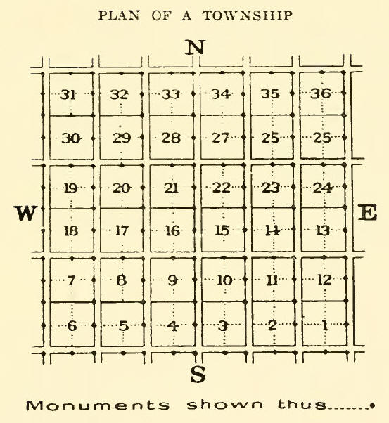
one chain and fifty links
wide between townships and sections. Road allowances running east and
west are two miles apart, while those running north and south are one
mile apart.
Meridians and Base Lines:
Townships are numbered
from the First Base Line, which is the 49th parallel of latitude,
northward, and lie in ranges west of certain initial meridians, the
first of which is called the Principal Meridian. This is a line run from
a point ten miles west of Pembina, near where the Red River crosses the
International Boundary on latitude 49 North, in 1869. It runs a few
miles west of Winnipeg. The number of ranges between the meridians
varies from 30 at the First Base Line or township one to 26 at township
80, decreasing with increase of latitude. There are six initial meridian
lines west of the First Meridian. The Fourth forms the boundary between
Alberta and Saskatchewan. The Fifth runs a few miles west of Edmonton.
The Sixth, the last to be surveyed, lies within 70 miles of boundary
between Alberta and British Columbia.
Base lines are surveyed
parallel to Latitude 49, every 24 miles. Correction lines or those
resulting from the convergence of meridians lie midway between the base
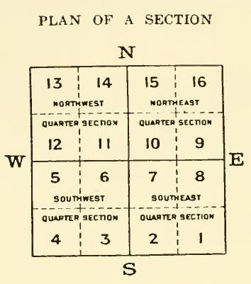
lines. Each section contains 640 acres more or less, and is divided into
four quarter sections containing 160 acres more or less, which are
described as S. E., S. W., N. W., and N. E. quarters. The sections are
numbered from the south-east corner westward in each township, the
second tier of sections being numbered from west to east and so on
alternately throughout the township, the last section 36, being situated
ifl the north-east corner of the township, as shown in the diagram
below. The sections are subdivided into quarters. By this system it is
possible by :1 very simple formula to designate the exact location of
any quarter section in any part of the three Provinces of Manitoba,
Saskatchewan or Alberta.
Each section is deemed to
be divided in 40 acre areas known as legal subdivisions, and numbered
and bounded as in the diagram below.
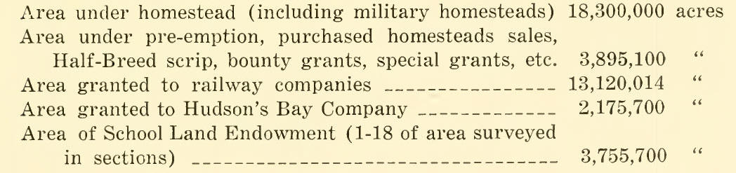
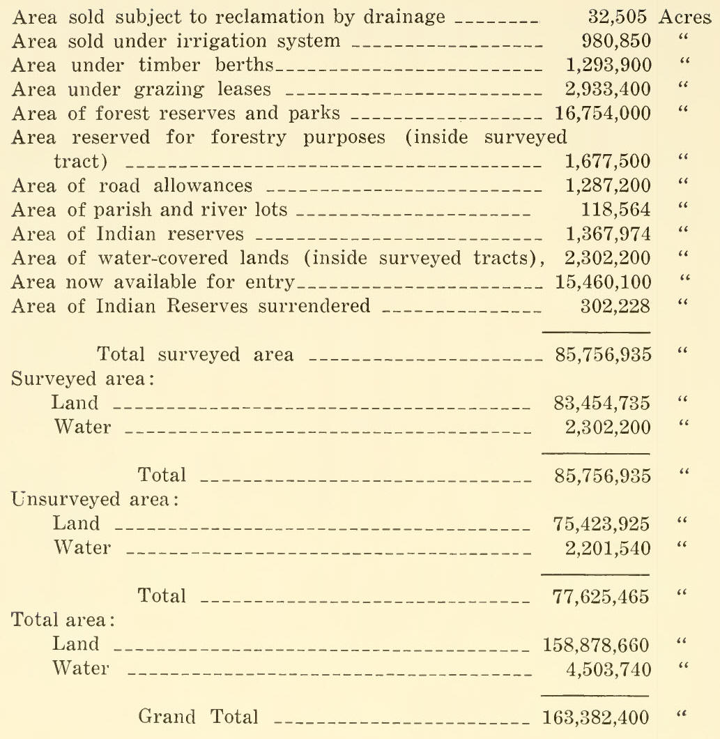
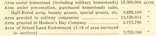
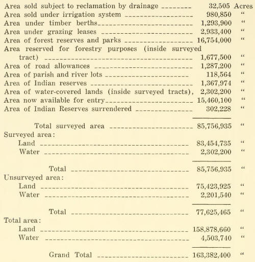
LAND SITUATION TODAY.
The total area of Alberta
is placed by the Department of the Interior at 163,382,400 acres. Of
this area 85,756,935 acres have been surveyed and the disposition of
such lands is shown in the following statement at the end of the fiscal
year, March 31, 1922:
 |